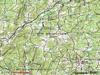
New Braintree, Massachusetts
Submit your own pictures of this town and show them to the world
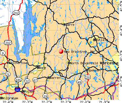
- OSM Map
- General Map
- Google Map
- MSN Map
Population change since 2000: +7.8%
 |
| Males: 501 | |
| Females: 498 |
| Median resident age: | 43.3 years |
| Massachusetts median age: | 39.2 years |
Zip codes: 01531.
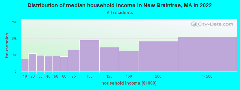
| New Braintree: | $98,816 |
| MA: | $94,488 |
Estimated per capita income in 2022: $41,086 (it was $21,072 in 2000)
New Braintree town income, earnings, and wages data
Estimated median house or condo value in 2022: $426,939 (it was $154,600 in 2000)
| New Braintree: | $426,939 |
| MA: | $534,700 |
Mean prices in 2022: all housing units: $419,164; detached houses: $447,621; townhouses or other attached units: $343,592; in 2-unit structures: $323,295; in 3-to-4-unit structures: $332,295; in 5-or-more-unit structures: $232,758; mobile homes: $113,885
Detailed information about poverty and poor residents in New Braintree, MA


- 96896.9%White alone
- 101.0%Two or more races
- 80.8%Hispanic
- 60.6%Asian alone
- 40.4%American Indian alone
- 30.3%Black alone
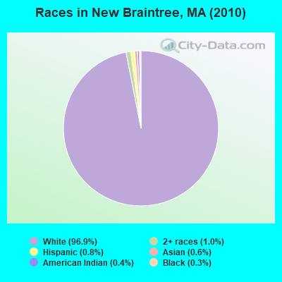
Races in New Braintree detailed stats: ancestries, foreign born residents, place of birth
According to our research of Massachusetts and other state lists, there was 1 registered sex offender living in New Braintree, Massachusetts as of May 19, 2024.
The ratio of all residents to sex offenders in New Braintree is 999 to 1.
Type |
2018 |
2019 |
2020 |
2021 |
2022 |
|---|---|---|---|---|---|
| Murders (per 100,000) | 0 (0.0) | 0 (0.0) | 0 (0.0) | 0 (0.0) | 0 (0.0) |
| Rapes (per 100,000) | 0 (0.0) | 0 (0.0) | 0 (0.0) | 0 (0.0) | 0 (0.0) |
| Robberies (per 100,000) | 0 (0.0) | 0 (0.0) | 0 (0.0) | 0 (0.0) | 0 (0.0) |
| Assaults (per 100,000) | 1 (97.3) | 3 (293.0) | 1 (97.9) | 4 (388.3) | 2 (201.4) |
| Burglaries (per 100,000) | 0 (0.0) | 2 (195.3) | 1 (97.9) | 0 (0.0) | 0 (0.0) |
| Thefts (per 100,000) | 3 (291.8) | 1 (97.7) | 2 (195.9) | 1 (97.1) | 1 (100.7) |
| Auto thefts (per 100,000) | 1 (97.3) | 1 (97.7) | 1 (97.9) | 2 (194.2) | 2 (201.4) |
| Arson (per 100,000) | 0 (0.0) | 0 (0.0) | 0 (0.0) | 0 (0.0) | 0 (0.0) |
| City-Data.com crime index | 38.9 | 84.0 | 42.1 | 97.1 | 60.4 |
The City-Data.com crime index weighs serious crimes and violent crimes more heavily. Higher means more crime, U.S. average is 246.1. It adjusts for the number of visitors and daily workers commuting into cities.
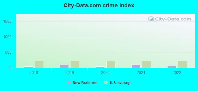
Crime rate in New Braintree detailed stats: murders, rapes, robberies, assaults, burglaries, thefts, arson
Full-time law enforcement employees in 2013, including police officers: 1 (1 officers - 1 male; 0 female).
| Officers per 1,000 residents here: | 0.97 |
| Massachusetts average: | 2.51 |
 Recent articles from our blog. Our writers, many of them Ph.D. graduates or candidates, create easy-to-read articles on a wide variety of topics.

 | Dave Andelman Resigns From The Phantom Gourmet Food Show (171 replies) |
| Town in Massachusetts You’d Least Like To Live In? (179 replies) |
| What is living in North Brookfield like? (6 replies) |
| Sand vs salt, Quabbin hill towns. (1 reply) |
| How Much Massachusetts Households Make Per Year: Census Data (37 replies) |
| Boundaries of MA's regions (63 replies) |
Latest news from New Braintree, MA collected exclusively by city-data.com from local newspapers, TV, and radio stations
Ancestries: French (20.7%), Irish (19.6%), English (16.9%), Polish (11.5%), French Canadian (8.8%), German (7.0%).
Current Local Time: EST time zone
Incorporated in 1775
Elevation: 945 feet
Land area: 20.7 square miles.
Population density: 48 people per square mile (very low).
18 residents are foreign born
| This town: | 1.9% |
| Massachusetts: | 12.2% |
| New Braintree town: | 1.3% ($2,060) |
| Massachusetts: | 1.3% ($2,336) |
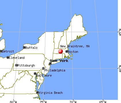
Nearest city with pop. 50,000+: Worcester, MA  (16.6 miles , pop. 172,648).
Nearest city with pop. 200,000+: Boston, MA (52.9 miles , pop. 589,141).
Nearest city with pop. 1,000,000+: Bronx, NY (136.2 miles , pop. 1,332,650).
Nearest cities:
), Latitude: 42.32 N, Longitude: 72.12 W

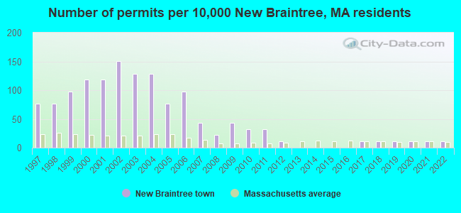
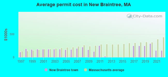
Single-family new house construction building permits:
- 2022: 1 building, cost: $150,000
- 2021: 1 building, cost: $150,000
- 2020: 1 building, cost: $300,000
- 2019: 1 building, cost: $250,000
- 2018: 1 building, cost: $250,000
- 2017: 1 building, cost: $250,000
- 2012: 1 building, cost: $25,500
- 2011: 3 buildings, average cost: $256,700
- 2010: 3 buildings, average cost: $125,000
- 2009: 4 buildings, average cost: $167,300
- 2008: 2 buildings, average cost: $220,000
- 2007: 4 buildings, average cost: $196,000
- 2006: 9 buildings, average cost: $168,900
- 2005: 7 buildings, average cost: $168,000
- 2004: 12 buildings, average cost: $175,900
- 2003: 12 buildings, average cost: $175,900
- 2002: 14 buildings, average cost: $176,000
- 2001: 11 buildings, average cost: $175,800
- 2000: 11 buildings, average cost: $176,600
- 1999: 9 buildings, average cost: $172,200
- 1998: 7 buildings, average cost: $188,500
- 1997: 7 buildings, average cost: $115,000
| Here: | 3.7% |
| Massachusetts: | 3.5% |

- Construction (9.8%)
- Health care (9.8%)
- Educational services (7.9%)
- Agriculture, forestry, fishing & hunting (6.5%)
- Professional, scientific, technical services (4.7%)
- Nonmetallic mineral products (4.7%)
- Accommodation & food services (4.1%)
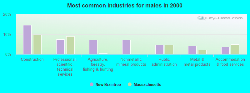
- Construction (14.6%)
- Professional, scientific, technical services (7.5%)
- Agriculture, forestry, fishing & hunting (7.1%)
- Nonmetallic mineral products (7.1%)
- Public administration (4.9%)
- Metal & metal products (4.1%)
- Accommodation & food services (3.7%)
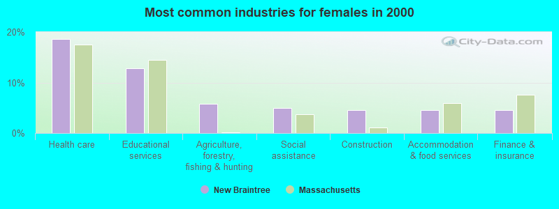
- Health care (18.6%)
- Educational services (12.8%)
- Agriculture, forestry, fishing & hunting (5.8%)
- Social assistance (5.0%)
- Construction (4.5%)
- Accommodation & food services (4.5%)
- Finance & insurance (4.5%)
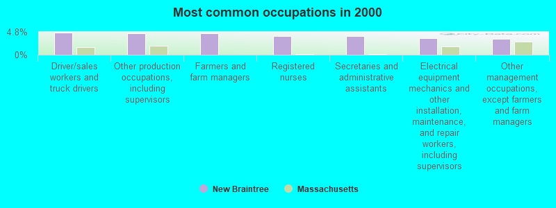
- Driver/sales workers and truck drivers (4.7%)
- Other production occupations, including supervisors (4.5%)
- Farmers and farm managers (4.5%)
- Registered nurses (3.9%)
- Secretaries and administrative assistants (3.9%)
- Electrical equipment mechanics and other installation, maintenance, and repair workers, including supervisors (3.5%)
- Other management occupations, except farmers and farm managers (3.3%)
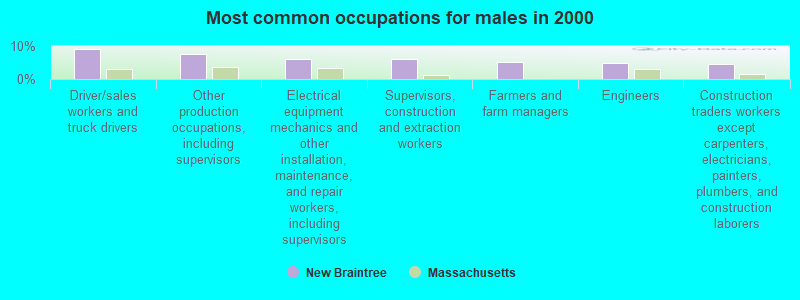
- Driver/sales workers and truck drivers (9.0%)
- Other production occupations, including supervisors (7.5%)
- Electrical equipment mechanics and other installation, maintenance, and repair workers, including supervisors (6.0%)
- Supervisors, construction and extraction workers (6.0%)
- Farmers and farm managers (5.2%)
- Engineers (4.9%)
- Construction traders workers except carpenters, electricians, painters, plumbers, and construction laborers (4.5%)
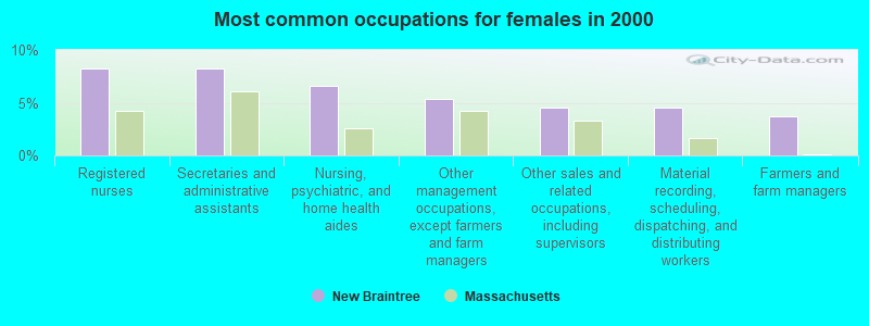
- Registered nurses (8.3%)
- Secretaries and administrative assistants (8.3%)
- Nursing, psychiatric, and home health aides (6.6%)
- Other management occupations, except farmers and farm managers (5.4%)
- Other sales and related occupations, including supervisors (4.5%)
- Material recording, scheduling, dispatching, and distributing workers (4.5%)
- Farmers and farm managers (3.7%)
Average climate in New Braintree, Massachusetts
Based on data reported by over 4,000 weather stations


(lower is better)
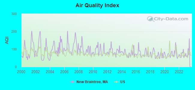
Air Quality Index (AQI) level in 2022 was 69.3. This is about average.
| City: | 69.3 |
| U.S.: | 72.6 |
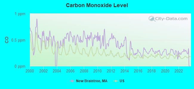
Carbon Monoxide (CO) [ppm] level in 2022 was 0.259. This is about average. Closest monitor was 16.9 miles away from the city center.
| City: | 0.259 |
| U.S.: | 0.251 |
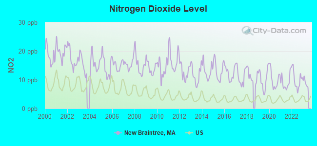
Nitrogen Dioxide (NO2) [ppb] level in 2022 was 10.1. This is significantly worse than average. Closest monitor was 16.0 miles away from the city center.
| City: | 10.1 |
| U.S.: | 5.1 |
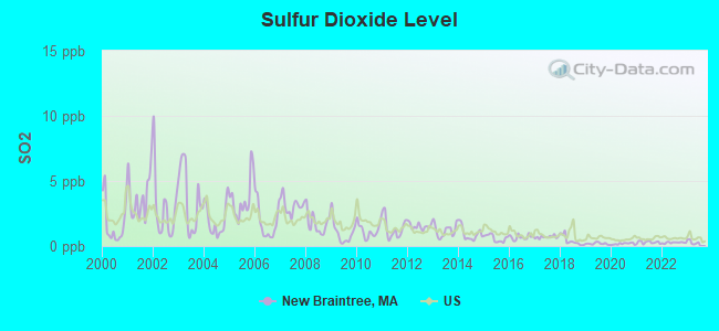
Sulfur Dioxide (SO2) [ppb] level in 2022 was 0.261. This is significantly better than average. Closest monitor was 10.9 miles away from the city center.
| City: | 0.261 |
| U.S.: | 1.515 |
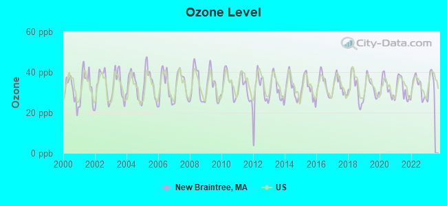
Ozone [ppb] level in 2022 was 32.4. This is about average. Closest monitor was 6.0 miles away from the city center.
| City: | 32.4 |
| U.S.: | 33.3 |
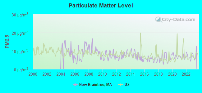
Particulate Matter (PM2.5) [µg/m3] level in 2022 was 7.08. This is about average. Closest monitor was 10.9 miles away from the city center.
| City: | 7.08 |
| U.S.: | 8.11 |
Tornado activity:
New Braintree-area historical tornado activity is above Massachusetts state average. It is 12% smaller than the overall U.S. average.
On 6/9/1953, a category F4 (max. wind speeds 207-260 mph) tornado 10.8 miles away from the New Braintree town center killed 90 people and injured 1228 people and caused between $50,000,000 and $500,000,000 in damages.
On 10/3/1970, a category F3 (max. wind speeds 158-206 mph) tornado 2.6 miles away from the town center killed one person and caused between $50,000 and $500,000 in damages.
Earthquake activity:
New Braintree-area historical earthquake activity is significantly above Massachusetts state average. It is 71% smaller than the overall U.S. average.On 10/7/1983 at 10:18:46, a magnitude 5.3 (5.1 MB, 5.3 LG, 5.1 ML, Class: Moderate, Intensity: VI - VII) earthquake occurred 159.2 miles away from New Braintree center
On 4/20/2002 at 10:50:47, a magnitude 5.3 (5.3 ML, Depth: 3.0 mi) earthquake occurred 171.2 miles away from the city center
On 4/20/2002 at 10:50:47, a magnitude 5.2 (5.2 MB, 4.2 MS, 5.2 MW, 5.0 MW) earthquake occurred 170.2 miles away from the city center
On 1/19/1982 at 00:14:42, a magnitude 4.7 (4.5 MB, 4.7 MD, 4.5 LG, Class: Light, Intensity: IV - V) earthquake occurred 86.0 miles away from the city center
On 10/16/2012 at 23:12:25, a magnitude 4.7 (4.7 ML, Depth: 10.0 mi) earthquake occurred 115.5 miles away from the city center
On 10/2/1994 at 11:27:22, a magnitude 3.7 (3.5 LG, 3.7 LG, Depth: 6.2 mi, Class: Light, Intensity: II - III) earthquake occurred 8.2 miles away from New Braintree center
Magnitude types: regional Lg-wave magnitude (LG), body-wave magnitude (MB), duration magnitude (MD), local magnitude (ML), surface-wave magnitude (MS), moment magnitude (MW)
Natural disasters:
The number of natural disasters in Worcester County (27) is a lot greater than the US average (15).Major Disasters (Presidential) Declared: 15
Emergencies Declared: 12
Causes of natural disasters: Floods: 9, Storms: 8, Hurricanes: 6, Snowstorms: 5, Winter Storms: 4, Blizzards: 2, Snows: 2, Fire: 1, Heavy Rain: 1, Snowfall: 1, Tornado: 1, Wind: 1 (Note: some incidents may be assigned to more than one category).
Hospitals and medical centers near New Braintree:
- GUARDIAN HOSPICE OF MASSACHUSETTS, INC (Hospital, about 6 miles away; WEST BROOKFIELD, MA)
- QUABOAG REHABILITATION AND SKILLED CARE CENTER (Nursing Home, about 6 miles away; WEST BROOKFIELD, MA)
- BAYSTATE MARY LANE HOSPITAL Acute Care Hospitals (about 8 miles away; WARE, MA)
- FAMILY HOME CARE, INC (Home Health Center, about 9 miles away; SPENCER, MA)
- RUTLAND HEIGHTS HOSP- SNF (Nursing Home, about 10 miles away; RUTLAND, MA)
- EDEN HEALTHCARE SERVICES, INC (Home Health Center, about 13 miles away; CHERRY VALLEY, MA)
- KINDRED TRANSITIONAL CARE AND REHAB-THE MEADOWS (Nursing Home, about 14 miles away; ROCHDALE, MA)
Airports located in New Braintree:
- B&b Farm Airport (MA89) (Runways: 1)
Amtrak station near New Braintree:
Colleges/universities with over 2000 students nearest to New Braintree:
- Worcester State University (about 15 miles; Worcester, MA; Full-time enrollment: 5,426)
- Assumption College (about 16 miles; Worcester, MA; FT enrollment: 2,580)
- Clark University (about 16 miles; Worcester, MA; FT enrollment: 3,687)
- Worcester Polytechnic Institute (about 17 miles; Worcester, MA; FT enrollment: 3,930)
- Quinsigamond Community College (about 17 miles; Worcester, MA; FT enrollment: 5,877)
- College of the Holy Cross (about 17 miles; Worcester, MA; FT enrollment: 3,125)
- Mount Wachusett Community College (about 21 miles; Gardner, MA; FT enrollment: 3,143)
Public elementary/middle school in New Braintree:
- NEW BRAINTREE GRADE (Students: 101, Location: 15 MEMORIAL DRIVE, Grades: PK-1)
Points of interest:
Notable locations in New Braintree: Camp Putnam (A), New Braintree Fire Department (B). Display/hide their locations on the map
Church in New Braintree: New Braintree Congregational Church (A). Display/hide its location on the map
Cemeteries: Evergreen Cemetery (1), Hale Cemetery (2), North Cemetery (3), South Cemetery (4). Display/hide their locations on the map
Reservoirs and swamps: Cusky Pond (A), Hall Swamp (B), Meninimisset (C). Display/hide their locations on the map
Streams, rivers, and creeks: Meadow Brook (A), Winimusset Brook (B). Display/hide their locations on the map
Birthplace of: Charles Delano - Politician.
| This town: | 2.7 people |
| Massachusetts: | 2.5 people |
| This town: | 75.1% |
| Whole state: | 63.0% |
| This town: | 8.6% |
| Whole state: | 7.0% |
Likely homosexual households (counted as self-reported same-sex unmarried-partner households)
- Lesbian couples: 0.3% of all households
- Gay men: 0.0% of all households
| This town: | 4.6% |
| Whole state: | 9.3% |
| This town: | 1.0% |
| Whole state: | 4.4% |
For population 15 years and over in New Braintree:
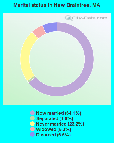
- Never married: 23.2%
- Now married: 64.1%
- Separated: 1.0%
- Widowed: 5.3%
- Divorced: 6.5%
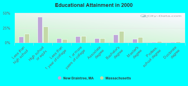
For population 25 years and over in New Braintree:
- High school or higher: 90.0%
- Bachelor's degree or higher: 21.4%
- Graduate or professional degree: 8.0%
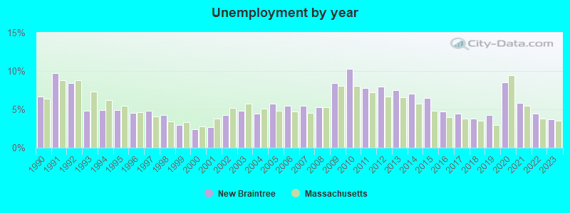
- Unemployed: 3.4%
- Mean travel time to work (commute): 32.8 minutes
| Here: | 9.0 |
| Massachusetts average: | 13.1 |


Graphs represent county-level data. Detailed 2008 Election Results
Religion statistics for New Braintree, MA (based on Worcester County data)


| Religion | Adherents | Congregations |
|---|---|---|
| Catholic | 306,925 | 118 |
| Mainline Protestant | 43,326 | 171 |
| Evangelical Protestant | 37,511 | 203 |
| Other | 18,931 | 69 |
| Orthodox | 7,935 | 15 |
| Black Protestant | 497 | 6 |
| None | 383,427 | - |
Food Environment Statistics:
| Here: | 1.73 / 10,000 pop. |
| Massachusetts: | 1.98 / 10,000 pop. |
| Worcester County: | 0.05 / 10,000 pop. |
| State: | 0.05 / 10,000 pop. |
| This county: | 1.79 / 10,000 pop. |
| Massachusetts: | 2.22 / 10,000 pop. |
| Worcester County: | 2.22 / 10,000 pop. |
| State: | 1.77 / 10,000 pop. |
| This county: | 7.27 / 10,000 pop. |
| Massachusetts: | 8.76 / 10,000 pop. |
| Worcester County: | 8.0% |
| State: | 8.1% |
| Worcester County: | 24.0% |
| State: | 22.5% |
| Here: | 16.6% |
| Massachusetts: | 16.5% |
4.71% of this county's 2021 resident taxpayers lived in other counties in 2020 ($76,229 average adjusted gross income)
| Here: | 4.71% |
| Massachusetts average: | 6.35% |
0.02% of residents moved from foreign countries ($100 average AGI)
Worcester County: 0.02% Massachusetts average: 0.01%
Top counties from which taxpayers relocated into this county between 2020 and 2021:
| from Middlesex County, MA | |
| from Norfolk County, MA | |
| from Suffolk County, MA |
4.84% of this county's 2020 resident taxpayers moved to other counties in 2021 ($87,252 average adjusted gross income)
| Here: | 4.84% |
| Massachusetts average: | 7.18% |
0.03% of residents moved to foreign countries ($199 average AGI)
Worcester County: 0.03% Massachusetts average: 0.02%
Top counties to which taxpayers relocated from this county between 2020 and 2021:
| to Middlesex County, MA | |
| to Norfolk County, MA | |
| to Suffolk County, MA |
Strongest AM radio stations in New Braintree:
- WVNE (760 AM; daytime; 25 kW; LEICESTER, MA; Owner: BLOUNT MASSCOM, INC.)
- WCRN (830 AM; 50 kW; WORCESTER, MA; Owner: CARTER BROADCASTING CORPORATION)
- WARE (1250 AM; 5 kW; WARE, MA; Owner: SUCCESS SIGNAL BROADCASTING, INC.)
- WNNZ (640 AM; 50 kW; WESTFIELD, MA; Owner: CLEAR CHANNEL BROADCASTING LICENSES, INC.)
- WALE (990 AM; 50 kW; GREENVILLE, RI; Owner: NORTH AMERICAN BROADCASTING CO., INC.)
- WTAG (580 AM; 5 kW; WORCESTER, MA; Owner: CAPSTAR TX LIMITED PARTNERSHIP)
- WKOX (1200 AM; 50 kW; FRAMINGHAM, MA; Owner: CAPSTAR TX LIMITED PARTNERSHIP)
- WRKO (680 AM; 50 kW; BOSTON, MA; Owner: ENTERCOM BOSTON LICENSE, LLC)
- WBIX (1060 AM; 40 kW; NATICK, MA; Owner: LANGER BROADCASTING CORPORATION)
- WEEI (850 AM; 50 kW; BOSTON, MA; Owner: ENTERCOM BOSTON LICENSE, LLC)
- WAMG (890 AM; 25 kW; DEDHAM, MA; Owner: MEGA COMMUNICATIONS OF DEDHAM LICENSEE, LLC)
- WTIC (1080 AM; 50 kW; HARTFORD, CT; Owner: INFINITY RADIO OPERATIONS INC.)
- WVEI (1440 AM; 5 kW; WORCESTER, MA; Owner: ENTERCOM BOSTON LICENSE, LLC)
Strongest FM radio stations in New Braintree:
- WAAF (107.3 FM; WORCESTER, MA; Owner: ENTERCOM BOSTON LICENSE, LLC)
- WSRS (96.1 FM; WORCESTER, MA; Owner: CAPSTAR TX LIMITED PARTNERSHIP)
- WFCR (88.5 FM; AMHERST, MA; Owner: UNIVERSITY OF MASSACHUSETTS)
- WAMH (89.3 FM; AMHERST, MA; Owner: TRUSTEES OF AMHERST COLLEGE)
- WBPR (91.9 FM; WORCESTER, MA; Owner: UNIVERSITY OF MASSACHUSETTS)
- W246AM (97.1 FM; AMHERST, MA; Owner: GREAT NORTHERN RADIO, LLC)
- WXLO (104.5 FM; FITCHBURG, MA; Owner: CITADEL BROADCASTING COMPANY)
- WHYN-FM (93.1 FM; SPRINGFIELD, MA; Owner: CLEAR CHANNEL BROADCASTING LICENSES, INC.)
- WRNX (100.9 FM; AMHERST, MA; Owner: WESTERN MASSACHUSETTS RADIO COMPANY)
- WYCM (90.1 FM; CHARLTON, MA; Owner: BAY PATH VOCATIONAL HIGH SCHOOL)
- WFEX (92.1 FM; PETERBOROUGH, NH; Owner: FNX BROADCASTING OF NEW HAMPSHIRE LLC)
- WAHL (99.9 FM; ATHOL, MA; Owner: CITADEL BROADCASTING COMPANY)
- WAMC-FM (90.3 FM; ALBANY, NY; Owner: WAMC)
- WWFX (100.1 FM; SOUTHBRIDGE, MA; Owner: CITADEL BROADCASTING COMPANY)
- WICN (90.5 FM; WORCESTER, MA; Owner: WICN PUBLIC RADIO, INC)
- WORC-FM (98.9 FM; WEBSTER, MA; Owner: CITADEL BROADCASTING COMPANY)
- WBMX (98.5 FM; BOSTON, MA; Owner: INFINITY RADIO OPERATIONS INC.)
- WAQY (102.1 FM; SPRINGFIELD, MA; Owner: SAGA COMMUNICATIONS OF NEW ENGLAND, LLC)
- WJMN (94.5 FM; BOSTON, MA; Owner: AMFM RADIO LICENSES, L.L.C.)
- WCRB (102.5 FM; WALTHAM, MA; Owner: CHARLES RIVER BROADCASTING WCRB LICE)
TV broadcast stations around New Braintree:
- WYDN (Channel 48; WORCESTER, MA; Owner: EDUCATIONAL PUBLIC TV CORPORATION)
- WUNI (Channel 27; WORCESTER, MA; Owner: ENTRAVISION HOLDINGS, LLC)
- WUTF (Channel 66; MARLBOROUGH, MA; Owner: TELEFUTURA BOSTON LLC)
- WCVB-TV (Channel 5; BOSTON, MA; Owner: WCVB HEARST-ARGYLE TV, INC.)
- WGBH-TV (Channel 2; BOSTON, MA; Owner: WGBH EDUCATIONAL FOUNDATION)
- WCRN-LP (Channel 34; LEICESTER, MA; Owner: CARTER BROADCASTING CORPORATION)
- WMFP (Channel 62; LAWRENCE, MA; Owner: WSAH LICENSE, INC.)
- WTIC-TV (Channel 61; HARTFORD, CT; Owner: TRIBUNE TELEVISION COMPANY)
- WBZ-TV (Channel 4; BOSTON, MA; Owner: VIACOM INC.)
- WGBX-TV (Channel 44; BOSTON, MA; Owner: WGBH EDUCATIONAL FOUNDATION)
- WSBK-TV (Channel 38; BOSTON, MA; Owner: VIACOM INC.)
- WLVI-TV (Channel 56; CAMBRIDGE, MA; Owner: WLVI, INC.)
- WFXT (Channel 25; BOSTON, MA; Owner: FOX TELEVISION STATIONS INC.)
- WPXQ (Channel 69; BLOCK ISLAND, RI; Owner: OCEAN STATE TELEVISION, L.L.C.)
- New Braintree, Massachusetts
- Fatal accident count8
- Vehicles involved in fatal accidents11
- Fatal accidents involving drunk persons:5
- Fatalities9
- Persons involved in fatal accidents17
- Pedestrians involved in fatal accidents0
- Massachusetts average
- Fatal accident count3580
- Vehicles involved in fatal accidents5119
- Fatal accidents involving drunk persons1111
- Fatalities3812
- Persons involved in fatal accidents8270
- Pedestrians involved in fatal accidents660
- National Bridge Inventory (NBI) Statistics
- 3Number of bridges
- 13ft / 3.5mTotal length
- $3,786,000Total costs
- 1,860Total average daily traffic
- 80Total average daily truck traffic
- 1,416Total future (year 2031) average daily traffic
FCC Registered Antenna Towers:
9 (See the full list of FCC Registered Antenna Towers in New Braintree)FCC Registered Broadcast Land Mobile Towers:
3- NEW BRAINTREE, Circle Dr (Lat: 42.311750 Lon: -72.135333), Type: Ltower, Structure height: 68.6 m, Overall height: 76.2 m, Call Sign: WQVH972,
Assigned Frequencies: 155.752 MHz, 158.737 MHz, 159.472 MHz, Grant Date: 02/18/2015, Expiration Date: 02/18/2025, Certifier: Charles B Sutherland, Registrant: New Wave Licensing Services Inc., 517 Sachs Road, Gettysburg, PA 17325, Phone: (717) 334-0910, Fax: (717) 334-4736, Email:
- Lat: 42.313694 Lon: -72.128722, Call Sign: WROX294,
Assigned Frequencies: 158.752 MHz, Grant Date: 12/23/2021, Expiration Date: 12/23/2031, Certifier: Richard Ayer, Registrant: Business Radio Licensing, 30251 Golden Lantern, Suite E, Laguna Niguel, CA 92677, Phone: (949) 348-8510, Fax: (949) 348-8514, Email:
- PUMP HOUSE, 460 West Rd (Lat: 42.313583 Lon: -72.151444), Type: Bant, Structure height: 6.1 m, Overall height: 7.6 m, Call Sign: WRZM575,
Assigned Frequencies: 218.025 MHz, Grant Date: 11/18/2023, Expiration Date: 11/18/2033, Certifier: Matthew Barstow, Registrant: Jwb Company, 65 August Ave, Wolcott, CT 06716, Phone: (203) 879-6959, Fax: (203) 879-7299, Email:
FCC Registered Microwave Towers:
4- NEW BRAINTRE, Brookfiled Rd-Massachusetts State Police Training Academy (Lat: 42.311722 Lon: -72.135472), Type: Building, Structure height: 76.2 m, Call Sign: WPOR400,
Assigned Frequencies: 953.550 MHz, 11133.1 MHz, Grant Date: 10/30/2018, Expiration Date: 12/31/2028, Registrant: Massachusetts State Police, 470 Worchester Rd, Framingham, MA 01701, Phone: (508) 820-2222, Email:
- NEW BRAINTREE, Circle Drive (Lat: 42.311722 Lon: -72.135472), Type: Mast, Structure height: 68.6 m, Overall height: 76.2 m, Call Sign: WPQX341,
Assigned Frequencies: 6397.38 MHz, Grant Date: 12/07/2010, Expiration Date: 11/02/2020, Cancellation Date: 08/24/2012, Certifier: Carol L Tacker, Registrant: At&t Mobility LLC, 5601 Legacy Drive, Ms: A-3, Plano, TX 75024, Phone: (469) 229-7471, Fax: (469) 229-7297, Email:
- MSP, Circle Dr (Lat: 42.311750 Lon: -72.135333), Type: Tower, Structure height: 68.6 m, Overall height: 76.2 m, Call Sign: WPZB203,
Assigned Frequencies: 955.550 MHz, Grant Date: 10/06/2023, Expiration Date: 12/17/2033, Certifier: C. Blair Sutherland, Registrant: Massachusetts, Commonwealth Of Department Of State Police, 470 Worcester Rd, Framingham, MA 01702, Phone: (508) 820-2222, Email:
- NEW BRAINTREE CSUB D, 340 W Brookfield Rd (Lat: 42.309861 Lon: -72.134667), Type: Building, Structure height: 7 m, Call Sign: WSBR908,
Assigned Frequencies: 10815.0 MHz, Grant Date: 03/07/2024, Expiration Date: 03/07/2034, Certifier: Matthew M Barstow, Registrant: Massachusetts, Commonwealth Of, 470 Worcester Rd, Framingham, MA 01702, Phone: (508) 820-2264, Email:
FCC Registered Amateur Radio Licenses:
9 (See the full list of FCC Registered Amateur Radio Licenses in New Braintree)FAA Registered Aircraft Manufacturers and Dealers:
1- AIRWEST INC, 258 Mcevoy Rd, New Braintree, MA 01531
Certificate: 03-0858 (Corporation), Certificate Issue Date: 05/08/2003, Expiration Date: 05/07/2004
FAA Registered Aircraft:
2- Aircraft: SIX CHUTER INC SR7 XL (Category: Land, Seats: 2, Weight: Up to 12,499 Pounds), Engine: ROTAX 582SER (65 HP) (2 Cycle)
N-Number: 327MK, N327MK, N-327MK, Serial Number: 99-2232-SR7X1, Year manufactured: 1999, Airworthiness Date: 10/21/2007, Certificate Issue Date: 10/25/2006
Registrant (Individual): Michael J Klem, 122 Igoe Rd, New Braintree, MA 01531 - Aircraft: CESSNA 150G (Category: Land, Seats: 2, Weight: Up to 12,499 Pounds, Speed: 90 mph), Engine: CONT MOTOR 0-200 SERIES (100 HP) (4 Cycle)
N-Number: 3333J, N3333J, N-3333J, Serial Number: 15066033, Year manufactured: 1966, Airworthiness Date: 02/21/1967, Certificate Issue Date: 10/11/2016
Registrant (Individual): Harry J Andrews, 716 Hardwick Rd, New Braintree, MA 01531
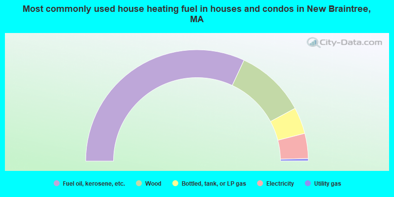
- 63.9%Fuel oil, kerosene, etc.
- 20.4%Wood
- 7.7%Bottled, tank, or LP gas
- 7.3%Electricity
- 0.7%Utility gas
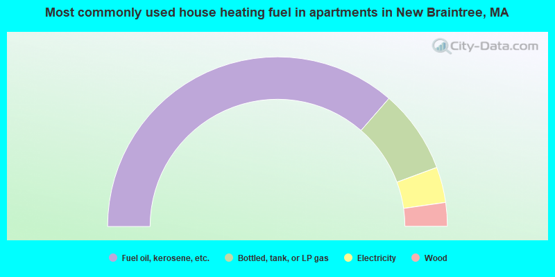
- 72.7%Fuel oil, kerosene, etc.
- 15.9%Bottled, tank, or LP gas
- 6.8%Electricity
- 4.5%Wood
New Braintree compared to Massachusetts state average:
- Unemployed percentage significantly below state average.
- Black race population percentage significantly below state average.
- Hispanic race population percentage significantly below state average.
- Median age above state average.
- Foreign-born population percentage significantly below state average.
- Renting percentage significantly below state average.
- Length of stay since moving in significantly above state average.
- Number of rooms per house significantly below state average.
- House age significantly below state average.
- Percentage of population with a bachelor's degree or higher below state average.

|
Total of 4 patent applications in 2008-2024.