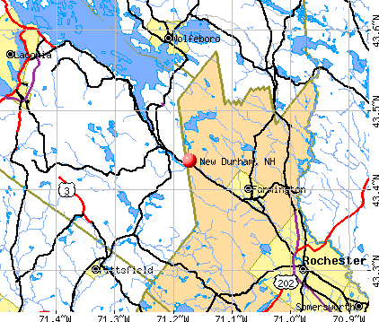
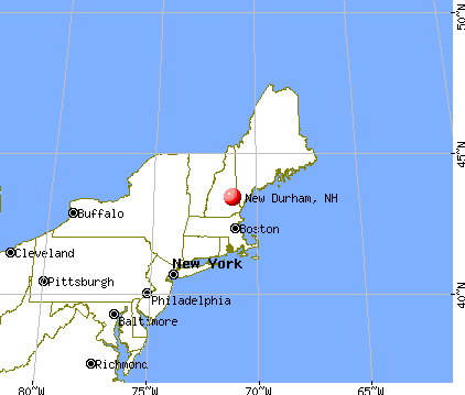
New Durham, New Hampshire
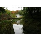
New Durham: Fish Hatchery on Merry Meeting River
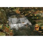
New Durham: Fish Hatchery
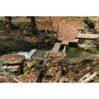
New Durham: Fish Hatchery
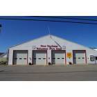
New Durham: New Durham Fire Dept
- add
your
Submit your own pictures of this town and show them to the world
- OSM Map
- General Map
- Google Map
- MSN Map
Population change since 2000: +18.8%
 |
| Males: 1,348 | |
| Females: 1,290 |
| Median resident age: | 43.7 years |
| New Hampshire median age: | 43.9 years |
Zip codes: 03855.
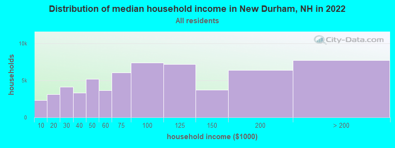
| New Durham: | $96,972 |
| NH: | $89,992 |
Estimated per capita income in 2022: $48,038 (it was $22,139 in 2000)
New Durham town income, earnings, and wages data
Estimated median house or condo value in 2022: $361,346 (it was $116,600 in 2000)
| New Durham: | $361,346 |
| NH: | $384,700 |
Mean prices in 2022: all housing units: $372,213; detached houses: $404,882; townhouses or other attached units: $390,591; in 2-unit structures: $310,268; in 3-to-4-unit structures: $385,130; in 5-or-more-unit structures: $243,262; mobile homes: $123,219
Detailed information about poverty and poor residents in New Durham, NH


- 2,57297.5%White alone
- 281.1%Two or more races
- 220.8%Hispanic
- 80.3%Asian alone
- 40.2%Black alone
- 20.08%American Indian alone
- 20.08%Other race alone
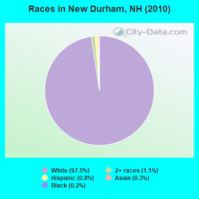
Races in New Durham detailed stats: ancestries, foreign born residents, place of birth
According to our research of New Hampshire and other state lists, there were 9 registered sex offenders living in New Durham, New Hampshire as of May 17, 2024.
The ratio of all residents to sex offenders in New Durham is 293 to 1.
Type |
2009 |
2010 |
2011 |
2012 |
2013 |
2014 |
2015 |
2016 |
2017 |
2018 |
2019 |
2020 |
2021 |
2022 |
|---|---|---|---|---|---|---|---|---|---|---|---|---|---|---|
| Murders (per 100,000) | 0 (0.0) | 0 (0.0) | 0 (0.0) | 0 (0.0) | 0 (0.0) | 0 (0.0) | 0 (0.0) | 0 (0.0) | 0 (0.0) | 0 (0.0) | 0 (0.0) | 0 (0.0) | 0 (0.0) | 0 (0.0) |
| Rapes (per 100,000) | 1 (38.6) | 0 (0.0) | 0 (0.0) | 0 (0.0) | 2 (75.4) | 3 (113.1) | 2 (75.1) | 0 (0.0) | 1 (37.4) | 1 (37.3) | 0 (0.0) | 0 (0.0) | 0 (0.0) | 0 (0.0) |
| Robberies (per 100,000) | 0 (0.0) | 0 (0.0) | 0 (0.0) | 0 (0.0) | 0 (0.0) | 0 (0.0) | 0 (0.0) | 0 (0.0) | 0 (0.0) | 0 (0.0) | 0 (0.0) | 0 (0.0) | 0 (0.0) | 0 (0.0) |
| Assaults (per 100,000) | 5 (193.1) | 4 (151.6) | 3 (113.6) | 4 (150.4) | 0 (0.0) | 3 (113.1) | 5 (187.8) | 4 (150.3) | 1 (37.4) | 5 (186.6) | 3 (110.9) | 1 (36.8) | 3 (108.3) | 0 (0.0) |
| Burglaries (per 100,000) | 10 (386.1) | 11 (417.0) | 15 (568.0) | 18 (676.9) | 6 (226.2) | 13 (490.0) | 4 (150.2) | 5 (187.8) | 3 (112.3) | 5 (186.6) | 3 (110.9) | 5 (184.2) | 1 (36.1) | 5 (180.8) |
| Thefts (per 100,000) | 22 (849.4) | 30 (1,137) | 64 (2,423) | 28 (1,053) | 52 (1,961) | 30 (1,131) | 18 (675.9) | 16 (601.1) | 15 (561.6) | 31 (1,157) | 19 (702.7) | 17 (626.2) | 14 (505.2) | 31 (1,121) |
| Auto thefts (per 100,000) | 5 (193.1) | 2 (75.8) | 0 (0.0) | 0 (0.0) | 3 (113.1) | 4 (150.8) | 1 (37.6) | 1 (37.6) | 0 (0.0) | 10 (373.1) | 2 (74.0) | 3 (110.5) | 3 (108.3) | 1 (36.2) |
| Arson (per 100,000) | 1 (38.6) | 1 (37.9) | 0 (0.0) | 0 (0.0) | 0 (0.0) | 0 (0.0) | 0 (0.0) | 0 (0.0) | 0 (0.0) | 1 (37.3) | 2 (74.0) | 1 (36.8) | 1 (36.1) | 0 (0.0) |
| City-Data.com crime index | 145.9 | 111.1 | 159.4 | 119.6 | 163.7 | 204.7 | 138.2 | 70.2 | 67.8 | 156.3 | 64.0 | 54.1 | 53.0 | 60.4 |
The City-Data.com crime index weighs serious crimes and violent crimes more heavily. Higher means more crime, U.S. average is 246.1. It adjusts for the number of visitors and daily workers commuting into cities.
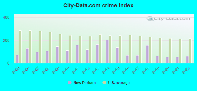
Crime rate in New Durham detailed stats: murders, rapes, robberies, assaults, burglaries, thefts, arson
Full-time law enforcement employees in 2021, including police officers: 5 (5 officers - 5 male; 0 female).
| Officers per 1,000 residents here: | 1.80 |
| New Hampshire average: | 2.14 |
 Recent articles from our blog. Our writers, many of them Ph.D. graduates or candidates, create easy-to-read articles on a wide variety of topics.

 | Thinking of Moving my Family to New Hampshire. Looking for Thoughts from Residents. (21 replies) |
| Thinking of moving to New Hampshire from WA (40 replies) |
| Relocating to rural New England (18 replies) |
| Wanting to relocate w/ Rent to Own (5 replies) |
| NH job opportunities (1 reply) |
| Reputation of towns in the Lakes Region? (28 replies) |
Latest news from New Durham, NH collected exclusively by city-data.com from local newspapers, TV, and radio stations
Ancestries: English (20.0%), French (17.9%), Irish (17.3%), United States (11.6%), German (8.0%), French Canadian (7.6%).
Current Local Time: EST time zone
Incorporated in 1762
Elevation: 541 feet
Land area: 41.7 square miles.
Population density: 63 people per square mile (very low).
29 residents are foreign born
| This town: | 1.3% |
| New Hampshire: | 4.4% |
| New Durham town: | 2.2% ($2,606) |
| New Hampshire: | 2.3% ($2,946) |
Nearest city with pop. 50,000+: Manchester, NH  (35.2 miles , pop. 107,006).
Nearest city with pop. 200,000+: Boston, MA (77.7 miles , pop. 589,141).
Nearest city with pop. 1,000,000+: Bronx, NY (227.6 miles , pop. 1,332,650).
Nearest cities:
), ), ), )Latitude: 43.44 N, Longitude: 71.15 W
Area code: 603

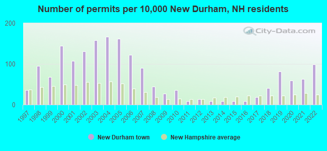
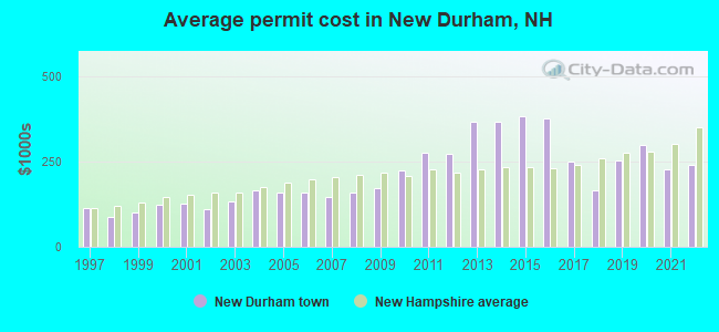
Single-family new house construction building permits:
- 2022: 22 buildings, average cost: $240,400
- 2021: 14 buildings, average cost: $227,500
- 2020: 13 buildings, average cost: $300,000
- 2019: 18 buildings, average cost: $253,100
- 2018: 9 buildings, average cost: $167,000
- 2017: 4 buildings, average cost: $250,000
- 2016: 2 buildings, average cost: $376,800
- 2015: 2 buildings, average cost: $384,500
- 2014: 2 buildings, average cost: $369,000
- 2013: 2 buildings, average cost: $369,000
- 2012: 3 buildings, average cost: $274,000
- 2011: 2 buildings, average cost: $275,000
- 2010: 8 buildings, average cost: $224,500
- 2009: 6 buildings, average cost: $173,000
- 2008: 10 buildings, average cost: $159,100
- 2007: 20 buildings, average cost: $147,400
- 2006: 27 buildings, average cost: $158,800
- 2005: 36 buildings, average cost: $161,200
- 2004: 37 buildings, average cost: $167,000
- 2003: 35 buildings, average cost: $132,100
- 2002: 29 buildings, average cost: $110,500
- 2001: 24 buildings, average cost: $126,100
- 2000: 32 buildings, average cost: $125,300
- 1999: 15 buildings, average cost: $100,600
- 1998: 21 buildings, average cost: $86,500
- 1997: 8 buildings, average cost: $114,100
| Here: | 2.0% |
| New Hampshire: | 2.5% |
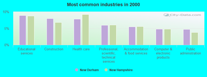
- Educational services (8.9%)
- Construction (8.0%)
- Health care (7.8%)
- Professional, scientific, technical services (6.0%)
- Accommodation & food services (5.5%)
- Computer & electronic products (4.8%)
- Public administration (4.7%)
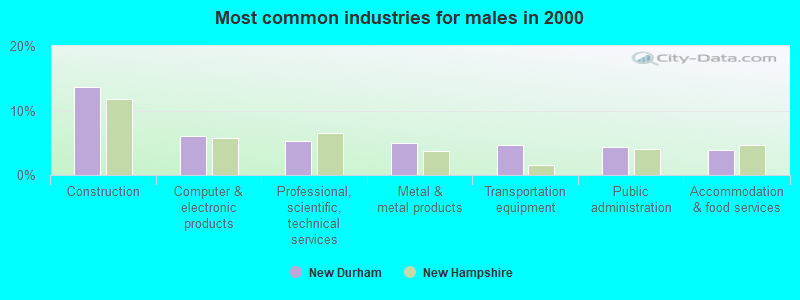
- Construction (13.7%)
- Computer & electronic products (6.1%)
- Professional, scientific, technical services (5.3%)
- Metal & metal products (5.0%)
- Transportation equipment (4.7%)
- Public administration (4.4%)
- Accommodation & food services (4.0%)
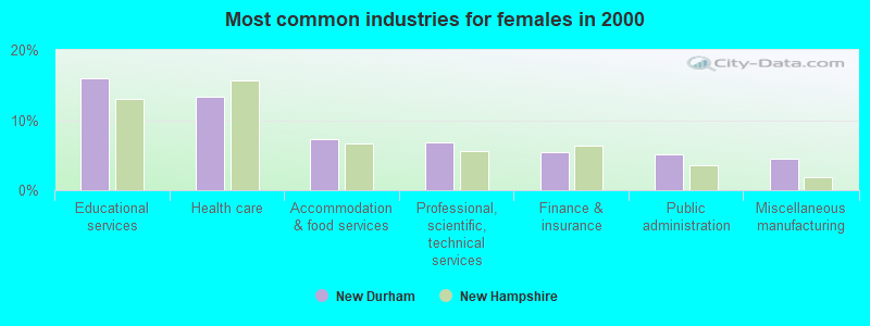
- Educational services (16.0%)
- Health care (13.4%)
- Accommodation & food services (7.3%)
- Professional, scientific, technical services (6.8%)
- Finance & insurance (5.5%)
- Public administration (5.1%)
- Miscellaneous manufacturing (4.5%)
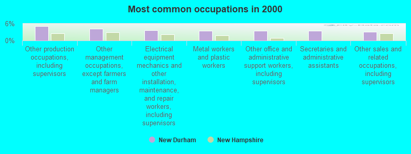
- Other production occupations, including supervisors (5.1%)
- Other management occupations, except farmers and farm managers (4.2%)
- Electrical equipment mechanics and other installation, maintenance, and repair workers, including supervisors (3.7%)
- Metal workers and plastic workers (3.5%)
- Other office and administrative support workers, including supervisors (3.4%)
- Secretaries and administrative assistants (3.4%)
- Other sales and related occupations, including supervisors (3.1%)
- Electrical equipment mechanics and other installation, maintenance, and repair workers, including supervisors (6.1%)
- Metal workers and plastic workers (5.6%)
- Driver/sales workers and truck drivers (4.9%)
- Other management occupations, except farmers and farm managers (4.6%)
- Other production occupations, including supervisors (4.4%)
- Retail sales workers, except cashiers (4.4%)
- Engineers (3.8%)
- Secretaries and administrative assistants (7.0%)
- Preschool, kindergarten, elementary, and middle school teachers (6.2%)
- Other production occupations, including supervisors (6.0%)
- Other office and administrative support workers, including supervisors (4.9%)
- Other sales and related occupations, including supervisors (4.1%)
- Registered nurses (4.0%)
- Waiters and waitresses (3.8%)
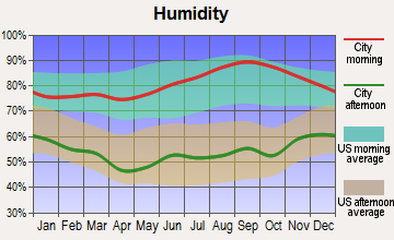
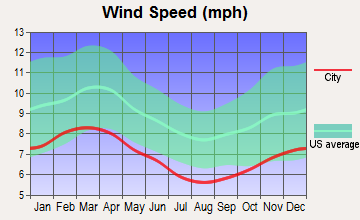
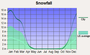
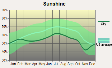
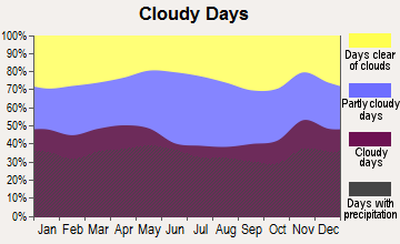
Average climate in New Durham, New Hampshire
Based on data reported by over 4,000 weather stations
(lower is better)
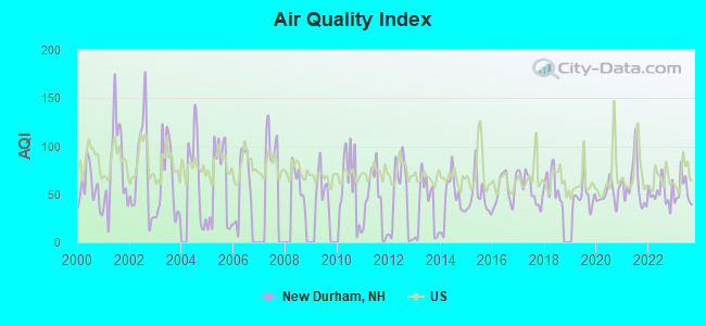
Air Quality Index (AQI) level in 2023 was 53.1. This is better than average.
| City: | 53.1 |
| U.S.: | 72.6 |
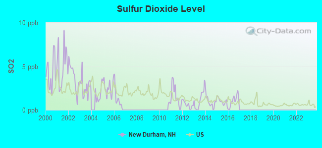
Sulfur Dioxide (SO2) [ppb] level in 2016 was 1.05. This is significantly better than average. Closest monitor was 19.4 miles away from the city center.
| City: | 1.05 |
| U.S.: | 1.51 |
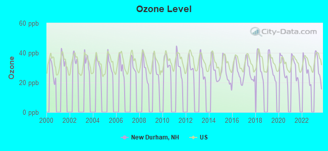
Ozone [ppb] level in 2023 was 30.2. This is about average. Closest monitor was 15.5 miles away from the city center.
| City: | 30.2 |
| U.S.: | 33.3 |
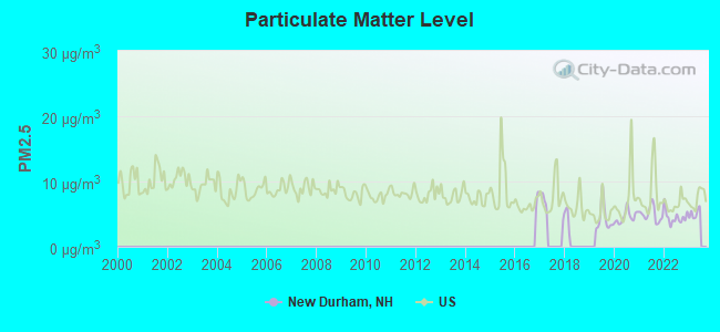
Particulate Matter (PM2.5) [µg/m3] level in 2022 was 4.52. This is significantly better than average. Closest monitor was 16.3 miles away from the city center.
| City: | 4.52 |
| U.S.: | 8.11 |
Tornado activity:
New Durham-area historical tornado activity is near New Hampshire state average. It is 59% smaller than the overall U.S. average.
On 6/22/1981, a category F2 (max. wind speeds 113-157 mph) tornado 1.5 miles away from the New Durham town center caused between $500,000 and $5,000,000 in damages.
On 6/9/1953, a category F3 (max. wind speeds 158-206 mph) tornado 33.9 miles away from the town center injured 5 people and caused between $5000 and $50,000 in damages.
Earthquake activity:
New Durham-area historical earthquake activity is significantly above New Hampshire state average. It is 72% smaller than the overall U.S. average.On 4/20/2002 at 10:50:47, a magnitude 5.3 (5.3 ML, Depth: 3.0 mi, Class: Moderate, Intensity: VI - VII) earthquake occurred 146.9 miles away from the city center
On 1/19/1982 at 00:14:42, a magnitude 4.7 (4.5 MB, 4.7 MD, 4.5 LG, Class: Light, Intensity: IV - V) earthquake occurred 23.1 miles away from the city center
On 10/16/2012 at 23:12:25, a magnitude 4.7 (4.7 ML, Depth: 10.0 mi) earthquake occurred 26.8 miles away from New Durham center
On 10/7/1983 at 10:18:46, a magnitude 5.3 (5.1 MB, 5.3 LG, 5.1 ML) earthquake occurred 163.6 miles away from New Durham center
On 4/20/2002 at 10:50:47, a magnitude 5.2 (5.2 MB, 4.2 MS, 5.2 MW, 5.0 MW) earthquake occurred 147.0 miles away from the city center
On 8/21/1996 at 07:54:14, a magnitude 3.8 (3.8 LG, 3.6 LG, Depth: 6.2 mi, Class: Light, Intensity: II - III) earthquake occurred 52.2 miles away from the city center
Magnitude types: regional Lg-wave magnitude (LG), body-wave magnitude (MB), duration magnitude (MD), local magnitude (ML), surface-wave magnitude (MS), moment magnitude (MW)
Natural disasters:
The number of natural disasters in Strafford County (23) is greater than the US average (15).Major Disasters (Presidential) Declared: 14
Emergencies Declared: 8
Causes of natural disasters: Storms: 8, Floods: 6, Winter Storms: 6, Snowstorms: 5, Hurricanes: 3, Blizzard: 1, Ice Storm: 1, Snow: 1, Snowfall: 1, Tornado: 1, Tropical Storm: 1, Wind: 1, Other: 1 (Note: some incidents may be assigned to more than one category).

Hospitals and medical centers near New Durham:
- YOUR VNA (Home Health Center, about 10 miles away; ROCHESTER, NH)
- WOLFEBORO BAY CARE AND REHABILITATION CENTER (Nursing Home, about 10 miles away; WOLFEBORO, NH)
- HUGGINS HOSPITAL Critical Access Hospitals (about 10 miles away; WOLFEBORO, NH)
- VNA HOSPICE OF S CARROLL CO AND VICINITY (Hospital, about 10 miles away; WOLFEBORO, NH)
- ACADEMY NH INC (Nursing Home, about 14 miles away; ROCHESTER, NH)
- FRISBIE MEMORIAL HOSPITAL Acute Care Hospitals (about 14 miles away; ROCHESTER, NH)
- ROCHESTER MANOR (Nursing Home, about 14 miles away; ROCHESTER, NH)
located in New Durham:
Colleges/universities with over 2000 students nearest to New Durham:
- University of New Hampshire-Main Campus (about 24 miles; Durham, NH; Full-time enrollment: 15,243)
- NHTI-Concord's Community College (about 25 miles; Concord, NH; FT enrollment: 2,865)
- Southern New Hampshire University (about 32 miles; Manchester, NH; FT enrollment: 16,552)
- Plymouth State University (about 35 miles; Plymouth, NH; FT enrollment: 4,838)
- Mount Washington College (about 37 miles; Manchester, NH; FT enrollment: 2,187)
- Saint Anselm College (about 37 miles; Manchester, NH; FT enrollment: 2,059)
- University of New England (about 39 miles; Biddeford, ME; FT enrollment: 4,539)
Public elementary/middle school in New Durham:
- NEW DURHAM ELEMENTARY SCHOOL (Students: 194, Location: 7 OLD BAY RD., Grades: PK-6)
Points of interest:
Notable locations in New Durham: Powder Mill Fish Hatchery (A), Birch Hill Camp (B), New Durham Fire Department (C), New Durham Public Library (D), New Durham Town Hall (E). Display/hide their locations on the map
Churches in New Durham include: New Durham Meetinghouse (A), Free Will Baptist Church (B). Display/hide their locations on the map
Lakes and reservoirs: Chalk Pond (A), Club Pond (B), Coldrain Pond (C), Marchs Pond (D), Marsh Pond (E), Shaws Pond (F), Jones Pond (G), Downing Pond (H). Display/hide their locations on the map
Park in New Durham: Jones Brook Wildlife Management Area (1). Display/hide its location on the map
Drinking water stations with addresses in New Durham and their reported violations in the past:
STRAFFORD INN (Population served: 90, Groundwater):Past monitoring violations:MANITOOS SHORES (Population served: 57, Groundwater):
- Failure To Address Deficiency - In FEB-15-2013, Contaminant: GROUNDWATER RULE. Follow-up actions: St Public Notif requested (MAR-05-2013), St Formal NOV issued (MAR-05-2013), St Compliance achieved (APR-23-2013), St Public Notif received (MAY-10-2013)
- 4 routine major monitoring violations
Past health violations:
- OCCT/SOWT Study/Recommendation - In JUN-01-2010, Contaminant: Lead and Copper Rule. Follow-up actions: St Public Notif requested (JUN-04-2010), St Violation/Reminder Notice (JUN-04-2010), St Compliance achieved (JUN-23-2010), St Public Notif received (JUN-29-2010)
| This town: | 2.6 people |
| New Hampshire: | 2.5 people |
| This town: | 74.7% |
| Whole state: | 66.3% |
| This town: | 9.5% |
| Whole state: | 8.3% |
Likely homosexual households (counted as self-reported same-sex unmarried-partner households)
- Lesbian couples: 0.2% of all households
- Gay men: 0.4% of all households
| This town: | 5.1% |
| Whole state: | 6.5% |
| This town: | 2.7% |
| Whole state: | 2.8% |
For population 15 years and over in New Durham:
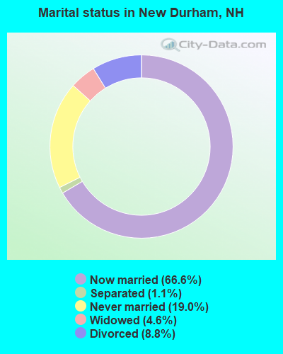
- Never married: 19.0%
- Now married: 66.6%
- Separated: 1.1%
- Widowed: 4.6%
- Divorced: 8.8%
For population 25 years and over in New Durham:
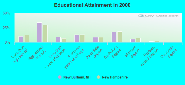
- High school or higher: 90.0%
- Bachelor's degree or higher: 24.9%
- Graduate or professional degree: 7.4%
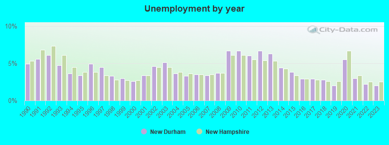
- Unemployed: 2.1%
- Mean travel time to work (commute): 35.9 minutes
| Here: | 9.4 |
| New Hampshire average: | 10.9 |
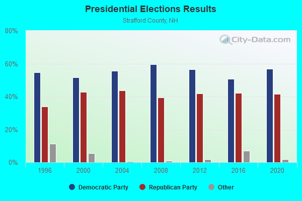
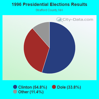
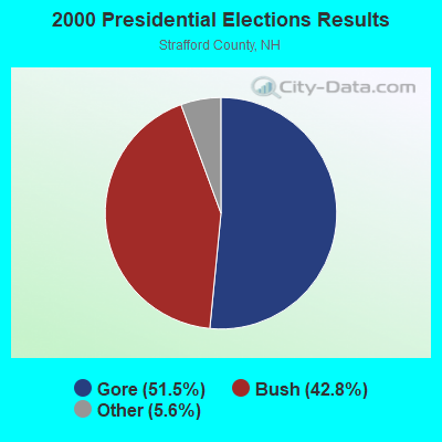
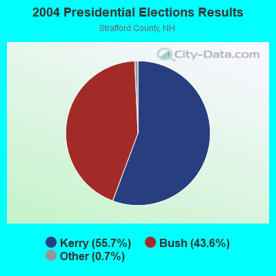
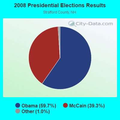
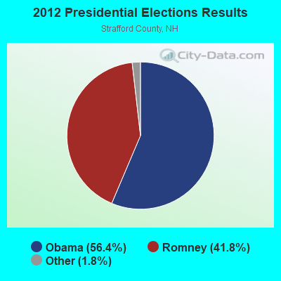
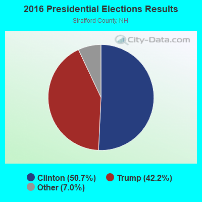
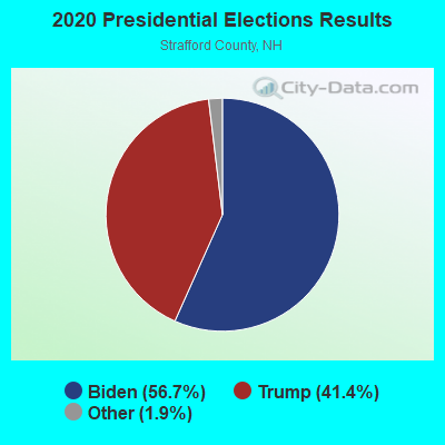
Graphs represent county-level data. Detailed 2008 Election Results
Religion statistics for New Durham, NH (based on Strafford County data)
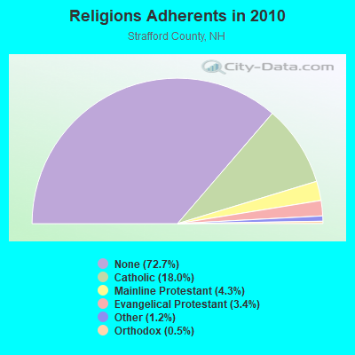
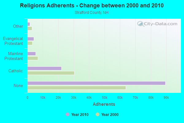
| Religion | Adherents | Congregations |
|---|---|---|
| Catholic | 22,112 | 11 |
| Mainline Protestant | 5,299 | 21 |
| Evangelical Protestant | 4,143 | 37 |
| Other | 1,504 | 13 |
| Orthodox | 575 | 2 |
| None | 89,510 | - |
Food Environment Statistics:
| Here: | 1.73 / 10,000 pop. |
| New Hampshire: | 2.14 / 10,000 pop. |
| This county: | 0.08 / 10,000 pop. |
| New Hampshire: | 0.15 / 10,000 pop. |
| Here: | 2.48 / 10,000 pop. |
| New Hampshire: | 1.78 / 10,000 pop. |
| Strafford County: | 3.80 / 10,000 pop. |
| New Hampshire: | 4.02 / 10,000 pop. |
| Strafford County: | 8.17 / 10,000 pop. |
| New Hampshire: | 9.70 / 10,000 pop. |
| This county: | 8.8% |
| State: | 7.6% |
| This county: | 26.2% |
| State: | 24.4% |
| Strafford County: | 14.0% |
| New Hampshire: | 15.9% |
Strongest AM radio stations in New Durham:
- WGIN (930 AM; 10 kW; ROCHESTER, NH; Owner: CAPSTAR TX LIMITED PARTNERSHIP)
- WASR (1420 AM; 5 kW; WOLFEBORO, NH; Owner: RADIO WOLFEBORO, INC.)
- WRKO (680 AM; 50 kW; BOSTON, MA; Owner: ENTERCOM BOSTON LICENSE, LLC)
- WEZS (1350 AM; 5 kW; LACONIA, NH; Owner: GARY W. HAMMOND)
- WEEI (850 AM; 50 kW; BOSTON, MA; Owner: ENTERCOM BOSTON LICENSE, LLC)
- WMTW (870 AM; 10 kW; GORHAM, ME; Owner: RADIO PARTNERS OF MAINE, L.P.)
- WTSN (1270 AM; 5 kW; DOVER, NH; Owner: GARRISON CITY BROADCASTING, INC.)
- WBZ (1030 AM; 50 kW; BOSTON, MA; Owner: INFINITY BROADCASTING OPERATIONS, INC.)
- WCRN (830 AM; 50 kW; WORCESTER, MA; Owner: CARTER BROADCASTING CORPORATION)
- WGIR (610 AM; 5 kW; MANCHESTER, NH; Owner: CAPSTAR TX LIMITED PARTNERSHIP)
- WKOX (1200 AM; 50 kW; FRAMINGHAM, MA; Owner: CAPSTAR TX LIMITED PARTNERSHIP)
- WWZN (1510 AM; 50 kW; BOSTON, MA; Owner: ROSE CITY RADIO CORPORATION)
- WBIX (1060 AM; 40 kW; NATICK, MA; Owner: LANGER BROADCASTING CORPORATION)
Strongest FM radio stations in New Durham:
- WMEX (106.5 FM; FARMINGTON, NH; Owner: WIMMEX, LLC)
- WLKZ (104.9 FM; WOLFEBORO, NH; Owner: TELE-MEDIA COMPANY OF NEW HAMPSHIRE, L.L.C.)
- WSCY (106.9 FM; MOULTONBOROUGH, NH; Owner: NORTHEAST COMMUNICATIONS CORPORATION)
- WNHI (93.3 FM; BELMONT, NH; Owner: CONCORD BROADCASTING, L.L.C.)
- WPKQ (103.7 FM; NORTH CONWAY, NH; Owner: CITADEL BROADCASTING COMPANY)
- WHOM (94.9 FM; MT. WASHINGTON, NH; Owner: CITADEL BROADCASTING COMPANY)
- WMEA (90.1 FM; PORTLAND, ME; Owner: MAINE PUBLIC BROADCASTING CORPORATION)
- WVFM (105.7 FM; CAMPTON, NH; Owner: DEVON BROADCASTING COMPANY, INC.)
- WPHX-FM (92.1 FM; SANFORD, ME; Owner: FNX BROADCASTING LLC)
- WSEW (88.5 FM; SANFORD, ME; Owner: WORD RADIO EDUCATIONAL FOUNDATION)
- WOKQ (97.5 FM; DOVER, NH; Owner: CITADEL BROADCASTING COMPANY)
- WHDQ (106.1 FM; CLAREMONT, NH; Owner: GREAT NORTHERN RADIO, L.L.C.)
- WPNH-FM (100.1 FM; PLYMOUTH, NH; Owner: NORTHEAST COMMUNICATIONS CORPORATION)
- W282AF (104.3 FM; CONCORD, NH; Owner: CONCORD BIBLE FELLOWSHIP)
- WQSO (96.7 FM; ROCHESTER, NH; Owner: CAPSTAR TX LIMITED PARTNERSHIP)
- WBLM (102.9 FM; PORTLAND, ME; Owner: CITADEL BROADCASTING COMPANY)
- WJYY (105.5 FM; CONCORD, NH; Owner: CONCORD BROADCASTING, L.L.C.)
- WUBB (95.3 FM; YORK CENTER, ME; Owner: CAPSTAR TX LIMITED PARTNERSHIP)
- WVPR (89.5 FM; WINDSOR, VT; Owner: VERMONT PUBLIC RADIO)
- WGIR-FM (101.1 FM; MANCHESTER, NH; Owner: CAPSTAR TX LIMITED PARTNERSHIP)
TV broadcast stations around New Durham:
- WMEA-TV (Channel 26; BIDDEFORD, ME; Owner: MAINE PUBLIC BROADCASTING CORP.)
- WMTW-TV (Channel 8; POLAND SPRING, ME; Owner: WMTW BROADCAST GROUP, LLC)
- WCSH (Channel 6; PORTLAND, ME; Owner: PACIFIC AND SOUTHERN COMPANY, INC.)
- WENH-TV (Channel 11; DURHAM, NH; Owner: UNIVERSITY OF NEW HAMPSHIRE)
- WGME-TV (Channel 13; PORTLAND, ME; Owner: WGME LICENSEE, LLC)
- WHDN-LP (Channel 26; BOSTON, MA; Owner: GUENTER MARKSTEINER)
- WPXG (Channel 21; CONCORD, NH; Owner: PAXSON BOSTON-68 LICENSE, INC.)
- National Bridge Inventory (NBI) Statistics
- 2Number of bridges
- 3ft / 1.5mTotal length
- $6,284,000Total costs
- 778Total average daily traffic
- 31Total average daily truck traffic
- 1,150Total future (year 2042) average daily traffic
FCC Registered Cell Phone Towers:
1- 192 B Ridge Top Road (Lat: 43.400556 Lon: -71.135222), Type: Mtower, Structure height: 31.7 m, Overall height: 34.7 m, Call Sign: KNKA452
Assigned Frequencies: 869.040 MHz, 869.040 MHz, 869.040 MHz, 824.040 MHz, 824.040 MHz, 824.040 MHz, 890.010 MHz, 890.010 MHz, 890.010 MHz, 845.010 MHz, 845.010 MHz, 845.010 MHzGrant Date: 08/29/2017, Expiration Date: 10/01/2027, Certifier: Michael P GogginRegistrant: At&t Services, Inc., 208 S Akard St, 20f, Dallas, TX 75202, Phone: (855) 699-7073, Fax: (214) 746-6410, Email:
FCC Registered Antenna Towers:
6- Sharon Malone, 6 Ridge Road Top, .3 Km East Of Intersection With Ridge Road (Lat: 43.401111 Lon: -71.160056), Type: 30.5, Overall height: 30.5 m, Registrant: Morning Star Academy, Wsew@ttlc.Net, , 398 New D-urham, Phone: (603) 859-9170
- Edward G Roach, Off Ridge Top Road (Lat: 43.400556 Lon: -71.135222), Type: 34.7, Overall height: 31.7 m, Registrant: None
- Edward G Roach, Off Ridge Top Road (Lat: 43.400556 Lon: -71.135222), Type: 34.7, Overall height: 31.7 m, Registrant: None
- Edward G Roach, Off Ridge Top Road (Lat: 43.400556 Lon: -71.135222), Type: 34.7, Overall height: 31.7 m, Registrant: None
- Sharon E Malone, 6 Ridge Road Top, .3 Km East Of Intersection With Ridge Road (Lat: 43.401111 Lon: -71.160056), Type: 30.5, Overall height: 30.5 m, Registrant: Sharon E. Malone, Wsew@ttlc.Net, , 398 New D-urham, Phone: (603) 859-9170
- Edward G Roach, Off Ridge Top Road (Lat: 43.400556 Lon: -71.135222), Type: 34.7, Structure height: 33017 m, Overall height: 31.7 m, Registrant: Sba Towers, LLC, Eroach@sbasite.Com, , Boca -Raton, Phone: (561) 995-7670
FCC Registered Commercial Land Mobile Towers:
1- 2 Ridge Road Top (Lat: 43.402056 Lon: -71.168222), Type: Mast, Structure height: 315.1 m, Overall height: 317 m, Call Sign: KSV478,
Assigned Frequencies: 161.700 MHz, 161.730 MHz, Grant Date: 08/18/2000, Expiration Date: 04/01/2030, Registrant: Malone Associates, 2 Ridge Road Top, New Durham, NH 03855, Phone: (603) 350-0319, Fax: (603) 859-8172, Email:
FCC Registered Broadcast Land Mobile Towers:
3- Fire Station Old Rt 11 (Lat: 43.434250 Lon: -71.163389), Call Sign: KVJ862,
Assigned Frequencies: 33.9000 MHz, 33.9600 MHz, 46.0800 MHz, Grant Date: 08/14/2015, Expiration Date: 08/14/2025, Registrant: Business Radio Licensing, 30251 Golden Lantern, Suite E# 501, Laguna Niguel, CA 92677, Phone: (949) 348-8510, Fax: (949) 348-8514, Email:
- Powder Mill Fish Hatchery (Lat: 43.474250 Lon: -71.178944), Type: Mast, Structure height: 12 m, Call Sign: WGM49,
Assigned Frequencies: 159.345 MHz, Grant Date: 07/29/2015, Expiration Date: 10/04/2025, Registrant: New Hampshire Fish And Game Department, 11 Hazen Drive, Concord, NH 03301, Phone: (603) 271-3128, Fax: (603) 271-8859, Email:
- Lat: 43.521361 Lon: -71.134667, Call Sign: WPWX528,
Assigned Frequencies: 452.287 MHz, 452.512 MHz, 457.287 MHz, 457.512 MHz, Grant Date: 02/16/2023, Expiration Date: 02/04/2033, Certifier: Steve Hale, Registrant: Cara Enterprises Inc, Las Vegas, NV 89140-0124, Phone: (702) 838-9728, Fax: (702) 363-4607, Email:
FCC Registered Microwave Towers:
6- WSEW Studio, 2 Ridge Road (Lat: 43.401944 Lon: -71.168750), Type: Ltower, Structure height: 9.1 m, Call Sign: WME869,
Assigned Frequencies: 945.875 MHz, Grant Date: 02/20/1992, Expiration Date: 04/01/2030, Registrant: 1504 W Cullerton St #2, Chicago, IL 60608, Phone: (574) 596-0473, Email:
- WSEW Studio, 2 Ridge Road (Lat: 43.401944 Lon: -71.168750), Type: Ltower, Structure height: 9.1 m, Call Sign: WQRB798,
Assigned Frequencies: 946.125 MHz, Grant Date: 04/11/2013, Expiration Date: 04/01/2030, Certifier: Ronald R Malone, Registrant: 1504 W Cullerton St #2, Chicago, IL 60608, Phone: (574) 596-0473, Email:
- NEW DURHAM, 192 B Ridge Top Road (Lat: 43.400556 Lon: -71.135222), Type: Pole, Structure height: 31.7 m, Overall height: 34.7 m, Call Sign: WQUH883,
Assigned Frequencies: 10775.0 MHz, Grant Date: 07/14/2014, Expiration Date: 07/14/2024, Certifier: John E Monday, Registrant: At&t Services, Inc., 208 S Akard St, 20f, Dallas, TX 75202, Phone: (855) 699-7073, Fax: (214) 746-6410, Email:
- WMTP/WSEW STUDIO, 2 Ridge Road (Lat: 43.401944 Lon: -71.168750), Type: Tower, Structure height: 9.1 m, Overall height: 10.4 m, Call Sign: WQWV327,
Assigned Frequencies: 945.000 MHz, Grant Date: 11/30/2015, Expiration Date: 04/01/2030, Certifier: Ronald R Malone, Registrant: Word Radio Educational Foundation, New Durham, NH 03855, Phone: (603) 765-8386, Email:
- WSEW BUSS, 66 Ridge Rd (Lat: 43.400139 Lon: -71.157139), Type: Ltower, Structure height: 30.5 m, Call Sign: WRNS210, Licensee ID: L01203972,
Assigned Frequencies: 957.550 MHz, Grant Date: 08/16/2021, Expiration Date: 08/16/2031, Certifier: Ronald R Malone, Registrant: Word Radio Educationl Foundation, P.O. Box 398, New Durham, NH 03855, Phone: (603) 765-8386, Email:
- WMEK Studio, Ridge Road (Lat: 43.401944 Lon: -71.168750), Type: Bant, Structure height: 6.5 m, Overall height: 8.9 m, Call Sign: WRTX772, Licensee ID: L01203972,
Assigned Frequencies: 953.950 MHz, Grant Date: 07/27/2022, Expiration Date: 07/27/2032, Certifier: Ron Malone, Registrant: Word Radio Educationl Foundation, New Durham, NH 03855, Phone: (603) 765-8386, Email:
FCC Registered Amateur Radio Licenses:
19 (See the full list of FCC Registered Amateur Radio Licenses in New Durham)FAA Registered Aircraft:
3- Aircraft: TAYLORCRAFT BC12-D (Category: Land, Seats: 2, Weight: Up to 12,499 Pounds, Speed: 78 mph), Engine: CONT MOTOR A&C65 SERIES (65 HP) (Reciprocating)
N-Number: 96940, N96940, N-96940, Serial Number: 9240, Airworthiness Date: 06/11/1957, Certificate Issue Date: 12/26/2018
Registrant (Individual): Carlton R Worster, 88 Ridge Rd, New Durham, NH 03855
Deregistered: Cancel Date: 05/23/2013 - Aircraft: TAYLORCRAFT A (Category: Land, Seats: 2, Weight: Up to 12,499 Pounds, Speed: 69 mph), Engine: CONT MOTOR A&C65 SERIES (65 HP) (Reciprocating)
N-Number: 21209, N21209, N-21209, Serial Number: 621, Year manufactured: 1938, Airworthiness Date: 01/27/1995, Certificate Issue Date: 05/18/2016
Registrant (Individual): Carlton R Worster, 88 Ridge Rd, New Durham, NH 03855
Deregistered: Cancel Date: 09/06/2019 - Aircraft: LUSCOMBE 11A (Category: Land, Seats: 4, Weight: Up to 12,499 Pounds, Speed: 111 mph), Engine: CONT MOTOR E165 SERIES (165 HP) (Reciprocating)
N-Number: 7267C, N7267C, N-7267C, Serial Number: 11-117, Year manufactured: 1948, Airworthiness Date: 12/07/1963
Registrant (Individual): Pending Registration, 88 Ridge Rd, New Durham, NH 03855
Deregistered: Cancel Date: 12/03/2018
2002 - 2018 National Fire Incident Reporting System (NFIRS) incidents
- Fire incident types reported to NFIRS in New Durham, NH
- 19964.6%Structure Fires
- 8226.6%Outside Fires
- 165.2%Other
- 113.6%Mobile Property/Vehicle Fires
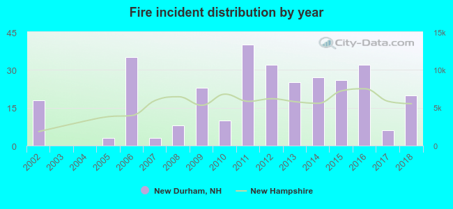 According to the data from the years 2002 - 2018 the average number of fires per year is 18. The highest number of fires - 40 took place in 2011, and the least - 0 in 2003. The data has a growing trend.
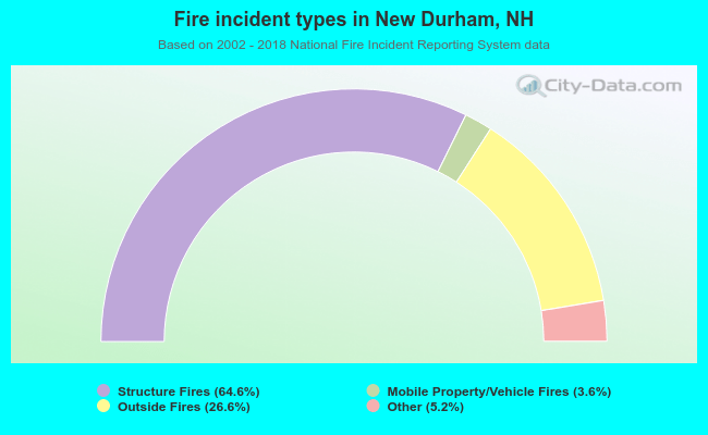 When looking into fire subcategories, the most reports belonged to: Structure Fires (64.6%), and Outside Fires (26.6%).
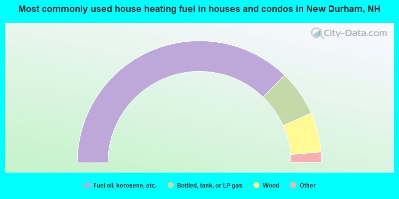
- 74.5%Fuel oil, kerosene, etc.
- 12.2%Bottled, tank, or LP gas
- 10.5%Wood
- 1.6%Electricity
- 1.2%Utility gas
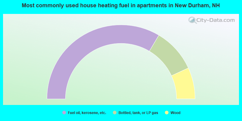
- 67.1%Fuel oil, kerosene, etc.
- 19.2%Bottled, tank, or LP gas
- 13.7%Wood
New Durham compared to New Hampshire state average:
- Unemployed percentage significantly below state average.
- Black race population percentage significantly below state average.
- Hispanic race population percentage significantly below state average.
- Foreign-born population percentage significantly below state average.
- Renting percentage significantly below state average.
- Length of stay since moving in significantly above state average.
- Number of rooms per house significantly below state average.
- House age significantly below state average.

|
|
Total of 23 patent applications in 2008-2024.