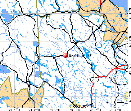
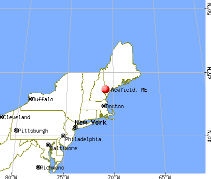
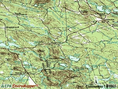
Newfield, Maine
Submit your own pictures of this town and show them to the world
- OSM Map
- General Map
- Google Map
- MSN Map
Population change since 2000: +14.6%
 |
| Males: 773 | |
| Females: 749 |
| Median resident age: | 44.3 years |
| Maine median age: | 43.0 years |
Zip codes: 04095.
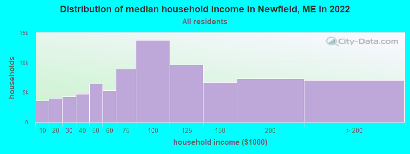
| Newfield: | $72,584 |
| ME: | $69,543 |
Estimated per capita income in 2022: $33,120 (it was $16,280 in 2000)
Newfield town income, earnings, and wages data
Estimated median house or condo value in 2022: $303,763 (it was $95,100 in 2000)
| Newfield: | $303,763 |
| ME: | $290,600 |
Mean prices in 2022: all housing units: $451,552; detached houses: $470,451; townhouses or other attached units: $577,335; in 2-unit structures: $383,179; in 3-to-4-unit structures: $310,696; in 5-or-more-unit structures: $252,113; mobile homes: $105,501
Detailed information about poverty and poor residents in Newfield, ME
Compare current foreclosures near Newfield, ME:
| Photo | Address | Area | Beds / Baths | Price | Details |
|---|---|---|---|---|---|

|
#1
Nason St # B
Sanford, ME 04073
|
1,320 sq. feet
|
1 baths 3 beds |
show details | |

|
#2
White Mountain Hwy
Milton, NH 03851
|
- sq. feet
|
- baths - beds |
show details | |

|
#3
T M Wentworth Rd
Lebanon, ME 04027
|
- sq. feet
|
- baths - beds |
show details | |

|
#4
Ross Corner Rd
Shapleigh, ME 04076
|
- sq. feet
|
- baths - beds |
show details | |

|
#5
Stoneham Rd
Sanbornville, NH 03872
|
- sq. feet
|
- baths - beds |
show details | |

|
#6
Jackson St # B
Sanford, ME 04073
|
- sq. feet
|
- baths - beds |
show details | |

|
#7
Hooper Rd
Shapleigh, ME 04076
|
528 sq. feet
|
- baths - beds |
show details | |

|
#8
Benjamin Dr
Ossipee, NH 03864
|
- sq. feet
|
- baths - beds |
show details | |

|
#9
Main St Apt 404
Sanford, ME 04073
|
- sq. feet
|
- baths - beds |
show details | |

|
#10
Cape Rd
Limington, ME 04049
|
- sq. feet
|
- baths - beds |
show details |
| Photo | Address | Area | Beds / Baths | Price | Details |
|---|---|---|---|---|---|

|
#11
Main St
Springvale, ME 04083
|
- sq. feet
|
- baths - beds |
show details | |

|
#12
Biddeford Rd
Alfred, ME 04002
|
- sq. feet
|
- baths - beds |
show details | |

|
#13
Clark Rd
Wolfeboro, NH 03894
|
- sq. feet
|
- baths - beds |
show details | |

|
#14
Sam Plummer Rd
Milton, NH 03851
|
- sq. feet
|
- baths - beds |
show details | |

|
#15
Harvard St
Sanford, ME 04073
|
- sq. feet
|
- baths - beds |
show details | |

|
#16
Elm St
Limerick, ME 04048
|
- sq. feet
|
- baths - beds |
show details | |

|
#17
Center Rd
Milton, NH 03851
|
- sq. feet
|
- baths - beds |
show details | |

|
#18
Center St
Wolfeboro, NH 03894
|
- sq. feet
|
- baths - beds |
show details | |

|
#19
Harlan Dr
Limington, ME 04049
|
- sq. feet
|
- baths - beds |
show details | |

|
#20
Heath Rd
Sanbornville, NH 03872
|
- sq. feet
|
- baths - beds |
show details |
| Photo | Address | Area | Beds / Baths | Price | Details |
|---|---|---|---|---|---|

|
#21
Sokokis Ave
Limington, ME 04049
|
- sq. feet
|
- baths - beds |
show details | |

|
#22
Wilkinson Swamp Rd
Effingham, NH 03882
|
- sq. feet
|
- baths - beds |
show details | |

|
#23
Tall Pines Ln
Parsonsfield, ME 04047
|
- sq. feet
|
- baths - beds |
show details | |

|
#24
New Dam Rd
North Waterboro, ME 04061
|
- sq. feet
|
- baths - beds |
show details | |

|
#25
Pond Rd
Sanbornville, NH 03872
|
- sq. feet
|
- baths - beds |
show details | |

|
#26
Little River Rd
Lebanon, ME 04027
|
- sq. feet
|
- baths - beds |
show details | |

|
Check over 1 million property listings on Foreclosure.com!
|
browse all offers | |||

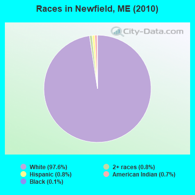
- 1,48597.6%White alone
- 120.8%Two or more races
- 120.8%Hispanic
- 100.7%American Indian alone
- 20.1%Black alone
- 10.07%Asian alone
Races in Newfield detailed stats: ancestries, foreign born residents, place of birth
According to our research of Maine and other state lists, there were 2 registered sex offenders living in Newfield, Maine as of May 18, 2024.
The ratio of all residents to sex offenders in Newfield is 761 to 1.
The ratio of registered sex offenders to all residents in this city is lower than the state average.
 Recent articles from our blog. Our writers, many of them Ph.D. graduates or candidates, create easy-to-read articles on a wide variety of topics.

 | Hi, Mainers! Any info on Newfield? (4 replies) |
| Help Buying a House? (197 replies) |
| Maine Town Passes Ordinance Asserting Local Self-Governance and Stripping Corporate Personhood (28 replies) |
| Where to look to move to in Maine??? (25 replies) |
| Historic settlements, old stone buildings. (15 replies) |
| Really Enjoyable Maine Weekend (15 replies) |
Latest news from Newfield, ME collected exclusively by city-data.com from local newspapers, TV, and radio stations
Ancestries: English (26.7%), French (15.4%), Irish (13.7%), German (8.5%), French Canadian (7.7%), United States (5.4%).
Current Local Time: EST time zone
Incorporated on 02/25/1794
Elevation: 406 feet
Land area: 32.3 square miles.
Population density: 47 people per square mile (very low).
28 residents are foreign born (1.0% Europe, 0.7% North America, 0.3% Latin America).
| This town: | 2.1% |
| Maine: | 2.9% |
| Newfield town: | 0.9% ($902) |
| Maine: | 1.5% ($1,417) |
Nearest city with pop. 50,000+: Portland, ME  (32.2 miles , pop. 64,249).
Nearest city with pop. 200,000+: Boston, MA (91.8 miles , pop. 589,141).
Nearest city with pop. 1,000,000+: Bronx, NY (245.7 miles , pop. 1,332,650).
Nearest cities:
), ), ), ), Latitude: 43.64 N, Longitude: 70.91 W
Area code commonly used in this area: 207

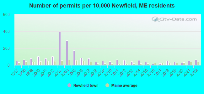
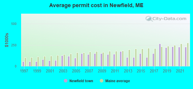
Single-family new house construction building permits:
- 2022: 9 buildings, average cost: $228,200
- 2021: 7 buildings, average cost: $228,200
- 2020: 4 buildings, average cost: $231,500
- 2019: 5 buildings, average cost: $220,000
- 2018: 7 buildings, average cost: $266,000
- 2017: 3 buildings, average cost: $151,000
- 2016: 2 buildings, average cost: $105,000
- 2015: 5 buildings, average cost: $151,000
- 2014: 8 buildings, average cost: $104,200
- 2013: 6 buildings, average cost: $104,200
- 2012: 8 buildings, average cost: $175,000
- 2011: 9 buildings, average cost: $142,600
- 2010: 6 buildings, average cost: $141,700
- 2009: 7 buildings, average cost: $150,000
- 2008: 5 buildings, average cost: $150,000
- 2007: 11 buildings, average cost: $140,500
- 2006: 12 buildings, average cost: $150,000
- 2005: 23 buildings, average cost: $97,800
- 2004: 39 buildings, average cost: $120,800
- 2003: 52 buildings, average cost: $125,000
- 2002: 14 buildings, average cost: $70,700
- 2001: 11 buildings, average cost: $68,200
- 2000: 14 buildings, average cost: $80,000
- 1999: 11 buildings, average cost: $56,500
- 1998: 9 buildings, average cost: $56,600
- 1997: 7 buildings, average cost: $55,300
| Here: | 2.6% |
| Maine: | 3.4% |
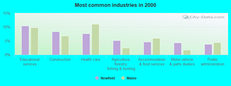
- Educational services (10.4%)
- Construction (8.3%)
- Health care (7.7%)
- Agriculture, forestry, fishing & hunting (5.1%)
- Accommodation & food services (4.6%)
- Motor vehicle & parts dealers (4.3%)
- Public administration (3.8%)
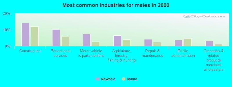
- Construction (14.2%)
- Educational services (10.2%)
- Motor vehicle & parts dealers (7.6%)
- Agriculture, forestry, fishing & hunting (6.5%)
- Repair & maintenance (4.2%)
- Public administration (3.7%)
- Groceries & related products merchant wholesalers (3.1%)

- Health care (15.1%)
- Educational services (10.7%)
- Accommodation & food services (8.1%)
- Finance & insurance (7.0%)
- Professional, scientific, technical services (5.9%)
- Social assistance (5.5%)
- Administrative & support & waste management services (4.8%)
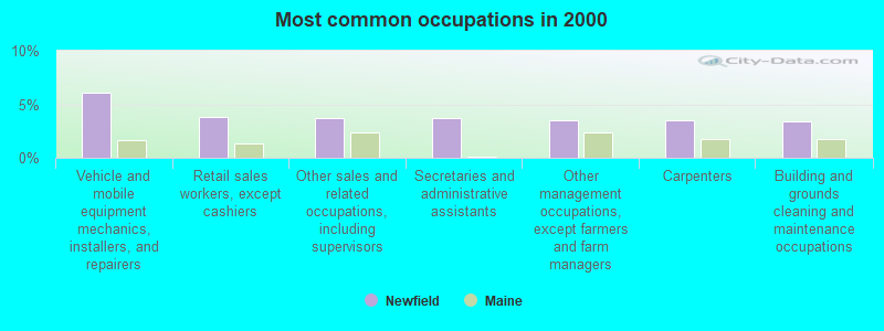
- Vehicle and mobile equipment mechanics, installers, and repairers (6.1%)
- Retail sales workers, except cashiers (3.8%)
- Other sales and related occupations, including supervisors (3.7%)
- Secretaries and administrative assistants (3.7%)
- Other management occupations, except farmers and farm managers (3.5%)
- Carpenters (3.5%)
- Building and grounds cleaning and maintenance occupations (3.4%)

- Vehicle and mobile equipment mechanics, installers, and repairers (10.8%)
- Carpenters (6.2%)
- Electrical equipment mechanics and other installation, maintenance, and repair workers, including supervisors (5.4%)
- Building and grounds cleaning and maintenance occupations (5.4%)
- Fishing, hunting, and forestry occupations (4.2%)
- Retail sales workers, except cashiers (4.0%)
- Driver/sales workers and truck drivers (4.0%)

- Secretaries and administrative assistants (7.7%)
- Nursing, psychiatric, and home health aides (7.4%)
- Other management occupations, except farmers and farm managers (5.5%)
- Other office and administrative support workers, including supervisors (5.5%)
- Other sales and related occupations, including supervisors (4.1%)
- Cooks and food preparation workers (4.1%)
- Art and design workers (3.7%)
Average climate in Newfield, Maine
Based on data reported by over 4,000 weather stations


(lower is better)
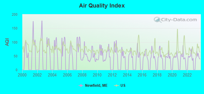
Air Quality Index (AQI) level in 2023 was 48.8. This is significantly better than average.
| City: | 48.8 |
| U.S.: | 72.6 |
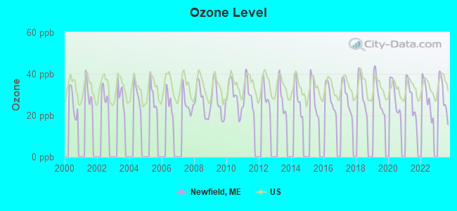
Ozone [ppb] level in 2023 was 29.7. This is about average. Closest monitor was 4.1 miles away from the city center.
| City: | 29.7 |
| U.S.: | 33.3 |
Tornado activity:
Newfield-area historical tornado activity is significantly above Maine state average. It is 68% smaller than the overall U.S. average.
On 7/18/1963, a category F2 (max. wind speeds 113-157 mph) tornado 14.7 miles away from the Newfield town center caused between $5000 and $50,000 in damages.
On 10/10/1966, a category F2 tornado 16.1 miles away from the town center caused between $5000 and $50,000 in damages.
Earthquake activity:
Newfield-area historical earthquake activity is significantly above Maine state average. It is 73% smaller than the overall U.S. average.On 10/16/2012 at 23:12:25, a magnitude 4.7 (4.7 ML, Depth: 10.0 mi, Class: Light, Intensity: IV - V) earthquake occurred 13.2 miles away from Newfield center
On 4/20/2002 at 10:50:47, a magnitude 5.3 (5.3 ML, Depth: 3.0 mi, Class: Moderate, Intensity: VI - VII) earthquake occurred 150.9 miles away from the city center
On 1/19/1982 at 00:14:42, a magnitude 4.7 (4.5 MB, 4.7 MD, 4.5 LG) earthquake occurred 35.9 miles away from Newfield center
On 4/20/2002 at 10:50:47, a magnitude 5.2 (5.2 MB, 4.2 MS, 5.2 MW, 5.0 MW) earthquake occurred 151.2 miles away from the city center
On 10/7/1983 at 10:18:46, a magnitude 5.3 (5.1 MB, 5.3 LG, 5.1 ML) earthquake occurred 172.6 miles away from Newfield center
On 8/21/1996 at 07:54:14, a magnitude 3.8 (3.8 LG, 3.6 LG, Depth: 6.2 mi, Class: Light, Intensity: II - III) earthquake occurred 43.4 miles away from Newfield center
Magnitude types: regional Lg-wave magnitude (LG), body-wave magnitude (MB), duration magnitude (MD), local magnitude (ML), surface-wave magnitude (MS), moment magnitude (MW)
Natural disasters:
The number of natural disasters in York County (31) is a lot greater than the US average (15).Major Disasters (Presidential) Declared: 23
Emergencies Declared: 8
Causes of natural disasters: Floods: 21, Storms: 16, Winter Storms: 6, Snows: 5, Winds: 3, Heavy Rains: 2, Hurricanes: 2, Blizzard: 1, Ice Storm: 1, Mudslide: 1, Snowfall: 1, Snowstorm: 1, Tornado: 1, Tropical Storm: 1 (Note: some incidents may be assigned to more than one category).
Hospitals and medical centers near Newfield:
- MOUNTAIN VIEW NURSING HOME (Nursing Home, about 12 miles away; OSSIPEE, NH)
- HUGGINS HOSPITAL Critical Access Hospitals (about 16 miles away; WOLFEBORO, NH)
- VNA HOSPICE OF S CARROLL CO AND VICINITY (Hospital, about 16 miles away; WOLFEBORO, NH)
- WOLFEBORO BAY CARE AND REHABILITATION CENTER (Nursing Home, about 16 miles away; WOLFEBORO, NH)
Colleges/universities with over 2000 students nearest to Newfield:
- Saint Joseph's College of Maine (about 25 miles; Standish, ME; Full-time enrollment: 2,010)
- University of New England (about 30 miles; Biddeford, ME; FT enrollment: 4,539)
- University of Southern Maine (about 32 miles; Portland, ME; FT enrollment: 6,647)
- Southern Maine Community College (about 35 miles; South Portland, ME; FT enrollment: 4,666)
- University of New Hampshire-Main Campus (about 36 miles; Durham, NH; FT enrollment: 15,243)
- Plymouth State University (about 40 miles; Plymouth, NH; FT enrollment: 4,838)
- NHTI-Concord's Community College (about 43 miles; Concord, NH; FT enrollment: 2,865)
Points of interest:
Notable locations in Newfield: Willowbrook Museum (A), Newfield Fire Department Public Safety Building Rescue Squad (B). Display/hide their locations on the map
Cemeteries: Pleasant Hill Cemetery (1), Reed Cemetery (2). Display/hide their locations on the map
Lakes and reservoirs: Drew Pond (A), Folsom Pond (B), Hidden Lake (C), Mann Pond (D), Mirror Lake (E), Mud Pond (F), Round Pond (G), Smarts Pond (H). Display/hide their locations on the map
Streams, rivers, and creeks: Moulton Brook (A), Chellis Brook (B), Branch Brook (C). Display/hide their locations on the map
Park in Newfield: Newfield Historic District (1). Display/hide its location on the map
Drinking water stations with addresses in Newfield and their reported violations in the past:
WILLOWBROOK MUSEUM VILLAGE (Address: 70 ELM STREET , Population served: 80, Groundwater):Past health violations:Past monitoring violations:
- MCL, Monthly (TCR) - In AUG-2009, Contaminant: Coliform. Follow-up actions: St Public Notif requested (AUG-26-2009), St Formal NOV issued (AUG-26-2009), St Public Notif received (SEP-09-2009), St Compliance achieved (SEP-07-2011)
- 2 routine major monitoring violations
| This town: | 2.4 people |
| Maine: | 2.3 people |
| This town: | 72.0% |
| Whole state: | 62.9% |
| This town: | 8.3% |
| Whole state: | 9.4% |
Likely homosexual households (counted as self-reported same-sex unmarried-partner households)
- Lesbian couples: 0.3% of all households
- Gay men: 0.5% of all households
| This town: | 10.4% |
| Whole state: | 10.9% |
| This town: | 4.0% |
| Whole state: | 4.1% |
For population 15 years and over in Newfield:
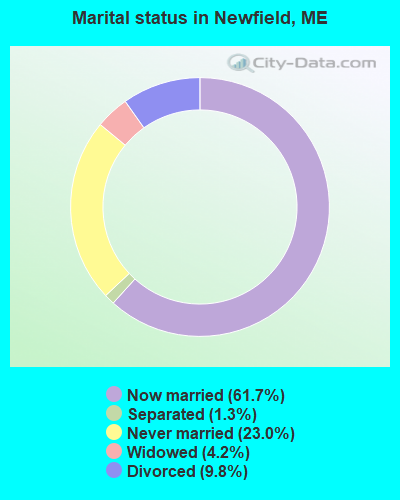
- Never married: 23.0%
- Now married: 61.7%
- Separated: 1.3%
- Widowed: 4.2%
- Divorced: 9.8%
For population 25 years and over in Newfield:
- High school or higher: 84.1%
- Bachelor's degree or higher: 15.5%
- Graduate or professional degree: 5.2%
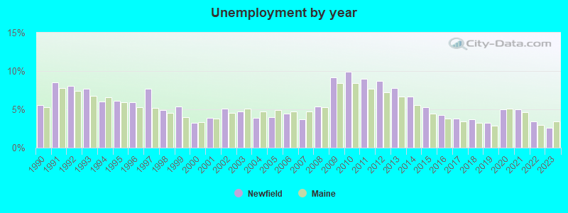
- Unemployed: 4.4%
- Mean travel time to work (commute): 37.8 minutes

| Here: | 9.6 |
| Maine average: | 11.2 |


Graphs represent county-level data. Detailed 2008 Election Results
Religion statistics for Newfield, ME (based on York County data)
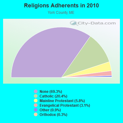

| Religion | Adherents | Congregations |
|---|---|---|
| Catholic | 40,283 | 16 |
| Mainline Protestant | 11,480 | 64 |
| Evangelical Protestant | 6,086 | 51 |
| Other | 1,847 | 18 |
| Orthodox | 625 | 3 |
| Black Protestant | 119 | 1 |
| None | 136,691 | - |
Food Environment Statistics:
| York County: | 2.24 / 10,000 pop. |
| State: | 2.80 / 10,000 pop. |
| York County: | 0.05 / 10,000 pop. |
| Maine: | 0.14 / 10,000 pop. |
| This county: | 2.09 / 10,000 pop. |
| Maine: | 2.20 / 10,000 pop. |
| This county: | 4.23 / 10,000 pop. |
| Maine: | 5.75 / 10,000 pop. |
| This county: | 12.53 / 10,000 pop. |
| State: | 11.02 / 10,000 pop. |
| This county: | 7.7% |
| Maine: | 8.2% |
| Here: | 24.0% |
| Maine: | 25.0% |
Strongest AM radio stations in Newfield:
- WMTW (870 AM; 10 kW; GORHAM, ME; Owner: RADIO PARTNERS OF MAINE, L.P.)
- WGIN (930 AM; 10 kW; ROCHESTER, NH; Owner: CAPSTAR TX LIMITED PARTNERSHIP)
- WASR (1420 AM; 5 kW; WOLFEBORO, NH; Owner: RADIO WOLFEBORO, INC.)
- WRKO (680 AM; 50 kW; BOSTON, MA; Owner: ENTERCOM BOSTON LICENSE, LLC)
- WGAN (560 AM; 5 kW; PORTLAND, ME; Owner: SAGA COMMUNICATIONS OF NEW ENGLAND, LLC)
- WEEI (850 AM; 50 kW; BOSTON, MA; Owner: ENTERCOM BOSTON LICENSE, LLC)
- WZAN (970 AM; 5 kW; PORTLAND, ME; Owner: SAGA COMMUNICATIONS OF NEW ENGLAND, LLC)
- WBZ (1030 AM; 50 kW; BOSTON, MA; Owner: INFINITY BROADCASTING OPERATIONS, INC.)
- WJAE (1440 AM; 5 kW; WESTBROOK, ME; Owner: ALTANTIC COAST RADIO, LLC)
- WCRN (830 AM; 50 kW; WORCESTER, MA; Owner: CARTER BROADCASTING CORPORATION)
- WLOB (1310 AM; 5 kW; PORTLAND, ME; Owner: ATLANTIC COAST RADIO, LLC)
- WKOX (1200 AM; 50 kW; FRAMINGHAM, MA; Owner: CAPSTAR TX LIMITED PARTNERSHIP)
- WWZN (1510 AM; 50 kW; BOSTON, MA; Owner: ROSE CITY RADIO CORPORATION)
Strongest FM radio stations in Newfield:
- WMEA (90.1 FM; PORTLAND, ME; Owner: MAINE PUBLIC BROADCASTING CORPORATION)
- WSCY (106.9 FM; MOULTONBOROUGH, NH; Owner: NORTHEAST COMMUNICATIONS CORPORATION)
- WPKQ (103.7 FM; NORTH CONWAY, NH; Owner: CITADEL BROADCASTING COMPANY)
- WHOM (94.9 FM; MT. WASHINGTON, NH; Owner: CITADEL BROADCASTING COMPANY)
- WBLM (102.9 FM; PORTLAND, ME; Owner: CITADEL BROADCASTING COMPANY)
- WVFM (105.7 FM; CAMPTON, NH; Owner: DEVON BROADCASTING COMPANY, INC.)
- WLKZ (104.9 FM; WOLFEBORO, NH; Owner: TELE-MEDIA COMPANY OF NEW HAMPSHIRE, L.L.C.)
- WPHX-FM (92.1 FM; SANFORD, ME; Owner: FNX BROADCASTING LLC)
- WSEW (88.5 FM; SANFORD, ME; Owner: WORD RADIO EDUCATIONAL FOUNDATION)
- WMEX (106.5 FM; FARMINGTON, NH; Owner: WIMMEX, LLC)
- WJBQ (97.9 FM; PORTLAND, ME; Owner: CITADEL BROADCASTING COMPANY)
- WNHI (93.3 FM; BELMONT, NH; Owner: CONCORD BROADCASTING, L.L.C.)
- WPNH-FM (100.1 FM; PLYMOUTH, NH; Owner: NORTHEAST COMMUNICATIONS CORPORATION)
- WTHT (107.5 FM; LEWISTON, ME; Owner: RADIO PARTNERS OF MAINE, L.P.)
- WUBB (95.3 FM; YORK CENTER, ME; Owner: CAPSTAR TX LIMITED PARTNERSHIP)
- WPOR (101.9 FM; PORTLAND, ME; Owner: SAGA COMMUNICATIONS OF NEW ENGLAND, LLC)
- WVMJ (104.5 FM; CONWAY, NH; Owner: MT. WASHINGTON RADIO & GRAMOPHONE, L.L.C.)
- WMWV (93.5 FM; CONWAY, NH; Owner: MT. WASHINGTON RADIO & GRAMOPHONE, L.L.C.)
- WCYY (94.3 FM; BIDDEFORD, ME; Owner: CITADEL BROADCASTING COMPANY)
- WMTW-FM (106.7 FM; NORTH WINDHAM, ME; Owner: RADIO PARTNERS OF MAINE, L.P.)
TV broadcast stations around Newfield:
- WMTW-TV (Channel 8; POLAND SPRING, ME; Owner: WMTW BROADCAST GROUP, LLC)
- WMEA-TV (Channel 26; BIDDEFORD, ME; Owner: MAINE PUBLIC BROADCASTING CORP.)
- WCSH (Channel 6; PORTLAND, ME; Owner: PACIFIC AND SOUTHERN COMPANY, INC.)
- WGME-TV (Channel 13; PORTLAND, ME; Owner: WGME LICENSEE, LLC)
- WPXT (Channel 51; PORTLAND, ME; Owner: HMW, INC.)
- WPME (Channel 35; LEWISTON, ME; Owner: KB PRIME MEDIA LLC)
Newfield fatal accident list:
Jun 28, 2006 12:14 AM, Sr-11, Lat: 43.686300, Lon: -70.795620, Vehicles: 1, Persons: 1, Fatalities: 1, Drunk persons involved: 1
Aug 20, 2002 12:23 AM, Sr-11, Vehicles: 1, Persons: 1, Fatalities: 1
Oct 12, 1994 02:30 PM, 11, Vehicles: 2, Persons: 2, Fatalities: 1
Jul 6, 1992 02:30 AM, Maplewood, Vehicles: 1, Persons: 1, Fatalities: 1, Drunk persons involved: 1
May 99, 1988 87:99 PM, 21272140, Vehicles: 1, Persons: 1, Fatalities: 1, Drunk persons involved: 1
- National Bridge Inventory (NBI) Statistics
- 1Number of bridges
- 7ft / 2.3mTotal length
- 1,060Total average daily traffic
- 53Total average daily truck traffic
- 1,590Total future (year 2036) average daily traffic
FCC Registered Antenna Towers:
3- Michael J Umano, Off Wakefield Road (Lat: 43.641167 Lon: -70.916028), Type: 60.9, Overall height: 59.4 m, Registrant: Kevin.Delaney@induscom.Com, Phone: (781) 319-1011
- Michael J Umano, Off Gile Road (Lat: 43.607222 Lon: -70.890694), Type: 60.9, Overall height: 59.4 m, Registrant: Kevin.Delaney@induscom.Com, Phone: (781) 319-1011
- Michael J Umano, Off Wakefield Road (Lat: 43.641167 Lon: -70.916028), Type: 60.9, Structure height: 23031 m, Overall height: 59.4 m, Registrant: Kevin.Delaney@induscom.Com, Phone: (781) 319-1011
FCC Registered Amateur Radio Licenses:
5- Call Sign: KA1WAO, Licensee ID: L00171378, Grant Date: 08/24/2000, Expiration Date: 11/20/2010, Cancellation Date: 11/21/2012, Registrant: Charles F Hicks, Newfield, ME 04056
- Call Sign: KB1MRF, Licensee ID: L01072525, Grant Date: 10/12/2005, Expiration Date: 10/12/2015, Cancellation Date: 01/10/2006, Certifier: Laura L Harvey, Registrant: Laura L Harvey, 31 Coolidge St, W Newfield, ME 04095
- Call Sign: WB1RDS, Previous Call Sign: KB1MRF, Licensee ID: L01072525, Grant Date: 01/10/2006, Expiration Date: 01/10/2016, Cancellation Date: 01/11/2018, Certifier: Laura L Harvey, Registrant: Laura L Harvey, 31 Coolidge St, W Newfield, ME 04095
- Call Sign: KB1NZJ, Licensee ID: L01199544, Grant Date: 10/05/2006, Expiration Date: 10/05/2016, Cancellation Date: 10/28/2006, Certifier: Maureen M Stone, Registrant: Maureen M Stone, 281 Garland Rd, W Newfield, ME 04095
- Call Sign: K1PHF, Previous Call Sign: KB1NZJ, Licensee ID: L01199544, Grant Date: 11/01/2016, Expiration Date: 11/01/2026, Certifier: Maureen M Stone, Registrant: Maureen M Stone, 281 Garland Rd, W Newfield, ME 04095
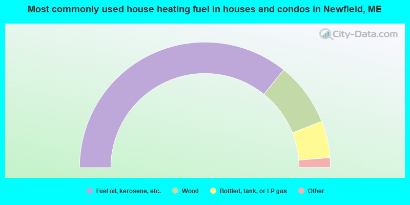
- 71.5%Fuel oil, kerosene, etc.
- 16.4%Wood
- 9.5%Bottled, tank, or LP gas
- 1.2%Solar energy
- 0.9%Electricity
- 0.5%Utility gas
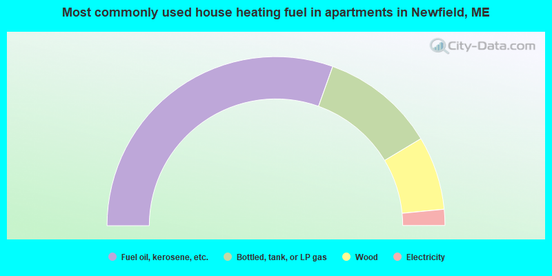
- 60.9%Fuel oil, kerosene, etc.
- 21.9%Bottled, tank, or LP gas
- 14.1%Wood
- 3.1%Electricity
Newfield compared to Maine state average:
- Unemployed percentage significantly below state average.
- Black race population percentage significantly below state average.
- Hispanic race population percentage below state average.
- Foreign-born population percentage below state average.
- Renting percentage significantly below state average.
- Length of stay since moving in significantly above state average.
- Number of rooms per house significantly below state average.
- House age significantly below state average.
- Number of college students below state average.
- Percentage of population with a bachelor's degree or higher below state average.

|
Total of 6 patent applications in 2008-2024.