Northfield, New Hampshire
Submit your own pictures of this town and show them to the world
- OSM Map
- General Map
- Google Map
- MSN Map
Population change since 2000: +6.2%
 |
| Males: 2,387 | |
| Females: 2,442 |
| Median resident age: | 39.2 years |
| New Hampshire median age: | 43.9 years |
Zip codes: 03276.
| Northfield: | $77,379 |
| NH: | $89,992 |
Estimated per capita income in 2022: $36,989 (it was $18,466 in 2000)
Northfield town income, earnings, and wages data
Estimated median house or condo value in 2022: $281,964 (it was $90,100 in 2000)
| Northfield: | $281,964 |
| NH: | $384,700 |
Mean prices in 2022: all housing units: $378,901; detached houses: $416,256; townhouses or other attached units: $317,750; in 2-unit structures: $298,869; in 3-to-4-unit structures: $371,619; in 5-or-more-unit structures: $216,601; mobile homes: $110,180; occupied boats, rvs, vans, etc.: $74,347
Detailed information about poverty and poor residents in Northfield, NH
Compare current foreclosures near Northfield, NH:
| Photo | Address | Area | Beds / Baths | Price | Details |
|---|---|---|---|---|---|

|
#1
N State St
Concord, NH 03301
|
1,920 sq. feet
|
1 baths 3 beds |
show details | |

|
#2
Flaghole Rd
Franklin, NH 03235
|
1,352 sq. feet
|
2 baths 3 beds |
show details | |

|
#3
Cheshire Cir
Gilford, NH 03249
|
3,492 sq. feet
|
2 baths 3 beds |
show details | |

|
#4
Union Rd
Belmont, NH 03220
|
1,104 sq. feet
|
1 baths 2 beds |
show details | |

|
#5
Ward Hill Rd
Franklin, NH 03235
|
1,700 sq. feet
|
2 baths 3 beds |
show details | |

|
#6
Fairview Dr
Pittsfield, NH 03263
|
2,070 sq. feet
|
2 baths 3 beds |
show details | |

|
#7
Brook Rd # 2
Sanbornton, NH 03269
|
2,128 sq. feet
|
2 baths 4 beds |
show details | |

|
#8
Duck Pond Ln
Warner, NH 03278
|
1,120 sq. feet
|
1 baths 3 beds |
show details | |

|
#9
Eastman Hill Rd
Sanbornton, NH 03269
|
4,836 sq. feet
|
2 baths 4 beds |
show details | |

|
#10
Taylor Rd
Sanbornton, NH 03269
|
2,160 sq. feet
|
2 baths 4 beds |
show details |
| Photo | Address | Area | Beds / Baths | Price | Details |
|---|---|---|---|---|---|

|
#11
Plymouth St
Meredith, NH 03253
|
2,232 sq. feet
|
2 baths 4 beds |
show details | |

|
#12
Strafford St
Laconia, NH 03246
|
1,820 sq. feet
|
2 baths 4 beds |
show details | |

|
#13
Adams St
Laconia, NH 03246
|
1,956 sq. feet
|
1 baths 3 beds |
show details | |

|
#14
Province St
Laconia, NH 03246
|
818 sq. feet
|
1 baths 2 beds |
show details | |

|
#15
Richmond Dr
Concord, NH 03303
|
1,776 sq. feet
|
2 baths 3 beds |
show details | |

|
#16
Abbott Rd
Concord, NH 03303
|
1,386 sq. feet
|
1 baths 2 beds |
show details | |

|
#17
Mechanic St
Laconia, NH 03246
|
2,537 sq. feet
|
2 baths 4 beds |
show details | |

|
#18
Drake Rd
Sanbornton, NH 03269
|
2,376 sq. feet
|
2 baths 3 beds |
show details | |

|
#19
Pine Stump Rd
Sanbornton, NH 03269
|
1,976 sq. feet
|
1 baths 4 beds |
show details | |

|
#20
Shaw Hill Rd
Sanbornton, NH 03269
|
1,976 sq. feet
|
1 baths 3 beds |
show details |
| Photo | Address | Area | Beds / Baths | Price | Details |
|---|---|---|---|---|---|

|
#21
S Fruit St
Concord, NH 03301
|
1,768 sq. feet
|
2 baths 4 beds |
show details | |

|
#22
Fairview Road Aka 42 Fairview Drive
Pittsfield, NH Array
|
2,078 sq. feet
|
2 baths 3 beds |
show details | |

|
#23
N State St
Concord, NH 03301
|
6,861 sq. feet
|
7 baths 5 beds |
show details | |

|
#24
Union Ave
Laconia, NH 03246
|
6,055 sq. feet
|
2 baths - beds |
show details | |

|
#25
Goboro Rd # 2
Epsom, NH 03234
|
- sq. feet
|
- baths - beds |
show details | |

|
#26
Mulberry St Unit 3
Concord, NH 03301
|
- sq. feet
|
- baths - beds |
show details | |

|
#27
Eldridge St
Concord, NH 03301
|
- sq. feet
|
- baths - beds |
show details | |

|
#28
S Main St
Concord, NH 03301
|
- sq. feet
|
- baths - beds |
show details | |

|
#29
Alice Dr Apt 108
Concord, NH 03303
|
- sq. feet
|
- baths - beds |
show details | |

|
#30
Perley St
Concord, NH 03301
|
- sq. feet
|
- baths - beds |
show details |
| Photo | Address | Area | Beds / Baths | Price | Details |
|---|---|---|---|---|---|

|
#31
Cabernet Dr Unit 2
Concord, NH 03303
|
- sq. feet
|
- baths - beds |
show details | |

|
#32
Endicott St N Unit 420
Laconia, NH 03246
|
- sq. feet
|
- baths - beds |
show details | |

|
#33
1/2 Walker St
Concord, NH 03301
|
- sq. feet
|
- baths - beds |
show details | |

|
#34
Annis Dr Unit 10
Gilford, NH 03249
|
- sq. feet
|
- baths - beds |
show details | |

|
#35
S Main St Apt 3
Concord, NH 03301
|
- sq. feet
|
- baths - beds |
show details | |

|
#36
Lawrence St
Concord, NH 03301
|
- sq. feet
|
- baths - beds |
show details | |

|
#37
Chichester Rd
Loudon, NH 03307
|
- sq. feet
|
- baths - beds |
show details | |

|
#38
Canton Cir
Concord, NH 03301
|
- sq. feet
|
- baths - beds |
show details | |

|
#39
N State St, Number 57835
Concord, NH 03301
|
- sq. feet
|
- baths - beds |
show details | |

|
#40
N State St Apt 7
Concord, NH 03301
|
- sq. feet
|
- baths - beds |
show details |
| Photo | Address | Area | Beds / Baths | Price | Details |
|---|---|---|---|---|---|

|
#41
Rumford St # 3
Concord, NH 03301
|
- sq. feet
|
- baths - beds |
show details | |

|
#42
N Main St Apt 33
Laconia, NH 03246
|
- sq. feet
|
- baths - beds |
show details | |

|
#43
Bay Hill Rd # 1
Tilton, NH 03276
|
- sq. feet
|
- baths - beds |
show details | |

|
#44
Estates Cir Apt 24
Laconia, NH 03246
|
- sq. feet
|
- baths - beds |
show details | |

|
#45
Durkee St # B
Laconia, NH 03246
|
- sq. feet
|
- baths - beds |
show details | |

|
#46
Summer St Apt 19
Tilton, NH 03276
|
- sq. feet
|
- baths - beds |
show details | |

|
#47
Prospect St Apt 2
Tilton, NH 03276
|
- sq. feet
|
- baths - beds |
show details | |

|
#48
Scribner Rd # 78
Tilton, NH 03276
|
- sq. feet
|
- baths - beds |
show details | |

|
#49
Wethersfield Dr
Tilton, NH 03276
|
- sq. feet
|
- baths - beds |
show details | |

|
Check over 1 million property listings on Foreclosure.com!
|
browse all offers | |||

- 4,61595.6%White alone
- 701.4%Hispanic
- 521.1%Two or more races
- 380.8%Asian alone
- 350.7%Black alone
- 150.3%American Indian alone
- 40.08%Other race alone
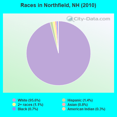
Races in Northfield detailed stats: ancestries, foreign born residents, place of birth
According to our research of New Hampshire and other state lists, there were 9 registered sex offenders living in Northfield, New Hampshire as of May 17, 2024.
The ratio of all residents to sex offenders in Northfield is 537 to 1.
The ratio of registered sex offenders to all residents in this city is near the state average.
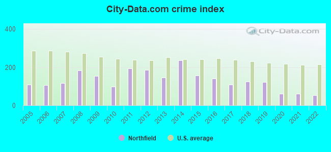
Type |
2009 |
2010 |
2011 |
2012 |
2013 |
2014 |
2015 |
2016 |
2017 |
2018 |
2019 |
2020 |
2021 |
2022 |
|---|---|---|---|---|---|---|---|---|---|---|---|---|---|---|
| Murders (per 100,000) | 0 (0.0) | 0 (0.0) | 0 (0.0) | 0 (0.0) | 0 (0.0) | 0 (0.0) | 0 (0.0) | 0 (0.0) | 0 (0.0) | 0 (0.0) | 0 (0.0) | 0 (0.0) | 0 (0.0) | 0 (0.0) |
| Rapes (per 100,000) | 2 (38.6) | 0 (0.0) | 3 (62.0) | 2 (41.3) | 0 (0.0) | 1 (20.8) | 2 (41.7) | 3 (62.4) | 2 (41.5) | 2 (41.1) | 2 (40.5) | 0 (0.0) | 0 (0.0) | 0 (0.0) |
| Robberies (per 100,000) | 0 (0.0) | 0 (0.0) | 2 (41.4) | 1 (20.7) | 0 (0.0) | 1 (20.8) | 1 (20.8) | 1 (20.8) | 1 (20.8) | 1 (20.6) | 1 (20.2) | 0 (0.0) | 0 (0.0) | 0 (0.0) |
| Assaults (per 100,000) | 3 (57.8) | 5 (103.5) | 5 (103.4) | 6 (123.9) | 8 (165.7) | 15 (311.9) | 6 (125.1) | 6 (124.9) | 5 (103.9) | 9 (185.0) | 4 (81.0) | 1 (20.2) | 1 (20.0) | 2 (40.0) |
| Burglaries (per 100,000) | 33 (636.2) | 16 (331.3) | 27 (558.4) | 22 (454.4) | 18 (372.7) | 31 (644.5) | 19 (396.1) | 7 (145.7) | 1 (20.8) | 10 (205.6) | 15 (303.6) | 3 (60.5) | 6 (120.1) | 4 (80.0) |
| Thefts (per 100,000) | 81 (1,562) | 59 (1,222) | 84 (1,737) | 92 (1,900) | 99 (2,050) | 118 (2,453) | 71 (1,480) | 53 (1,103) | 38 (789.4) | 35 (719.6) | 46 (931.2) | 51 (1,029) | 41 (820.8) | 43 (860.3) |
| Auto thefts (per 100,000) | 3 (57.8) | 3 (62.1) | 2 (41.4) | 9 (185.9) | 3 (62.1) | 5 (104.0) | 3 (62.5) | 3 (62.4) | 10 (207.7) | 3 (61.7) | 6 (121.5) | 8 (161.4) | 10 (200.2) | 4 (80.0) |
| Arson (per 100,000) | 1 (19.3) | 0 (0.0) | 1 (20.7) | 2 (41.3) | 0 (0.0) | 1 (20.8) | 0 (0.0) | 0 (0.0) | 1 (20.8) | 0 (0.0) | 0 (0.0) | 1 (20.2) | 0 (0.0) | 0 (0.0) |
| City-Data.com crime index | 154.0 | 97.7 | 194.6 | 186.7 | 146.2 | 236.8 | 156.6 | 140.5 | 109.9 | 124.2 | 122.9 | 62.3 | 61.3 | 54.4 |
The City-Data.com crime index weighs serious crimes and violent crimes more heavily. Higher means more crime, U.S. average is 246.1. It adjusts for the number of visitors and daily workers commuting into cities.
Crime rate in Northfield detailed stats: murders, rapes, robberies, assaults, burglaries, thefts, arson
Full-time law enforcement employees in 2021, including police officers: 9 (9 officers - 8 male; 1 female).
| Officers per 1,000 residents here: | 1.80 |
| New Hampshire average: | 2.14 |
 Recent articles from our blog. Our writers, many of them Ph.D. graduates or candidates, create easy-to-read articles on a wide variety of topics.

 | Nicest towns in Southern NH? (19 replies) |
| Tilton/Northfield (3 replies) |
| Buying Home in NH from SC. Renting out temp. until move? NEED ADVICE! (36 replies) |
| Moving to Southern NH/ Pipeline concerns (26 replies) |
| Mystery on little jaunt yesterday (10 replies) |
| Pipeline and Power line questions (11 replies) |
Latest news from Northfield, NH collected exclusively by city-data.com from local newspapers, TV, and radio stations
Ancestries: Irish (17.2%), French (17.2%), English (17.0%), United States (9.6%), French Canadian (9.5%), German (6.3%).
Current Local Time: EST time zone
Incorporated in 1780
Elevation: 450 feet
Land area: 28.8 square miles.
Population density: 168 people per square mile (very low).
85 residents are foreign born
| This town: | 1.9% |
| New Hampshire: | 4.4% |
| Northfield town: | 2.5% ($2,272) |
| New Hampshire: | 2.3% ($2,946) |
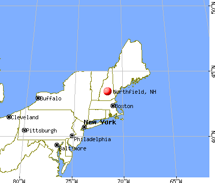
Nearest city with pop. 50,000+: Manchester, NH  (30.8 miles , pop. 107,006).
Nearest city with pop. 200,000+: Boston, MA (80.1 miles , pop. 589,141).
Nearest city with pop. 1,000,000+: Bronx, NY (213.4 miles , pop. 1,332,650).
Nearest cities:
), ), )Latitude: 43.42 N, Longitude: 71.58 W
Area code commonly used in this area: 603

Single-family new house construction building permits:
- 2022: 16 buildings, average cost: $279,200
- 2021: 14 buildings, average cost: $351,400
- 2020: 14 buildings, average cost: $248,200
- 2019: 10 buildings, average cost: $334,000
- 2018: 9 buildings, average cost: $299,100
- 2017: 12 buildings, average cost: $227,000
- 2016: 11 buildings, average cost: $141,500
- 2015: 3 buildings, average cost: $218,300
- 2014: 4 buildings, average cost: $207,800
- 2013: 1 building, cost: $165,000
- 2011: 2 buildings, average cost: $127,000
- 2010: 4 buildings, average cost: $187,500
- 2009: 2 buildings, average cost: $187,500
- 2008: 2 buildings, average cost: $225,000
- 2007: 6 buildings, average cost: $154,300
- 2006: 8 buildings, average cost: $201,300
- 2005: 98 buildings, average cost: $194,200
- 2004: 30 buildings, average cost: $193,800
- 2003: 38 buildings, average cost: $198,800
- 2002: 37 buildings, average cost: $123,600
- 2001: 35 buildings, average cost: $122,300
- 2000: 28 buildings, average cost: $132,200
- 1999: 15 buildings, average cost: $110,900
- 1998: 8 buildings, average cost: $90,800
- 1997: 8 buildings, average cost: $82,300
| Here: | 2.5% |
| New Hampshire: | 2.5% |
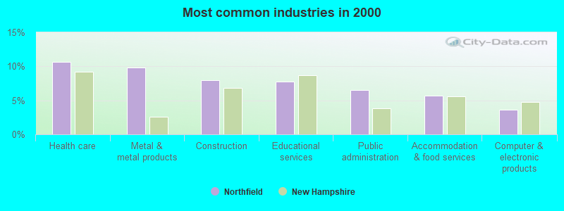
- Health care (10.7%)
- Metal & metal products (9.8%)
- Construction (8.0%)
- Educational services (7.7%)
- Public administration (6.5%)
- Accommodation & food services (5.7%)
- Computer & electronic products (3.6%)
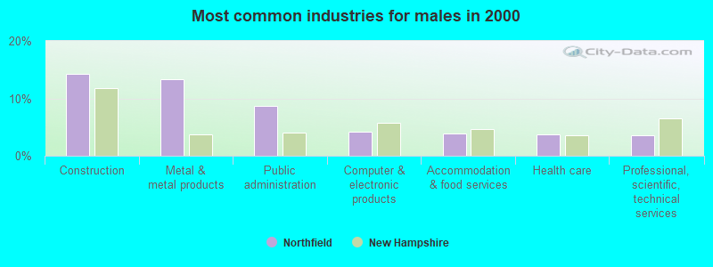
- Construction (14.3%)
- Metal & metal products (13.3%)
- Public administration (8.7%)
- Computer & electronic products (4.2%)
- Accommodation & food services (3.9%)
- Health care (3.8%)
- Professional, scientific, technical services (3.5%)
- Health care (18.1%)
- Educational services (14.0%)
- Accommodation & food services (7.6%)
- Social assistance (6.8%)
- Metal & metal products (6.0%)
- Department & other general merchandise stores (4.2%)
- Public administration (4.1%)
- Other production occupations, including supervisors (6.2%)
- Metal workers and plastic workers (4.3%)
- Assemblers and fabricators (3.9%)
- Other management occupations, except farmers and farm managers (3.7%)
- Electrical equipment mechanics and other installation, maintenance, and repair workers, including supervisors (3.7%)
- Other sales and related occupations, including supervisors (3.5%)
- Vehicle and mobile equipment mechanics, installers, and repairers (3.1%)
- Other production occupations, including supervisors (9.4%)
- Electrical equipment mechanics and other installation, maintenance, and repair workers, including supervisors (6.6%)
- Metal workers and plastic workers (6.2%)
- Vehicle and mobile equipment mechanics, installers, and repairers (5.9%)
- Driver/sales workers and truck drivers (4.9%)
- Construction traders workers except carpenters, electricians, painters, plumbers, and construction laborers (4.8%)
- Drafters, engineering, and mapping technicians (4.0%)
- Secretaries and administrative assistants (5.7%)
- Assemblers and fabricators (5.6%)
- Retail sales workers, except cashiers (4.7%)
- Preschool, kindergarten, elementary, and middle school teachers (4.1%)
- Health technologists and technicians (4.1%)
- Other management occupations, except farmers and farm managers (4.0%)
- Information and record clerks, except customer service representatives (4.0%)
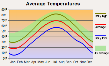
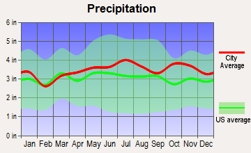
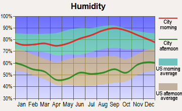
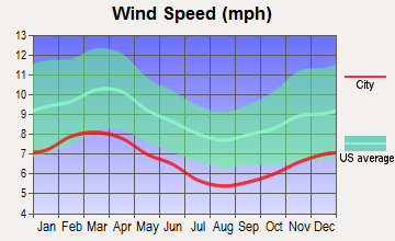
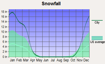
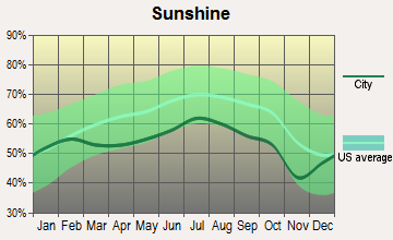
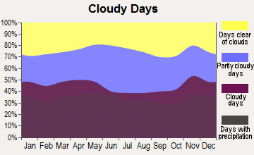
Average climate in Northfield, New Hampshire
Based on data reported by over 4,000 weather stations
(lower is better)
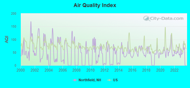
Air Quality Index (AQI) level in 2022 was 51.1. This is significantly better than average.
| City: | 51.1 |
| U.S.: | 72.6 |
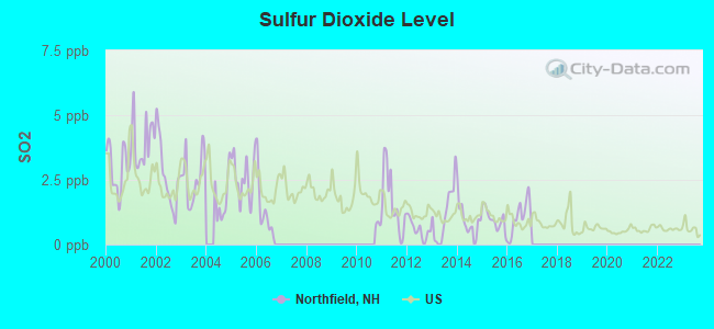
Sulfur Dioxide (SO2) [ppb] level in 2016 was 1.05. This is significantly better than average. Closest monitor was 14.5 miles away from the city center.
| City: | 1.05 |
| U.S.: | 1.51 |
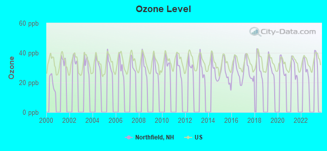
Ozone [ppb] level in 2022 was 29.6. This is about average. Closest monitor was 10.8 miles away from the city center.
| City: | 29.6 |
| U.S.: | 33.3 |
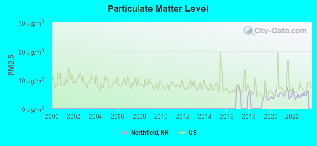
Particulate Matter (PM2.5) [µg/m3] level in 2022 was 4.52. This is significantly better than average. Closest monitor was 8.6 miles away from the city center.
| City: | 4.52 |
| U.S.: | 8.11 |
Tornado activity:
Northfield-area historical tornado activity is near New Hampshire state average. It is 54% smaller than the overall U.S. average.
On 7/3/1972, a category F2 (max. wind speeds 113-157 mph) tornado 7.6 miles away from the Northfield town center injured 7 people and caused between $5000 and $50,000 in damages.
On 7/6/1999, a category F2 tornado 15.2 miles away from the town center .
Earthquake activity:
Northfield-area historical earthquake activity is significantly above New Hampshire state average. It is 71% smaller than the overall U.S. average.On 4/20/2002 at 10:50:47, a magnitude 5.3 (5.3 ML, Depth: 3.0 mi, Class: Moderate, Intensity: VI - VII) earthquake occurred 129.6 miles away from the city center
On 1/19/1982 at 00:14:42, a magnitude 4.7 (4.5 MB, 4.7 MD, 4.5 LG, Class: Light, Intensity: IV - V) earthquake occurred 5.5 miles away from the city center
On 10/7/1983 at 10:18:46, a magnitude 5.3 (5.1 MB, 5.3 LG, 5.1 ML) earthquake occurred 142.9 miles away from the city center
On 4/20/2002 at 10:50:47, a magnitude 5.2 (5.2 MB, 4.2 MS, 5.2 MW, 5.0 MW) earthquake occurred 129.4 miles away from the city center
On 10/16/2012 at 23:12:25, a magnitude 4.7 (4.7 ML, Depth: 10.0 mi) earthquake occurred 47.9 miles away from Northfield center
On 8/21/1996 at 07:54:14, a magnitude 3.8 (3.8 LG, 3.6 LG, Depth: 6.2 mi, Class: Light, Intensity: II - III) earthquake occurred 53.9 miles away from the city center
Magnitude types: regional Lg-wave magnitude (LG), body-wave magnitude (MB), duration magnitude (MD), local magnitude (ML), surface-wave magnitude (MS), moment magnitude (MW)
Natural disasters:
The number of natural disasters in Merrimack County (27) is a lot greater than the US average (15).Major Disasters (Presidential) Declared: 17
Emergencies Declared: 9
Causes of natural disasters: Storms: 13, Floods: 12, Winter Storms: 4, Snowstorms: 3, Hurricanes: 2, Snows: 2, Blizzard: 1, Ice Storm: 1, Snowfall: 1, Tornado: 1, Tropical Storm: 1, Wind: 1, Other: 1 (Note: some incidents may be assigned to more than one category).
Hospitals and medical centers near Northfield:
- MOUNTAIN RIDGE CENTER, GENESIS HEALTHCARE (Nursing Home, about 3 miles away; FRANKLIN, NH)
- VNA OF FRANKLIN (Home Health Center, about 4 miles away; FRANKLIN, NH)
- FRANKLIN REGIONAL HOSPITAL Critical Access Hospitals (about 4 miles away; FRANKLIN, NH)
- MERRILL MANOR ANNEX (Nursing Home, about 5 miles away; FRANKLIN, NH)
- MERRILL MANOR NURSING HOME (Nursing Home, about 5 miles away; FRANKLIN, NH)
- MERRIMACK COUNTY NURSING HOME (Nursing Home, about 6 miles away; BOSCAWEN, NH)
- SAINT FRANCIS REHABILITATION AND NURSING CENTER (Nursing Home, about 9 miles away; LACONIA, NH)
Colleges/universities with over 2000 students nearest to Northfield:
- NHTI-Concord's Community College (about 14 miles; Concord, NH; Full-time enrollment: 2,865)
- Plymouth State University (about 24 miles; Plymouth, NH; FT enrollment: 4,838)
- Southern New Hampshire University (about 28 miles; Manchester, NH; FT enrollment: 16,552)
- Saint Anselm College (about 31 miles; Manchester, NH; FT enrollment: 2,059)
- Mount Washington College (about 32 miles; Manchester, NH; FT enrollment: 2,187)
- University of New Hampshire-Main Campus (about 39 miles; Durham, NH; FT enrollment: 15,243)
- Dartmouth College (about 41 miles; Hanover, NH; FT enrollment: 6,030)
Private high school in Northfield:
- SPAULDING YOUTH CENTER (Students: 63, Location: 130 SHEDD RD, Grades: 1-12)
Public elementary/middle schools in Northfield:
- UNION SANBORN SCHOOL (Students: 284, Location: 5 ELM ST., Grades: PK-2)
- SOUTHWICK SCHOOL (Students: 252, Location: 50 ZION HILL RD., Grades: 3-5)
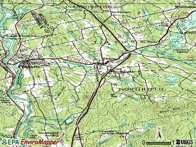
Points of interest:
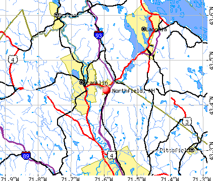
Notable locations in Northfield: Winnisquam Mill (A), Northfield Station (B), Tilton Arch (C), Highland Ski Area (D), Highland Mountain Bike Park (E), Adino Brackett Hall Memorial Library (F), Tilton - Northfield Fire and Rescue (G). Display/hide their locations on the map
Cemetery: Tilton Arch Cemetery (1). Display/hide its location on the map
Lakes and reservoirs: Sondogardy Pond (A), Knowles Pond (B). Display/hide their locations on the map
Streams, rivers, and creeks: Williams Brook (A), Cross Brook (B). Display/hide their locations on the map
Park in Northfield: Tilton Island Park (1). Display/hide its location on the map
Birthplace of: Jillian Beyor - Female model.
Drinking water stations with addresses in Northfield and their reported violations in the past:
HIGHLAND VILLAGE DISTRICT (Population served: 100, Groundwater):Past health violations:Past monitoring violations:
- MCL, Monthly (TCR) - In JUL-2010, Contaminant: Coliform. Follow-up actions: St Public Notif requested (JUL-12-2010), St Violation/Reminder Notice (JUL-12-2010), St Public Notif received (JUL-15-2010), St Compliance achieved (MAR-14-2011)
- MCL, Monthly (TCR) - In AUG-2006, Contaminant: Coliform. Follow-up actions: St Public Notif requested (AUG-22-2006), St Violation/Reminder Notice (AUG-22-2006), St Public Notif received (SEP-12-2006), St Compliance achieved (FEB-28-2007)
- Follow-up Or Routine LCR Tap M/R - In JUL-01-2004, Contaminant: Lead and Copper Rule. Follow-up actions: St Public Notif requested (JAN-25-2005), St Violation/Reminder Notice (JAN-25-2005), St Compliance achieved (FEB-22-2005), St Public Notif received (FEB-25-2005)
- 47 regular monitoring violations
| This town: | 2.6 people |
| New Hampshire: | 2.5 people |
| This town: | 71.0% |
| Whole state: | 66.3% |
| This town: | 11.6% |
| Whole state: | 8.3% |
Likely homosexual households (counted as self-reported same-sex unmarried-partner households)
- Lesbian couples: 0.7% of all households
- Gay men: 0.2% of all households
| This town: | 3.9% |
| Whole state: | 6.5% |
| This town: | 2.2% |
| Whole state: | 2.8% |
People in group quarters in Northfield in 2000:
- 34 people in residential treatment centers for emotionally disturbed children
- 15 people in homes for abused, dependent, and neglected children
- 10 people in other noninstitutional group quarters
For population 15 years and over in Northfield:
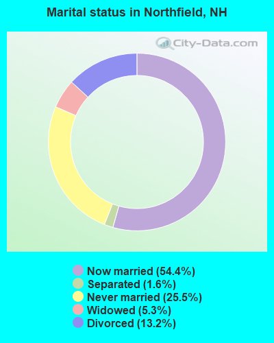
- Never married: 25.5%
- Now married: 54.4%
- Separated: 1.6%
- Widowed: 5.3%
- Divorced: 13.2%
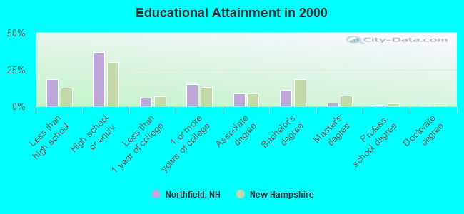
For population 25 years and over in Northfield:
- High school or higher: 81.6%
- Bachelor's degree or higher: 15.2%
- Graduate or professional degree: 4.0%
- Unemployed: 2.4%
- Mean travel time to work (commute): 25.4 minutes
| Here: | 10.3 |
| New Hampshire average: | 10.9 |
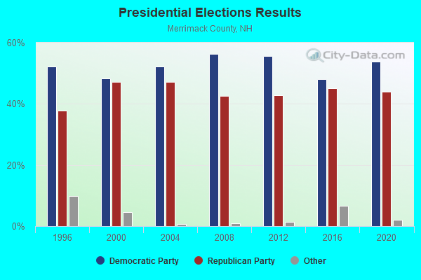
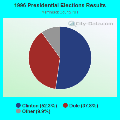
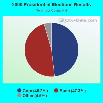
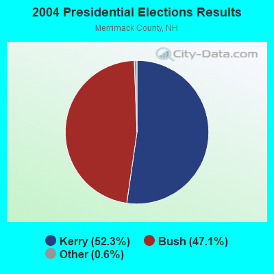

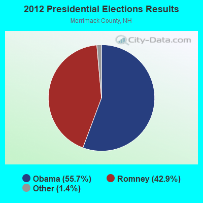
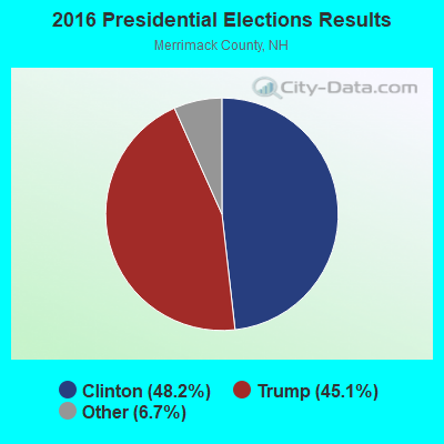
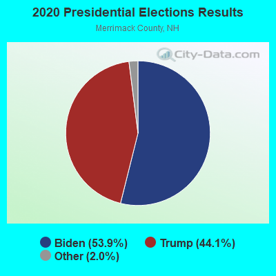
Graphs represent county-level data. Detailed 2008 Election Results
Religion statistics for Northfield, NH (based on Merrimack County data)
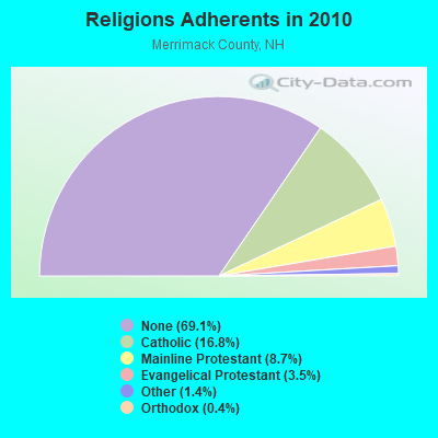
| Religion | Adherents | Congregations |
|---|---|---|
| Catholic | 24,654 | 7 |
| Mainline Protestant | 12,791 | 51 |
| Evangelical Protestant | 5,195 | 36 |
| Other | 2,097 | 15 |
| Orthodox | 580 | 2 |
| None | 101,128 | - |
Food Environment Statistics:
| This county: | 1.82 / 10,000 pop. |
| New Hampshire: | 2.14 / 10,000 pop. |
| Here: | 0.14 / 10,000 pop. |
| State: | 0.15 / 10,000 pop. |
| This county: | 1.22 / 10,000 pop. |
| State: | 1.78 / 10,000 pop. |
| This county: | 4.39 / 10,000 pop. |
| State: | 4.02 / 10,000 pop. |
| Here: | 7.77 / 10,000 pop. |
| New Hampshire: | 9.70 / 10,000 pop. |
| Merrimack County: | 7.4% |
| New Hampshire: | 7.6% |
| This county: | 23.8% |
| State: | 24.4% |
| Here: | 16.9% |
| State: | 15.9% |
Strongest AM radio stations in Northfield:
- WEZS (1350 AM; 5 kW; LACONIA, NH; Owner: GARY W. HAMMOND)
- WFTN (1240 AM; 1 kW; FRANKLIN, NH; Owner: NORTHEAST COMMUNICATIONS CORPORATION)
- WRKO (680 AM; 50 kW; BOSTON, MA; Owner: ENTERCOM BOSTON LICENSE, LLC)
- WNTK (1020 AM; 10 kW; NEWPORT, NH; Owner: KOOR COMMUNICATIONS, INC.)
- WGIN (930 AM; 10 kW; ROCHESTER, NH; Owner: CAPSTAR TX LIMITED PARTNERSHIP)
- WGIR (610 AM; 5 kW; MANCHESTER, NH; Owner: CAPSTAR TX LIMITED PARTNERSHIP)
- WEEI (850 AM; 50 kW; BOSTON, MA; Owner: ENTERCOM BOSTON LICENSE, LLC)
- WCRN (830 AM; 50 kW; WORCESTER, MA; Owner: CARTER BROADCASTING CORPORATION)
- WASR (1420 AM; 5 kW; WOLFEBORO, NH; Owner: RADIO WOLFEBORO, INC.)
- WNNZ (640 AM; 50 kW; WESTFIELD, MA; Owner: CLEAR CHANNEL BROADCASTING LICENSES, INC.)
- WKOX (1200 AM; 50 kW; FRAMINGHAM, MA; Owner: CAPSTAR TX LIMITED PARTNERSHIP)
- WEMJ (1490 AM; 1 kW; LACONIA, NH; Owner: WLNH RADIO, INC.)
- WBZ (1030 AM; 50 kW; BOSTON, MA; Owner: INFINITY BROADCASTING OPERATIONS, INC.)
Strongest FM radio stations in Northfield:
- WNHI (93.3 FM; BELMONT, NH; Owner: CONCORD BROADCASTING, L.L.C.)
- WFTN-FM (94.1 FM; FRANKLIN, NH; Owner: NORTHEAST COMMUNICATIONS CORPORATION)
- WLKZ (104.9 FM; WOLFEBORO, NH; Owner: TELE-MEDIA COMPANY OF NEW HAMPSHIRE, L.L.C.)
- WSCY (106.9 FM; MOULTONBOROUGH, NH; Owner: NORTHEAST COMMUNICATIONS CORPORATION)
- WJYY (105.5 FM; CONCORD, NH; Owner: CONCORD BROADCASTING, L.L.C.)
- WHDQ (106.1 FM; CLAREMONT, NH; Owner: GREAT NORTHERN RADIO, L.L.C.)
- WPNH-FM (100.1 FM; PLYMOUTH, NH; Owner: NORTHEAST COMMUNICATIONS CORPORATION)
- WPKQ (103.7 FM; NORTH CONWAY, NH; Owner: CITADEL BROADCASTING COMPANY)
- WVFM (105.7 FM; CAMPTON, NH; Owner: DEVON BROADCASTING COMPANY, INC.)
- WHOM (94.9 FM; MT. WASHINGTON, NH; Owner: CITADEL BROADCASTING COMPANY)
- WVNH (91.1 FM; CONCORD, NH; Owner: NEW HAMPSHIRE GOSPEL RADIO, INC.)
- WMEX (106.5 FM; FARMINGTON, NH; Owner: WIMMEX, LLC)
- W282AF (104.3 FM; CONCORD, NH; Owner: CONCORD BIBLE FELLOWSHIP)
- WVPR (89.5 FM; WINDSOR, VT; Owner: VERMONT PUBLIC RADIO)
- WLNH-FM (98.3 FM; LACONIA, NH; Owner: WLNH RADIO, INC)
- WNNH (99.1 FM; HENNIKER, NH; Owner: TELE-MEDIA COMPANY OF NEW HAMPSHIRE, L.L.C.)
- WBHG (101.5 FM; MEREDITH, NH; Owner: WLNH RADIO, INC)
- WNTK-FM (99.7 FM; NEW LONDON, NH; Owner: SHEILA E. VINIKOOR)
- WEVO (89.1 FM; CONCORD, NH; Owner: NEW HAMPSHIRE PUBLIC RADIO)
- WEVH (91.3 FM; HANOVER, NH; Owner: NEW HAMPSHIRE PUBLIC RADIO INC)
TV broadcast stations around Northfield:
- WMEA-TV (Channel 26; BIDDEFORD, ME; Owner: MAINE PUBLIC BROADCASTING CORP.)
- WMTW-TV (Channel 8; POLAND SPRING, ME; Owner: WMTW BROADCAST GROUP, LLC)
- WENH-TV (Channel 11; DURHAM, NH; Owner: UNIVERSITY OF NEW HAMPSHIRE)
- WPXG (Channel 21; CONCORD, NH; Owner: PAXSON BOSTON-68 LICENSE, INC.)
- National Bridge Inventory (NBI) Statistics
- 18Number of bridges
- 217ft / 65.5mTotal length
- $53,414,000Total costs
- 199,075Total average daily traffic
- 17,335Total average daily truck traffic
- New bridges - historical statistics
- 61950-1959
- 91960-1969
- 11980-1989
- 11990-1999
- 12010-2019
FCC Registered Cell Phone Towers:
2 (See the full list of FCC Registered Cell Phone Towers in Northfield)FCC Registered Antenna Towers:
10 (See the full list of FCC Registered Antenna Towers)FCC Registered Private Land Mobile Towers:
3 (See the full list of FCC Registered Private Land Mobile Towers in Northfield, NH)FCC Registered Broadcast Land Mobile Towers:
8 (See the full list of FCC Registered Broadcast Land Mobile Towers)FCC Registered Microwave Towers:
5- BEAN HILL/NORTHFIELD, Highland Ski Area Bean Hill (Lat: 43.397833 Lon: -71.550333), Type: Tower, Structure height: 54.8 m, Overall height: 60.3 m, Call Sign: WMJ781,
Assigned Frequencies: 10795.0 MHz, 10875.0 MHz, Grant Date: 01/19/2011, Expiration Date: 02/01/2021, Cancellation Date: 08/14/2015, Registrant: Verizon Wireless, 1120 Sanctuary Pkwy, #150 Gasa5reg, Alpharetta, GA 30009-7630, Phone: (770) 797-1070, Fax: (770) 797-1036, Email:
- Northfield 2, 308 Peverly Rd (Lat: 43.403417 Lon: -71.602222), Type: Tower, Structure height: 60.7 m, Call Sign: WQGC597,
Assigned Frequencies: 10627.5 MHz, Grant Date: 12/08/2006, Expiration Date: 12/08/2016, Cancellation Date: 02/25/2014, Certifier: Richard A Craig, Registrant: Verizon Wireless, 1120 Sanctuary Pkwy, #150 Gasa5reg, Alpharetta, GA 30009-7630, Phone: (770) 797-1070, Fax: (770) 797-1036, Email:
- BEAN HILL, Summit Bean Hill (Lat: 43.397778 Lon: -71.550056), Type: Tower, Structure height: 21 m, Call Sign: WQMP302,
Assigned Frequencies: 11645.0 MHz, 11645.0 MHz, 11645.0 MHz, 11645.0 MHz, 11645.0 MHz, 11645.0 MHz, 11645.0 MHz, 11645.0 MHz, 11645.0 MHz, 11645.0 MHz, 11605.0 MHz, Grant Date: 09/18/2020, Expiration Date: 10/12/2030, Certifier: John G Wynne, Registrant: Nh Dept Of Safety/Emergency Services & Communications, 33 Hazen Dr (Mailing), Concord, NH 03305, Phone: (603) 528-7541, Fax: (603) 271-6629, Email:
- Bean Hill, Highland Ski Area Bean Hill (Lat: 43.397778 Lon: -71.550278), Type: Tower, Structure height: 54.8 m, Overall height: 60.3 m, Call Sign: WQPB483,
Assigned Frequencies: 10915.0 MHz, 10915.0 MHz, 10915.0 MHz, 10915.0 MHz, Grant Date: 03/28/2012, Expiration Date: 03/28/2022, Cancellation Date: 05/28/2022, Certifier: John Wynne, Registrant: State Of Nh Homeland Security & Emergency Management, 110 Smokey Bear Blvd., Concord, NH 03301, Phone: (603) 223-3611, Fax: (603) 271-6337, Email:
- NORTHFIELD, 3.9 Mi Se (Lat: 43.406167 Lon: -71.529778), Overall height: 81.7 m, Call Sign: WHQ526,
Assigned Frequencies: 11245.0 MHz, 11285.0 MHz, 11405.0 MHz, 11525.0 MHz, 11325.0 MHz, 11365.0 MHz, 11485.0 MHz, 11405.0 MHz, 11445.0 MHz, 11645.0 MHz... (+5 more), Grant Date: 06/04/1987, Expiration Date: 09/10/1998, Cancellation Date: 09/10/1998, Registrant: New England Telephone And Telegraph Company, 125 High St Rm 515, Boston, MA 02110
FCC Registered Amateur Radio Licenses:
18 (See the full list of FCC Registered Amateur Radio Licenses in Northfield)FAA Registered Aircraft:
3- Aircraft: FLIGHT DESIGN GMBH CTSW (Category: Land, Seats: 2, Weight: Up to 12,499 Pounds), Engine: 4 Cycle
N-Number: 159CT, N159CT, N-159CT, Serial Number: 06-03-06, Certificate Issue Date: 07/05/2016
Registrant (Individual): Geoffrey Ziminsky, 465 Shaker Rd, Northfield, NH 03276 - Aircraft: STAR BALLOONS WORLD RECORD 4 (Category: Land, Weight: Up to 12,499 Pounds), Engine: AMA/EXPR UNKNOWN ENG (None)
N-Number: 41DT, N41DT, N-41DT, Serial Number: 41, Airworthiness Date: 01/24/1981, Certificate Issue Date: 10/25/2017
Registrant (Individual): Andrew S Fournier, 64 Union Rd, Northfield, NH 03276 - Aircraft: PIPER PA-28-160 (Category: Land, Seats: 4, Weight: Up to 12,499 Pounds, Speed: 107 mph), Engine: LYCOMING 0-320 SERIES (180 HP) (Reciprocating)
N-Number: 5155W, N5155W, N-5155W, Serial Number: 28-186, Year manufactured: 1961, Airworthiness Date: 11/17/1961, Certificate Issue Date: 07/20/2010
Registrant (Co-Owned): Richard S Robarge, 490 Concord Rd, Northfield, NH 03276, Other Owners: Katherine L Robarge
2003 - 2018 National Fire Incident Reporting System (NFIRS) incidents
- Fire incident types reported to NFIRS in Northfield, NH
- 31955.1%Structure Fires
- 17730.6%Outside Fires
- 5910.2%Mobile Property/Vehicle Fires
- 244.1%Other
 Based on the data from the years 2003 - 2018 the average number of fires per year is 36. The highest number of reported fires - 92 took place in 2015, and the least - 2 in 2003. The data has a growing trend.
 When looking into fire subcategories, the most incidents belonged to: Structure Fires (55.1%), and Outside Fires (30.6%).
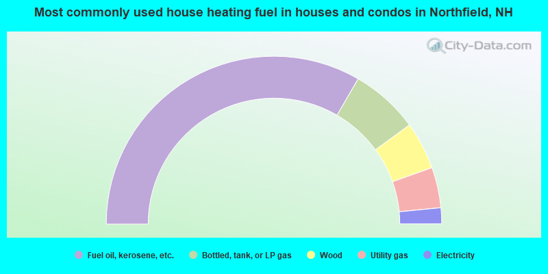
- 66.8%Fuel oil, kerosene, etc.
- 13.2%Bottled, tank, or LP gas
- 9.2%Wood
- 7.8%Utility gas
- 3.1%Electricity
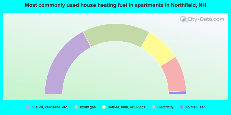
- 34.7%Fuel oil, kerosene, etc.
- 31.2%Utility gas
- 16.4%Bottled, tank, or LP gas
- 16.4%Electricity
- 1.3%No fuel used
Northfield compared to New Hampshire state average:
- Unemployed percentage significantly below state average.
- Hispanic race population percentage significantly below state average.
- Median age below state average.
- Foreign-born population percentage significantly below state average.
- Length of stay since moving in significantly above state average.
- Number of rooms per house significantly below state average.
- House age significantly below state average.
- Percentage of population with a bachelor's degree or higher below state average.
Northfield on our top lists:
- #35 on the list of "Top 101 cities with the largest percentage of people in residential treatment centers for emotionally disturbed children (population 1,000+)"
- #71 on the list of "Top 101 cities with the largest percentage of people in homes for abused, dependent, and neglected children (population 1,000+)"
- #30 on the list of "Top 101 counties with the lowest number of births per 1000 residents 2007-2013"
- #37 on the list of "Top 101 counties with the best general health status score of residents (1-5), 3 years of data"
- #46 on the list of "Top 101 counties with the highest percentage of residents that visited a dentist within the past year"
- #68 on the list of "Top 101 counties with the highest percentage of residents that keep firearms around their homes"
- #73 on the list of "Top 101 counties with the lowest Sulfur Oxides Annual air pollution readings in 2012 (µg/m3)"

|
|
Total of 20 patent applications in 2008-2024.