Oxford, Kansas
Submit your own pictures of this city and show them to the world
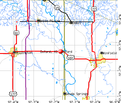
- OSM Map
- General Map
- Google Map
- MSN Map
Population change since 2000: -10.7%
 |
| Males: 470 | |
| Females: 578 |
| Median resident age: | 51.7 years |
| Kansas median age: | 37.6 years |
Zip codes: 67119.
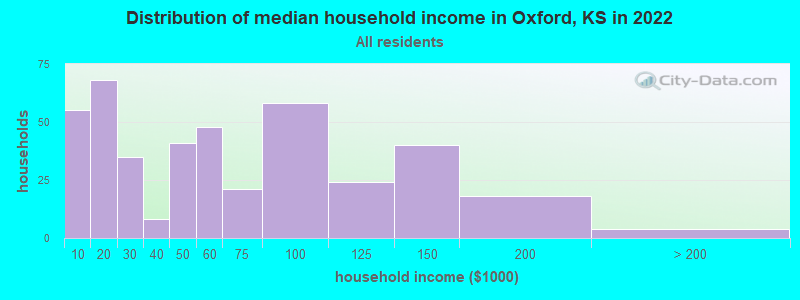
| Oxford: | $52,537 |
| KS: | $68,925 |
Estimated per capita income in 2022: $28,051 (it was $16,479 in 2000)
Oxford city income, earnings, and wages data
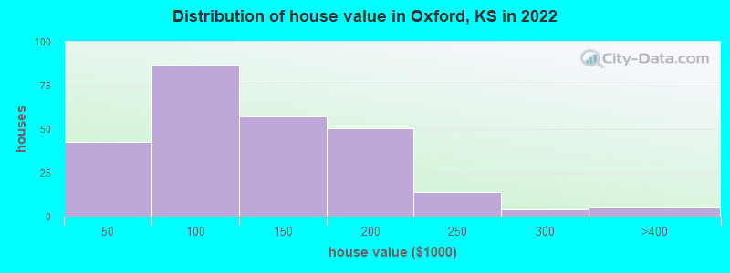
Estimated median house or condo value in 2022: $116,779 (it was $62,800 in 2000)
| Oxford: | $116,779 |
| KS: | $206,600 |
Mean prices in 2022: all housing units: $160,697; detached houses: $161,940; mobile homes: $71,717
Median gross rent in 2022: $420.
(12.8% for White Non-Hispanic residents, 100.0% for American Indian residents, 9.4% for two or more races residents)
Detailed information about poverty and poor residents in Oxford, KS
Compare current foreclosures near Oxford, KS:
| Photo | Address | Area | Beds / Baths | Price | Details |
|---|---|---|---|---|---|

|
#1
E Olive St
Oxford, KS 67119
|
1,796 sq. feet
|
2 baths 4 beds |
show details | |

|
#2
N Osage St
Oxford, KS 67119
|
2,384 sq. feet
|
3 baths 6 beds |
show details | |

|
#3
W Elm St
Oxford, KS 67119
|
- sq. feet
|
- baths - beds |
show details | |

|
#4
W Clark St
Oxford, KS 67119
|
- sq. feet
|
- baths - beds |
show details | |

|
#5
E 12th Ave
Winfield, KS 67156
|
- sq. feet
|
2 baths 3 beds |
$54,900
|
show details |

|
#6
N B St
Wellington, KS 67152
|
1,314 sq. feet
|
1 baths 2 beds |
show details | |

|
#7
Ann St
Winfield, KS 67156
|
1,015 sq. feet
|
1 baths 2 beds |
show details | |

|
#8
N Poplar St
Wellington, KS 67152
|
1,220 sq. feet
|
2 baths 2 beds |
show details | |

|
#9
E 7th Ave
Winfield, KS 67156
|
2,038 sq. feet
|
1 baths 3 beds |
show details | |

|
#10
Edgewood Dr
Wellington, KS 67152
|
1,464 sq. feet
|
2 baths 3 beds |
show details |
| Photo | Address | Area | Beds / Baths | Price | Details |
|---|---|---|---|---|---|

|
#11
N 10th St
Arkansas City, KS 67005
|
1,368 sq. feet
|
2 baths 3 beds |
show details | |

|
#12
S Oliver St
Mulvane, KS 67110
|
2,559 sq. feet
|
2 baths 2 beds |
show details | |

|
#13
Elizabeth St
Mulvane, KS 67110
|
1,453 sq. feet
|
1 baths 2 beds |
show details | |

|
#14
Lisa Ln
Mulvane, KS 67110
|
1,201 sq. feet
|
3 baths 2 beds |
show details | |

|
#15
Edgemont Dr
Arkansas City, KS 67005
|
1,560 sq. feet
|
1 baths 3 beds |
show details | |

|
#16
W College St
Wellington, KS 67152
|
1,742 sq. feet
|
2 baths 4 beds |
show details | |

|
#17
N 7th St
Arkansas City, KS 67005
|
1,836 sq. feet
|
1 baths 3 beds |
show details | |

|
#18
N 2nd St
Arkansas City, KS 67005
|
1,584 sq. feet
|
2 baths 2 beds |
show details | |

|
#19
N Olive St
Wellington, KS 67152
|
1,338 sq. feet
|
1 baths 2 beds |
show details | |

|
#20
N Olive St
Wellington, KS 67152
|
1,216 sq. feet
|
1 baths 3 beds |
show details |
| Photo | Address | Area | Beds / Baths | Price | Details |
|---|---|---|---|---|---|

|
#21
N Olive St
Wellington, KS 67152
|
759 sq. feet
|
2 baths 2 beds |
show details | |

|
#22
W 10th St
Wellington, KS 67152
|
964 sq. feet
|
1 baths 2 beds |
show details | |

|
#23
N B St
Arkansas City, KS 67005
|
1,560 sq. feet
|
1 baths 2 beds |
show details | |

|
#24
N Vandenburgh Ave
Wellington, KS 67152
|
1,084 sq. feet
|
1 baths 3 beds |
show details | |

|
#25
N B St
Wellington, KS 67152
|
1,184 sq. feet
|
1 baths 3 beds |
show details | |

|
#26
N C St
Wellington, KS 67152
|
988 sq. feet
|
1 baths 2 beds |
show details | |

|
#27
N A St
Wellington, KS 67152
|
2,008 sq. feet
|
2 baths 4 beds |
show details | |

|
#28
E 14th Ave
Winfield, KS 67156
|
1,041 sq. feet
|
1 baths 3 beds |
show details | |

|
#29
E South St
Wellington, KS 67152
|
1,456 sq. feet
|
2 baths 3 beds |
show details | |

|
#30
E 6th Ave
Winfield, KS 67156
|
1,064 sq. feet
|
1 baths 3 beds |
show details |
| Photo | Address | Area | Beds / Baths | Price | Details |
|---|---|---|---|---|---|

|
#31
Central Ave
Winfield, KS 67156
|
1,400 sq. feet
|
1 baths 3 beds |
show details | |

|
#32
E 10th Ave
Winfield, KS 67156
|
1,633 sq. feet
|
1 baths 2 beds |
show details | |

|
#33
Cherry St
Winfield, KS 67156
|
1,642 sq. feet
|
2 baths 3 beds |
show details | |

|
#34
W 14th Ave
Winfield, KS 67156
|
1,433 sq. feet
|
1 baths 3 beds |
show details | |

|
#35
N Sumner St
Belle Plaine, KS 67013
|
1,020 sq. feet
|
1 baths 2 beds |
show details | |

|
#36
E 12th Ave
Winfield, KS 67156
|
1,534 sq. feet
|
1 baths 3 beds |
show details | |

|
#37
N 1st St # 8
Arkansas City, KS 67005
|
- sq. feet
|
- baths - beds |
show details | |

|
#38
Shelly Dr
Mulvane, KS 67110
|
- sq. feet
|
- baths - beds |
show details | |

|
#39
N 7th St
Arkansas City, KS 67005
|
- sq. feet
|
- baths - beds |
show details | |

|
#40
Shelly Dr
Mulvane, KS 67110
|
- sq. feet
|
- baths - beds |
show details |
| Photo | Address | Area | Beds / Baths | Price | Details |
|---|---|---|---|---|---|

|
#41
N 3rd St
Arkansas City, KS 67005
|
- sq. feet
|
- baths - beds |
show details | |

|
#42
E Rock Road Ct Apt F5
Mulvane, KS 67110
|
- sq. feet
|
- baths - beds |
show details | |

|
#43
S 1st St # C
Arkansas City, KS 67005
|
- sq. feet
|
- baths - beds |
show details | |

|
#44
S 2nd St
Arkansas City, KS 67005
|
- sq. feet
|
- baths - beds |
show details | |

|
#45
Stewart St
Winfield, KS 67156
|
- sq. feet
|
- baths - beds |
show details | |

|
#46
N Lincoln St
Belle Plaine, KS 67013
|
- sq. feet
|
- baths - beds |
show details | |

|
#47
Manning St
Winfield, KS 67156
|
- sq. feet
|
- baths - beds |
show details | |

|
#48
N 9th St
Arkansas City, KS 67005
|
- sq. feet
|
- baths - beds |
show details | |

|
#49
N 13th St
Arkansas City, KS 67005
|
- sq. feet
|
- baths - beds |
show details | |

|
Check over 1 million property listings on Foreclosure.com!
|
browse all offers | |||


- 74885.7%White alone
- 697.9%Two or more races
- 232.6%Hispanic
- 192.2%Black alone
- 121.4%American Indian alone
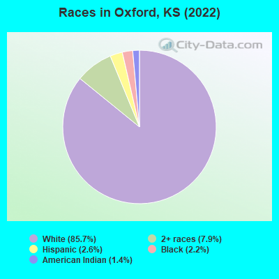
Races in Oxford detailed stats: ancestries, foreign born residents, place of birth
According to our research of Kansas and other state lists, there were 5 registered sex offenders living in Oxford, Kansas as of May 10, 2024.
The ratio of all residents to sex offenders in Oxford is 214 to 1.
Type |
2009 |
2010 |
2012 |
2013 |
2014 |
2015 |
2016 |
2017 |
2018 |
2019 |
2020 |
2021 |
2022 |
|---|---|---|---|---|---|---|---|---|---|---|---|---|---|
| Murders (per 100,000) | 0 (0.0) | 0 (0.0) | 0 (0.0) | 0 (0.0) | 0 (0.0) | 0 (0.0) | 0 (0.0) | 0 (0.0) | 0 (0.0) | 0 (0.0) | 0 (0.0) | 0 (0.0) | 0 (0.0) |
| Rapes (per 100,000) | 0 (0.0) | 2 (190.7) | 0 (0.0) | 0 (0.0) | 0 (0.0) | 1 (98.4) | 1 (98.1) | 0 (0.0) | 1 (99.3) | 1 (100.0) | 1 (100.6) | 0 (0.0) | 2 (190.8) |
| Robberies (per 100,000) | 0 (0.0) | 0 (0.0) | 1 (96.2) | 0 (0.0) | 0 (0.0) | 0 (0.0) | 0 (0.0) | 0 (0.0) | 0 (0.0) | 0 (0.0) | 0 (0.0) | 0 (0.0) | 0 (0.0) |
| Assaults (per 100,000) | 0 (0.0) | 0 (0.0) | 1 (96.2) | 0 (0.0) | 4 (394.5) | 0 (0.0) | 0 (0.0) | 3 (296.4) | 1 (99.3) | 3 (300.0) | 4 (402.4) | 0 (0.0) | 3 (286.3) |
| Burglaries (per 100,000) | 3 (283.8) | 12 (1,144) | 9 (865.4) | 0 (0.0) | 1 (98.6) | 5 (492.1) | 0 (0.0) | 6 (592.9) | 1 (99.3) | 0 (0.0) | 0 (0.0) | 1 (101.8) | 2 (190.8) |
| Thefts (per 100,000) | 4 (378.4) | 13 (1,239) | 13 (1,250) | 2 (196.1) | 2 (197.2) | 14 (1,378) | 2 (196.3) | 14 (1,383) | 4 (397.2) | 0 (0.0) | 2 (201.2) | 1 (101.8) | 7 (667.9) |
| Auto thefts (per 100,000) | 0 (0.0) | 1 (95.3) | 0 (0.0) | 0 (0.0) | 1 (98.6) | 0 (0.0) | 1 (98.1) | 4 (395.3) | 3 (297.9) | 1 (100.0) | 1 (100.6) | 0 (0.0) | 1 (95.4) |
| Arson (per 100,000) | 0 (0.0) | 0 (0.0) | 1 (96.2) | 0 (0.0) | 0 (0.0) | 0 (0.0) | 0 (0.0) | 0 (0.0) | 0 (0.0) | 0 (0.0) | 0 (0.0) | 0 (0.0) | 1 (95.4) |
| City-Data.com crime index | 35.0 | 289.8 | 158.7 | 7.8 | 101.6 | 168.3 | 94.2 | 187.7 | 146.0 | 148.0 | 177.1 | 11.2 | 257.6 |
The City-Data.com crime index weighs serious crimes and violent crimes more heavily. Higher means more crime, U.S. average is 246.1. It adjusts for the number of visitors and daily workers commuting into cities.
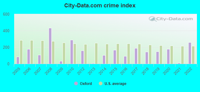
Crime rate in Oxford detailed stats: murders, rapes, robberies, assaults, burglaries, thefts, arson
Full-time law enforcement employees in 2020, including police officers: 3 (3 officers - 3 male; 0 female).
| Officers per 1,000 residents here: | 3.02 |
| Kansas average: | 2.66 |
 Recent articles from our blog. Our writers, many of them Ph.D. graduates or candidates, create easy-to-read articles on a wide variety of topics.

 | Kansas gubernatorial election, 2018 (26 candidates so far) (89 replies) |
| Homeschoolers in Oxford, Wellington, Winfield area (1 reply) |
| So, what do you LOVE about Kansas? (73 replies) |
| Moving to Winfield or Arkansas City in July (14 replies) |
Latest news from Oxford, KS collected exclusively by city-data.com from local newspapers, TV, and radio stations
Ancestries: German (17.6%), Irish (16.7%), American (15.0%), English (10.3%), Scottish (2.9%), Czechoslovakian (2.1%).
Current Local Time: CST time zone
Elevation: 1185 feet
Land area: 0.84 square miles.
Population density: 1,252 people per square mile (low).
5 residents are foreign born
| This city: | 0.6% |
| Kansas: | 7.1% |
Median real estate property taxes paid for housing units with mortgages in 2022: $1,765 (1.4%)
Median real estate property taxes paid for housing units with no mortgage in 2022: $1,793 (1.7%)
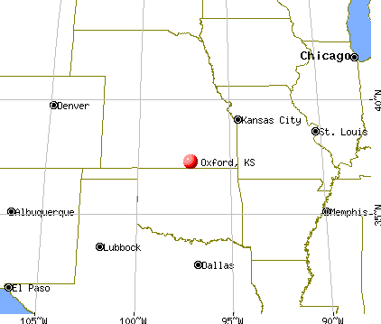
Nearest city with pop. 50,000+: Wichita, KS  (30.1 miles , pop. 344,284).
Nearest city with pop. 1,000,000+: Dallas, TX (310.3 miles , pop. 1,188,580).
Nearest cities:
), )Latitude: 37.27 N, Longitude: 97.17 W
Area code: 620
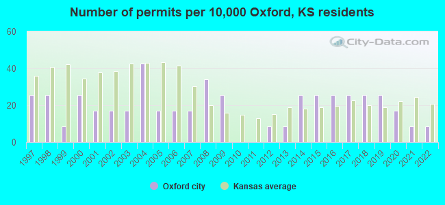
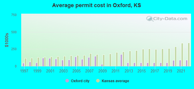
Single-family new house construction building permits:
- 2022: 1 building, cost: $90,000
- 2021: 1 building, cost: $90,000
- 2020: 2 buildings, average cost: $87,500
- 2019: 3 buildings, average cost: $52,700
- 2018: 3 buildings, average cost: $52,700
- 2017: 3 buildings, average cost: $52,700
- 2016: 3 buildings, average cost: $52,700
- 2015: 3 buildings, average cost: $52,700
- 2014: 3 buildings, average cost: $52,700
- 2013: 1 building, cost: $52,000
- 2012: 1 building, cost: $174,000
- 2009: 3 buildings, average cost: $32,300
- 2008: 4 buildings, average cost: $148,800
- 2007: 2 buildings, average cost: $127,500
- 2006: 2 buildings, average cost: $105,000
- 2005: 2 buildings, average cost: $137,500
- 2004: 5 buildings, average cost: $95,200
- 2003: 2 buildings, average cost: $90,000
- 2002: 2 buildings, average cost: $108,500
- 2001: 2 buildings, average cost: $117,500
- 2000: 3 buildings, average cost: $123,300
- 1999: 1 building, cost: $50,000
- 1998: 3 buildings, average cost: $67,000
- 1997: 3 buildings, average cost: $46,000
| Here: | 2.1% |
| Kansas: | 2.0% |
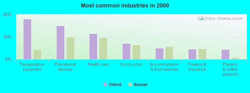
- Transportation equipment (17.9%)
- Educational services (14.9%)
- Health care (11.4%)
- Construction (7.0%)
- Accommodation & food services (5.0%)
- Finance & insurance (4.6%)
- Plastics & rubber products (4.4%)
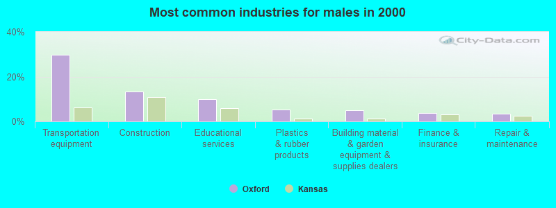
- Transportation equipment (29.7%)
- Construction (13.3%)
- Educational services (9.8%)
- Plastics & rubber products (5.2%)
- Building material & garden equipment & supplies dealers (4.9%)
- Finance & insurance (3.8%)
- Repair & maintenance (3.5%)
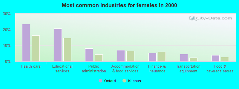
- Health care (23.4%)
- Educational services (20.7%)
- Public administration (8.2%)
- Accommodation & food services (7.0%)
- Finance & insurance (5.5%)
- Transportation equipment (4.7%)
- Food & beverage stores (3.9%)
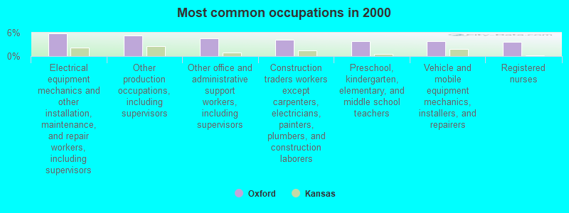
- Electrical equipment mechanics and other installation, maintenance, and repair workers, including supervisors (5.9%)
- Other production occupations, including supervisors (5.4%)
- Other office and administrative support workers, including supervisors (4.6%)
- Construction traders workers except carpenters, electricians, painters, plumbers, and construction laborers (4.2%)
- Preschool, kindergarten, elementary, and middle school teachers (3.9%)
- Vehicle and mobile equipment mechanics, installers, and repairers (3.9%)
- Registered nurses (3.7%)
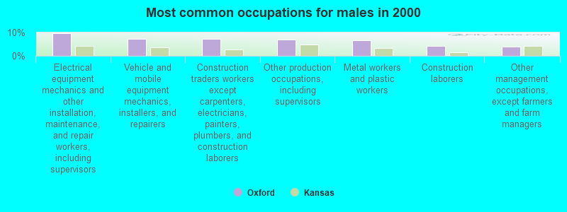
- Electrical equipment mechanics and other installation, maintenance, and repair workers, including supervisors (9.8%)
- Vehicle and mobile equipment mechanics, installers, and repairers (7.3%)
- Construction traders workers except carpenters, electricians, painters, plumbers, and construction laborers (7.3%)
- Other production occupations, including supervisors (7.0%)
- Metal workers and plastic workers (6.6%)
- Construction laborers (4.2%)
- Other management occupations, except farmers and farm managers (3.8%)
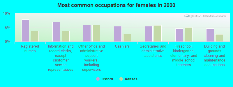
- Registered nurses (7.8%)
- Information and record clerks, except customer service representatives (7.0%)
- Other office and administrative support workers, including supervisors (5.9%)
- Cashiers (5.5%)
- Secretaries and administrative assistants (5.5%)
- Preschool, kindergarten, elementary, and middle school teachers (4.7%)
- Building and grounds cleaning and maintenance occupations (4.7%)
Average climate in Oxford, Kansas
Based on data reported by over 4,000 weather stations


|
|

(lower is better)
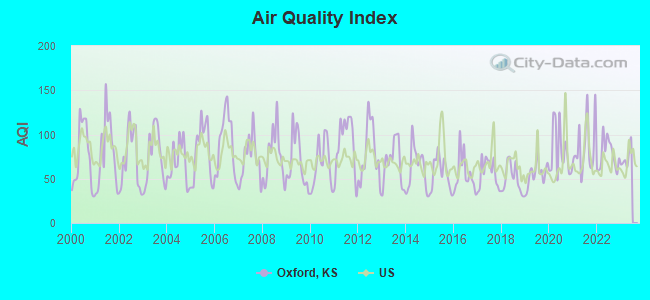
Air Quality Index (AQI) level in 2022 was 77.3. This is about average.
| City: | 77.3 |
| U.S.: | 72.6 |
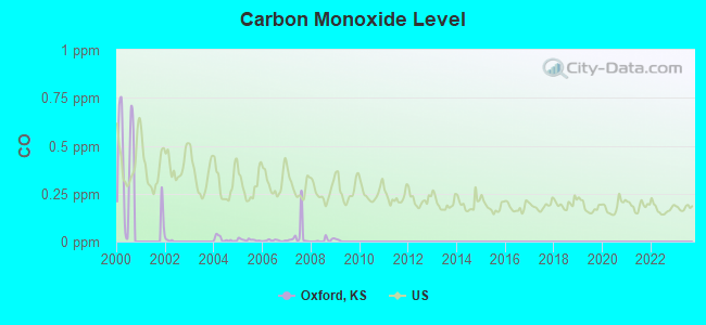
Carbon Monoxide (CO) [ppm] level in 2008 was 0.00714. This is significantly better than average. Closest monitor was 17.7 miles away from the city center.
| City: | 0.00714 |
| U.S.: | 0.25132 |
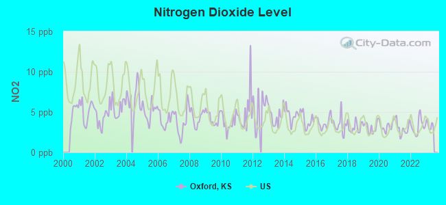
Nitrogen Dioxide (NO2) [ppb] level in 2022 was 3.21. This is significantly better than average. Closest monitor was 16.9 miles away from the city center.
| City: | 3.21 |
| U.S.: | 5.11 |
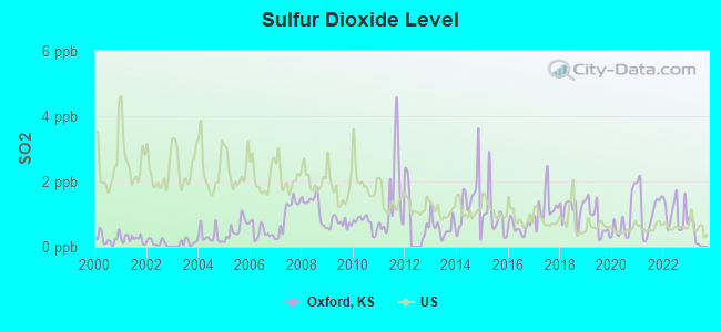
Sulfur Dioxide (SO2) [ppb] level in 2022 was 1.02. This is significantly better than average. Closest monitor was 16.9 miles away from the city center.
| City: | 1.02 |
| U.S.: | 1.51 |
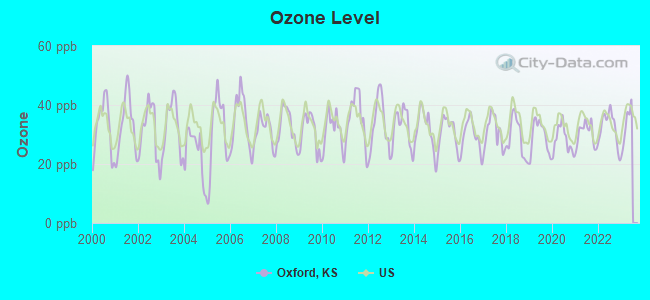
Ozone [ppb] level in 2022 was 32.4. This is about average. Closest monitor was 17.7 miles away from the city center.
| City: | 32.4 |
| U.S.: | 33.3 |
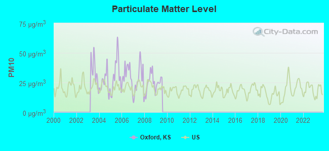
Particulate Matter (PM10) [µg/m3] level in 2009 was 25.5. This is worse than average. Closest monitor was 23.3 miles away from the city center.
| City: | 25.5 |
| U.S.: | 19.2 |
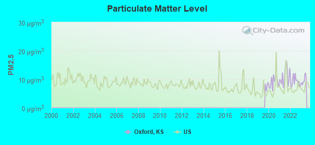
Particulate Matter (PM2.5) [µg/m3] level in 2022 was 9.17. This is about average. Closest monitor was 17.7 miles away from the city center.
| City: | 9.17 |
| U.S.: | 8.11 |
Tornado activity:
Oxford-area historical tornado activity is near Kansas state average. It is 108% greater than the overall U.S. average.
On 4/26/1991, a category F5 (max. wind speeds 261-318 mph) tornado 21.7 miles away from the Oxford city center killed 17 people and injured 225 people and caused between $50,000,000 and $500,000,000 in damages.
On 5/25/1955, a category F5 tornado 22.9 miles away from the city center killed 20 people and injured 280 people and caused between $5,000,000 and $50,000,000 in damages.
Earthquake activity:
Oxford-area historical earthquake activity is significantly above Kansas state average. It is 870% greater than the overall U.S. average.On 9/3/2016 at 12:02:44, a magnitude 5.8 (5.8 MW, Depth: 3.5 mi, Class: Moderate, Intensity: VI - VII) earthquake occurred 60.3 miles away from the city center
On 11/6/2011 at 03:53:10, a magnitude 5.7 (5.7 MW, Depth: 3.2 mi) earthquake occurred 122.6 miles away from Oxford center
On 11/12/2014 at 21:40:00, a magnitude 4.9 (4.9 MW, Depth: 2.5 mi, Class: Light, Intensity: IV - V) earthquake occurred 24.8 miles away from Oxford center
On 2/13/2016 at 17:07:06, a magnitude 5.1 (5.1 MW, Depth: 5.2 mi) earthquake occurred 101.0 miles away from Oxford center
On 11/7/2016 at 01:44:24, a magnitude 5.0 (5.0 MW, Depth: 2.8 mi) earthquake occurred 91.1 miles away from Oxford center
On 11/30/2015 at 09:49:12, a magnitude 4.7 (4.7 MW, Depth: 3.5 mi) earthquake occurred 60.9 miles away from the city center
Magnitude types: moment magnitude (MW)
Natural disasters:
The number of natural disasters in Sumner County (20) is greater than the US average (15).Major Disasters (Presidential) Declared: 15
Emergencies Declared: 2
Causes of natural disasters: Floods: 14, Storms: 14, Tornadoes: 9, Winds: 6, Winter Storms: 3, Heavy Rain: 1, Hurricane: 1, Ice Storm: 1, Landslide: 1, Mudslide: 1, Snow: 1, Other: 1 (Note: some incidents may be assigned to more than one category).
Hospitals and medical centers in Oxford:
Other hospitals and medical centers near Oxford:
- PARADISE VALLEY CARE CENTER (Nursing Home, about 11 miles away; BELLE PLAINE, KS)
- WINFIELD DIALYSIS CENTER (Dialysis Facility, about 11 miles away; WINFIELD, KS)
- CUMBERNAULD VILLAGE (Nursing Home, about 11 miles away; WINFIELD, KS)
- WINFIELD REST HAVEN II, LLC (Nursing Home, about 11 miles away; WINFIELD, KS)
- GOOD SAMARITAN SOCIETY - WINFIELD (Nursing Home, about 12 miles away; WINFIELD, KS)
- GOOD SAMARITAN VILLAGE (Nursing Home, about 12 miles away; WINFIELD, KS)
- SUMNER REGIONAL MEDICAL CENTER SNF (Nursing Home, about 13 miles away; WELLINGTON, KS)
Airports located in Oxford:
- Oxford Municipal Airport (55K) (Runways: 1, Itinerant Ops: 1,000, Local Ops: 1,500)
Colleges/universities with over 2000 students nearest to Oxford:
- Cowley County Community College (about 17 miles; Arkansas City, KS; Full-time enrollment: 3,173)
- Wichita Technical Institute (about 29 miles; Wichita, KS; FT enrollment: 2,015)
- Newman University (about 30 miles; Wichita, KS; FT enrollment: 2,066)
- Friends University (about 30 miles; Wichita, KS; FT enrollment: 2,024)
- Wichita State University (about 32 miles; Wichita, KS; FT enrollment: 11,743)
- Wichita Area Technical College (about 34 miles; Wichita, KS; FT enrollment: 2,220)
- Butler Community College (about 40 miles; El Dorado, KS; FT enrollment: 6,676)
Public elementary/middle school in Oxford:
- OXFORD ELEM (Students: 188, Location: 319 E COLLEGE, Grades: PK-6)
Points of interest:
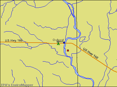
Notable locations in Oxford: Oxford Sewer Treatment Plant (A), Oxford Police Department (B), Sumner County Fire District 3 Oxford (C), Oxford Public Library (D), Oxford City Hall (E), Oxford Friendship Center (F). Display/hide their locations on the map
Churches in Oxford include: Church of Christ (A), First Baptist Church (B), Maple Street Baptist Church (C), Oxford Christian Church (D), Oxford United Methodist Church (E), Saint Mary's Catholic Church (F). Display/hide their locations on the map
| This city: | 2.3 people |
| Kansas: | 2.5 people |
| This city: | 67.3% |
| Whole state: | 66.0% |
| This city: | 4.8% |
| Whole state: | 5.8% |
Likely homosexual households (counted as self-reported same-sex unmarried-partner households)
- Lesbian couples: 0.0% of all households
- Gay men: 0.2% of all households
45 people in nursing homes in 2000
Banks with branches in Oxford (2011 data):
- Cornerbank, National Association: Oxford Branch at 101 North Sumner, branch established on 1883/11/15. Info updated 2006/11/03: Bank assets: $276.8 mil, Deposits: $206.0 mil, headquarters in Winfield, KS, positive income, Agricultural Specialization, 10 total offices, Holding Company: Cornerstone Alliance, Ltd.
- Emerald Bank: Oxford Branch at 305 East Main, branch established on 1993/02/01. Info updated 2010/09/28: Bank assets: $16.7 mil, Deposits: $15.2 mil, headquarters in Burden, KS, positive income, Consumer Lending Specialization, 2 total offices
For population 15 years and over in Oxford:
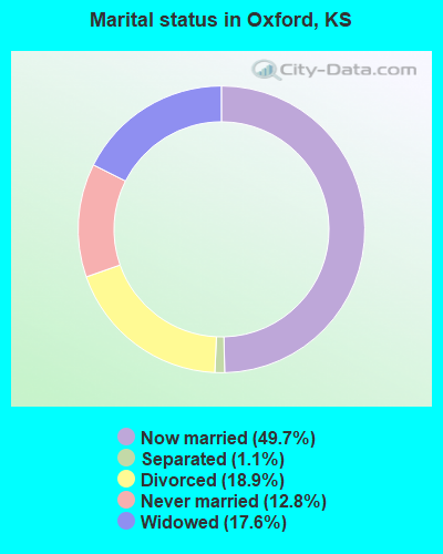
- Never married: 12.8%
- Now married: 49.7%
- Separated: 1.1%
- Widowed: 17.6%
- Divorced: 18.9%
For population 25 years and over in Oxford:
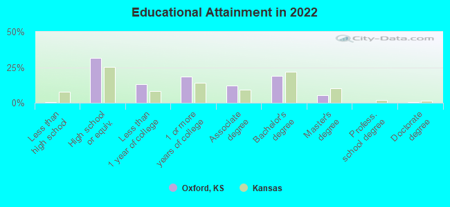
- High school or higher: 99.2%
- Bachelor's degree or higher: 23.6%
- Graduate or professional degree: 5.1%
- Unemployed: 3.7%
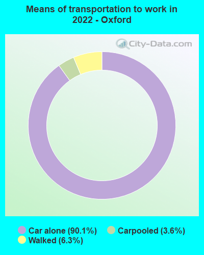
- Mean travel time to work (commute): 35.4 minutes
| Here: | 7.0 |
| Kansas average: | 11.5 |
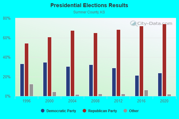
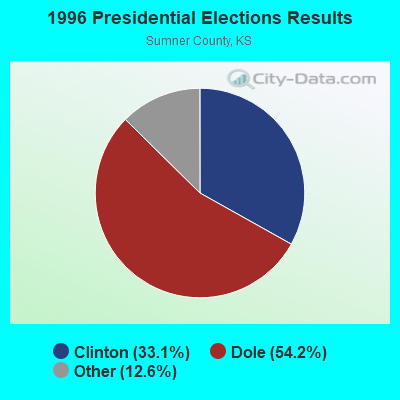
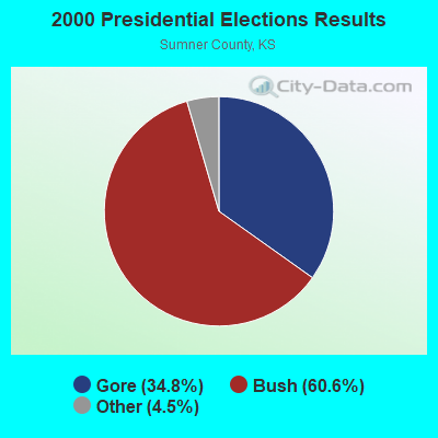

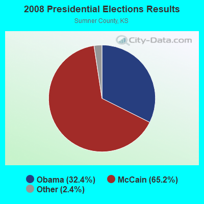
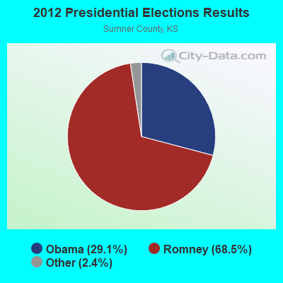
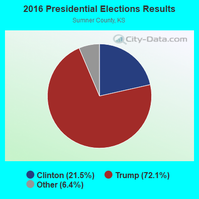
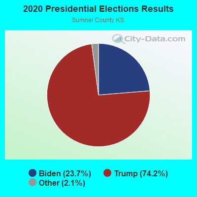
Graphs represent county-level data. Detailed 2008 Election Results
Religion statistics for Oxford, KS (based on Sumner County data)
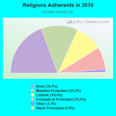
| Religion | Adherents | Congregations |
|---|---|---|
| Mainline Protestant | 6,073 | 28 |
| Catholic | 4,500 | 4 |
| Evangelical Protestant | 3,731 | 28 |
| Other | 350 | 2 |
| Black Protestant | 187 | 1 |
| None | 9,291 | - |
Food Environment Statistics:
| This county: | 2.52 / 10,000 pop. |
| State: | 1.96 / 10,000 pop. |
| Sumner County: | 4.20 / 10,000 pop. |
| Kansas: | 3.84 / 10,000 pop. |
| Sumner County: | 6.30 / 10,000 pop. |
| State: | 7.33 / 10,000 pop. |
| Sumner County: | 9.2% |
| Kansas: | 8.1% |
| This county: | 28.8% |
| Kansas: | 27.9% |
| Here: | 8.5% |
| Kansas: | 13.4% |
Health and Nutrition:
| Oxford: | 52.6% |
| Kansas: | 49.2% |
| Oxford: | 49.3% |
| Kansas: | 46.3% |
| This city: | 28.5 |
| Kansas: | 28.6 |
| This city: | 20.4% |
| Kansas: | 21.2% |
| Oxford: | 10.5% |
| State: | 10.5% |
| Oxford: | 6.9 |
| Kansas: | 6.8 |
| Oxford: | 35.5% |
| Kansas: | 33.5% |
| Oxford: | 57.5% |
| Kansas: | 56.0% |
| Oxford: | 77.3% |
| Kansas: | 78.6% |
More about Health and Nutrition of Oxford, KS Residents
| Local government employment and payroll (March 2022) | |||||
| Function | Full-time employees | Monthly full-time payroll | Average yearly full-time wage | Part-time employees | Monthly part-time payroll |
|---|---|---|---|---|---|
| Water Supply | 5 | $18,068 | $43,363 | 0 | $0 |
| Electric Power | 5 | $24,034 | $57,682 | 0 | $0 |
| Police Protection - Officers | 3 | $9,858 | $39,432 | 2 | $1,632 |
| Other and Unallocable | 3 | $9,902 | $39,608 | 0 | $0 |
| Streets and Highways | 3 | $11,718 | $46,872 | 0 | $0 |
| Sewerage | 3 | $9,220 | $36,880 | 0 | $0 |
| Financial Administration | 1 | $5,232 | $62,784 | 1 | $619 |
| Other Government Administration | 0 | $0 | 1 | $400 | |
| Local Libraries | 0 | $0 | 4 | $5,512 | |
| Judicial and Legal | 0 | $0 | 1 | $187 | |
| Police - Other | 0 | $0 | 1 | $705 | |
| Totals for Government | 23 | $88,032 | $45,930 | 10 | $9,055 |
Oxford government finances - Expenditure in 2017 (per resident):
- Construction - Regular Highways: $251,000 ($239.50)
Water Utilities: $41,000 ($39.12)
Electric Utilities: $34,000 ($32.44)
Sewerage: $15,000 ($14.31)
Parks and Recreation: $6,000 ($5.73)
Police Protection: $4,000 ($3.82)
Central Staff Services: $3,000 ($2.86)
Libraries: $3,000 ($2.86)
- Current Operations - Electric Utilities: $995,000 ($949.43)
Police Protection: $265,000 ($252.86)
Water Utilities: $127,000 ($121.18)
Solid Waste Management: $126,000 ($120.23)
Central Staff Services: $81,000 ($77.29)
Parks and Recreation: $64,000 ($61.07)
Air Transportation: $57,000 ($54.39)
Libraries: $46,000 ($43.89)
Regular Highways: $34,000 ($32.44)
Sewerage: $30,000 ($28.63)
Financial Administration: $10,000 ($9.54)
Health - Other: $6,000 ($5.73)
Judicial and Legal Services: $2,000 ($1.91)
- General - Interest on Debt: $3,000 ($2.86)
- Other Capital Outlay - Electric Utilities: $12,000 ($11.45)
Water Utilities: $8,000 ($7.63)
Police Protection: $5,000 ($4.77)
Regular Highways: $1,000 ($0.95)
Solid Waste Management: $1,000 ($0.95)
Parks and Recreation: $1,000 ($0.95)
- Total Salaries and Wages: $551,000 ($525.76)
Oxford government finances - Revenue in 2017 (per resident):
- Charges - Solid Waste Management: $127,000 ($121.18)
Natural Resources - Other: $81,000 ($77.29)
Sewerage: $57,000 ($54.39)
Parks and Recreation: $28,000 ($26.72)
- Local Intergovernmental - Highways: $6,000 ($5.73)
Health and Hospitals: $2,000 ($1.91)
- Miscellaneous - Rents: $6,000 ($5.73)
Interest Earnings: $3,000 ($2.86)
Fines and Forfeits: $3,000 ($2.86)
Royalties: $2,000 ($1.91)
- Revenue - Electric Utilities: $1,013,000 ($966.60)
Water Utilities: $144,000 ($137.40)
- State Intergovernmental - Highways: $27,000 ($25.76)
- Tax - Property: $227,000 ($216.60)
General Sales and Gross Receipts: $57,000 ($54.39)
Motor Vehicle License: $48,000 ($45.80)
Public Utilities Sales: $23,000 ($21.95)
Public Utility License: $16,000 ($15.27)
Other Selective Sales: $12,000 ($11.45)
Occupation and Business License - Other: $1,000 ($0.95)
Oxford government finances - Debt in 2017 (per resident):
- Long Term Debt - Beginning Outstanding - Unspecified Public Purpose: $70,000 ($66.79)
Retired Unspecified Public Purpose: $70,000 ($66.79)
Oxford government finances - Cash and Securities in 2017 (per resident):
- Other Funds - Cash and Securities: $1,553,000 ($1481.87)
Strongest AM radio stations in Oxford:
- KFTI (1070 AM; 10 kW; WICHITA, KS; Owner: JOURNAL BROADCAST CORPORATION)
- KRMG (740 AM; 50 kW; TULSA, OK; Owner: CXR HOLDINGS, INC.)
- KFH (1330 AM; 5 kW; WICHITA, KS; Owner: ENTERCOM WICHITA LICENSE, LLC)
- KFAQ (1170 AM; 50 kW; TULSA, OK; Owner: JOURNAL BROADCAST CORPORATION)
- KSOK (1280 AM; daytime; 1 kW; ARKANSAS CITY, KS; Owner: COWLEY COUNTY BROADCASTING, INC.)
- KQAM (1480 AM; 5 kW; WICHITA, KS; Owner: ABC, INC.)
- KMYR (1410 AM; 5 kW; WICHITA, KS; Owner: AGAPE COMMUNICATIONS, INC.)
- KKLE (1550 AM; 0 kW; WINFILED, KS; Owner: JOHNSON ENTERPRISES, INC)
- KOMA (1520 AM; 50 kW; OKLAHOMA CITY, OK; Owner: RENDA BROADCASTING CORP. OF NEVADA)
- KTBZ (1430 AM; 25 kW; TULSA, OK; Owner: CLEAR CHANNEL BROADCASTING LICENSES, INC.)
- KMUS (1380 AM; 20 kW; MUSKOGEE, OK; Owner: ABC, INC.)
- KGGF (690 AM; 10 kW; COFFEYVILLE, KS; Owner: KGGF-KUSN, INC.)
- WHB (810 AM; 50 kW; KANSAS CITY, MO; Owner: UNION BROADCASTING, INC.)
Strongest FM radio stations in Oxford:
- KYQQ (106.5 FM; ARKANSAS CITY, KS; Owner: JOURNAL BROADCAST CORPORATION)
- KANR (92.7 FM; BELLE PLAINE, KS; Owner: DANIEL D. SMITH)
- KBDD (91.9 FM; WINFILED, KS; Owner: AMERICAN FAMILY ASSOCIATION)
- KZZD (90.7 FM; WICHITA, KS; Owner: WORD OF LIFE MINISTRIES, INC.)
- KWME (93.5 FM; WELLINGTON, KS; Owner: JOHNSON ENTERPRISES, INC.)
- KSJM (107.9 FM; WINFIELD, KS; Owner: SHERMAN BROADCAST GROUP INC.)
- KSOK-FM (95.9 FM; WINFIELD, KS; Owner: COWLEY COUNTY BROADCASTING, INC.)
- KEYN-FM (103.7 FM; WICHITA, KS; Owner: ENTERCOM WICHITA LICENSE, LLC)
- KFDI-FM (101.3 FM; WICHITA, KS; Owner: JOURNAL BROADCAST CORPORATION)
- KRBB (97.9 FM; WICHITA, KS; Owner: CAPSTAR TX LIMITED PARTNERSHIP)
- KFBZ (105.3 FM; HAYSVILLE, KS; Owner: ENTERCOM WICHITA LICENSE, LLC)
- KZSN (102.1 FM; HUTCHINSON, KS; Owner: CAPSTAR TX LIMITED PARTNERSHIP)
- KICT-FM (95.1 FM; WICHITA, KS; Owner: JOURNAL BROADCAST CORPORATION)
- KFH-FM (98.7 FM; CLEARWATER, KS; Owner: ENTERCOM WICHITA LICENSE, LLC)
- KACY (102.5 FM; ARKANSAS CITY, KS; Owner: THIRD COAST BROADCASTING, INC.)
- KKRD (107.3 FM; WICHITA, KS; Owner: CAPSTAR TX LIMITED PARTNERSHIP)
- KDGS (93.9 FM; ANDOVER, KS; Owner: ENTERCOM WICHITA LICENSE, LLC)
- KAXR (91.3 FM; ARKANSAS CITY, KS; Owner: AMERICAN FAMILY ASSOCIATION)
TV broadcast stations around Oxford:
- KSNW (Channel 3; WICHITA, KS; Owner: EMMIS TELEVISION LICENSE CORPORATION OF WICHITA)
- KSAS-TV (Channel 24; WICHITA, KS; Owner: CLEAR CHANNEL BROADCASTING LICENSES, INC.)
- KTQW-LP (Channel 53; WICHITA, KS; Owner: KNOWLEDGE L.C.)
- KWCV (Channel 33; WICHITA, KS; Owner: WLBB BROADCASTING, L.L.C.)
- KAKE-TV (Channel 10; WICHITA, KS; Owner: GRAY MIDAMERICA TV LICENSEE CORP.)
Oxford fatal accident list:
Aug 2, 2002 00:40 AM, Us-160, Vehicles: 2, Persons: 3, Fatalities: 2, Drunk persons involved: 1
- National Bridge Inventory (NBI) Statistics
- 27Number of bridges
- 246ft / 75.3mTotal length
- $60,000Total costs
- 24,313Total average daily traffic
- 3,189Total average daily truck traffic
- 31,168Total future (year 2039) average daily traffic
- New bridges - historical statistics
- 71930-1939
- 11940-1949
- 11950-1959
- 21960-1969
- 21970-1979
- 41980-1989
- 41990-1999
- 52000-2009
- 12010-2019
FCC Registered Antenna Towers:
16 (See the full list of FCC Registered Antenna Towers in Oxford)FCC Registered Broadcast Land Mobile Towers:
7- 412 S Webb Rd (Lat: 37.274194 Lon: -97.178083), Type: Building, Structure height: 3 m, Call Sign: WPIP219,
Assigned Frequencies: 173.210 MHz, Grant Date: 07/21/2015, Expiration Date: 10/02/2025, Certifier: Wayne De Mint, Registrant: Federal License Management, 1784 E. 3rd Street Suite 269, Williamsport, PA 17701-3862, Phone: (570) 505-3894, Fax: (570) 651-9032, Email:
- 1/2 Mi N (Lat: 37.279194 Lon: -97.170306), Call Sign: WXY715, Licensee ID: L00055372,
Assigned Frequencies: 153.005 MHz, Grant Date: 09/15/1998, Expiration Date: 11/16/2003, Cancellation Date: 01/18/2004, Registrant: Wendell Buss, Rr 1 Box 48, Oxford, KS 67119
- Elevated Water Tower 1/2 Mi N (Lat: 37.281972 Lon: -97.168083), Call Sign: KNGE281, Licensee ID: L00028335,
Assigned Frequencies: 173.390 MHz, Grant Date: 02/04/1998, Expiration Date: 04/21/2003, Cancellation Date: 07/27/2003, Registrant: City Of Oxford, 121 S Sumner, Oxford, KS 67119
- Well House 5 1/4 Mi N & 1 Mi W (Lat: 37.361417 Lon: -97.188083), Call Sign: KNGE282, Licensee ID: L00028335,
Assigned Frequencies: 173.390 MHz, Grant Date: 02/04/1998, Expiration Date: 04/21/2003, Cancellation Date: 07/27/2003, Registrant: City Of Oxford, 121 S Sumner, Oxford, KS 67119
- City Hall 200 S Sumner St (Lat: 37.273361 Lon: -97.168917), Call Sign: KNGE283, Licensee ID: L00028335,
Assigned Frequencies: 173.390 MHz, Grant Date: 02/05/1998, Expiration Date: 04/21/2003, Cancellation Date: 07/27/2003, Registrant: City Of Oxford, 121 S Sumner, Oxford, KS 67119
- Well House, 5 1/4 Mile N & 1 Mile W Of Oxford (Lat: 37.361417 Lon: -97.188083), Type: Bant, Structure height: 5 m, Overall height: 6 m, Call Sign: WQAJ506,
Assigned Frequencies: 173.390 MHz, Grant Date: 04/16/2014, Expiration Date: 06/15/2024, Certifier: Robert Spoon, Registrant: Comm-Tronix, 1735 Mccormick, Wichita, KS 67213, Phone: (316) 263-5958, Fax: (316) 263-4881, Email:
- Lat: 37.279111 Lon: -97.165528, Call Sign: WRHW446,
Assigned Frequencies: 72.1000 MHz, Grant Date: 06/30/2020, Expiration Date: 06/30/2030, Certifier: Scott Smythe, Registrant: Primex Wireless, Inc., 965 Wells St., Lake Geneva, WI 53147, Phone: (262) 249-2327, Fax: (262) 248-0061, Email:
FCC Registered Microwave Towers:
7- Oxford, KS, Lat: 37.334000 Lon: -97.169000, Call Sign: WQFA630,
Assigned Frequencies: 956.406 MHz, 956.406 MHz, Grant Date: 06/17/2016, Expiration Date: 06/01/2026, Certifier: Jeremy M Krueger, Registrant: One Gas, Inc., 15 E 5th Street, Tulsa, OK 74121, Phone: (918) 947-7143, Email:
- Oxford Alpha, Lat: 37.244722 Lon: -97.174167, Type: Gtower, Structure height: 115.8 m, Overall height: 121.9 m, Call Sign: WQKR605,
Assigned Frequencies: 3650.00 MHz, Grant Date: 08/06/2019, Expiration Date: 06/14/2021, Cancellation Date: 06/25/2021, Certifier: Justin Mayo, Registrant: Herman & Whiteaker, LLC, 6720b Rockledge Drive, Suite 150, Bethesda, MD 20817, Phone: (202) 600-7274, Fax: (202) 706-6056, Email:
- Oxford Gamma, Lat: 37.244722 Lon: -97.174167, Type: Gtower, Structure height: 115.8 m, Overall height: 121.9 m, Call Sign: WQKR605,
Assigned Frequencies: 3650.00 MHz, Grant Date: 08/06/2019, Expiration Date: 06/14/2021, Cancellation Date: 06/25/2021, Certifier: Justin Mayo, Registrant: Herman & Whiteaker, LLC, 6720b Rockledge Drive, Suite 150, Bethesda, MD 20817, Phone: (202) 600-7274, Fax: (202) 706-6056, Email:
- Oxford Beta, Lat: 37.244722 Lon: -97.174167, Type: Gtower, Structure height: 115.8 m, Overall height: 121.9 m, Call Sign: WQKR605,
Assigned Frequencies: 3650.00 MHz, Grant Date: 08/06/2019, Expiration Date: 06/14/2021, Cancellation Date: 06/25/2021, Certifier: Justin Mayo, Registrant: Herman & Whiteaker, LLC, 6720b Rockledge Drive, Suite 150, Bethesda, MD 20817, Phone: (202) 600-7274, Fax: (202) 706-6056, Email:
- klog, 16101 23rd Rd (Lat: 37.257528 Lon: -97.110028), Type: Silo, Structure height: 45.7 m, Call Sign: WRKK533,
Assigned Frequencies: 10915.0 MHz, 10915.0 MHz, 10915.0 MHz, 10915.0 MHz, 10995.0 MHz, 10995.0 MHz, 10995.0 MHz, 10995.0 MHz, Grant Date: 01/14/2021, Expiration Date: 01/14/2031, Certifier: Joe Nelson, Registrant: Micronet Communications, Inc., 812 Lexington Dr, Plano, TX 75075, Phone: (972) 422-7200, Email:
- ox, 710 S Sumner St (Lat: 37.268722 Lon: -97.167917), Type: Silo, Structure height: 52.7 m, Call Sign: WRMV726,
Assigned Frequencies: 11325.0 MHz, 11325.0 MHz, 11325.0 MHz, 11325.0 MHz, 11485.0 MHz, 11485.0 MHz, 11485.0 MHz, 11485.0 MHz, Grant Date: 06/11/2021, Expiration Date: 06/11/2031, Certifier: Joe Nelson, Registrant: Micronet Communications, Inc., 812 Lexington Dr, Plano, TX 75075, Phone: (972) 422-7200, Email:
- KS-OXFORD-CN-1, 319 East Cottonwood St. ( Oxford 2 Ks # 272589) (Lat: 37.283111 Lon: -97.165444), Type: Ltower, Structure height: 76.2 m, Overall height: 77.4 m, Call Sign: WRQU737,
Assigned Frequencies: 11245.0 MHz, 11245.0 MHz, 11245.0 MHz, 11245.0 MHz, 11245.0 MHz, 11245.0 MHz, 11245.0 MHz, 11245.0 MHz, 11245.0 MHz, 11245.0 MHz... (+10 more), Grant Date: 05/10/2022, Expiration Date: 05/10/2032, Certifier: Jack Marsh, Registrant: Amg Technology Investment Group, LLC, 95 Parker Oaks Lane, Hudson Oaks, TX 76087, Phone: (855) 698-5465, Email:
FCC Registered Amateur Radio Licenses:
13 (See the full list of FCC Registered Amateur Radio Licenses in Oxford)FAA Registered Aircraft:
1- Aircraft: SCOTT EDWARD P V-MAX (Category: Land, Weight: Up to 12,499 Pounds), Engine: AMA/EXPR UNKNOWN ENG (Reciprocating)
N-Number: 7251S, N7251S, N-7251S, Serial Number: MK621, Year manufactured: 1998, Airworthiness Date: 04/30/1998
Registrant (Individual): Reported Sale, 1236 E Us Highway 160, Oxford, KS 67119
2002 - 2018 National Fire Incident Reporting System (NFIRS) incidents
- Fire incident types reported to NFIRS in Oxford, KS
- 14270.3%Outside Fires
- 3215.8%Structure Fires
- 2110.4%Mobile Property/Vehicle Fires
- 73.5%Other
 According to the data from the years 2002 - 2018 the average number of fires per year is 12. The highest number of reported fires - 31 took place in 2006, and the least - 0 in 2003. The data has a growing trend.
 When looking into fire subcategories, the most incidents belonged to: Outside Fires (70.3%), and Structure Fires (15.8%).
| Most common first names in Oxford, KS among deceased individuals | ||
| Name | Count | Lived (average) |
|---|---|---|
| William | 19 | 84.1 years |
| Mary | 13 | 80.1 years |
| James | 12 | 77.5 years |
| Robert | 11 | 78.4 years |
| Frank | 10 | 75.9 years |
| Ethel | 8 | 78.8 years |
| Anna | 7 | 84.1 years |
| Roy | 7 | 82.3 years |
| John | 7 | 80.9 years |
| Clarence | 6 | 77.0 years |
| Most common last names in Oxford, KS among deceased individuals | ||
| Last name | Count | Lived (average) |
|---|---|---|
| Smith | 11 | 73.2 years |
| Miller | 11 | 84.6 years |
| Poovey | 11 | 81.0 years |
| Davis | 9 | 79.4 years |
| Sawyer | 7 | 74.7 years |
| Thomas | 7 | 69.1 years |
| Jones | 6 | 85.2 years |
| Anderson | 6 | 75.8 years |
| Brown | 6 | 85.1 years |
| Young | 5 | 80.4 years |
Oxford compared to Kansas state average:
- Median house value below state average.
- Unemployed percentage significantly below state average.
- Black race population percentage significantly below state average.
- Hispanic race population percentage significantly below state average.
- Median age significantly above state average.
- Foreign-born population percentage significantly below state average.
- Length of stay since moving in significantly above state average.
- Institutionalized population percentage above state average.
- Number of college students below state average.

|
Total of 7 patent applications in 2008-2024.