Palo, Iowa
Submit your own pictures of this city and show them to the world
- OSM Map
- General Map
- Google Map
- MSN Map
Population change since 2000: +131.1%
| Males: 766 | |
| Females: 653 |
| Median resident age: | 33.7 years |
| Iowa median age: | 38.9 years |
Zip codes: 52324.
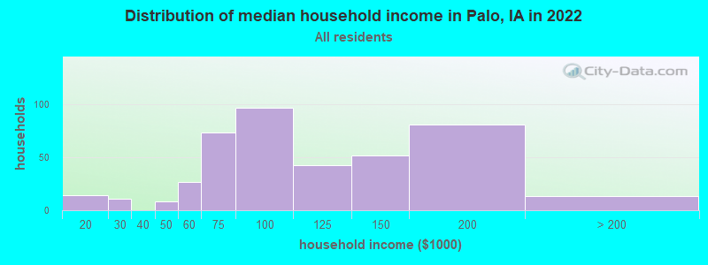
| Palo: | $88,781 |
| IA: | $69,588 |
Estimated per capita income in 2022: $37,796 (it was $21,429 in 2000)
Palo city income, earnings, and wages data
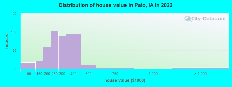
Estimated median house or condo value in 2022: $254,499 (it was $95,300 in 2000)
| Palo: | $254,499 |
| IA: | $194,600 |
Mean prices in 2022: all housing units: $266,093; detached houses: $265,216
Median gross rent in 2022: $1,445.
(5.0% for White Non-Hispanic residents, 5.6% for two or more races residents)
Detailed information about poverty and poor residents in Palo, IA
Compare current foreclosures near Palo, IA:
| Photo | Address | Area | Beds / Baths | Price | Details |
|---|---|---|---|---|---|

|
#1
14th Ave SW
Cedar Rapids, IA 52404
|
844 sq. feet
|
1 baths 2 beds |
$124,900
|
show details |

|
#2
Grande Ave SE
Cedar Rapids, IA 52403
|
2,086 sq. feet
|
3 baths 3 beds |
show details | |

|
#3
24th St NW
Cedar Rapids, IA 52405
|
1,064 sq. feet
|
1 baths 2 beds |
show details | |

|
#4
Park Ave
Center Point, IA 52213
|
1,040 sq. feet
|
1 baths 2 beds |
show details | |

|
#5
C Ave W
Walford, IA 52351
|
1,776 sq. feet
|
3 baths 4 beds |
show details | |

|
#6
Sw7th St
Cedar Rapids, IA 52404
|
1,346 sq. feet
|
1 baths 3 beds |
show details | |

|
#7
W 12th St
Vinton, IA 52349
|
960 sq. feet
|
2 baths 3 beds |
show details | |

|
#8
Grove St NW
Shellsburg, IA 52332
|
1,486 sq. feet
|
1 baths 3 beds |
show details | |

|
#9
Ozark St NE
Cedar Rapids, IA 52402
|
1,233 sq. feet
|
1 baths 3 beds |
show details | |

|
#10
Mallory St SW
Cedar Rapids, IA 52404
|
1,969 sq. feet
|
1 baths 2 beds |
show details |
| Photo | Address | Area | Beds / Baths | Price | Details |
|---|---|---|---|---|---|

|
#11
15th St SE
Cedar Rapids, IA 52403
|
576 sq. feet
|
1 baths 2 beds |
show details | |

|
#12
18th St SE
Cedar Rapids, IA 52403
|
732 sq. feet
|
1 baths 4 beds |
show details | |

|
#13
Bealer Ct SE
Cedar Rapids, IA 52401
|
722 sq. feet
|
1 baths 3 beds |
show details | |

|
#14
5th St SE
Cedar Rapids, IA 52401
|
616 sq. feet
|
1 baths 2 beds |
show details | |

|
#15
Park Ave SE
Cedar Rapids, IA 52403
|
572 sq. feet
|
1 baths 2 beds |
show details | |

|
#16
5th Ave SE
Cedar Rapids, IA 52403
|
728 sq. feet
|
1 baths 3 beds |
show details | |

|
#17
24th Street Dr SE
Cedar Rapids, IA 52403
|
1,076 sq. feet
|
1 baths 2 beds |
show details | |

|
#18
Radcliffe Dr SW
Cedar Rapids, IA 52404
|
1,346 sq. feet
|
2 baths 3 beds |
show details | |

|
#19
King Dr SW
Cedar Rapids, IA 52404
|
1,272 sq. feet
|
3 baths 4 beds |
show details | |

|
#20
10th Ave SE
Cedar Rapids, IA 52401
|
916 sq. feet
|
1 baths 2 beds |
show details |
| Photo | Address | Area | Beds / Baths | Price | Details |
|---|---|---|---|---|---|

|
#21
Main St
Center Point, IA 52213
|
936 sq. feet
|
1 baths 3 beds |
show details | |

|
#22
Commercial St
Central City, IA 52214
|
1,404 sq. feet
|
3 baths 3 beds |
show details | |

|
#23
Lindale Dr
Marion, IA 52302
|
1,607 sq. feet
|
1 baths 3 beds |
show details | |

|
#24
Main St
Center Point, IA 52213
|
1,247 sq. feet
|
2 baths 4 beds |
show details | |

|
#25
Norman Dr NE
Cedar Rapids, IA 52402
|
1,192 sq. feet
|
2 baths 3 beds |
show details | |

|
#26
Oakland Rd NE
Cedar Rapids, IA 52402
|
904 sq. feet
|
1 baths 3 beds |
show details | |

|
#27
B Ave NW
Cedar Rapids, IA 52405
|
572 sq. feet
|
1 baths 3 beds |
show details | |

|
#28
Oakland Rd NE
Cedar Rapids, IA 52402
|
868 sq. feet
|
1 baths 3 beds |
show details | |

|
#29
11th St SW
Cedar Rapids, IA 52404
|
850 sq. feet
|
1 baths 2 beds |
show details | |

|
#30
7th St SW
Cedar Rapids, IA 52404
|
792 sq. feet
|
1 baths 4 beds |
show details |
| Photo | Address | Area | Beds / Baths | Price | Details |
|---|---|---|---|---|---|

|
#31
33rd Ave SW
Cedar Rapids, IA 52404
|
1,324 sq. feet
|
3 baths 3 beds |
show details | |

|
#32
Kelso Ln
Fairfax, IA 52228
|
1,378 sq. feet
|
2 baths 3 beds |
show details | |

|
#33
7th St SW
Cedar Rapids, IA 52404
|
612 sq. feet
|
1 baths 2 beds |
show details | |

|
#34
6th Ave SW
Cedar Rapids, IA 52404
|
616 sq. feet
|
2 baths 3 beds |
show details | |

|
#35
15th Ave SW
Cedar Rapids, IA 52404
|
640 sq. feet
|
1 baths 3 beds |
show details | |

|
#36
Bramble Rd SW
Cedar Rapids, IA 52404
|
894 sq. feet
|
1 baths 4 beds |
show details | |

|
#37
24th St NE
Cedar Rapids, IA 52402
|
832 sq. feet
|
1 baths 2 beds |
show details | |

|
#38
Alpine Rd
Marion, IA 52302
|
923 sq. feet
|
1 baths 3 beds |
show details | |

|
#39
W 9th Ave
Marion, IA 52302
|
1,338 sq. feet
|
1 baths 3 beds |
show details | |

|
#40
Americus Dr SE
Cedar Rapids, IA 52403
|
940 sq. feet
|
1 baths 2 beds |
show details |
| Photo | Address | Area | Beds / Baths | Price | Details |
|---|---|---|---|---|---|

|
#41
Wilson Ave SW
Cedar Rapids, IA 52404
|
672 sq. feet
|
1 baths 2 beds |
show details | |

|
#42
Pleasantview Dr
Marion, IA 52302
|
1,962 sq. feet
|
3 baths 3 beds |
show details | |

|
#43
Grove St
Central City, IA 52214
|
3,121 sq. feet
|
4 baths 3 beds |
show details | |

|
#44
Dows St
Ely, IA 52227
|
1,094 sq. feet
|
1 baths 2 beds |
show details | |

|
#45
River St S
Central City, IA 52214
|
1,959 sq. feet
|
2 baths 3 beds |
show details | |

|
#46
140th St NW
Swisher, IA 52338
|
1,464 sq. feet
|
1 baths 3 beds |
show details | |

|
#47
Rose Ave
Swisher, IA 52338
|
1,912 sq. feet
|
2 baths 4 beds |
show details | |

|
#48
Ridgeview Ct
Cedar Rapids, IA 52403
|
3,268 sq. feet
|
3 baths 5 beds |
show details | |

|
#49
W 3rd St
Vinton, IA 52349
|
2,116 sq. feet
|
6 baths 6 beds |
show details | |

|
Check over 1 million property listings on Foreclosure.com!
|
browse all offers | |||


- 1,07092.2%White alone
- 635.4%Two or more races
- 131.1%Hispanic
- 90.8%Black alone
- 40.3%Asian alone
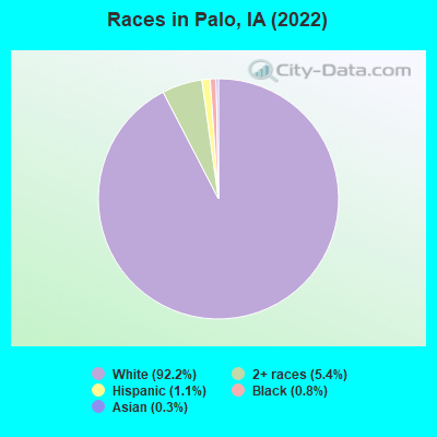
Races in Palo detailed stats: ancestries, foreign born residents, place of birth
According to our research of Iowa and other state lists, there were 3 registered sex offenders living in Palo, Iowa as of May 13, 2024.
The ratio of all residents to sex offenders in Palo is 348 to 1.
 Recent articles from our blog. Our writers, many of them Ph.D. graduates or candidates, create easy-to-read articles on a wide variety of topics.

 | Possible move to Cedar Rapids area for retired couple (20 replies) |
| Iowa Grocery Stores vs. Other States (53 replies) |
| Cheap homes in Cedar Rapids (1 reply) |
| ****Hi there retired, looking at Decorah IA as possible retirement location (27 replies) |
| Escaping CA; going to Cedar Rapids (21 replies) |
| Looking for land in Palo Iowa.... (1 reply) |
Latest news from Palo, IA collected exclusively by city-data.com from local newspapers, TV, and radio stations
Ancestries: German (38.2%), Irish (10.7%), Czech (7.0%), American (4.8%), Italian (2.0%), Polish (1.7%).
Current Local Time: CST time zone
Incorporated on 04/25/1905
Elevation: 746 feet
Land area: 1.25 square miles.
Population density: 1,133 people per square mile (low).

8 residents are foreign born
| This city: | 0.7% |
| Iowa: | 5.6% |
Median real estate property taxes paid for housing units with mortgages in 2022: $3,736 (1.4%)
Median real estate property taxes paid for housing units with no mortgage in 2022: $2,838 (1.3%)
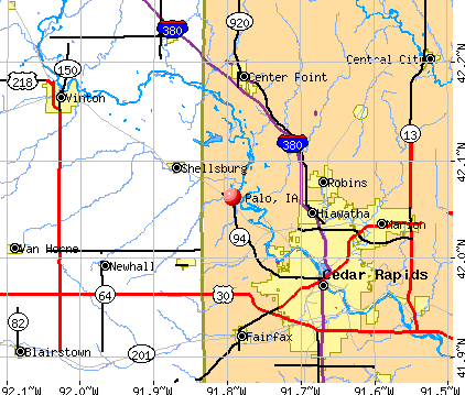
Nearest city with pop. 50,000+: Cedar Rapids, IA  (8.4 miles , pop. 120,758).
Nearest city with pop. 200,000+: Madison, WI (140.8 miles , pop. 208,054).
Nearest city with pop. 1,000,000+: Chicago, IL (212.1 miles , pop. 2,896,016).
Nearest cities:
), )Latitude: 42.06 N, Longitude: 91.79 W
Area code: 319

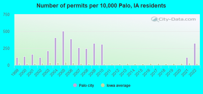
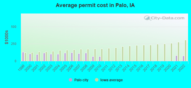
Single-family new house construction building permits:
- 2022: 20 buildings, average cost: $78,400
- 2021: 7 buildings, average cost: $81,300
- 2010: 19 buildings, average cost: $70,400
- 2009: 20 buildings, average cost: $70,400
- 2008: 15 buildings, average cost: $120,000
- 2007: 16 buildings, average cost: $109,300
- 2006: 24 buildings, average cost: $122,800
- 2005: 31 buildings, average cost: $118,900
- 2004: 25 buildings, average cost: $102,200
- 2003: 13 buildings, average cost: $101,900
- 2002: 7 buildings, average cost: $120,900
- 2001: 10 buildings, average cost: $98,700
- 2000: 8 buildings, average cost: $106,200
- 1999: 7 buildings, average cost: $131,500
| Here: | 3.0% |
| Iowa: | 2.7% |
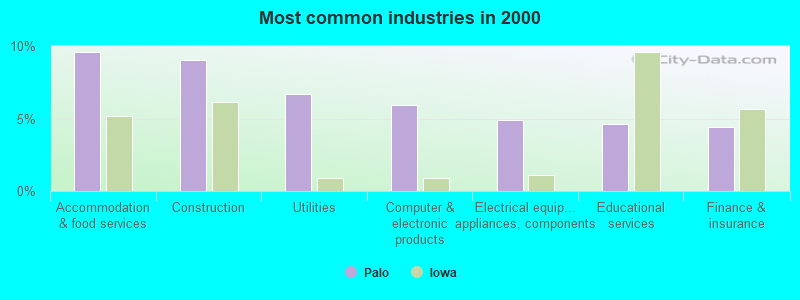
- Accommodation & food services (9.6%)
- Construction (9.0%)
- Utilities (6.7%)
- Computer & electronic products (5.9%)
- Electrical equipment, appliances, components (4.9%)
- Educational services (4.7%)
- Finance & insurance (4.4%)
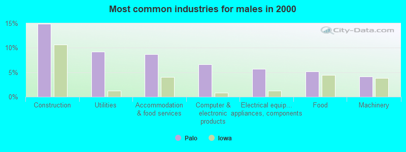
- Construction (14.9%)
- Utilities (9.2%)
- Accommodation & food services (8.7%)
- Computer & electronic products (6.7%)
- Electrical equipment, appliances, components (5.6%)
- Food (5.1%)
- Machinery (4.1%)
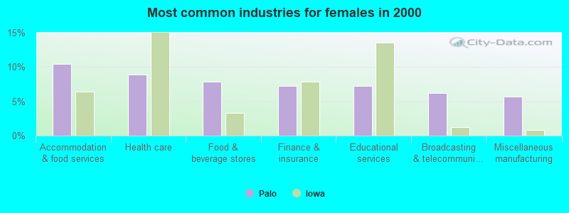
- Accommodation & food services (10.4%)
- Health care (8.9%)
- Food & beverage stores (7.8%)
- Finance & insurance (7.3%)
- Educational services (7.3%)
- Broadcasting & telecommunications (6.2%)
- Miscellaneous manufacturing (5.7%)
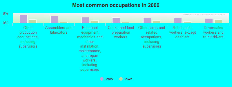
- Other production occupations, including supervisors (6.7%)
- Assemblers and fabricators (5.9%)
- Electrical equipment mechanics and other installation, maintenance, and repair workers, including supervisors (4.9%)
- Cooks and food preparation workers (4.7%)
- Other sales and related occupations, including supervisors (4.4%)
- Retail sales workers, except cashiers (4.1%)
- Driver/sales workers and truck drivers (3.9%)
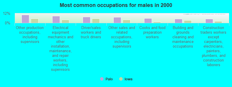
- Other production occupations, including supervisors (10.3%)
- Electrical equipment mechanics and other installation, maintenance, and repair workers, including supervisors (8.7%)
- Driver/sales workers and truck drivers (7.7%)
- Other sales and related occupations, including supervisors (7.2%)
- Cooks and food preparation workers (5.6%)
- Building and grounds cleaning and maintenance occupations (5.1%)
- Construction traders workers except carpenters, electricians, painters, plumbers, and construction laborers (5.1%)
- Assemblers and fabricators (10.9%)
- Other office and administrative support workers, including supervisors (6.8%)
- Retail sales workers, except cashiers (6.2%)
- Cashiers (5.7%)
- Secretaries and administrative assistants (5.7%)
- Child care workers (4.7%)
- Information and record clerks, except customer service representatives (4.7%)
Average climate in Palo, Iowa
Based on data reported by over 4,000 weather stations


(lower is better)
Air Quality Index (AQI) level in 2023 was 103. This is significantly worse than average.
| City: | 103 |
| U.S.: | 73 |
Carbon Monoxide (CO) [ppm] level in 2018 was 0.217. This is about average. Closest monitor was 8.0 miles away from the city center.
| City: | 0.217 |
| U.S.: | 0.251 |
Nitrogen Dioxide (NO2) [ppb] level in 2004 was 3.43. This is significantly better than average. Closest monitor was 7.5 miles away from the city center.
| City: | 3.43 |
| U.S.: | 5.11 |
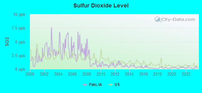
Sulfur Dioxide (SO2) [ppb] level in 2023 was 0.268. This is significantly better than average. Closest monitor was 6.7 miles away from the city center.
| City: | 0.268 |
| U.S.: | 1.515 |
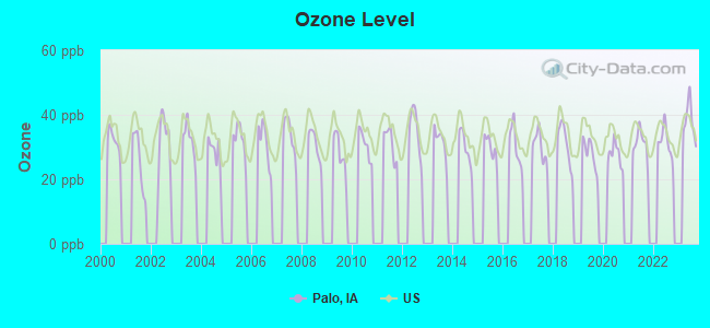
Ozone [ppb] level in 2023 was 38.0. This is about average. Closest monitor was 6.7 miles away from the city center.
| City: | 38.0 |
| U.S.: | 33.3 |
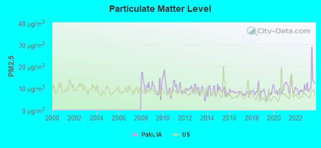
Particulate Matter (PM2.5) [µg/m3] level in 2023 was 13.2. This is significantly worse than average. Closest monitor was 7.1 miles away from the city center.
| City: | 13.2 |
| U.S.: | 8.1 |
Tornado activity:
Palo-area historical tornado activity is near Iowa state average. It is 104% greater than the overall U.S. average.
On 4/30/1954, a category F4 (max. wind speeds 207-260 mph) tornado 3.4 miles away from the Palo city center .
On 8/26/1965, a category F4 tornado 20.4 miles away from the city center killed one person and injured 17 people and caused between $500,000 and $5,000,000 in damages.
Earthquake activity:
Palo-area historical earthquake activity is significantly above Iowa state average. It is 135% greater than the overall U.S. average.On 4/18/2008 at 09:36:59, a magnitude 5.4 (5.1 MB, 4.8 MS, 5.4 MW, 5.2 MW, Class: Moderate, Intensity: VI - VII) earthquake occurred 323.8 miles away from the city center
On 6/10/1987 at 23:48:54, a magnitude 5.1 (4.9 MB, 4.4 MS, 4.6 MS, 5.1 LG) earthquake occurred 304.2 miles away from the city center
On 4/18/2008 at 09:36:59, a magnitude 5.2 (5.2 MW, Depth: 8.9 mi) earthquake occurred 323.8 miles away from Palo center
On 6/28/2004 at 06:10:52, a magnitude 4.2 (4.2 MW, Depth: 6.2 mi, Class: Light, Intensity: IV - V) earthquake occurred 155.0 miles away from Palo center
On 9/3/2016 at 12:02:44, a magnitude 5.8 (5.8 MW, Depth: 3.5 mi) earthquake occurred 477.0 miles away from the city center
On 6/18/2002 at 17:37:15, a magnitude 5.0 (4.3 MB, 4.6 MW, 5.0 LG) earthquake occurred 352.9 miles away from the city center
Magnitude types: regional Lg-wave magnitude (LG), body-wave magnitude (MB), surface-wave magnitude (MS), moment magnitude (MW)
Natural disasters:
The number of natural disasters in Linn County (22) is greater than the US average (15).Major Disasters (Presidential) Declared: 20
Emergencies Declared: 1
Causes of natural disasters: Floods: 17, Storms: 14, Tornadoes: 6, Heavy Rains: 2, Winter Storms: 2, Hurricane: 1, Wind: 1, Other: 1 (Note: some incidents may be assigned to more than one category).

Hospitals and medical centers near Palo:
- HIAWATHA CARE CENTER (Nursing Home, about 6 miles away; HIAWATHA, IA)
- GENTIVA HEALTH SERVICES (Home Health Center, about 6 miles away; HIAWATHA, IA)
- COMFORT CARE MEDICARE INC (Home Health Center, about 6 miles away; CEDAR RAPIDS, IA)
- REM IOWA-TERRY AVENUE (Hospital, about 7 miles away; HIAWATHA, IA)
- WEST RIDGE CARE CENTER (Nursing Home, about 8 miles away; CEDAR RAPIDS, IA)
- NORTHBROOK MANOR CARE CENTER (Nursing Home, about 8 miles away; CEDAR RAPIDS, IA)
- MERCY MEDICAL CENTER DIALYSIS - MERCY PLAZA (Dialysis Facility, about 8 miles away; CEDAR RAPIDS, IA)
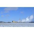
Nuclear power plants:
Duane Arnold . General Electric Co.Bechtel Corp.General Electric Co.IES Utilities, Inc.Boiling Water Reactor (BWR). Net Output: 538 MWe. Operable. Initial criticality: 03/1974. Commercial start: 02/1975..
Colleges/universities with over 2000 students nearest to Palo:
- Kirkwood Community College (about 13 miles; Cedar Rapids, IA; Full-time enrollment: 11,503)
- University of Iowa (about 31 miles; Iowa City, IA; FT enrollment: 24,735)
- Hawkeye Community College (about 38 miles; Waterloo, IA; FT enrollment: 7,160)
- University of Northern Iowa (about 47 miles; Cedar Falls, IA; FT enrollment: 10,816)
- Upper Iowa University (about 54 miles; Fayette, IA; FT enrollment: 5,275)
- Saint Ambrose University (about 73 miles; Davenport, IA; FT enrollment: 3,053)
- Kaplan University-Davenport Campus (about 74 miles; Davenport, IA; FT enrollment: 60,376)
Points of interest:
Notable locations in Palo: Palo City Police Department (A), Palo City Hall (B), Palo Fire Department (C), Benton Linn Ambulance Service (D). Display/hide their locations on the map
Church in Palo: Palo United Methodist Church (A). Display/hide its location on the map
Park in Palo: Zeller Memorial Park (1). Display/hide its location on the map
Birthplace of: Helen Brockman - Centenarian.
Drinking water stations with addresses in Palo and their reported violations in the past:
PLEASANT CREEK ST REC AREA-NORTH (Address: 4530 MCCLINTOCK RD , Population served: 1,000, Groundwater):Past monitoring violations:PLEASANT CREEK ST REC AREA-SOUTH (Address: 4530 MCCLINTOCK RD , Population served: 503, Groundwater):
- One routine major monitoring violation
Past health violations:PONDEROSA HALL AND BALLROOM (Address: 6700 MICHAEL RD , Population served: 100, Groundwater):Past monitoring violations:
- MCL, Monthly (TCR) - In JUN-2011, Contaminant: Coliform. Follow-up actions: St Violation/Reminder Notice (JUN-30-2011), St Public Notif requested (JUL-08-2011), St Formal NOV issued (JUL-08-2011), St Public Notif received (JUL-12-2011), St Compliance achieved (JUL-27-2011)
- One routine major monitoring violation
- One minor monitoring violation
Past health violations:Past monitoring violations:
- MCL, Monthly (TCR) - Between JAN-2013 and MAR-2013, Contaminant: Coliform. Follow-up actions: St Violation/Reminder Notice (MAR-15-2013), St Formal NOV issued (MAR-21-2013), St Public Notif requested (MAR-21-2013), St Public Notif received (APR-08-2013), St Compliance achieved (APR-22-2013)
- MCL, Monthly (TCR) - Between JUL-2008 and SEP-2008, Contaminant: Coliform. Follow-up actions: St Public Notif requested (JUL-24-2008), St Formal NOV issued (JUL-24-2008), St Public Notif received (SEP-05-2008), St Compliance achieved (JAN-02-2009)
- MCL, Monthly (TCR) - Between APR-2008 and JUN-2008, Contaminant: Coliform. Follow-up actions: St Violation/Reminder Notice (JUN-02-2008), St Public Notif requested (JUN-12-2008), St Formal NOV issued (JUN-12-2008), St Public Notif received (SEP-05-2008), St Compliance achieved (JAN-02-2009)
- One regular monitoring violation
| This city: | 2.9 people |
| Iowa: | 2.4 people |
| This city: | 81.6% |
| Whole state: | 64.7% |
| This city: | 7.0% |
| Whole state: | 6.7% |
Likely homosexual households (counted as self-reported same-sex unmarried-partner households)
- Lesbian couples: 0.3% of all households
- Gay men: 0.0% of all households
Banks with branches in Palo (2011 data):
- Palo Savings Bank: at 606 First Street, branch established on 1908/01/01. Info updated 2006/11/03: Bank assets: $31.1 mil, Deposits: $26.7 mil, local headquarters, positive income, Agricultural Specialization, 1 total offices, Holding Company: Bankers Equity Corporation
For population 15 years and over in Palo:
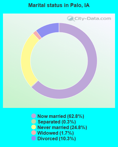
- Never married: 24.8%
- Now married: 62.8%
- Separated: 0.3%
- Widowed: 1.7%
- Divorced: 10.3%
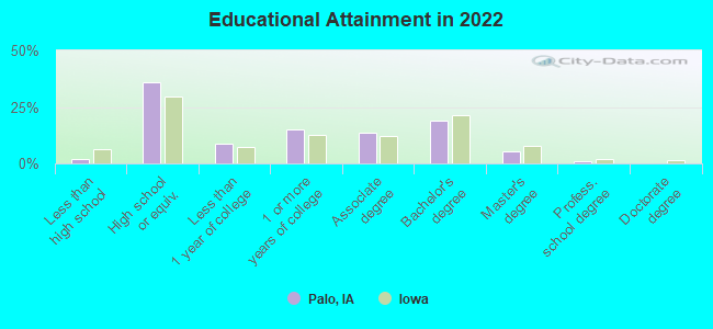
For population 25 years and over in Palo:
- High school or higher: 97.8%
- Bachelor's degree or higher: 23.6%
- Graduate or professional degree: 6.4%
- Unemployed: 1.8%
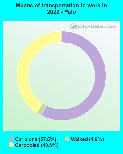
- Mean travel time to work (commute): 22.8 minutes
| Here: | 7.7 |
| Iowa average: | 10.5 |
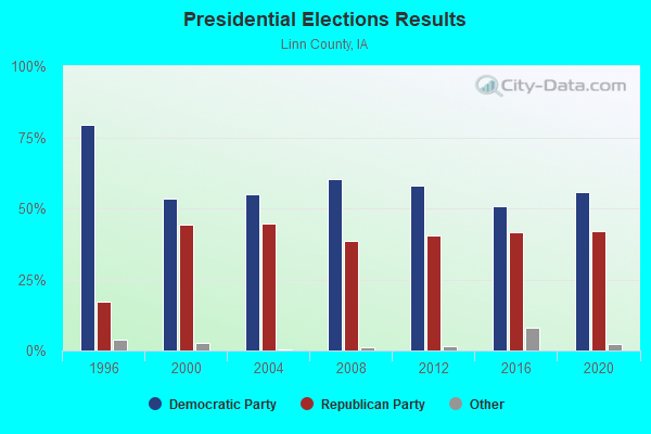
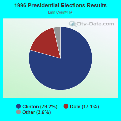
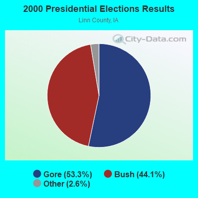

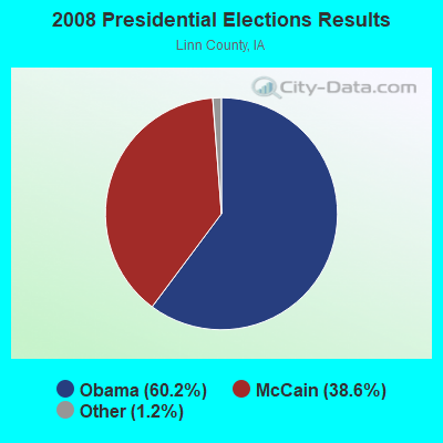


Graphs represent county-level data. Detailed 2008 Election Results
Religion statistics for Palo, IA (based on Linn County data)
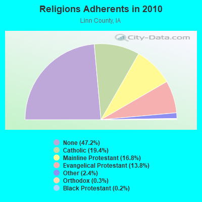
| Religion | Adherents | Congregations |
|---|---|---|
| Catholic | 40,930 | 18 |
| Mainline Protestant | 35,522 | 75 |
| Evangelical Protestant | 29,184 | 88 |
| Other | 4,969 | 18 |
| Orthodox | 545 | 2 |
| Black Protestant | 433 | 2 |
| None | 99,643 | - |
Food Environment Statistics:
| Here: | 1.31 / 10,000 pop. |
| Iowa: | 2.14 / 10,000 pop. |
| This county: | 0.24 / 10,000 pop. |
| Iowa: | 0.23 / 10,000 pop. |
| Linn County: | 0.15 / 10,000 pop. |
| Iowa: | 0.43 / 10,000 pop. |
| Here: | 4.28 / 10,000 pop. |
| Iowa: | 5.55 / 10,000 pop. |
| Linn County: | 7.10 / 10,000 pop. |
| Iowa: | 8.01 / 10,000 pop. |
| Linn County: | 7.2% |
| Iowa: | 7.8% |
| Linn County: | 28.6% |
| Iowa: | 27.3% |
| This county: | 13.4% |
| Iowa: | 14.5% |
Health and Nutrition:
| This city: | 58.2% |
| Iowa: | 49.5% |
| Palo: | 59.0% |
| Iowa: | 46.1% |
| Here: | 27.6 |
| Iowa: | 28.6 |
| This city: | 14.5% |
| Iowa: | 21.4% |
| This city: | 6.8 |
| Iowa: | 6.8 |
| Palo: | 28.9% |
| State: | 33.8% |
| Palo: | 65.1% |
| Iowa: | 55.9% |
| Palo: | 80.3% |
| Iowa: | 77.7% |
More about Health and Nutrition of Palo, IA Residents
| Local government employment and payroll (March 2022) | |||||
| Function | Full-time employees | Monthly full-time payroll | Average yearly full-time wage | Part-time employees | Monthly part-time payroll |
|---|---|---|---|---|---|
| Sewerage | 2 | $7,870 | $47,220 | 0 | $0 |
| Other Government Administration | 2 | $8,963 | $53,778 | 2 | $712 |
| Water Supply | 1 | $5,919 | $71,028 | 1 | $620 |
| Parks and Recreation | 0 | $0 | 1 | $202 | |
| Totals for Government | 5 | $22,752 | $54,605 | 4 | $1,533 |
Palo government finances - Expenditure in 2017 (per resident):
- Construction - Regular Highways: $109,000 ($76.81)
General - Other: $86,000 ($60.61)
- Current Operations - Sewerage: $446,000 ($314.31)
General - Other: $369,000 ($260.04)
Financial Administration: $160,000 ($112.76)
Water Utilities: $155,000 ($109.23)
Parks and Recreation: $150,000 ($105.71)
Regular Highways: $91,000 ($64.13)
Solid Waste Management: $64,000 ($45.10)
Police Protection: $36,000 ($25.37)
Local Fire Protection: $26,000 ($18.32)
General Public Buildings: $15,000 ($10.57)
Judicial and Legal Services: $13,000 ($9.16)
Central Staff Services: $5,000 ($3.52)
Health - Other: $1,000 ($0.70)
- General - Interest on Debt: $141,000 ($99.37)
- Intergovernmental to Local - Other - Sewerage: $173,000 ($121.92)
Other - Police Protection: $36,000 ($25.37)
- Total Salaries and Wages: $210,000 ($147.99)
Palo government finances - Revenue in 2017 (per resident):
- Charges - Sewerage: $386,000 ($272.02)
Solid Waste Management: $77,000 ($54.26)
- Federal Intergovernmental - Other: $124,000 ($87.39)
- Miscellaneous - Rents: $23,000 ($16.21)
General Revenue - Other: $13,000 ($9.16)
Fines and Forfeits: $1,000 ($0.70)
Interest Earnings: $1,000 ($0.70)
Sale of Property: $1,000 ($0.70)
- Revenue - Water Utilities: $206,000 ($145.17)
- State Intergovernmental - Highways: $127,000 ($89.50)
General Local Government Support: $21,000 ($14.80)
Other: $6,000 ($4.23)
- Tax - Property: $626,000 ($441.16)
General Sales and Gross Receipts: $141,000 ($99.37)
Public Utilities Sales: $7,000 ($4.93)
Other License: $5,000 ($3.52)
Palo government finances - Debt in 2017 (per resident):
- Long Term Debt - Beginning Outstanding - Unspecified Public Purpose: $5,715,000 ($4027.48)
Outstanding Unspecified Public Purpose: $4,905,000 ($3456.66)
Retired Unspecified Public Purpose: $810,000 ($570.82)
Palo government finances - Cash and Securities in 2017 (per resident):
- Bond Funds - Cash and Securities: $340,000 ($239.61)
- Other Funds - Cash and Securities: $829,000 ($584.21)
Strongest AM radio stations in Palo:
- WMT (600 AM; 5 kW; CEDAR RAPIDS, IA; Owner: CITICASTERS LICENSES, L.P.)
- KXEL (1540 AM; 50 kW; WATERLOO, IA; Owner: KXEL BROADCASTING COMPANY, INC.)
- KMRY (1450 AM; 1 kW; CEDAR RAPIDS, IA; Owner: SELLERS BROADCASTING, INC.)
- KCRG (1600 AM; 5 kW; CEDAR RAPIDS, IA; Owner: CEDAR RAPIDS TELEVISION CO.)
- WHO (1040 AM; 50 kW; DES MOINES, IA; Owner: CITICASTERS LICENSES, L.P.)
- KCJJ (1630 AM; 10 kW; IOWA CITY, IA; Owner: RIVER CITY RADIO, INC.)
- KMJM (1360 AM; 1 kW; CEDAR RAPIDS, IA; Owner: CAPSTAR TX LIMITED PARTNERSHIP)
- KDNZ (1650 AM; 10 kW; CEDAR FALLS, IA; Owner: FIFE COMMUNICATIONS CO., LLC)
- KCNZ (1250 AM; 10 kW; CEDAR FALLS, IA; Owner: FIFE COMMUNICATION COMPANY, L.C.)
- WSUI (910 AM; 5 kW; IOWA CITY, IA; Owner: THE UNIVERSITY OF IOWA)
- KKHQ (950 AM; 5 kW; OELWEIN, IA; Owner: CUMULUS LICENSING CORP.)
- KWLO (1330 AM; 5 kW; WATERLOO, IA; Owner: KXEL BROADCASTING COMPANY, INC.)
- WTMJ (620 AM; 50 kW; MILWAUKEE, WI; Owner: JOURNAL BROADCAST CORPORATION)
Strongest FM radio stations in Palo:
- KDAT (104.5 FM; CEDAR RAPIDS, IA; Owner: CUMULUS LICENSING CORP.)
- KZIA (102.9 FM; CEDAR RAPIDS, IA; Owner: KZIA, INC.)
- KUNI (90.9 FM; CEDAR FALLS, IA; Owner: UNIVERSITY OF NORTHERN IOWA)
- WMT-FM (96.5 FM; CEDAR RAPIDS, IA; Owner: CITICASTERS LICENSES, L.P.)
- KFMW (107.9 FM; WATERLOO, IA; Owner: KXEL BROADCASTING COMPANY, INC.)
- KRNA (94.1 FM; IOWA CITY, IA; Owner: CUMULUS LICENSING CORP.)
- KOKZ (105.7 FM; WATERLOO, IA; Owner: KXEL BROADCASTING COMPANY, INC.)
- KHAK (98.1 FM; CEDAR RAPIDS, IA; Owner: CUMULUS LICENSING CORP.)
- KCCK-FM (88.3 FM; CEDAR RAPIDS, IA; Owner: KIRKWOOD COMMUNITY COLLEGE)
- KOEL-FM (92.3 FM; OELWEIN, IA; Owner: CUMULUS LICENSING CORP.)
- KNWS-FM (101.9 FM; WATERLOO, IA; Owner: NORTHWESTERN COLLEGE)
- KSUI (91.7 FM; IOWA CITY, IA; Owner: THE UNIVERSITY OF IOWA)
- K261CA (100.1 FM; CEDAR RAPIDS, IA; Owner: POWER DU PREE BROADCASTING COMPANY)
- KKRQ (100.7 FM; IOWA CITY, IA; Owner: CITICASTERS LICENSES, L.P.)
TV broadcast stations around Palo:
- KFXA (Channel 28; CEDAR RAPIDS, IA; Owner: SECOND GENERATION OF IOWA, LTD.)
- KGAN (Channel 2; CEDAR RAPIDS, IA; Owner: KGAN LICENSEE, LLC)
- KCRG-TV (Channel 9; CEDAR RAPIDS, IA; Owner: CEDAR RAPIDS TELEVISION CO.)
- KRIN (Channel 32; WATERLOO, IA; Owner: IOWA PUBLIC BROADCASTING BOARD)
- KWWL (Channel 7; WATERLOO, IA; Owner: RAYCOM AMERICA, INC.)
- K17ET (Channel 17; CEDAR RAPIDS, IA; Owner: TRINITY BROADCASTING NETWORK)
- KPXR (Channel 48; CEDAR RAPIDS, IA; Owner: PAXSON COMMUNICATIONS LICENSE COMPANY, LLC)
- KWKB (Channel 20; IOWA CITY, IA; Owner: KM TELEVISION OF IOWA, L.L.C.)
- KIIN (Channel 12; IOWA CITY, IA; Owner: IOWA PUBLIC BROADCASTING BOARD)
- KCDE-LP (Channel 67; CEDAR RAPIDS, IA; Owner: TIGER EYE BROADCASTING CORPORATION)
- KCDR-LP (Channel 55; CEDAR RAPIDS, IA; Owner: TIGER EYE BROADCASTING CORPORATION)
- KHHH-LP (Channel 57; CEDAR RAPIDS, IA; Owner: TIGER EYE BROADCASTING CORPORATION)
- KRUB-LP (Channel 65; CEDAR RAPIDS, IA; Owner: TIGER EYE BROADCASTING CORPORATION)
Palo fatal accident list:
Sep 7, 2007 00:02 AM, Sr-94, Lat: 42.047978, Lon: -91.789550, Vehicles: 1, Persons: 4, Fatalities: 1, Drunk persons involved: 1
Dec 18, 1997 00:59 AM, 4765, Vehicles: 1, Persons: 1, Fatalities: 1, Drunk persons involved: 1
- National Bridge Inventory (NBI) Statistics
- 14Number of bridges
- 207ft / 63.0mTotal length
- 12,210Total average daily traffic
- 1,315Total average daily truck traffic
- 12,210Total future (year 2039) average daily traffic
- New bridges - historical statistics
- 11940-1949
- 21950-1959
- 11970-1979
- 51980-1989
- 21990-1999
- 32000-2009
FCC Registered Cell Phone Towers:
1 (See the full list of FCC Registered Cell Phone Towers in Palo)FCC Registered Antenna Towers:
14 (See the full list of FCC Registered Antenna Towers)FCC Registered Broadcast Land Mobile Towers:
7- 3277 Daec Rd (Lat: 42.100556 Lon: -91.776833), Call Sign: KFA423,
Assigned Frequencies: 154.280 MHz, 154.430 MHz, Grant Date: 10/01/2011, Expiration Date: 12/17/2021, Cancellation Date: 02/19/2022, Registrant: Linn County Sheriff\'s Office, Cedar Rapids, IA 52404, Phone: (319) 892-6100, Email:
- Daec Nuclear Power Plant 2.5 Mi Ne (Lat: 42.100556 Lon: -91.776833), Call Sign: KVJ952,
Assigned Frequencies: 155.370 MHz, Grant Date: 01/15/2013, Expiration Date: 03/17/2023, Cancellation Date: 12/19/2022, Registrant: Iowa State Patrol Communications, 5912 Nw 2nd St, Des Moines, IA 50313, Phone: (515) 281-3175, Fax: (515) 281-6761, Email:
- Daec Nuclear Plant 2.5 Mi Ne (Lat: 42.100556 Lon: -91.777111), Call Sign: KNHN943,
Assigned Frequencies: 153.545 MHz, Grant Date: 12/11/2013, Expiration Date: 10/20/2023, Cancellation Date: 10/11/2023, Certifier: Robert E Helfrich, Registrant: Florida Power & Light Company, 6445 Nw 72nd Ave, Miami, FL 33166, Phone: (305) 903-2160, Email:
- Lat: 42.101056 Lon: -91.777833, Call Sign: WSI360,
Assigned Frequencies: 461.100 MHz, 466.100 MHz, Grant Date: 04/14/2021, Expiration Date: 03/27/2031, Certifier: Robert Helfrich, Registrant: Florida Power & Light Co., 6445 Nw 72nd Ave, Miami, FL 33166, Phone: (305) 903-2160, Email:
- FPL-DAEC, 3277 Daec Rd. (Lat: 42.103056 Lon: -91.781389), Type: Tower, Structure height: 103.6 m, Overall height: 106.7 m, Call Sign: WQPG882,
Assigned Frequencies: 451.750 MHz, Grant Date: 05/19/2022, Expiration Date: 05/15/2032, Certifier: Scott Hansen, Registrant: Benton County Ema, 2131 North Towne Lane Ne, Cedar Rapids, IA 52402, Phone: (319) 393-7150, Fax: (319) 393-9273, Email:
- Lat: 42.098194 Lon: -91.783278, Call Sign: WQYG750,
Assigned Frequencies: 10250.0 MHz, Grant Date: 09/22/2016, Expiration Date: 09/22/2026, Certifier: Ronald Hinsley, Registrant: Itc Midwest, 27175 Energy Way, Novi, MI 48377, Phone: (248) 946-3046, Fax: (248) 946-3638, Email:
- Lat: 42.100917 Lon: -91.777361, Call Sign: WRCI510,
Assigned Frequencies: 451.925 MHz, 456.925 MHz, 461.350 MHz, 466.350 MHz, 462.375 MHz, 467.375 MHz, Grant Date: 10/10/2018, Expiration Date: 10/10/2028, Certifier: Brian Moran, Registrant: Electronic Engineering Co, 1100 Keo Way, Des Moines, IA 50309, Phone: (515) 283-1100, Fax: (515) 244-6948, Email:
FCC Registered Microwave Towers:
3- 8137600020119026, Lat: 42.114056 Lon: -91.807222, Type: Mast, Structure height: 5 m, Call Sign: WQJA665,
Assigned Frequencies: 3650.00 MHz, Grant Date: 09/13/2018, Expiration Date: 02/14/2021, Cancellation Date: 03/09/2021, Registrant: Rise Broadband, 61 Inverness Drive East Suite 250, Englewood, CO 80211, Phone: (402) 739-8482, Email:
- DAEC, 3277 Daec Rd.,2.5 Mi. North And 1 Mi. East Of (Lat: 42.103056 Lon: -91.781389), Type: Gtower, Structure height: 103.6 m, Overall height: 106.7 m, Call Sign: WQQX652,
Assigned Frequencies: 6375.14 MHz, 6345.49 MHz, Grant Date: 03/15/2023, Expiration Date: 03/20/2033, Certifier: Charlie Mcclintock, Registrant: Linn County Radio Governance Board, 713 1st Ave Se, Cedar Rapids, IA 52401, Phone: (319) 286-5200, Fax: (319) 286-5250, Email:
- DAEC, 3277 Daec Rd.,2.5 Mi. North And 1 Mi. East Of (Lat: 42.102917 Lon: -91.781361), Type: Tower, Structure height: 103.6 m, Overall height: 106.7 m, Call Sign: WLQ68,
Assigned Frequencies: 5945.20 MHz, 6004.50 MHz, Grant Date: 07/19/2018, Expiration Date: 08/19/2028, Registrant: Interstate Power And Light Company, 1031 Iowa Street, Suite 769, Dubuque, IA 52001, Phone: (563) 584-7474, Fax: (563) 557-2259, Email:
FCC Registered Amateur Radio Licenses:
23 (See the full list of FCC Registered Amateur Radio Licenses in Palo)| Home Mortgage Disclosure Act Aggregated Statistics For Year 2009 (Based on 1 partial tract) | ||||||
| A) FHA, FSA/RHS & VA Home Purchase Loans | B) Conventional Home Purchase Loans | C) Refinancings | ||||
|---|---|---|---|---|---|---|
| Number | Average Value | Number | Average Value | Number | Average Value | |
| LOANS ORIGINATED | 1 | $91,480 | 1 | $222,800 | 5 | $168,072 |
| APPLICATIONS APPROVED, NOT ACCEPTED | 0 | $0 | 0 | $0 | 0 | $0 |
| APPLICATIONS DENIED | 0 | $0 | 0 | $0 | 1 | $107,950 |
| APPLICATIONS WITHDRAWN | 0 | $0 | 0 | $0 | 1 | $132,330 |
| FILES CLOSED FOR INCOMPLETENESS | 0 | $0 | 0 | $0 | 0 | $0 |
Detailed HMDA statistics for the following Tracts: 0106.00
| Private Mortgage Insurance Companies Aggregated Statistics For Year 2003 (Based on 1 partial tract) | ||
| B) Refinancings | ||
|---|---|---|
| Number | Average Value | |
| LOANS ORIGINATED | 1 | $86,540 |
| APPLICATIONS APPROVED, NOT ACCEPTED | 0 | $0 |
| APPLICATIONS DENIED | 0 | $0 |
| APPLICATIONS WITHDRAWN | 0 | $0 |
| FILES CLOSED FOR INCOMPLETENESS | 0 | $0 |
Detailed PMIC statistics for the following Tracts: 0106.00
2002 - 2018 National Fire Incident Reporting System (NFIRS) incidents
- Fire incident types reported to NFIRS in Palo, IA
- 8352.2%Outside Fires
- 4930.8%Structure Fires
- 2113.2%Mobile Property/Vehicle Fires
- 63.8%Other
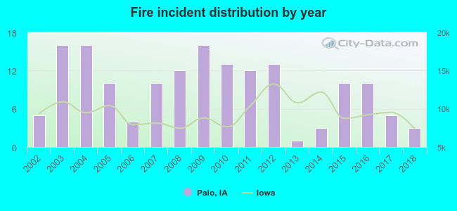 Based on the data from the years 2002 - 2018 the average number of fire incidents per year is 9. The highest number of reported fires - 16 took place in 2003, and the least - 1 in 2013. The data has a dropping trend.
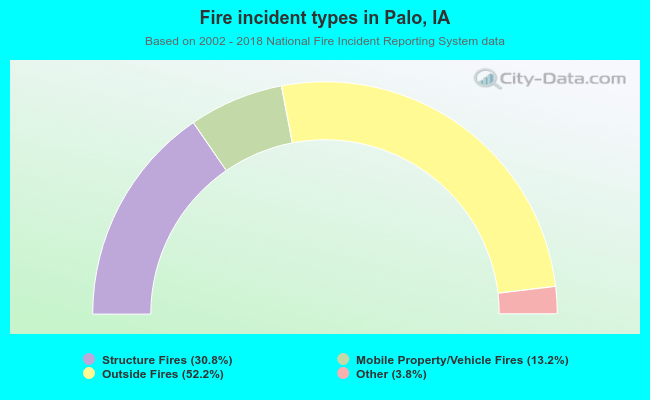 When looking into fire subcategories, the most reports belonged to: Outside Fires (52.2%), and Structure Fires (30.8%).
| Most common first names in Palo, IA among deceased individuals | ||
| Name | Count | Lived (average) |
|---|---|---|
| Robert | 10 | 67.3 years |
| William | 9 | 83.8 years |
| John | 9 | 79.4 years |
| Mary | 8 | 84.0 years |
| George | 7 | 81.0 years |
| James | 6 | 73.5 years |
| Charles | 5 | 72.8 years |
| Roy | 4 | 79.2 years |
| Harry | 4 | 72.7 years |
| Donald | 4 | 66.7 years |
| Most common last names in Palo, IA among deceased individuals | ||
| Last name | Count | Lived (average) |
|---|---|---|
| Owens | 11 | 81.6 years |
| Young | 6 | 81.2 years |
| Barker | 5 | 65.8 years |
| Yates | 5 | 87.4 years |
| Reynolds | 5 | 83.6 years |
| Rawson | 5 | 77.0 years |
| Hayes | 5 | 74.2 years |
| Railsback | 5 | 83.2 years |
| Miller | 4 | 81.7 years |
| Melton | 4 | 77.5 years |

- 81.3%Utility gas
- 16.9%Electricity
- 1.8%Bottled, tank, or LP gas
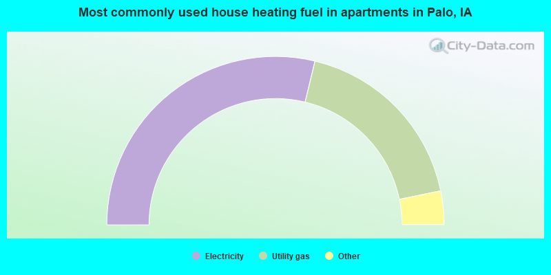
- 61.5%Electricity
- 38.5%Utility gas
Palo compared to Iowa state average:
- Unemployed percentage significantly below state average.
- Black race population percentage below state average.
- Hispanic race population percentage significantly below state average.
- Median age significantly below state average.
- Foreign-born population percentage significantly below state average.
- Renting percentage significantly below state average.
- Length of stay since moving in significantly below state average.
- House age significantly below state average.
- Number of college students below state average.

|
|
Total of 12 patent applications in 2008-2024.