Pearl, Kentucky
Submit your own pictures of this place and show them to the world
- OSM Map
- General Map
- Google Map
- MSN Map

| Males: 169 | |
| Females: 174 |
| Median resident age: | 34.8 years |
| Kentucky median age: | 35.9 years |
Zip code: 40940
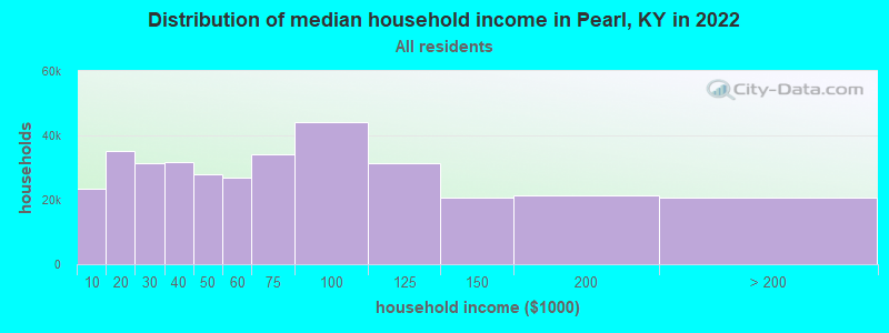
| Pearl: | $25,578 |
| KY: | $59,341 |
Estimated per capita income in 2022: $12,353 (it was $6,978 in 2000)
Pearl CCD income, earnings, and wages data
Estimated median house or condo value in 2022: $57,364 (it was $22,400 in 2000)
| Pearl: | $57,364 |
| KY: | $196,300 |
Mean prices in 2022: all housing units: $141,900; detached houses: $157,411; townhouses or other attached units: $178,646; mobile homes: $82,371
Detailed information about poverty and poor residents in Pearl, KY
Compare current foreclosures near Pearl, KY:
| Photo | Address | Area | Beds / Baths | Price | Details |
|---|---|---|---|---|---|

|
#1
Browns Creek Rd
Williamsburg, KY 40769
|
1,200 sq. feet
|
1 baths 3 beds |
$75,000
|
show details |

|
#2
Big Brush Church Creek Rd
Trosper, KY 40995
|
- sq. feet
|
- baths - beds |
$11,900
|
show details |

|
#3
Wooldridge Ln
Jellico, TN 37762
|
1,322 sq. feet
|
1 baths 3 beds |
show details | |

|
#4
Kay Jay Camp Rd
Barbourville, KY 40906
|
700 sq. feet
|
1 baths 2 beds |
show details | |

|
#5
Cowan Ln
La Follette, TN 37766
|
1,350 sq. feet
|
2 baths 3 beds |
show details | |

|
#6
N 16th St
Middlesboro, KY 40965
|
672 sq. feet
|
1 baths 2 beds |
show details | |

|
#7
Main St
Williamsburg, KY 40769
|
988 sq. feet
|
1 baths 3 beds |
show details | |

|
#8
John St
Williamsburg, KY 40769
|
1,713 sq. feet
|
1 baths 3 beds |
show details | |

|
#9
Red Fox Rd
Williamsburg, KY 40769
|
1,972 sq. feet
|
1 baths 3 beds |
show details | |

|
#10
Chapman Crest Dr
La Follette, TN 37766
|
1,379 sq. feet
|
1 baths - beds |
show details |
| Photo | Address | Area | Beds / Baths | Price | Details |
|---|---|---|---|---|---|

|
#11
N 28th St
Middlesboro, KY 40965
|
1,113 sq. feet
|
1 baths - beds |
show details | |

|
#12
Kimberly Rd
La Follette, TN 37766
|
960 sq. feet
|
1 baths - beds |
show details | |

|
#13
Valley Ln
Speedwell, TN 37870
|
1,792 sq. feet
|
2 baths - beds |
show details | |

|
#14
Alex Smith Ln
La Follette, TN 37766
|
1,792 sq. feet
|
1 baths - beds |
show details | |

|
#15
Providence Rd
Cumberland Gap, TN 37724
|
1,000 sq. feet
|
1 baths - beds |
show details | |

|
#16
Toppy Russell Rd
Speedwell, TN 37870
|
1,404 sq. feet
|
1 baths - beds |
show details | |

|
#17
Back Valley Rd
Speedwell, TN 37870
|
1,008 sq. feet
|
1 baths - beds |
show details | |

|
#18
Summit Dr
Speedwell, TN 37870
|
2,552 sq. feet
|
2 baths - beds |
show details | |

|
#19
Morton Rd
La Follette, TN 37766
|
1,118 sq. feet
|
1 baths - beds |
show details | |

|
#20
Magnolia Ln
La Follette, TN 37766
|
1,174 sq. feet
|
1 baths - beds |
show details |
| Photo | Address | Area | Beds / Baths | Price | Details |
|---|---|---|---|---|---|

|
#21
Hickory Hill Cir
Duff, TN 37729
|
1,120 sq. feet
|
1 baths - beds |
show details | |

|
#22
Imperial Heights Ln
La Follette, TN 37766
|
728 sq. feet
|
1 baths - beds |
show details | |

|
#23
Sled Creek Rd
Duff, TN 37729
|
1,105 sq. feet
|
1 baths - beds |
show details | |

|
#24
White Oak Rd
Duff, TN 37729
|
1,302 sq. feet
|
1 baths - beds |
show details | |

|
#25
Lick Creek Ln
La Follette, TN 37766
|
1,444 sq. feet
|
1 baths - beds |
show details | |

|
#26
Brantley Acres Rd
Speedwell, TN 37870
|
1,836 sq. feet
|
2 baths - beds |
show details | |

|
#27
Boulevard Of Champions Rd
Williamsburg, KY 40769
|
- sq. feet
|
- baths - beds |
show details | |

|
#28
Davis Chapel Rd
La Follette, TN 37766
|
- sq. feet
|
- baths - beds |
show details | |

|
#29
State Ln
La Follette, TN 37766
|
- sq. feet
|
- baths - beds |
show details | |

|
#30
Redbird Rd
Williamsburg, KY 40769
|
- sq. feet
|
- baths - beds |
show details |
| Photo | Address | Area | Beds / Baths | Price | Details |
|---|---|---|---|---|---|

|
#31
Bull Run Rd
Barbourville, KY 40906
|
- sq. feet
|
- baths - beds |
show details | |

|
#32
N 2nd St
Williamsburg, KY 40769
|
- sq. feet
|
- baths - beds |
show details | |

|
#33
E Highway 904
Williamsburg, KY 40769
|
- sq. feet
|
- baths - beds |
show details | |

|
#34
Davis Chapel Rd
La Follette, TN 37766
|
- sq. feet
|
- baths - beds |
show details | |

|
#35
Lindenberg Dr
Williamsburg, KY 40769
|
- sq. feet
|
- baths - beds |
show details | |

|
#36
Lindenberg Dr
Williamsburg, KY 40769
|
- sq. feet
|
- baths - beds |
show details | |

|
#37
Sandy Hill Rd
La Follette, TN 37766
|
- sq. feet
|
- baths - beds |
show details | |

|
#38
Mcgaffie Loop
Pineville, KY 40977
|
- sq. feet
|
- baths - beds |
show details | |

|
#39
Big Sinks Rd
Sharps Chapel, TN 37866
|
- sq. feet
|
- baths - beds |
show details | |

|
#40
Little Elk Creek Rd
Pioneer, TN 37847
|
- sq. feet
|
- baths - beds |
show details |
| Photo | Address | Area | Beds / Baths | Price | Details |
|---|---|---|---|---|---|

|
#41
Eastgate Dr Apt 208
La Follette, TN 37766
|
- sq. feet
|
- baths - beds |
show details | |

|
#42
Old Pineville Pike
Middlesboro, KY 40965
|
- sq. feet
|
- baths - beds |
show details | |

|
#43
Lowood Ln
Newcomb, TN 37819
|
- sq. feet
|
- baths - beds |
show details | |

|
#44
Pruden Rd
Clairfield, TN 37715
|
- sq. feet
|
- baths - beds |
show details | |

|
#45
Rock Creek Ridge Rd
Clairfield, TN 37715
|
- sq. feet
|
- baths - beds |
show details | |

|
#46
Hickory Hill Cir
Duff, TN 37729
|
1,960 sq. feet
|
- baths - beds |
show details | |

|
#47
Ken Taylor Rd
Williamsburg, KY 40769
|
- sq. feet
|
- baths - beds |
show details | |

|
#48
Sukey Hollow Rd
Williamsburg, KY 40769
|
- sq. feet
|
- baths - beds |
show details | |

|
#49
Shelton Rd
Williamsburg, KY 40769
|
- sq. feet
|
- baths - beds |
show details | |

|
Check over 1 million property listings on Foreclosure.com!
|
browse all offers | |||

- 31898.5%White alone
- 41.2%Hispanic
- 10.3%Two or more races

Races in Pearl detailed stats: ancestries, foreign born residents, place of birth
 Recent articles from our blog. Our writers, many of them Ph.D. graduates or candidates, create easy-to-read articles on a wide variety of topics.
Current Local Time: EST time zone
Land area: 13.8 square miles.
Population density: 25 people per square mile (very low).

| Pearl CCD: | 0.9% ($199) |
| Kentucky: | 0.8% ($610) |
Nearest city with pop. 50,000+: Knoxville, TN  (43.8 miles , pop. 173,890).
Nearest city with pop. 200,000+: Fayette, KY (102.8 miles , pop. 260,512).
Nearest city with pop. 1,000,000+: Chicago, IL (413.3 miles , pop. 2,896,016).
Nearest cities:
), ), ), ), ), )Latitude: 36.61 N, Longitude: 83.96 W
Area code commonly used in this area: 423

| Here: | 4.4% |
| Kentucky: | 3.8% |
Average climate in Pearl, Kentucky
Based on data reported by over 4,000 weather stations


(lower is better)

Air Quality Index (AQI) level in 2023 was 80.8. This is about average.
| City: | 80.8 |
| U.S.: | 72.6 |

Carbon Monoxide (CO) [ppm] level in 2000 was 0.127. This is significantly better than average. Closest monitor was 12.3 miles away from the city center.
| City: | 0.127 |
| U.S.: | 0.251 |

Ozone [ppb] level in 2023 was 31.3. This is about average. Closest monitor was 11.9 miles away from the city center.
| City: | 31.3 |
| U.S.: | 33.3 |

Particulate Matter (PM2.5) [µg/m3] level in 2022 was 9.68. This is about average. Closest monitor was 12.3 miles away from the city center.
| City: | 9.68 |
| U.S.: | 8.11 |
Tornado activity:
Pearl-area historical tornado activity is below Kentucky state average. It is 29% smaller than the overall U.S. average.
On 3/12/1967, a category F3 (max. wind speeds 158-206 mph) tornado 10.0 miles away from the Pearl place center .
On 4/3/1974, a category F4 (max. wind speeds 207-260 mph) tornado 33.2 miles away from the place center .
Earthquake activity:
Pearl-area historical earthquake activity is significantly above Kentucky state average. It is 74% greater than the overall U.S. average.On 7/27/1980 at 18:52:21, a magnitude 5.2 (5.1 MB, 4.7 MS, 5.0 UK, 5.2 UK, Class: Moderate, Intensity: VI - VII) earthquake occurred 110.6 miles away from the city center
On 11/30/1973 at 07:48:41, a magnitude 4.7 (4.7 MB, 4.6 ML, Class: Light, Intensity: IV - V) earthquake occurred 55.8 miles away from the city center
On 8/9/2020 at 12:07:37, a magnitude 5.1 (5.1 MW, Depth: 4.7 mi) earthquake occurred 159.5 miles away from Pearl center
On 4/18/2008 at 09:36:59, a magnitude 5.4 (5.1 MB, 4.8 MS, 5.4 MW, 5.2 MW) earthquake occurred 250.4 miles away from the city center
On 9/7/1988 at 02:28:09, a magnitude 4.6 (4.5 MB, 4.6 LG) earthquake occurred 106.4 miles away from the city center
On 8/23/2011 at 17:51:04, a magnitude 5.8 (5.8 MW, Depth: 3.7 mi) earthquake occurred 343.5 miles away from Pearl center
Magnitude types: regional Lg-wave magnitude (LG), body-wave magnitude (MB), local magnitude (ML), surface-wave magnitude (MS), moment magnitude (MW)
Natural disasters:
The number of natural disasters in Whitley County (24) is greater than the US average (15).Major Disasters (Presidential) Declared: 17
Emergencies Declared: 2
Causes of natural disasters: Floods: 14, Storms: 13, Mudslides: 6, Tornadoes: 6, Landslides: 5, Winter Storms: 4, Fires: 2, Winds: 2, Blizzard: 1, Freeze: 1, Hurricane: 1, Snow: 1, Snowfall: 1, Snowstorm: 1, Other: 1 (Note: some incidents may be assigned to more than one category).
Hospitals and medical centers near Pearl:
- BEECH TREE MANOR (Nursing Home, about 10 miles away; JELLICO, TN)
- JELLICO COMMUNITY HOSPITAL Acute Care Hospitals (about 10 miles away; JELLICO, TN)
- SUNBELT HOMECARE (Home Health Center, about 10 miles away; JELLICO, TN)
- MIDDLESBORO HEALTH CARE FACILITY (Nursing Home, about 12 miles away; MIDDLESBORO, KY)
- MIDDLESBORO APPALACHIAN REGIONAL HEALTHCARE HOSPIT Acute Care Hospitals (about 13 miles away; MIDDLESBORO, KY)
- MIDDLESBORO ARH HOME HEALTH AGENCY (Home Health Center, about 14 miles away; MIDDLESBORO, KY)
- AMEDISYS HOME HEALTH CARE (Home Health Center, about 14 miles away; MIDDLESBORO, KY)
Colleges/universities with over 2000 students nearest to Pearl:
- University of the Cumberlands (about 15 miles; Williamsburg, KY; Full-time enrollment: 3,585)
- Lincoln Memorial University (about 17 miles; Harrogate, TN; FT enrollment: 3,706)
- The University of Tennessee-Knoxville (about 46 miles; Knoxville, TN; FT enrollment: 25,483)
- Pellissippi State Community College (about 47 miles; Knoxville, TN; FT enrollment: 7,271)
- Walters State Community College (about 48 miles; Morristown, TN; FT enrollment: 4,359)
- Somerset Community College (about 49 miles; Somerset, KY; FT enrollment: 4,698)
- Southeast Kentucky Community and Technical College (about 60 miles; Cumberland, KY; FT enrollment: 2,196)
Points of interest:
Church in Pearl: Lower Laurel Fork Church (A). Display/hide its location on the map
Cemetery: King Cemetery (1). Display/hide its location on the map
Streams, rivers, and creeks: Tiny Branch (A). Display/hide its location on the map
| This place: | 2.5 people |
| Kentucky: | 2.5 people |
| This place: | 76.1% |
| Whole state: | 66.9% |
| This place: | 3.7% |
| Whole state: | 6.4% |
No gay or lesbian households reported
| This place: | 45.8% |
| Whole state: | 15.8% |
| This place: | 5.2% |
| Whole state: | 6.6% |
For population 15 years and over in Pearl:

- Never married: 25.3%
- Now married: 49.1%
- Separated: 0.0%
- Widowed: 18.9%
- Divorced: 6.8%
For population 25 years and over in Pearl:
- High school or higher: 48.6%
- Bachelor's degree or higher: 0.0%
- Graduate or professional degree: 0.0%
- Mean travel time to work (commute): 43.9 minutes


| Here: | 16.5 |
| Kentucky average: | 13.8 |

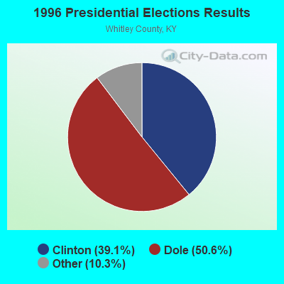
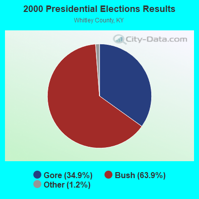
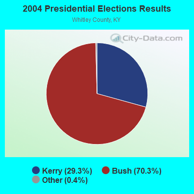
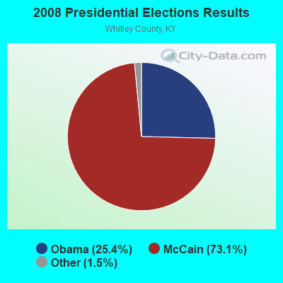
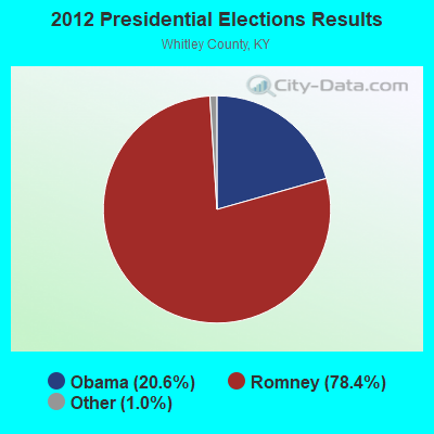
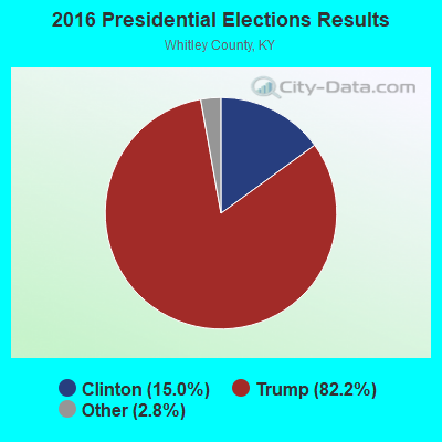
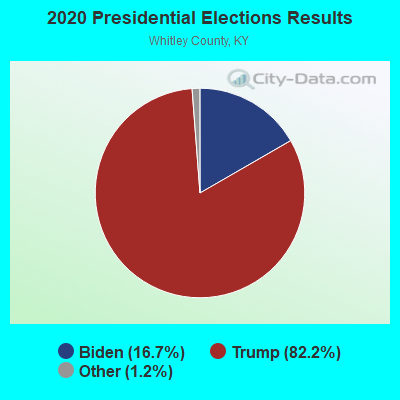
Graphs represent county-level data. Detailed 2008 Election Results
Religion statistics for Pearl, KY (based on Whitley County data)
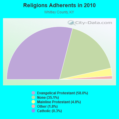
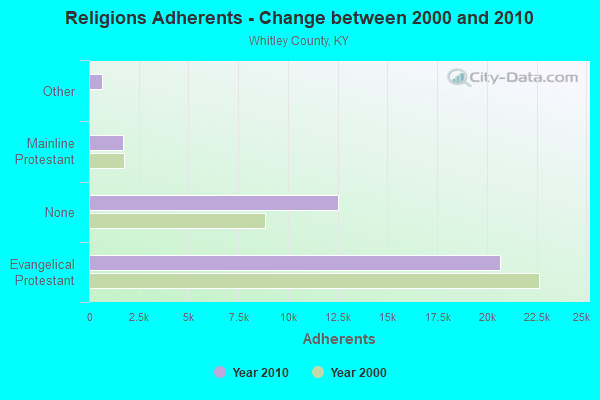
| Religion | Adherents | Congregations |
|---|---|---|
| Evangelical Protestant | 20,685 | 78 |
| Mainline Protestant | 1,697 | 7 |
| Other | 652 | 3 |
| Catholic | 92 | 2 |
| None | 12,511 | - |
Food Environment Statistics:
| Here: | 2.35 / 10,000 pop. |
| State: | 2.19 / 10,000 pop. |
| This county: | 0.26 / 10,000 pop. |
| Kentucky: | 0.25 / 10,000 pop. |
| This county: | 1.04 / 10,000 pop. |
| Kentucky: | 0.74 / 10,000 pop. |
| This county: | 5.22 / 10,000 pop. |
| State: | 4.36 / 10,000 pop. |
| Whitley County: | 3.39 / 10,000 pop. |
| State: | 5.74 / 10,000 pop. |
| Whitley County: | 13.9% |
| Kentucky: | 11.0% |
| Whitley County: | 30.9% |
| Kentucky: | 30.0% |
| Here: | 20.7% |
| State: | 15.9% |
Strongest AM radio stations in Pearl:
- WKVL (850 AM; daytime; 50 kW; KNOXVILLE, TN; Owner: HORNE RADIO, LLC)
- WMIK (560 AM; 2 kW; MIDDLESBORO, KY; Owner: GATEWAY BROADCASTING, INC.)
- WEKC (710 AM; daytime; 4 kW; WILLIAMSBURG, KY; Owner: GERALD PARKS)
- WEZJ (1440 AM; 2 kW; WILLIAMSBURG, KY; Owner: WHITLEY BROADCASTING CO., INC.)
- WKDP (1330 AM; 5 kW; CORBIN, KY; Owner: EUBANKS BROADCASTING, INC.)
- WNOX (990 AM; 10 kW; KNOXVILLE, TN)
- WQBB (1040 AM; daytime; 10 kW; POWELL, TN; Owner: JOURNAL BROADCAST CORPORATION)
- WJJT (1540 AM; 1 kW; JELLICO, TN; Owner: DOUGLAS BROADCASTING CORPORATION)
- WRWB (740 AM; 1 kW; HARROGATE, TN; Owner: PINE HILLS OF TENNESSEE, INC.)
- WVLZ (1180 AM; daytime; 10 kW; KNOXVILLE, TN; Owner: KIRKLAND WIRELESS BROADCASTERS, INC.)
- WRJZ (620 AM; 5 kW; KNOXVILLE, TN; Owner: TENNESSEE MEDIA ASSOCIATES, INC)
- WFGW (1010 AM; 50 kW; BLACK MOUNTAIN, NC; Owner: BLUE RIDGE BROADCASTING CORP.)
- WYWY (950 AM; 1 kW; BARBOURVILLE, KY; Owner: BARBOURVILLE-COMMNITY BROADC/G CO IN)
Strongest FM radio stations in Pearl:
- WMIK-FM (92.7 FM; MIDDLESBORO, KY; Owner: GATEWAY BROADCASTING, INC.)
- WEKX (102.7 FM; JELLICO, TN; Owner: WHITLEY BROADCASTING CO., INC.)
- WDVX (89.9 FM; CLINTON, TN; Owner: CUMBERLAND COMMUNITIES COMMUNI CORP.)
- WRIL (106.3 FM; PINEVILLE, KY; Owner: PINE HILLS BROADCASTING, INC.)
- WCTU (105.9 FM; TAZEWELL, TN; Owner: STAIR COMPANY, INC)
- WEZJ-FM (104.3 FM; WILLIAMSBURG, KY; Owner: WHITLEY BROADCASTING CO., INC.)
- WIMZ-FM (103.5 FM; KNOXVILLE, TN; Owner: SOUTH CENTRAL COMM., CORP.)
- WOKI-FM (100.3 FM; OAK RIDGE, TN; Owner: OAK RIDGE FM, INC.)
- WUOT (91.9 FM; KNOXVILLE, TN; Owner: UNIVERSITY OF TENNESSEE)
- WKDP-FM (99.5 FM; CORBIN, KY; Owner: EUBANKS BROADCASTING, INC.)
- WQLA-FM (104.9 FM; LA FOLLETTE, TN; Owner: LAFOLLETTE BROADCASTERS, INC.)
- WIVK-FM (107.7 FM; KNOXVILLE, TN; Owner: CITADEL BROADCASTING COMPANY)
- WJXB-FM (97.5 FM; KNOXVILLE, TN; Owner: SOUTH CENTRAL COMMUNICATIONS CORP.)
- WWST (102.1 FM; SEVIERVILLE, TN; Owner: JOURNAL BROADCAST CORPORATION)
- WCTT-FM (107.3 FM; CORBIN, KY; Owner: ENCORE COMMUNICATIONS, INC.)
- WSEH (102.7 FM; CUMBERLAND, KY; Owner: CUMBERLAND CITY BROADCASTING, INC.)
- WJDT (106.5 FM; ROGERSVILLE, TN; Owner: C & S BROADCASTING)
- WBGQ (100.7 FM; BULLS GAP, TN; Owner: CHEROKEE BROADCASTING)
- WTUK (105.1 FM; HARLAN, KY; Owner: EASTERN BROADCASTING COMPANY)
- WRMX-FM (106.7 FM; NORRIS, TN; Owner: SOUTH CENTRAL COMMUNICATIONS CORPORATION)
TV broadcast stations around Pearl:
- WKOP-TV (Channel 15; KNOXVILLE, TN; Owner: EAST TENNESSEE PUBLIC COMMUNICATIONS CORP.)
- WVLT-TV (Channel 8; KNOXVILLE, TN; Owner: WVLT LICENSEE CORP.)
- WBIR-TV (Channel 10; KNOXVILLE, TN; Owner: GANNETT PACIFIC CORPORATION)
- WATE-TV (Channel 6; KNOXVILLE, TN; Owner: WATE, G.P.)
- WTNZ (Channel 43; KNOXVILLE, TN; Owner: RAYCOM AMERICA, INC.)
- WEEE-LP (Channel 32; KNOXVILLE, TN; Owner: TIGER EYE BROADCASTING CORPORATION)
- WPXK (Channel 54; JELLICO, TN; Owner: PAXSON KNOXVILLE LICENSE, INC.)
- WEZK-LP (Channel 28; KNOXVILLE, TN; Owner: SOUTH CENTRAL COMMUNICATIONS CORP.)

- 56.6%Electricity
- 27.4%Coal or coke
- 9.4%Fuel oil, kerosene, etc.
- 6.6%Bottled, tank, or LP gas

- 63.3%Bottled, tank, or LP gas
- 36.7%Fuel oil, kerosene, etc.
Pearl compared to Kentucky state average:
- Median household income significantly below state average.
- Median house value significantly below state average.
- Unemployed percentage significantly below state average.
- Black race population percentage significantly below state average.
- Hispanic race population percentage significantly below state average.
- Median age below state average.
- Foreign-born population percentage significantly below state average.
- Renting percentage significantly below state average.
- Length of stay since moving in significantly above state average.
- Number of rooms per house significantly below state average.
- House age significantly below state average.
- Number of college students significantly below state average.
- Percentage of population with a bachelor's degree or higher significantly below state average.