Plympton, Massachusetts
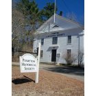
Plympton: The Ol' Town Hall...

Plympton: Hillcrest Cemetery...
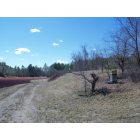
Plympton: Every bog needs a bee-hive.
- add
your
Submit your own pictures of this town and show them to the world
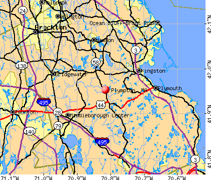
- OSM Map
- General Map
- Google Map
- MSN Map
Population change since 2000: +6.9%
 |
| Males: 1,384 | |
| Females: 1,436 |
| Median resident age: | 44.4 years |
| Massachusetts median age: | 39.2 years |
Zip codes: 02367.
| Plympton: | $129,943 |
| MA: | $94,488 |
Estimated per capita income in 2022: $53,191 (it was $24,344 in 2000)
Plympton town income, earnings, and wages data
Estimated median house or condo value in 2022: $656,481 (it was $210,800 in 2000)
| Plympton: | $656,481 |
| MA: | $534,700 |
Mean prices in 2022: all housing units: $585,203; detached houses: $620,100; townhouses or other attached units: $487,972; in 2-unit structures: $464,355; in 3-to-4-unit structures: $429,583; in 5-or-more-unit structures: $438,441; mobile homes: $207,706; occupied boats, rvs, vans, etc.: $17,153
Detailed information about poverty and poor residents in Plympton, MA


- 2,70896.0%White alone
- 361.3%Hispanic
- 240.9%Two or more races
- 230.8%Black alone
- 220.8%Asian alone
- 50.2%Other race alone
- 20.07%American Indian alone
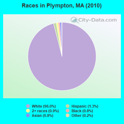
Races in Plympton detailed stats: ancestries, foreign born residents, place of birth
According to our research of Massachusetts and other state lists, there were 2 registered sex offenders living in Plympton, Massachusetts as of May 19, 2024.
The ratio of all residents to sex offenders in Plympton is 1,410 to 1.
The ratio of registered sex offenders to all residents in this city is near the state average.
Type |
2009 |
2010 |
2011 |
2012 |
2013 |
2014 |
2015 |
2016 |
2017 |
2018 |
2019 |
2020 |
2021 |
2022 |
|---|---|---|---|---|---|---|---|---|---|---|---|---|---|---|
| Murders (per 100,000) | 0 (0.0) | 0 (0.0) | 0 (0.0) | 0 (0.0) | 0 (0.0) | 0 (0.0) | 0 (0.0) | 0 (0.0) | 0 (0.0) | 0 (0.0) | 0 (0.0) | 0 (0.0) | 0 (0.0) | 0 (0.0) |
| Rapes (per 100,000) | 0 (0.0) | 0 (0.0) | 0 (0.0) | 0 (0.0) | 1 (35.1) | 0 (0.0) | 0 (0.0) | 0 (0.0) | 1 (33.6) | 0 (0.0) | 0 (0.0) | 2 (64.4) | 0 (0.0) | 0 (0.0) |
| Robberies (per 100,000) | 0 (0.0) | 0 (0.0) | 1 (35.2) | 0 (0.0) | 1 (35.1) | 1 (34.8) | 0 (0.0) | 1 (34.2) | 0 (0.0) | 1 (33.5) | 1 (33.6) | 0 (0.0) | 0 (0.0) | 0 (0.0) |
| Assaults (per 100,000) | 9 (320.1) | 4 (141.8) | 6 (211.5) | 2 (69.9) | 5 (175.3) | 4 (139.1) | 0 (0.0) | 0 (0.0) | 3 (100.8) | 4 (133.9) | 3 (100.7) | 3 (96.6) | 2 (63.4) | 3 (97.6) |
| Burglaries (per 100,000) | 6 (213.4) | 11 (390.1) | 12 (423.0) | 34 (1,188) | 17 (596.1) | 16 (556.5) | 3 (104.0) | 4 (136.9) | 6 (201.6) | 6 (200.8) | 5 (167.8) | 6 (193.2) | 2 (63.4) | 0 (0.0) |
| Thefts (per 100,000) | 21 (746.8) | 21 (744.7) | 22 (775.5) | 38 (1,328) | 24 (841.5) | 14 (487.0) | 14 (485.3) | 6 (205.3) | 9 (302.4) | 19 (635.9) | 10 (335.6) | 24 (772.9) | 18 (570.2) | 6 (195.1) |
| Auto thefts (per 100,000) | 2 (71.1) | 5 (177.3) | 2 (70.5) | 1 (34.9) | 1 (35.1) | 1 (34.8) | 0 (0.0) | 1 (34.2) | 1 (33.6) | 1 (33.5) | 1 (33.6) | 1 (32.2) | 1 (31.7) | 4 (130.1) |
| Arson (per 100,000) | 0 (0.0) | 1 (35.5) | 0 (0.0) | 2 (69.9) | 0 (0.0) | 1 (34.8) | 1 (34.7) | 0 (0.0) | 0 (0.0) | 0 (0.0) | 0 (0.0) | 0 (0.0) | 1 (31.7) | 0 (0.0) |
| City-Data.com crime index | 114.5 | 99.6 | 119.1 | 153.0 | 151.8 | 99.5 | 26.7 | 30.8 | 75.9 | 79.0 | 58.1 | 117.9 | 42.4 | 37.7 |
The City-Data.com crime index weighs serious crimes and violent crimes more heavily. Higher means more crime, U.S. average is 246.1. It adjusts for the number of visitors and daily workers commuting into cities.
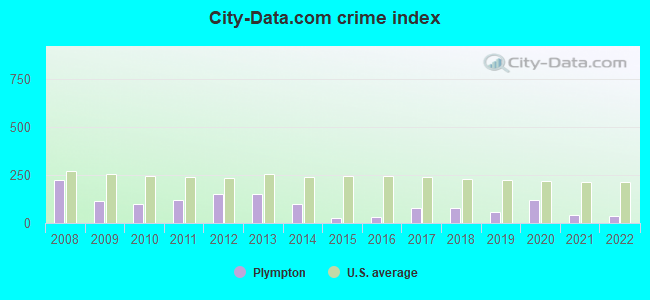
Crime rate in Plympton detailed stats: murders, rapes, robberies, assaults, burglaries, thefts, arson
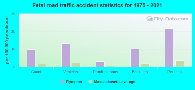
Full-time law enforcement employees in 2021, including police officers: 9 (8 officers - 8 male; 0 female).
| Officers per 1,000 residents here: | 2.53 |
| Massachusetts average: | 2.53 |
 Recent articles from our blog. Our writers, many of them Ph.D. graduates or candidates, create easy-to-read articles on a wide variety of topics.

 | People are leaving Massachusetts in droves. Who are they? (334 replies) |
| 2023 Real Estate Observations (5278 replies) |
| Home Prices By Town for 2022 (190 replies) |
| 2021 Real Estate Observations (1729 replies) |
| Oklahoma to (likely Western) Massachusetts - Beginning Research (274 replies) |
| Moderate towns with 95 (50 replies) |
Latest news from Plympton, MA collected exclusively by city-data.com from local newspapers, TV, and radio stations
Ancestries: Irish (28.7%), English (23.7%), Italian (16.6%), French (9.8%), German (8.8%), Scottish (4.8%).
Current Local Time: EST time zone
Incorporated in 1707
Elevation: 105 feet
Land area: 14.8 square miles.
Population density: 191 people per square mile (very low).
54 residents are foreign born (1.0% Europe, 0.8% North America, 0.3% Africa).
| This town: | 2.0% |
| Massachusetts: | 12.2% |
| Plympton town: | 1.3% ($2,799) |
| Massachusetts: | 1.3% ($2,336) |
Nearest city with pop. 50,000+: Brockton, MA  (13.6 miles , pop. 94,304).
Nearest city with pop. 200,000+: Boston, MA (28.4 miles , pop. 589,141).
Nearest city with pop. 1,000,000+: Bronx, NY (177.1 miles , pop. 1,332,650).
Nearest cities:
), ), Latitude: 41.97 N, Longitude: 70.80 W

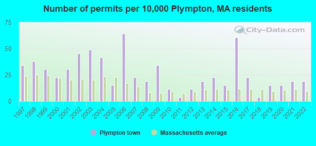
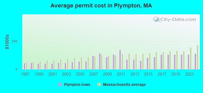
Single-family new house construction building permits:
- 2022: 5 buildings, average cost: $284,300
- 2021: 5 buildings, average cost: $263,100
- 2020: 4 buildings, average cost: $265,300
- 2019: 4 buildings, average cost: $264,200
- 2018: 1 building, cost: $266,000
- 2017: 6 buildings, average cost: $264,800
- 2016: 16 buildings, average cost: $218,500
- 2015: 4 buildings, average cost: $212,400
- 2014: 6 buildings, average cost: $156,600
- 2013: 5 buildings, average cost: $176,800
- 2012: 3 buildings, average cost: $175,000
- 2011: 1 building, cost: $350,000
- 2010: 3 buildings, average cost: $263,300
- 2009: 9 buildings, average cost: $219,400
- 2008: 5 buildings, average cost: $287,000
- 2007: 6 buildings, average cost: $242,000
- 2006: 17 buildings, average cost: $143,100
- 2005: 4 buildings, average cost: $142,600
- 2004: 11 buildings, average cost: $131,000
- 2003: 13 buildings, average cost: $118,100
- 2002: 12 buildings, average cost: $120,600
- 2001: 8 buildings, average cost: $104,600
- 2000: 6 buildings, average cost: $105,100
- 1999: 8 buildings, average cost: $102,900
- 1998: 10 buildings, average cost: $116,500
- 1997: 9 buildings, average cost: $112,400
| Here: | 3.2% |
| Massachusetts: | 3.5% |
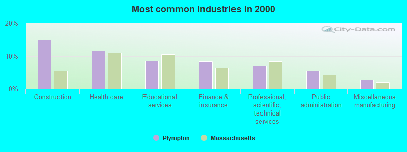
- Construction (15.0%)
- Health care (11.7%)
- Educational services (8.5%)
- Finance & insurance (8.3%)
- Professional, scientific, technical services (6.9%)
- Public administration (5.4%)
- Miscellaneous manufacturing (2.8%)
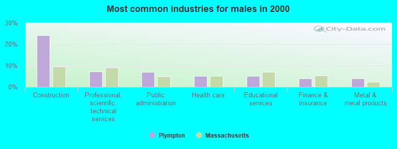
- Construction (24.1%)
- Professional, scientific, technical services (7.3%)
- Public administration (7.1%)
- Health care (5.2%)
- Educational services (5.2%)
- Finance & insurance (4.0%)
- Metal & metal products (3.9%)
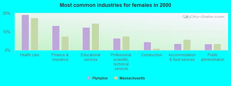
- Health care (19.2%)
- Finance & insurance (13.3%)
- Educational services (12.4%)
- Professional, scientific, technical services (6.4%)
- Construction (4.5%)
- Accommodation & food services (3.5%)
- Public administration (3.4%)
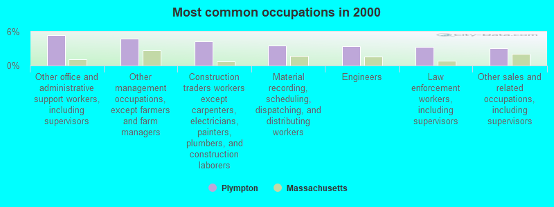
- Other office and administrative support workers, including supervisors (5.4%)
- Other management occupations, except farmers and farm managers (4.7%)
- Construction traders workers except carpenters, electricians, painters, plumbers, and construction laborers (4.3%)
- Material recording, scheduling, dispatching, and distributing workers (3.5%)
- Engineers (3.5%)
- Law enforcement workers, including supervisors (3.3%)
- Other sales and related occupations, including supervisors (3.1%)
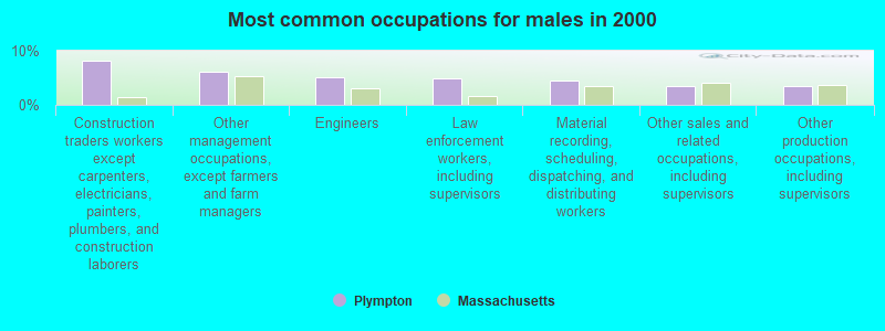
- Construction traders workers except carpenters, electricians, painters, plumbers, and construction laborers (8.1%)
- Other management occupations, except farmers and farm managers (6.2%)
- Engineers (5.0%)
- Law enforcement workers, including supervisors (4.9%)
- Material recording, scheduling, dispatching, and distributing workers (4.5%)
- Other sales and related occupations, including supervisors (3.5%)
- Other production occupations, including supervisors (3.5%)

- Other office and administrative support workers, including supervisors (9.8%)
- Registered nurses (6.0%)
- Secretaries and administrative assistants (5.1%)
- Customer service representatives (5.0%)
- Financial clerks, except bookkeeping, accounting and auditing clerks (3.8%)
- Supervisors and other personal care and service workers, except child care workers (3.8%)
- Preschool, kindergarten, elementary, and middle school teachers (3.7%)
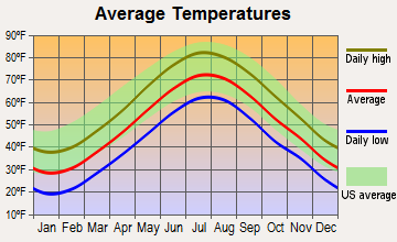
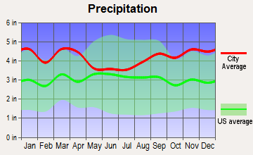
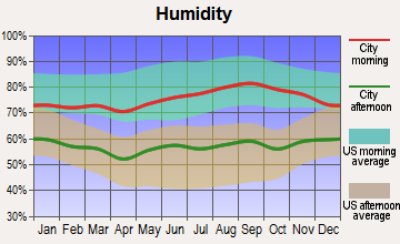
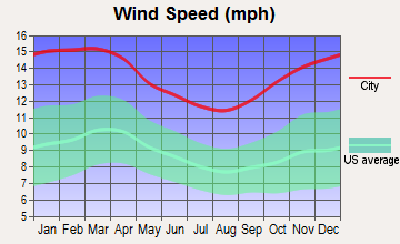
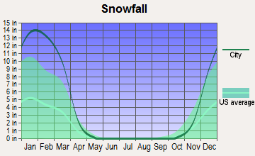
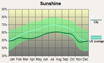
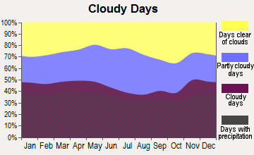
Average climate in Plympton, Massachusetts
Based on data reported by over 4,000 weather stations
(lower is better)
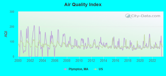
Air Quality Index (AQI) level in 2022 was 64.9. This is about average.
| City: | 64.9 |
| U.S.: | 72.6 |
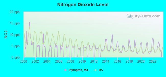
Nitrogen Dioxide (NO2) [ppb] level in 2022 was 4.28. This is about average. Closest monitor was 7.3 miles away from the city center.
| City: | 4.28 |
| U.S.: | 5.11 |
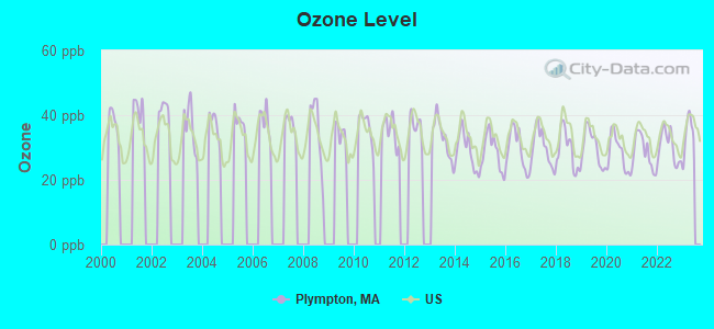
Ozone [ppb] level in 2022 was 30.2. This is about average. Closest monitor was 12.6 miles away from the city center.
| City: | 30.2 |
| U.S.: | 33.3 |
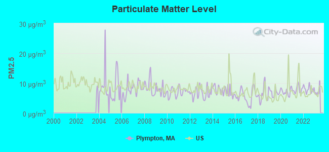
Particulate Matter (PM2.5) [µg/m3] level in 2022 was 7.99. This is about average. Closest monitor was 12.6 miles away from the city center.
| City: | 7.99 |
| U.S.: | 8.11 |
Tornado activity:
Plympton-area historical tornado activity is below Massachusetts state average. It is 65% smaller than the overall U.S. average.
On 6/9/1953, a category F3 (max. wind speeds 158-206 mph) tornado 21.1 miles away from the Plympton town center injured 17 people and caused between $500,000 and $5,000,000 in damages.
On 6/9/1953, a category F4 (max. wind speeds 207-260 mph) tornado 43.3 miles away from the town center killed 90 people and injured 1228 people and caused between $50,000,000 and $500,000,000 in damages.
Earthquake activity:
Plympton-area historical earthquake activity is significantly above Massachusetts state average. It is 75% smaller than the overall U.S. average.On 10/7/1983 at 10:18:46, a magnitude 5.3 (5.1 MB, 5.3 LG, 5.1 ML, Class: Moderate, Intensity: VI - VII) earthquake occurred 225.6 miles away from the city center
On 4/20/2002 at 10:50:47, a magnitude 5.3 (5.3 ML, Depth: 3.0 mi) earthquake occurred 228.4 miles away from the city center
On 10/16/2012 at 23:12:25, a magnitude 4.7 (4.7 ML, Depth: 10.0 mi, Class: Light, Intensity: IV - V) earthquake occurred 112.9 miles away from Plympton center
On 1/19/1982 at 00:14:42, a magnitude 4.7 (4.5 MB, 4.7 MD, 4.5 LG) earthquake occurred 113.3 miles away from the city center
On 4/20/2002 at 10:50:47, a magnitude 5.2 (5.2 MB, 4.2 MS, 5.2 MW, 5.0 MW) earthquake occurred 227.8 miles away from the city center
On 8/22/1992 at 12:20:32, a magnitude 4.8 (4.8 MB, 3.8 MS, 4.7 LG, Depth: 6.2 mi) earthquake occurred 199.7 miles away from the city center
Magnitude types: regional Lg-wave magnitude (LG), body-wave magnitude (MB), duration magnitude (MD), local magnitude (ML), surface-wave magnitude (MS), moment magnitude (MW)
Natural disasters:
The number of natural disasters in Plymouth County (26) is a lot greater than the US average (15).Major Disasters (Presidential) Declared: 17
Emergencies Declared: 9
Causes of natural disasters: Floods: 11, Storms: 9, Hurricanes: 7, Snows: 3, Snowstorms: 3, Blizzards: 2, Winter Storms: 2, Heavy Rain: 1, Snowfall: 1, Tropical Storm: 1, Wind: 1 (Note: some incidents may be assigned to more than one category).
Hospitals and medical centers near Plympton:
- WINGATE AT SILVER LAKE REHAB AND SKILLED NURSING RES (Nursing Home, about 4 miles away; KINGSTON, MA)
- BAY PATH AT DUXBURY NURSING AND REHABILITATION CTR (Nursing Home, about 6 miles away; DUXBURY, MA)
- FRESENIUS MEDICAL CARE OF PLYMOUTH CORDAGE (Dialysis Facility, about 6 miles away; PLYMOUTH, MA)
- CRANBERRY HOSPICE (Hospital, about 6 miles away; PLYMOUTH, MA)
- CENTRUS PREMIER HOME CARE (Home Health Center, about 7 miles away; PLYMOUTH, MA)
- BAY COLONY VISITING NURSE ASSOCIATIOM (Home Health Center, about 7 miles away; PEMBROKE, MA)
- CARE HOME AND HEALTHCARE SERVICES INC (Home Health Center, about 7 miles away; PLYMOUTH, MA)
Operable nuclear power plant near Plympton:
- 8 miles: Pilgrim in Plymouth, MA.
Colleges/universities with over 2000 students nearest to Plympton:
- Bridgewater State University (about 9 miles; Bridgewater, MA; Full-time enrollment: 9,802)
- Massasoit Community College (about 13 miles; Brockton, MA; FT enrollment: 5,442)
- Stonehill College (about 16 miles; Easton, MA; FT enrollment: 2,563)
- Quincy College (about 23 miles; Quincy, MA; FT enrollment: 3,184)
- Bristol Community College (about 24 miles; Fall River, MA; FT enrollment: 5,707)
- Curry College (about 25 miles; Milton, MA; FT enrollment: 2,586)
- University of Massachusetts-Dartmouth (about 26 miles; North Dartmouth, MA; FT enrollment: 7,545)
Public elementary/middle school in Plympton:
- DENNETT ELEMENTARY (Students: 236, Location: 80 CRESCENT STREET, Grades: KG-6)
Points of interest:
Notable locations in Plympton: Exodus Medical Transportation (A), Plympton Fire Department (B), Dennett Elementary School Library (C), Deborah Sampson House Museum (D), Plympton Historical Society Building (E), Plympton Public Library (F), Plympton Town Hall (G). Display/hide their locations on the map
Churches in Plympton include: Silver Lake Chapel (A), Plympton Congregational Church (B), New Covenant Fellowship Church (C). Display/hide their locations on the map
Cemetery: Hillcrest Cemetery (1). Display/hide its location on the map
Lakes, reservoirs, and swamps: Granny Pond (A), Dennetts Pond (B), Bonney Pond (C), Plympton Bog North Reservoir (D), Plympton Bog West Reservoir (E), Bay State Company Bog Reservoir (F), Annasnappet Brook Reservoir (G), Prospect Bog Reservoir (H). Display/hide their locations on the map
Streams, rivers, and creeks: Annasnappet Brook (A), Whetstone Brook (B), Barrows Brook (C). Display/hide their locations on the map
Birthplace of: Deborah Sampson - Continental Army soldier and female wartime crossdresser!!!, Josh Grispi - Martial artist, Samuel C. Wright - Sergeant during the Civil War and recipient of the Medal of Honor, William Bradford (Rhode Island) - Senator.
Drinking water stations with addresses in Plympton and their reported violations in the past:
CRANBERRY KNOLL (Population served: 80, Groundwater):Past health violations:Past monitoring violations:
- MCL, Monthly (TCR) - In OCT-2011, Contaminant: Coliform. Follow-up actions: St AO (w/o penalty) issued (FEB-08-2012), St Compliance achieved (JUL-06-2012)
- Notification, State - In OCT-2011, Contaminant: Coliform (TCR). Follow-up actions: St AO (w/o penalty) issued (FEB-08-2012), St Compliance achieved (JUL-06-2012)
- Follow-up Or Routine LCR Tap M/R - In JUL-01-2010, Contaminant: Lead and Copper Rule. Follow-up actions: St AO (w/o penalty) issued (AUG-31-2010), St Compliance achieved (AUG-01-2011)
- 5 routine major monitoring violations
- One minor monitoring violation
- 26 regular monitoring violations
| This town: | 2.8 people |
| Massachusetts: | 2.5 people |
| This town: | 76.1% |
| Whole state: | 63.0% |
| This town: | 6.7% |
| Whole state: | 7.0% |
Likely homosexual households (counted as self-reported same-sex unmarried-partner households)
- Lesbian couples: 0.6% of all households
- Gay men: 0.4% of all households
| This town: | 2.1% |
| Whole state: | 9.3% |
| This town: | 0.5% |
| Whole state: | 4.4% |
For population 15 years and over in Plympton:
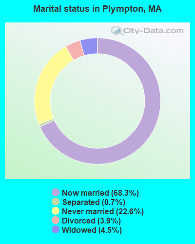
- Never married: 22.6%
- Now married: 68.3%
- Separated: 0.7%
- Widowed: 4.5%
- Divorced: 3.9%
For population 25 years and over in Plympton:
- High school or higher: 92.7%
- Bachelor's degree or higher: 27.3%
- Graduate or professional degree: 12.1%
- Unemployed: 4.0%
- Mean travel time to work (commute): 41.5 minutes
| Here: | 9.8 |
| Massachusetts average: | 13.1 |


Graphs represent county-level data. Detailed 2008 Election Results
Religion statistics for Plympton, MA (based on Plymouth County data)


| Religion | Adherents | Congregations |
|---|---|---|
| Catholic | 165,985 | 35 |
| Mainline Protestant | 23,724 | 91 |
| Evangelical Protestant | 13,159 | 96 |
| Other | 6,129 | 43 |
| Orthodox | 1,140 | 3 |
| Black Protestant | 611 | 5 |
| None | 284,171 | - |
Food Environment Statistics:
| Here: | 1.74 / 10,000 pop. |
| State: | 1.98 / 10,000 pop. |
| Here: | 0.04 / 10,000 pop. |
| Massachusetts: | 0.05 / 10,000 pop. |
| This county: | 2.84 / 10,000 pop. |
| Massachusetts: | 2.22 / 10,000 pop. |
| Plymouth County: | 2.20 / 10,000 pop. |
| State: | 1.77 / 10,000 pop. |
| Plymouth County: | 7.37 / 10,000 pop. |
| Massachusetts: | 8.76 / 10,000 pop. |
| Here: | 7.9% |
| Massachusetts: | 8.1% |
| This county: | 21.7% |
| Massachusetts: | 22.5% |
| Plymouth County: | 16.3% |
| State: | 16.5% |
5.54% of this county's 2020 resident taxpayers moved to other counties in 2021 ($85,482 average adjusted gross income)
| Here: | 5.54% |
| Massachusetts average: | 7.18% |
0.01% of residents moved to foreign countries ($80 average AGI)
Plymouth County: 0.01% Massachusetts average: 0.02%
Top counties to which taxpayers relocated from this county between 2020 and 2021:
| to Bristol County, MA | |
| to Norfolk County, MA | |
| to Suffolk County, MA |
Strongest AM radio stations in Plympton:
- WPLM (1390 AM; 5 kW; PLYMOUTH, MA; Owner: PLYMOUTH ROCK BROADCASTING CO., INC.)
- WBZ (1030 AM; 50 kW; BOSTON, MA; Owner: INFINITY BROADCASTING OPERATIONS, INC.)
- WEEI (850 AM; 50 kW; BOSTON, MA; Owner: ENTERCOM BOSTON LICENSE, LLC)
- WRKO (680 AM; 50 kW; BOSTON, MA; Owner: ENTERCOM BOSTON LICENSE, LLC)
- WALE (990 AM; 50 kW; GREENVILLE, RI; Owner: NORTH AMERICAN BROADCASTING CO., INC.)
- WKOX (1200 AM; 50 kW; FRAMINGHAM, MA; Owner: CAPSTAR TX LIMITED PARTNERSHIP)
- WWZN (1510 AM; 50 kW; BOSTON, MA; Owner: ROSE CITY RADIO CORPORATION)
- WBIX (1060 AM; 40 kW; NATICK, MA; Owner: LANGER BROADCASTING CORPORATION)
- WAMG (890 AM; 25 kW; DEDHAM, MA; Owner: MEGA COMMUNICATIONS OF DEDHAM LICENSEE, LLC)
- WBET (1460 AM; 5 kW; BROCKTON, MA; Owner: KJI BROADCASTING, LLC)
- WCRN (830 AM; 50 kW; WORCESTER, MA; Owner: CARTER BROADCASTING CORPORATION)
- WRCA (1330 AM; 25 kW; WALTHAM, MA; Owner: WRCA LICENSE, LLC)
- WUNR (1600 AM; 20 kW; BROOKLINE, MA; Owner: CHAMPION BROADCASTING SYSTEMS, INC.)
Strongest FM radio stations in Plympton:
- WPLM-FM (99.1 FM; PLYMOUTH, MA; Owner: PLYMOUTH ROCK BROADCASTING CO., INC.)
- WATD-FM (95.9 FM; MARSHFIELD, MA; Owner: MARSHFIELD BROADCASTING CO., INC.)
- WBOT (97.7 FM; BROCKTON, MA; Owner: RADIO ONE LICENSES, LLC)
- WXKS-FM (107.9 FM; MEDFORD, MA; Owner: AMFM RADIO LICENSES, L.L.C.)
- WMJX (106.7 FM; BOSTON, MA; Owner: GREATER BOSTON RADIO, INC.)
- WWBB (101.5 FM; PROVIDENCE, RI; Owner: CLEAR CHANNEL BROADCASTING LICENSES, INC.)
- WBMX (98.5 FM; BOSTON, MA; Owner: INFINITY RADIO OPERATIONS INC.)
- WBOS (92.9 FM; BROOKLINE, MA; Owner: GREATER BOSTON RADIO, INC.)
- WJMN (94.5 FM; BOSTON, MA; Owner: AMFM RADIO LICENSES, L.L.C.)
- WCRB (102.5 FM; WALTHAM, MA; Owner: CHARLES RIVER BROADCASTING WCRB LICE)
- WTKK (96.9 FM; BOSTON, MA; Owner: GREATER BOSTON RADIO, INC.)
- WROR-FM (105.7 FM; FRAMINGHAM, MA; Owner: GREATER BOSTON RADIO, INC.)
- WGBH (89.7 FM; BOSTON, MA; Owner: WGBH EDUCATIONAL FOUNDATION)
- WBUR-FM (90.9 FM; BOSTON, MA; Owner: TRUSTEES OF BOSTON UNIVERSITY)
- WODS (103.3 FM; BOSTON, MA; Owner: INFINITY BROADCASTING OPERATIONS, INC.)
- WBCN (104.1 FM; BOSTON, MA; Owner: HEMISPHERE BROADCASTING CORPORATION)
- WZLX (100.7 FM; BOSTON, MA; Owner: INFINITY BROADCASTING CORPORATION OF BOSTON)
- W267AI (101.3 FM; BOSTON, MA; Owner: MCC BROADCASTING COMPANY, INC.)
- WSNE-FM (93.3 FM; TAUNTON, MA; Owner: CAPSTAR TX LIMITED PARTNERSHIP)
- WERS (88.9 FM; BOSTON, MA; Owner: EMERSON COLLEGE)
TV broadcast stations around Plympton:
- WWDP (Channel 46; NORWELL, MA; Owner: NORWELL TELEVISION, LLC)
- WLWC (Channel 28; NEW BEDFORD, MA; Owner: C-28 FCC LICENSEE SUBSIDIARY, LLC)
- WCVB-TV (Channel 5; BOSTON, MA; Owner: WCVB HEARST-ARGYLE TV, INC.)
- WGBH-TV (Channel 2; BOSTON, MA; Owner: WGBH EDUCATIONAL FOUNDATION)
- WLNE-TV (Channel 6; NEW BEDFORD, MA; Owner: FREEDOM BROADCASTING OF SOUTHERN NEW ENGLAND, INC.)
- WHDH-TV (Channel 7; BOSTON, MA; Owner: WHDH-TV)
- WMFP (Channel 62; LAWRENCE, MA; Owner: WSAH LICENSE, INC.)
- WSBK-TV (Channel 38; BOSTON, MA; Owner: VIACOM INC.)
- WLVI-TV (Channel 56; CAMBRIDGE, MA; Owner: WLVI, INC.)
- WPRI-TV (Channel 12; PROVIDENCE, RI; Owner: TVL BROADCASTING OF RHODE ISLAND, LLC)
- WBZ-TV (Channel 4; BOSTON, MA; Owner: VIACOM INC.)
- WGBX-TV (Channel 44; BOSTON, MA; Owner: WGBH EDUCATIONAL FOUNDATION)
- WNAC-TV (Channel 64; PROVIDENCE, RI; Owner: WNAC, LLC)
- WFXT (Channel 25; BOSTON, MA; Owner: FOX TELEVISION STATIONS INC.)
- WJAR (Channel 10; PROVIDENCE, RI; Owner: OUTLET BROADCASTING, INC.)
- WBPX (Channel 68; BOSTON, MA; Owner: PAXSON BOSTON-68 LICENSE, INC.)
- WSBE-TV (Channel 36; PROVIDENCE, RI; Owner: RHODE ISLAND PUBLIC TELECOM. AUTHORITY)
- WTMU-LP (Channel 32; BOSTON, MA; Owner: ZGS BOSTON, INC.)
- WCEA-LP (Channel 58; BOSTON, MA; Owner: CHANNEL 19 TV CORPORATION)
- W40BO (Channel 40; BOSTON, MA; Owner: PAXSON COMMUNICATIONS LPTV, INC.)
- WUTF (Channel 66; MARLBOROUGH, MA; Owner: TELEFUTURA BOSTON LLC)
Medal of Honor Recipients
Medal of Honor Recipient born in Plympton: Samuel C. Wright.
- National Bridge Inventory (NBI) Statistics
- 2Number of bridges
- 7ft / 1.8mTotal length
- $1,208,000Total costs
- 2,286Total average daily traffic
- 110Total average daily truck traffic
- 4,580Total future (year 2031) average daily traffic
FCC Registered Antenna Towers:
15 (See the full list of FCC Registered Antenna Towers in Plympton)FCC Registered Broadcast Land Mobile Towers:
2- Lat: 41.947444 Lon: -70.772528, Call Sign: WQSC662,
Assigned Frequencies: 456.337 MHz, 457.062 MHz, 457.712 MHz, 457.987 MHz, 467.512 MHz, Grant Date: 09/07/2023, Expiration Date: 09/03/2033, Certifier: Rick Jordan, Registrant: Bearcom, 4009 Distribution Drive, Bldg 200, Garland, TX 75041, Phone: (800) 458-9887, Fax: (210) 656-5182, Email:
- MOBILES, Lat: 41.949889 Lon: -70.800694, Call Sign: WQXU699,
Assigned Frequencies: 458.450 MHz, 458.750 MHz, 458.950 MHz, 458.450 MHz, 458.750 MHz, 458.950 MHz, Grant Date: 06/14/2016, Expiration Date: 06/14/2026, Certifier: Andy Reardon, Registrant: Communications Design And Consulting Group, 9 Tibbetts Road, Barrington, NH 03825, Phone: (603) 905-9406, Fax: (603) 299-0303, Email:
FCC Registered Microwave Towers:
1- BS23XC468, 7 Joey Circle (Lat: 41.952722 Lon: -70.771889), Type: Tower, Structure height: 56.3 m, Overall height: 57.9 m, Call Sign: WQPU666,
Assigned Frequencies: 10935.0 MHz, 10935.0 MHz, 10935.0 MHz, Grant Date: 08/20/2012, Expiration Date: 08/20/2022, Cancellation Date: 04/06/2022, Certifier: David Werblow, Registrant: Dla Piper LLP, 500 8th Street, Nw, Washington, DC 20004, Phone: (202) 799-4216, Fax: (202) 799-5616, Email:
FCC Registered Amateur Radio Licenses:
18 (See the full list of FCC Registered Amateur Radio Licenses in Plympton)FAA Registered Aircraft:
8 (See the full list of FAA Registered Aircraft in Plympton)2002 - 2018 National Fire Incident Reporting System (NFIRS) incidents
- Fire incident types reported to NFIRS in Plympton, MA
- 8948.4%Outside Fires
- 7641.3%Structure Fires
- 168.7%Mobile Property/Vehicle Fires
- 31.6%Other
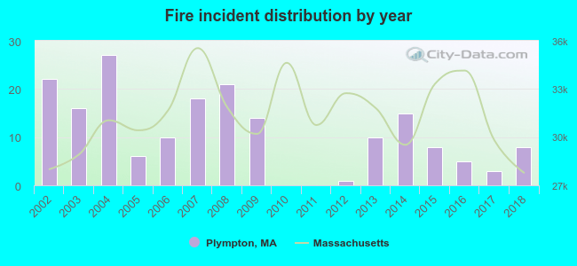 Based on the data from the years 2002 - 2018 the average number of fire incidents per year is 11. The highest number of fire incidents - 27 took place in 2004, and the least - 0 in 2010. The data has a decreasing trend.
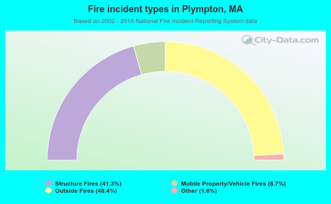 When looking into fire subcategories, the most reports belonged to: Outside Fires (48.4%), and Structure Fires (41.3%).
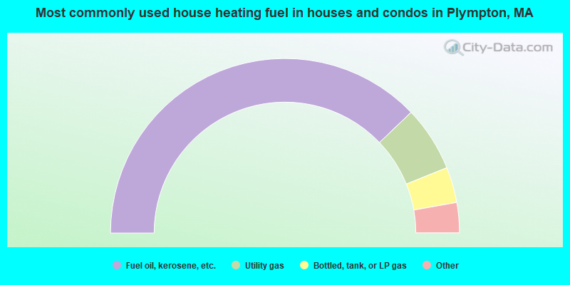
- 75.7%Fuel oil, kerosene, etc.
- 12.1%Utility gas
- 6.6%Bottled, tank, or LP gas
- 2.2%Electricity
- 1.8%Wood
- 1.1%Coal or coke
- 0.5%Solar energy
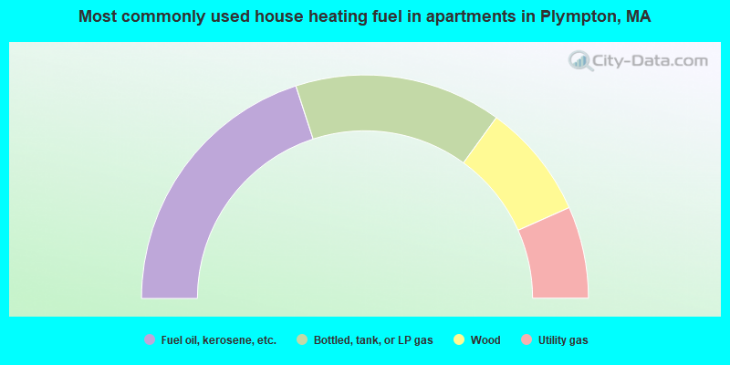
- 40.0%Fuel oil, kerosene, etc.
- 30.0%Bottled, tank, or LP gas
- 16.7%Wood
- 13.3%Utility gas
Plympton compared to Massachusetts state average:
- Unemployed percentage significantly below state average.
- Black race population percentage significantly below state average.
- Hispanic race population percentage significantly below state average.
- Median age above state average.
- Foreign-born population percentage significantly below state average.
- Renting percentage significantly below state average.
- Length of stay since moving in significantly above state average.
- Number of rooms per house significantly below state average.
- House age significantly below state average.

|
|
Total of 19 patent applications in 2008-2024.