Rowe, Massachusetts
Submit your own pictures of this town and show them to the world
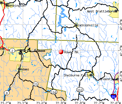
- OSM Map
- General Map
- Google Map
- MSN Map
Population change since 2000: +12.0%
 |
| Males: 188 | |
| Females: 205 |
| Median resident age: | 50.9 years |
| Massachusetts median age: | 39.2 years |
Zip codes: 01367.
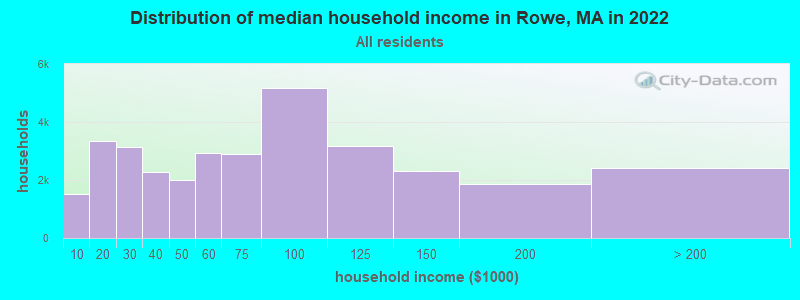
| Rowe: | $72,334 |
| MA: | $94,488 |
Estimated per capita income in 2022: $51,258 (it was $28,134 in 2000)
Rowe town income, earnings, and wages data
Estimated median house or condo value in 2022: $348,670 (it was $140,300 in 2000)
| Rowe: | $348,670 |
| MA: | $534,700 |
Mean prices in 2022: all housing units: $313,377; detached houses: $324,224; townhouses or other attached units: $284,225; in 2-unit structures: $287,978; in 3-to-4-unit structures: $183,938; in 5-or-more-unit structures: $249,762; mobile homes: $62,200


- 38096.7%White alone
- 51.3%Two or more races
- 41.0%Black alone
- 41.0%Hispanic
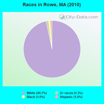
Races in Rowe detailed stats: ancestries, foreign born residents, place of birth
According to our research of Massachusetts and other state lists, there was 1 registered sex offender living in Rowe, Massachusetts as of May 19, 2024.
The ratio of all residents to sex offenders in Rowe is 393 to 1.
 Recent articles from our blog. Our writers, many of them Ph.D. graduates or candidates, create easy-to-read articles on a wide variety of topics.

 | 2024 Real Estate Observations (892 replies) |
| Anyone interested in the upcoming eclipse? (174 replies) |
| 2023 Real Estate Observations (5278 replies) |
| The worst winter in Massachusetts. Is the weather bothering you? (285 replies) |
| How important are school rankings? (119 replies) |
| "All-Inclusive Boston" campaiagn (582 replies) |
Latest news from Rowe, MA collected exclusively by city-data.com from local newspapers, TV, and radio stations
Ancestries: Irish (21.4%), English (17.7%), German (15.4%), French (8.3%), French Canadian (7.7%), Polish (6.8%).
Current Local Time: EST time zone
Incorporated in 1785
Elevation: 1364 feet
Land area: 23.5 square miles.
Population density: 17 people per square mile (very low).
12 residents are foreign born (1.4% North America, 1.1% Latin America, 0.9% Europe).
| This town: | 3.4% |
| Massachusetts: | 12.2% |
| Rowe town: | 0.5% ($771) |
| Massachusetts: | 1.3% ($2,336) |
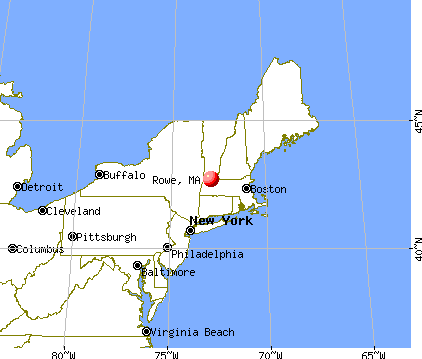
Nearest city with pop. 50,000+: Chicopee, MA  (39.8 miles , pop. 54,653).
Nearest city with pop. 200,000+: Boston, MA (96.3 miles , pop. 589,141).
Nearest city with pop. 1,000,000+: Bronx, NY (137.2 miles , pop. 1,332,650).
Nearest cities:
), ), ), ), Latitude: 42.69 N, Longitude: 72.91 W
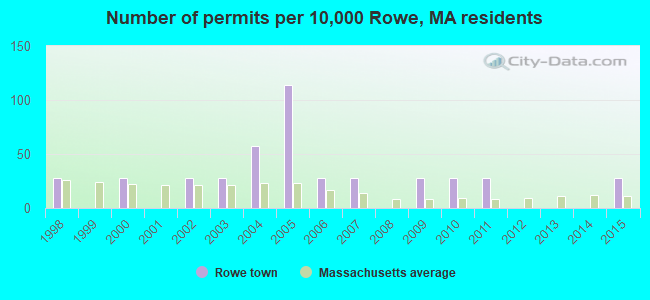
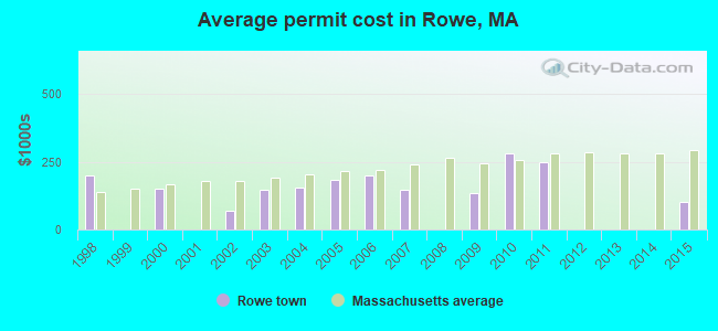
Single-family new house construction building permits:
- 2015: 1 building, cost: $100,000
- 2011: 1 building, cost: $250,000
- 2010: 1 building, cost: $280,000
- 2009: 1 building, cost: $135,000
- 2007: 1 building, cost: $147,600
- 2006: 1 building, cost: $200,000
- 2005: 4 buildings, average cost: $182,500
- 2004: 2 buildings, average cost: $155,000
- 2003: 1 building, cost: $145,000
- 2002: 1 building, cost: $70,000
- 2000: 1 building, cost: $150,000
- 1998: 1 building, cost: $200,000
| Here: | 3.2% |
| Massachusetts: | 3.5% |
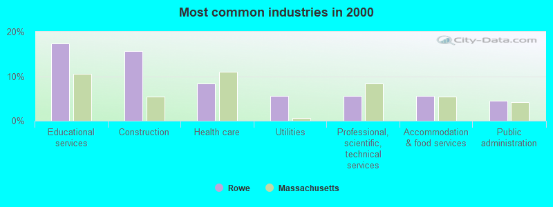
- Educational services (17.3%)
- Construction (15.6%)
- Health care (8.4%)
- Utilities (5.6%)
- Professional, scientific, technical services (5.6%)
- Accommodation & food services (5.6%)
- Public administration (4.5%)
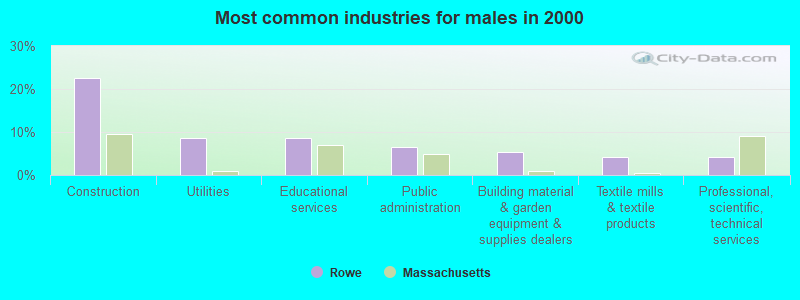
- Construction (22.6%)
- Utilities (8.6%)
- Educational services (8.6%)
- Public administration (6.5%)
- Building material & garden equipment & supplies dealers (5.4%)
- Textile mills & textile products (4.3%)
- Professional, scientific, technical services (4.3%)
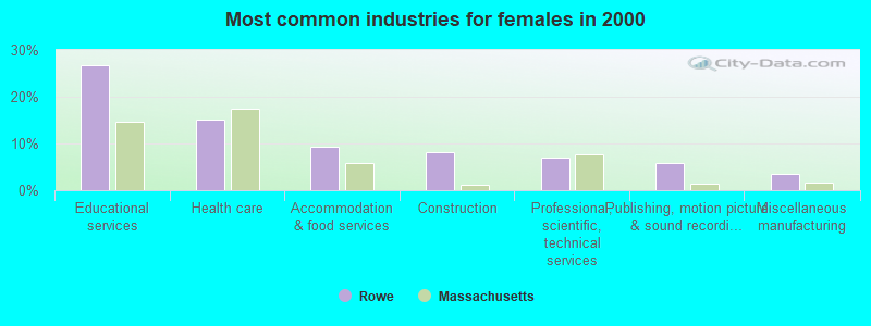
- Educational services (26.7%)
- Health care (15.1%)
- Accommodation & food services (9.3%)
- Construction (8.1%)
- Professional, scientific, technical services (7.0%)
- Publishing, motion picture & sound recording industries (5.8%)
- Miscellaneous manufacturing (3.5%)
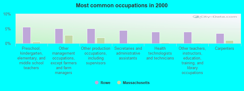
- Preschool, kindergarten, elementary, and middle school teachers (5.6%)
- Other management occupations, except farmers and farm managers (5.0%)
- Other production occupations, including supervisors (5.0%)
- Secretaries and administrative assistants (4.5%)
- Health technologists and technicians (3.9%)
- Other teachers, instructors, education, training, and library occupations (3.9%)
- Carpenters (3.4%)
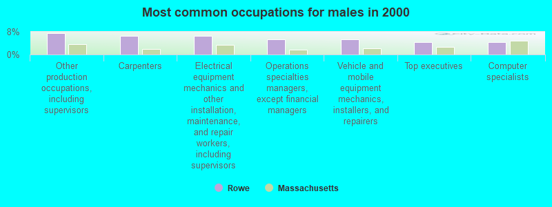
- Other production occupations, including supervisors (7.5%)
- Carpenters (6.5%)
- Electrical equipment mechanics and other installation, maintenance, and repair workers, including supervisors (6.5%)
- Operations specialties managers, except financial managers (5.4%)
- Vehicle and mobile equipment mechanics, installers, and repairers (5.4%)
- Top executives (4.3%)
- Computer specialists (4.3%)

- Preschool, kindergarten, elementary, and middle school teachers (11.6%)
- Secretaries and administrative assistants (9.3%)
- Other management occupations, except farmers and farm managers (8.1%)
- Other teachers, instructors, education, training, and library occupations (8.1%)
- Health technologists and technicians (5.8%)
- Cashiers (5.8%)
- Financial managers (4.7%)
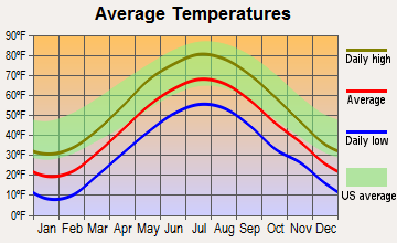
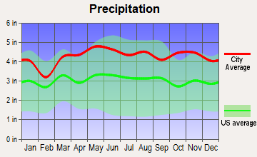
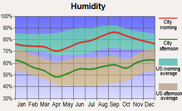
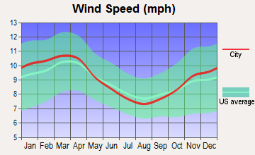
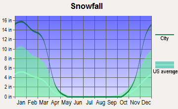
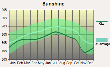
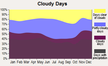
Average climate in Rowe, Massachusetts
Based on data reported by over 4,000 weather stations
(lower is better)
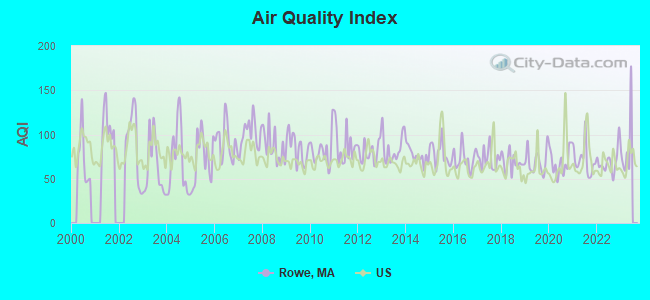
Air Quality Index (AQI) level in 2022 was 69.4. This is about average.
| City: | 69.4 |
| U.S.: | 72.6 |
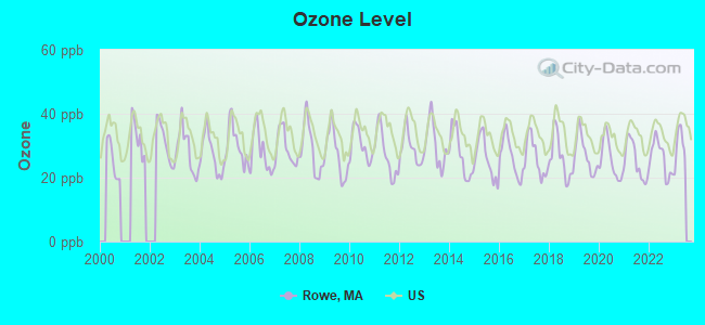
Ozone [ppb] level in 2022 was 26.2. This is better than average. Closest monitor was 15.0 miles away from the city center.
| City: | 26.2 |
| U.S.: | 33.3 |
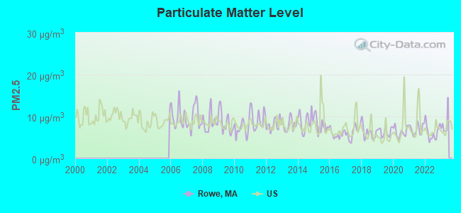
Particulate Matter (PM2.5) [µg/m3] level in 2022 was 6.22. This is better than average. Closest monitor was 10.2 miles away from the city center.
| City: | 6.22 |
| U.S.: | 8.11 |
Tornado activity:
Rowe-area historical tornado activity is slightly above Massachusetts state average. It is 22% smaller than the overall U.S. average.
On 8/28/1973, a category F4 (max. wind speeds 207-260 mph) tornado 32.2 miles away from the Rowe town center killed 4 people and injured 36 people and caused between $5,000,000 and $50,000,000 in damages.
On 5/29/1995, a category F4 tornado 38.7 miles away from the town center killed 3 people and injured 24 people and caused between $5,000,000 and $50,000,000 in damages.
Earthquake activity:
Rowe-area historical earthquake activity is significantly above Massachusetts state average. It is 69% smaller than the overall U.S. average.On 10/7/1983 at 10:18:46, a magnitude 5.3 (5.1 MB, 5.3 LG, 5.1 ML, Class: Moderate, Intensity: VI - VII) earthquake occurred 113.0 miles away from Rowe center
On 4/20/2002 at 10:50:47, a magnitude 5.3 (5.3 ML, Depth: 3.0 mi) earthquake occurred 131.8 miles away from the city center
On 4/20/2002 at 10:50:47, a magnitude 5.2 (5.2 MB, 4.2 MS, 5.2 MW, 5.0 MW) earthquake occurred 130.4 miles away from Rowe center
On 1/19/1982 at 00:14:42, a magnitude 4.7 (4.5 MB, 4.7 MD, 4.5 LG, Class: Light, Intensity: IV - V) earthquake occurred 86.5 miles away from the city center
On 10/16/2012 at 23:12:25, a magnitude 4.7 (4.7 ML, Depth: 10.0 mi) earthquake occurred 129.7 miles away from Rowe center
On 6/17/1991 at 08:53:16, a magnitude 4.1 (4.0 MB, 4.0 LG, Depth: 3.1 mi) earthquake occurred 90.1 miles away from the city center
Magnitude types: regional Lg-wave magnitude (LG), body-wave magnitude (MB), duration magnitude (MD), local magnitude (ML), surface-wave magnitude (MS), moment magnitude (MW)
Natural disasters:
The number of natural disasters in Franklin County (20) is greater than the US average (15).Major Disasters (Presidential) Declared: 9
Emergencies Declared: 10
Causes of natural disasters: Floods: 5, Storms: 5, Hurricanes: 4, Snowstorms: 4, Winter Storms: 3, Blizzards: 2, Snows: 2, Snowfall: 1, Tropical Storm: 1, Wind: 1, Other: 1 (Note: some incidents may be assigned to more than one category).

Hospitals and medical centers near Rowe:
- NORTH ADAMS COMMONS NURSING AND REHABILITATION CENTE (Nursing Home, about 10 miles away; NORTH ADAMS, MA)
- ADAMS N H OF N ADAMS (Nursing Home, about 11 miles away; NORTH ADAMS, MA)
- NORTH ADAMS REGIONAL HOSPITAL Acute Care Hospitals (about 11 miles away; NORTH ADAMS, MA)
- NORTHERN BERKSHIRE COMPREHENSIVE CARE (Home Health Center, about 11 miles away; ADAMS, MA)
- HOSPICE OF N BERKSHIRE INC (Hospital, about 11 miles away; ADAMS, MA)
- ANCHORAGE NURSING HOME (Nursing Home, about 14 miles away; SHELBURNE, MA)
- WILLIAMSTOWN COMMONS NURSING AND REHAB (Nursing Home, about 15 miles away; WILLIAMSTOWN, MA)
Nuclear power plants:
Yankee Rowe . Pressurized Water Reactor (PWR). Net Output: 167 MWe. Permanently shutdown. Date started: 07/1961. Date closed : 09/1991..
Colleges/universities with over 2000 students nearest to Rowe:
- Williams College (about 16 miles; Williamstown, MA; Full-time enrollment: 2,141)
- University of Massachusetts-Amherst (about 29 miles; Amherst, MA; FT enrollment: 26,583)
- Smith College (about 30 miles; Northampton, MA; FT enrollment: 3,549)
- Mount Holyoke College (about 35 miles; South Hadley, MA; FT enrollment: 2,573)
- Keene State College (about 36 miles; Keene, NH; FT enrollment: 5,098)
- Holyoke Community College (about 37 miles; Holyoke, MA; FT enrollment: 4,911)
- Rensselaer Polytechnic Institute (about 40 miles; Troy, NY; FT enrollment: 6,940)
Points of interest:
Notable locations in Rowe: Hoosac Tunnel Station (A), Rowe Camp (B), Yankee Atomic Powerplant (C), Heywoods Station (D), Logan Station (E), Rowe Fire Department (F). Display/hide their locations on the map
Cemeteries: East Cemetery (1), West Cemetery (2), North Cemetery (3). Display/hide their locations on the map
Reservoirs and swamps: Upper Reservoir Bear Swamp (A), Lower Reservoir Bear Swamp (B), Pelham Lake (C), Bear Swamp Upper Reservoir (D), Deerfield River Reservoir (E), Bear Swamp (F). Display/hide their locations on the map
Streams, rivers, and creeks: Wheeler Brook (A), Tuttle Brook (B), Taylor Brook (C), Shippee Brook (D), Sam Rice Brook (E), Potter Brook (F), Phelps Brook (G), Lord Brook (H), Dunbar Brook (I). Display/hide their locations on the map
Park in Rowe: Pelham Lake Park (1). Display/hide its location on the map
Birthplace of: Edward S. Wilkinson - Politician.
| This town: | 2.4 people |
| Massachusetts: | 2.5 people |
| This town: | 67.1% |
| Whole state: | 63.0% |
| This town: | 6.0% |
| Whole state: | 7.0% |
Likely homosexual households (counted as self-reported same-sex unmarried-partner households)
- Lesbian couples: 0.6% of all households
- Gay men: 0.0% of all households
| This town: | 2.8% |
| Whole state: | 9.3% |
| This town: | 0.8% |
| Whole state: | 4.4% |
For population 15 years and over in Rowe:
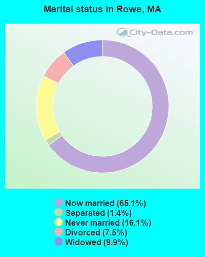
- Never married: 16.1%
- Now married: 65.1%
- Separated: 1.4%
- Widowed: 9.9%
- Divorced: 7.5%
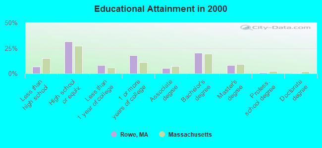
For population 25 years and over in Rowe:
- High school or higher: 93.4%
- Bachelor's degree or higher: 30.1%
- Graduate or professional degree: 9.7%
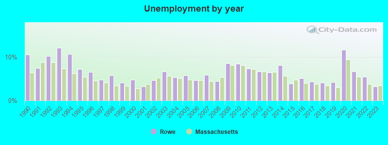
- Unemployed: 2.7%
- Mean travel time to work (commute): 34.9 minutes
| Here: | 9.1 |
| Massachusetts average: | 13.1 |


Graphs represent county-level data. Detailed 2008 Election Results
Religion statistics for Rowe, MA (based on Franklin County data)


| Religion | Adherents | Congregations |
|---|---|---|
| Catholic | 16,509 | 15 |
| Mainline Protestant | 4,617 | 38 |
| Evangelical Protestant | 2,079 | 20 |
| Other | 1,580 | 21 |
| None | 46,587 | - |
Food Environment Statistics:
| Franklin County: | 3.63 / 10,000 pop. |
| Massachusetts: | 1.98 / 10,000 pop. |
| Franklin County: | 0.14 / 10,000 pop. |
| Massachusetts: | 0.05 / 10,000 pop. |
| This county: | 1.67 / 10,000 pop. |
| Massachusetts: | 2.22 / 10,000 pop. |
| This county: | 3.21 / 10,000 pop. |
| Massachusetts: | 1.77 / 10,000 pop. |
| Franklin County: | 8.10 / 10,000 pop. |
| Massachusetts: | 8.76 / 10,000 pop. |
| Franklin County: | 7.5% |
| Massachusetts: | 8.1% |
| Here: | 22.2% |
| State: | 22.5% |
| This county: | 15.1% |
| Massachusetts: | 16.5% |
Strongest AM radio stations in Rowe:
- WNNZ (640 AM; 50 kW; WESTFIELD, MA; Owner: CLEAR CHANNEL BROADCASTING LICENSES, INC.)
- WIZZ (1520 AM; daytime; 10 kW; GREENFIELD, MA; Owner: P. & M. RADIO, LLC)
- WGY (810 AM; 50 kW; SCHENECTADY, NY; Owner: CLEAR CHANNEL BROADCASTING LICENSES, INC.)
- WCRN (830 AM; 50 kW; WORCESTER, MA; Owner: CARTER BROADCASTING CORPORATION)
- WPTR (1540 AM; 50 kW; ALBANY, NY; Owner: KIMTRON, INC.)
- WVNE (760 AM; daytime; 25 kW; LEICESTER, MA; Owner: BLOUNT MASSCOM, INC.)
- WTIC (1080 AM; 50 kW; HARTFORD, CT; Owner: INFINITY RADIO OPERATIONS INC.)
- WRKO (680 AM; 50 kW; BOSTON, MA; Owner: ENTERCOM BOSTON LICENSE, LLC)
- WNAW (1230 AM; 1 kW; NORTH ADAMS, MA; Owner: BERKSHIRE BROADCASTING CO., INC.)
- WEEI (850 AM; 50 kW; BOSTON, MA; Owner: ENTERCOM BOSTON LICENSE, LLC)
- WALE (990 AM; 50 kW; GREENVILLE, RI; Owner: NORTH AMERICAN BROADCASTING CO., INC.)
- WUHN (1110 AM; daytime; 5 kW; PITTSFIELD, MA; Owner: WEINER BROADCASTING, INC.)
- WKOX (1200 AM; 50 kW; FRAMINGHAM, MA; Owner: CAPSTAR TX LIMITED PARTNERSHIP)
Strongest FM radio stations in Rowe:
- WAMC-FM (90.3 FM; ALBANY, NY; Owner: WAMC)
- WMNB (100.1 FM; NORTH ADAMS, MA; Owner: BERKSHIRE BROADCASTING CO., INC.)
- WVAY (100.7 FM; WILMINGTON, VT; Owner: GREAT NORTHERN RADIO, L.L.C.)
- WEQX (102.7 FM; MANCHESTER, VT; Owner: NORTHSHIRE COMMUNICATIONS, INC.)
- WJAN (95.1 FM; SUNDERLAND, VT; Owner: 6 JOHNSON ROAD LICENSES, INC.)
- WPVQ (95.3 FM; GREENFIELD, MA; Owner: GREAT NORTHERN RADIO, L.L.C.)
- WRSY (101.5 FM; MARLBORO, VT; Owner: GREAT NORTHERN RADIO, L.L.C.)
- WZEC (97.5 FM; HOOSICK FALLS, NY; Owner: GREAT NORTHERN RADIO, LLC)
- WKVT-FM (92.7 FM; BRATTLEBORO, VT; Owner: SAGA COMMUNICATIONS OF NEW ENGLAND, LLC)
- WHAI (98.3 FM; GREENFIELD, MA; Owner: SAGA COMMUNICATIONS OF NEW ENGLAND, LLC)
- WCMK (91.9 FM; PUTNEY, VT; Owner: CHRISTIAN MINISTRIES INC)
- WJJR (98.1 FM; RUTLAND, VT; Owner: 6 JOHNSON ROAD LICENSES, INC.)
- WZRT (97.1 FM; RUTLAND, VT; Owner: CAPSTAR TX LIMITED PARTNERSHIP)
- WHDQ (106.1 FM; CLAREMONT, NH; Owner: GREAT NORTHERN RADIO, L.L.C.)
- WVPR (89.5 FM; WINDSOR, VT; Owner: VERMONT PUBLIC RADIO)
- WYRY (104.9 FM; HINSDALE, NH; Owner: TRI-VALLEY BROADCASTING CORPORATION)
- WEBK (105.3 FM; KILLINGTON, VT; Owner: 6 JOHNSON ROAD LICENSES, INC.)
- WRSI (93.9 FM; TURNERS FALLS, MA; Owner: GREAT NORTHERN RADIO, LLC)
- WHYN-FM (93.1 FM; SPRINGFIELD, MA; Owner: CLEAR CHANNEL BROADCASTING LICENSES, INC.)
- WFCR (88.5 FM; AMHERST, MA; Owner: UNIVERSITY OF MASSACHUSETTS)
TV broadcast stations around Rowe:
- W35BK (Channel 35; PLAINFIELD, MA; Owner: LYDIA SYLVANE STOCKWELL)
- WCDC-TV (Channel 19; ADAMS, MA; Owner: YOUNG BROADCASTING OF ALBANY, INC.)
- W38DL (Channel 38; ADAMS, ETC., MA; Owner: WNYT-TV, LLC)
Rowe fatal accident list:
- National Bridge Inventory (NBI) Statistics
- 5Number of bridges
- 13ft / 4.3mTotal length
- $4,060,000Total costs
- 2,784Total average daily traffic
- 173Total average daily truck traffic
FCC Registered Antenna Towers:
6- Jeffrey M Martin, Dike Bear Swamp (Lat: 42.684806 Lon: -72.959000), Type: 91.4, Overall height: 91.4 m, Registrant: Patton Boggs LLP, Washi-ngton, Phone: (202) 457-5668
- Ernest K Hauser, Dike Bear Swamp (Lat: 42.684806 Lon: -72.959000), Type: 91.4, Overall height: 91.4 m, Registrant: Wiley, Rein & Fielding, Tdombrow@wrf.Com, , Washi-ngton, Phone: (202) 719-7236
- Ernest K Hauser, Dike Bear Swamp (Lat: 42.684806 Lon: -72.959000), Type: 91.4, Overall height: 91.4 m, Registrant: Wiley, Rein & Fielding, Tdombrow@wrf.Com, , Washi-ngton, Phone: (202) 719-7236
- Stephen F Hartman, Dike Bear Swamp, Type: 91.4, Structure height: 25011 m, Overall height: 91.4 m, Registrant: Bear Swamp Power Co. LLC, Stephen.Hartman@brookfieldrenewable.Com, , 461 Rowe, Phone: (202) 457-5668
- Stephen F Hartman, Dike Bear Swamp (Lat: 42.684806 Lon: -72.959000), Type: 91.4, Structure height: 25011 m, Overall height: 91.4 m, Registrant: Bear Swamp Power Company LLC, Stephen.Hartman@brookfieldrenewable.Com, , Flori-da, Phone: (802) 423-7015
- Bear Swamp Upper Reservoir (Lat: 42.683611 Lon: -72.952500), Type: 91.5, Registrant: New England Power Service Company, Westb-orough, Phone: (508) 389-2000
FCC Registered Broadcast Land Mobile Towers:
6- 4 Sibley Rd (Lat: 42.695083 Lon: -72.898167), Type: Building, Structure height: 12 m, Overall height: 17 m, Call Sign: KCI282,
Assigned Frequencies: 155.820 MHz, Grant Date: 05/01/2013, Expiration Date: 07/13/2023, Cancellation Date: 09/16/2023, Certifier: Edwin L May, Registrant: Washington Radio Reports, 1588 Fairfield Rd Ste 7, Gettysburg, PA 17325, Phone: (717) 334-0668, Fax: (717) 334-6440
- SHERMAN STATION, 48 Yankee Rd - Sherman Hydroelectric Station (Lat: 42.729139 Lon: -72.930917), Type: Building, Structure height: 8.3 m, Overall height: 12 m, Call Sign: WPLY374,
Assigned Frequencies: 48.9600 MHz, Grant Date: 03/25/2023, Expiration Date: 04/13/2033, Certifier: Daniel R Revers, Registrant: Great River Hydro, LLC, 69 Milk Street, Suite 306, Westborough, MA 01581, Phone: (508) 614-0734, Email:
- 49 Yankee Rd (Lat: 42.727861 Lon: -72.930111), Type: Building, Structure height: 6 m, Overall height: 9 m, Call Sign: WPMN261,
Assigned Frequencies: 451.975 MHz, Grant Date: 10/02/2003, Expiration Date: 09/28/2013, Cancellation Date: 09/23/2013, Certifier: Frederick Williams, Registrant: Yankee Atomic Electric Company, 49 Yankee Rd, Rowe, MA 01367, Phone: (413) 424-5261, Fax: (413) 424-5395, Email:
- Edge No Dike Bear Swamp Upper Reservoir (Lat: 42.685361 Lon: -72.949833), Call Sign: KWG262,
Assigned Frequencies: 48.2800 MHz, 48.4800 MHz, 47.9600 MHz, 48.5000 MHz, Grant Date: 08/06/2022, Expiration Date: 09/23/2032, Registrant: Utilities Technology Council, 2550 South Clark St., Suite 960, Arlington, VA 22202, Phone: (202) 833-6818, Fax: (202) 872-1331, Email:
- Bear Swamp N Dike Off Tunnel Rd (Lat: 42.685361 Lon: -72.949833), Call Sign: WAF379,
Assigned Frequencies: 37.6000 MHz, Grant Date: 10/08/2021, Expiration Date: 10/16/2031, Certifier: Jeffrey M Martin, Registrant: Bear Swamp Power Company, 370 River Road, Rowe, MA 01367, Phone: (802) 423-7015, Fax: (802) 423-5363, Email:
- Bear Swamp Ipper Reservoir (Lat: 42.683694 Lon: -72.952611), Call Sign: WRM31,
Assigned Frequencies: 173.203 MHz, Grant Date: 08/30/2002, Expiration Date: 09/23/2012, Cancellation Date: 11/24/2012, Certifier: Jeffrey M Martin, Registrant: Bear Swamp Power Company, 100 International Drive, Suite 350, Portsmouth, NH 03801, Phone: (603) 766-4320
FCC Registered Microwave Towers:
3- STATION, Ma Yankee Atomic Power Plant (Lat: 42.728389 Lon: -72.928417), Structure height: 7.6 m, Overall height: 12.2 m, Call Sign: WPP91,
Assigned Frequencies: 6835.00 MHz, Grant Date: 01/21/2000, Expiration Date: 02/08/2010, Cancellation Date: 05/22/2003, Registrant: Keller And Heckman LLP, 1001 G Street, N.W. Suite 500 West, Washington, DC 20001, Phone: (202) 434-4130, Fax: (202) 434-4646, Email:
- STATION, Bear Swamp Switchyard Tunnel Rd (Lat: 42.683389 Lon: -72.949250), Overall height: 9.1 m, Call Sign: WPP92,
Assigned Frequencies: 6565.00 MHz, Grant Date: 02/04/2020, Expiration Date: 02/08/2030, Registrant: Utilities Technology Council, 2550 South Clark St., Suite 960, Arlington, VA 22202, Phone: (202) 872-0030, Fax: (202) 872-1331, Email:
- STATION, Transformer Portal 3.22 Mi Azimuth 264 Degrees From (Lat: 42.687556 Lon: -72.961472), Overall height: 7.6 m, Call Sign: WPP94,
Assigned Frequencies: 6595.00 MHz, 6695.00 MHz, Grant Date: 02/04/2020, Expiration Date: 02/08/2030, Registrant: Utilities Technology Council, 2550 South Clark St., Suite 960, Arlington, VA 22202, Phone: (202) 872-0030, Fax: (202) 872-1331, Email:
FCC Registered Amateur Radio Licenses:
4- Call Sign: KB1WEK, Licensee ID: L01668036, Grant Date: 10/20/2011, Expiration Date: 10/20/2021, Cancellation Date: 05/16/2015, Certifier: Daniel J Miller, Registrant: Daniel J Miller, Rowe, MA 01367
- Call Sign: KO1V, Previous Call Sign: KB1WEK, Licensee ID: L01668036, Grant Date: 05/16/2015, Expiration Date: 05/16/2025, Certifier: Daniel J Miller, Registrant: Daniel J Miller, Rowe, MA 01367
- Call Sign: KC1IYF, Licensee ID: L02159360, Grant Date: 02/02/2018, Expiration Date: 02/02/2028, Certifier: Bradley J Rice, Registrant: Bradley J Rice, 86 Ford Hill Rd, Rowe, MA 01367
- Call Sign: KC1JFB, Licensee ID: L02167819, Grant Date: 03/07/2018, Expiration Date: 03/07/2028, Certifier: Amy B Hicks, Registrant: Amy B Hicks, 86 Ford Hill Rd, Rowe, MA 01367
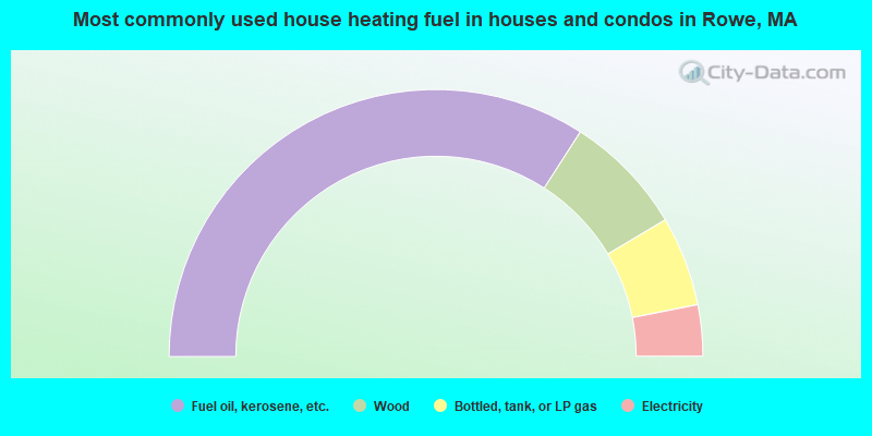
- 68.2%Fuel oil, kerosene, etc.
- 14.7%Wood
- 10.9%Bottled, tank, or LP gas
- 6.2%Electricity
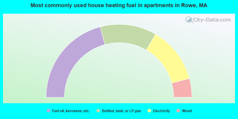
- 41.7%Fuel oil, kerosene, etc.
- 25.0%Bottled, tank, or LP gas
- 25.0%Electricity
- 8.3%Wood
Rowe compared to Massachusetts state average:
- Median house value below state average.
- Unemployed percentage significantly below state average.
- Black race population percentage significantly below state average.
- Hispanic race population percentage significantly below state average.
- Median age significantly above state average.
- Foreign-born population percentage significantly below state average.
- Renting percentage significantly below state average.
- Length of stay since moving in significantly above state average.
- Number of rooms per house significantly below state average.
- House age significantly below state average.
- Number of college students significantly below state average.