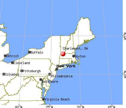
Charlemont, Massachusetts
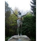
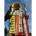
Charlemont: "Hail to the Sunrise" statue
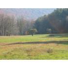
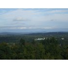
Charlemont: From the Beast
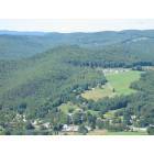
Charlemont: Meadows, Mohawk State Park
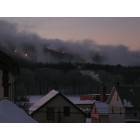
Charlemont: making snow - early morning
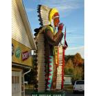
Charlemont: Indian - Charlemont, MA
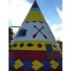
Charlemont: Indian Plaza - Charlemont, MA
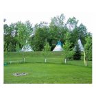
Charlemont: 3 tipi's at indian plaza Charlemont 2006
Charlemont: Charlemont, MA
Charlemont: Long View Info Center
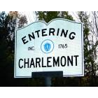
Charlemont: Entering Charlemont, MA
- add
your
Submit your own pictures of this town and show them to the world
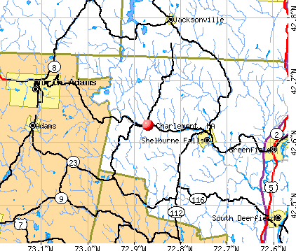
- OSM Map
- General Map
- Google Map
- MSN Map
Population change since 2000: -6.8%
 |
| Males: 625 | |
| Females: 641 |
| Median resident age: | 46.5 years |
| Massachusetts median age: | 39.2 years |
Zip codes: 01339.
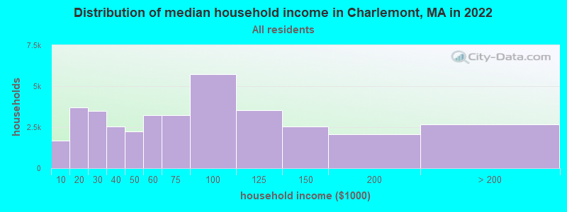
| Charlemont: | $80,274 |
| MA: | $94,488 |
Estimated per capita income in 2022: $35,668 (it was $19,577 in 2000)
Charlemont town income, earnings, and wages data
Estimated median house or condo value in 2022: $282,564 (it was $113,700 in 2000)
| Charlemont: | $282,564 |
| MA: | $534,700 |
Mean prices in 2022: all housing units: $313,377; detached houses: $324,224; townhouses or other attached units: $284,225; in 2-unit structures: $287,978; in 3-to-4-unit structures: $183,938; in 5-or-more-unit structures: $249,762; mobile homes: $62,200
Detailed information about poverty and poor residents in Charlemont, MA


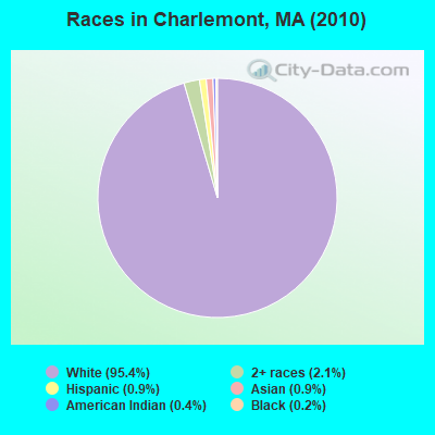
- 1,20895.4%White alone
- 272.1%Two or more races
- 110.9%Asian alone
- 120.9%Hispanic
- 50.4%American Indian alone
- 20.2%Black alone
- 10.08%Other race alone
Races in Charlemont detailed stats: ancestries, foreign born residents, place of birth
According to our research of Massachusetts and other state lists, there were 5 registered sex offenders living in Charlemont, Massachusetts as of May 20, 2024.
The ratio of all residents to sex offenders in Charlemont is 253 to 1.
Type |
2009 |
2010 |
|---|---|---|
| Murders (per 100,000) | 0 (0.0) | 0 (0.0) |
| Rapes (per 100,000) | 0 (0.0) | 0 (0.0) |
| Robberies (per 100,000) | 0 (0.0) | 0 (0.0) |
| Assaults (per 100,000) | 1 (72.3) | 0 (0.0) |
| Burglaries (per 100,000) | 0 (0.0) | 1 (79.0) |
| Thefts (per 100,000) | 6 (433.8) | 1 (79.0) |
| Auto thefts (per 100,000) | 0 (0.0) | 1 (79.0) |
| Arson (per 100,000) | 0 (0.0) | 0 (0.0) |
| City-Data.com crime index | 31.8 | 15.0 |
The City-Data.com crime index weighs serious crimes and violent crimes more heavily. Higher means more crime, U.S. average is 246.1. It adjusts for the number of visitors and daily workers commuting into cities.
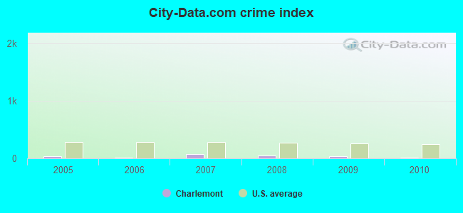
Crime rate in Charlemont detailed stats: murders, rapes, robberies, assaults, burglaries, thefts, arson
 Recent articles from our blog. Our writers, many of them Ph.D. graduates or candidates, create easy-to-read articles on a wide variety of topics.


Latest news from Charlemont, MA collected exclusively by city-data.com from local newspapers, TV, and radio stations
Ancestries: Irish (19.2%), English (18.5%), French (13.5%), German (10.5%), Polish (9.8%), United States (8.6%).
Current Local Time: EST time zone
Incorporated in 1765
Elevation: 679 feet
Land area: 26.1 square miles.
Population density: 49 people per square mile (very low).
36 residents are foreign born (1.0% Asia, 0.8% Europe, 0.6% Latin America).
| This town: | 2.7% |
| Massachusetts: | 12.2% |
| Charlemont town: | 1.8% ($2,035) |
| Massachusetts: | 1.3% ($2,336) |
Nearest city with pop. 50,000+: Chicopee, MA  (34.8 miles , pop. 54,653).
Nearest city with pop. 200,000+: Boston, MA (93.2 miles , pop. 589,141).
Nearest city with pop. 1,000,000+: Bronx, NY (133.8 miles , pop. 1,332,650).
Nearest cities:
), ), ), ), )Latitude: 42.63 N, Longitude: 72.87 W
Area code: 413

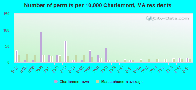
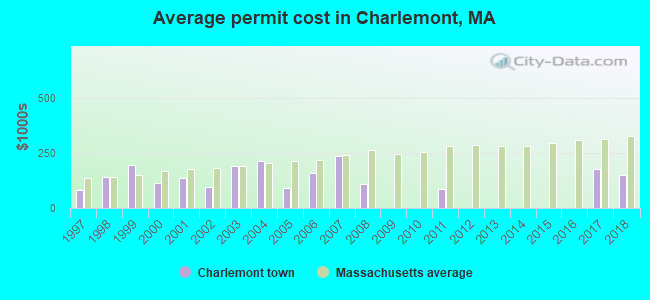
Single-family new house construction building permits:
- 2018: 2 buildings, average cost: $150,000
- 2017: 2 buildings, average cost: $175,000
- 2011: 1 building, cost: $87,500
- 2008: 6 buildings, average cost: $110,900
- 2007: 3 buildings, average cost: $238,400
- 2006: 5 buildings, average cost: $157,300
- 2005: 1 building, cost: $89,600
- 2004: 1 building, cost: $213,700
- 2003: 9 buildings, average cost: $192,000
- 2002: 3 buildings, average cost: $95,300
- 2001: 3 buildings, average cost: $133,800
- 2000: 13 buildings, average cost: $114,100
- 1999: 1 building, cost: $194,200
- 1998: 1 building, cost: $141,600
- 1997: 5 buildings, average cost: $82,300
| Here: | 6.3% |
| Massachusetts: | 3.5% |
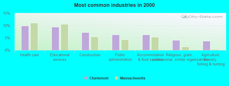
- Health care (9.9%)
- Educational services (9.4%)
- Construction (7.2%)
- Public administration (6.3%)
- Accommodation & food services (6.3%)
- Religious, grantmaking, civic, professional, similar organizations (4.0%)
- Agriculture, forestry, fishing & hunting (3.8%)
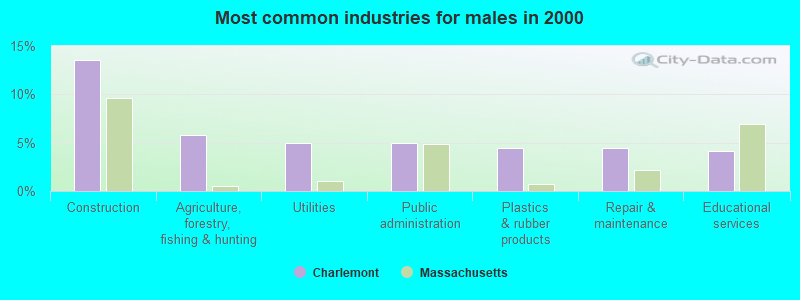
- Construction (13.5%)
- Agriculture, forestry, fishing & hunting (5.8%)
- Utilities (5.0%)
- Public administration (5.0%)
- Plastics & rubber products (4.4%)
- Repair & maintenance (4.4%)
- Educational services (4.1%)
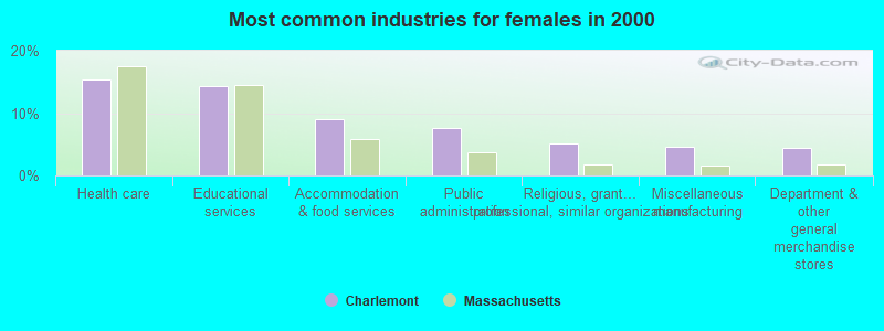
- Health care (15.4%)
- Educational services (14.3%)
- Accommodation & food services (9.1%)
- Public administration (7.6%)
- Religious, grantmaking, civic, professional, similar organizations (5.2%)
- Miscellaneous manufacturing (4.7%)
- Department & other general merchandise stores (4.4%)
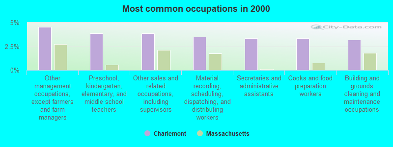
- Other management occupations, except farmers and farm managers (4.6%)
- Preschool, kindergarten, elementary, and middle school teachers (3.9%)
- Other sales and related occupations, including supervisors (3.9%)
- Material recording, scheduling, dispatching, and distributing workers (3.5%)
- Secretaries and administrative assistants (3.4%)
- Cooks and food preparation workers (3.4%)
- Building and grounds cleaning and maintenance occupations (3.2%)
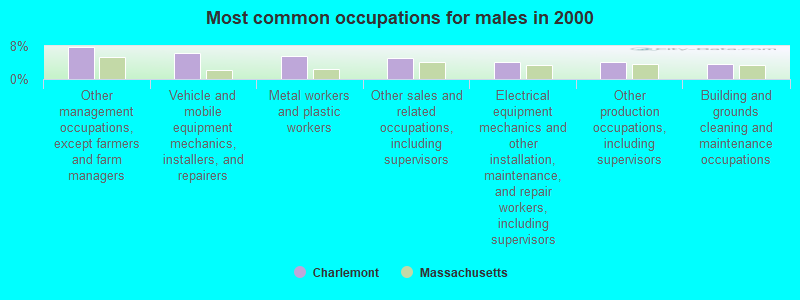
- Other management occupations, except farmers and farm managers (7.7%)
- Vehicle and mobile equipment mechanics, installers, and repairers (6.4%)
- Metal workers and plastic workers (5.5%)
- Other sales and related occupations, including supervisors (5.0%)
- Electrical equipment mechanics and other installation, maintenance, and repair workers, including supervisors (4.1%)
- Other production occupations, including supervisors (4.1%)
- Building and grounds cleaning and maintenance occupations (3.6%)
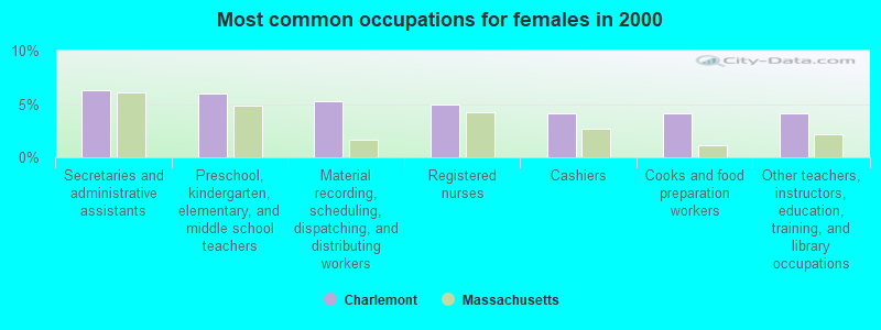
- Secretaries and administrative assistants (6.2%)
- Preschool, kindergarten, elementary, and middle school teachers (6.0%)
- Material recording, scheduling, dispatching, and distributing workers (5.2%)
- Registered nurses (4.9%)
- Cashiers (4.2%)
- Cooks and food preparation workers (4.2%)
- Other teachers, instructors, education, training, and library occupations (4.2%)
Average climate in Charlemont, Massachusetts
Based on data reported by over 4,000 weather stations


(lower is better)
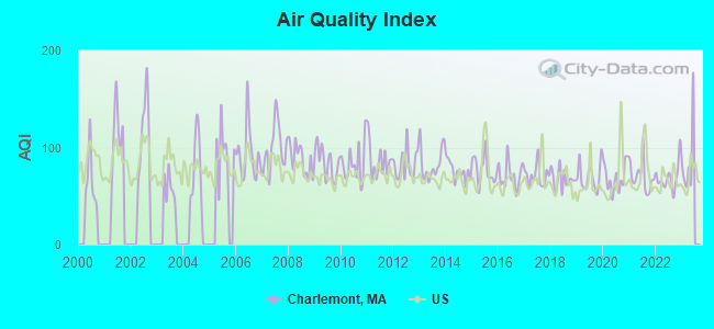
Air Quality Index (AQI) level in 2022 was 69.0. This is about average.
| City: | 69.0 |
| U.S.: | 72.6 |
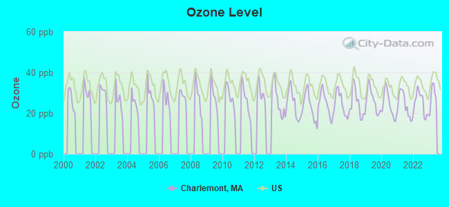
Ozone [ppb] level in 2022 was 24.8. This is better than average. Closest monitor was 13.9 miles away from the city center.
| City: | 24.8 |
| U.S.: | 33.3 |
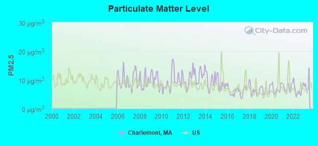
Particulate Matter (PM2.5) [µg/m3] level in 2022 was 6.58. This is better than average. Closest monitor was 13.4 miles away from the city center.
| City: | 6.58 |
| U.S.: | 8.11 |
Tornado activity:
Charlemont-area historical tornado activity is slightly above Massachusetts state average. It is 19% smaller than the overall U.S. average.
On 8/28/1973, a category F4 (max. wind speeds 207-260 mph) tornado 31.7 miles away from the Charlemont town center killed 4 people and injured 36 people and caused between $5,000,000 and $50,000,000 in damages.
On 5/29/1995, a category F4 tornado 35.4 miles away from the town center killed 3 people and injured 24 people and caused between $5,000,000 and $50,000,000 in damages.
Earthquake activity:
Charlemont-area historical earthquake activity is significantly above Massachusetts state average. It is 69% smaller than the overall U.S. average.On 10/7/1983 at 10:18:46, a magnitude 5.3 (5.1 MB, 5.3 LG, 5.1 ML, Class: Moderate, Intensity: VI - VII) earthquake occurred 117.8 miles away from Charlemont center
On 4/20/2002 at 10:50:47, a magnitude 5.3 (5.3 ML, Depth: 3.0 mi) earthquake occurred 136.7 miles away from the city center
On 4/20/2002 at 10:50:47, a magnitude 5.2 (5.2 MB, 4.2 MS, 5.2 MW, 5.0 MW) earthquake occurred 135.3 miles away from the city center
On 1/19/1982 at 00:14:42, a magnitude 4.7 (4.5 MB, 4.7 MD, 4.5 LG, Class: Light, Intensity: IV - V) earthquake occurred 87.8 miles away from Charlemont center
On 10/16/2012 at 23:12:25, a magnitude 4.7 (4.7 ML, Depth: 10.0 mi) earthquake occurred 130.1 miles away from Charlemont center
On 6/17/1991 at 08:53:16, a magnitude 4.1 (4.0 MB, 4.0 LG, Depth: 3.1 mi) earthquake occurred 92.2 miles away from Charlemont center
Magnitude types: regional Lg-wave magnitude (LG), body-wave magnitude (MB), duration magnitude (MD), local magnitude (ML), surface-wave magnitude (MS), moment magnitude (MW)
Natural disasters:
The number of natural disasters in Franklin County (20) is greater than the US average (15).Major Disasters (Presidential) Declared: 9
Emergencies Declared: 10
Causes of natural disasters: Floods: 5, Storms: 5, Hurricanes: 4, Snowstorms: 4, Winter Storms: 3, Blizzards: 2, Snows: 2, Snowfall: 1, Tropical Storm: 1, Wind: 1, Other: 1 (Note: some incidents may be assigned to more than one category).
Hospitals and medical centers near Charlemont:
- ANCHORAGE NURSING HOME (Nursing Home, about 10 miles away; SHELBURNE, MA)
- NORTHERN BERKSHIRE COMPREHENSIVE CARE (Home Health Center, about 13 miles away; ADAMS, MA)
- HOSPICE OF N BERKSHIRE INC (Hospital, about 13 miles away; ADAMS, MA)
- CHARLENE MANOR EXTENDED CARE FACILITY (Nursing Home, about 13 miles away; GREENFIELD, MA)
- NORTH ADAMS COMMONS NURSING AND REHABILITATION CENTE (Nursing Home, about 14 miles away; NORTH ADAMS, MA)
- HOSPICE OF FRANKLIN COUNTY, INC (Hospital, about 14 miles away; GREENFIELD, MA)
- FRANKLIN CENTER (Nursing Home, about 14 miles away; GREENFIELD, MA)
Colleges/universities with over 2000 students nearest to Charlemont:
- Williams College (about 19 miles; Williamstown, MA; Full-time enrollment: 2,141)
- University of Massachusetts-Amherst (about 25 miles; Amherst, MA; FT enrollment: 26,583)
- Smith College (about 25 miles; Northampton, MA; FT enrollment: 3,549)
- Mount Holyoke College (about 30 miles; South Hadley, MA; FT enrollment: 2,573)
- Holyoke Community College (about 33 miles; Holyoke, MA; FT enrollment: 4,911)
- Westfield State University (about 35 miles; Westfield, MA; FT enrollment: 5,548)
- Keene State College (about 37 miles; Keene, NH; FT enrollment: 5,098)
Private high school in Charlemont:
Public elementary/middle schools in Charlemont:
- HAWLEMONT REGIONAL (Students: 117, Location: 10 SCHOOL STREET, Grades: PK-6)
- ROWE ELEMENTARY (Students: 63, Location: 10 SCHOOL STREET, Grades: PK-6)
Points of interest:
Notable location: Charlemont Fire Department (A). Display/hide its location on the map
Churches in Charlemont include: Community Bible Church (A), East Charlemont Church (B). Display/hide their locations on the map
Cemetery: Leavitt Cemetery (1). Display/hide its location on the map
Reservoir: Mill Brook Reservoir (A). Display/hide its location on the map
Streams, rivers, and creeks: Davis Mine Brook (A), Avery Brook (B), Albee Brook (C), Trout Brook (D), Todd Brook (E), Tatro Brook (F), Steele Brook (G), Rice Brook (H), Pelham Brook (I). Display/hide their locations on the map
Park in Charlemont: Charlemont Village Historic District (1). Display/hide its location on the map
Tourist attractions: Tregelly's Fiber Farm (Recreation Areas; 15 Dodge Branch Rd) (1), Crab Apple Whitewater Inc (Recreational Trips & Guides; Route 2 Mohawk Trail) (2). Display/hide their approximate locations on the map
| This town: | 2.2 people |
| Massachusetts: | 2.5 people |
| This town: | 62.9% |
| Whole state: | 63.0% |
| This town: | 7.3% |
| Whole state: | 7.0% |
Likely homosexual households (counted as self-reported same-sex unmarried-partner households)
- Lesbian couples: 0.2% of all households
- Gay men: 0.2% of all households
| This town: | 10.4% |
| Whole state: | 9.3% |
| This town: | 4.5% |
| Whole state: | 4.4% |
15 people in agriculture workers' dormitories on farms in 2000
For population 15 years and over in Charlemont:
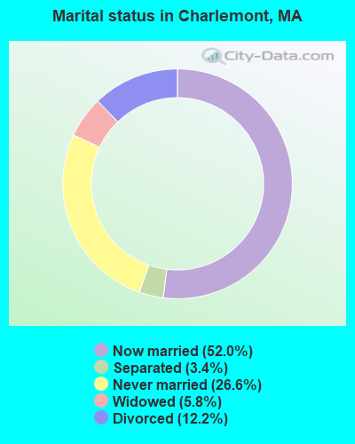
- Never married: 26.6%
- Now married: 52.0%
- Separated: 3.4%
- Widowed: 5.8%
- Divorced: 12.2%
For population 25 years and over in Charlemont:
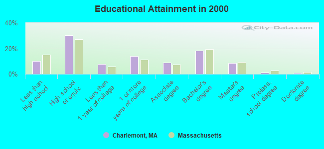
- High school or higher: 89.9%
- Bachelor's degree or higher: 29.0%
- Graduate or professional degree: 10.6%
- Unemployed: 5.3%
- Mean travel time to work (commute): 30.1 minutes
| Here: | 10.2 |
| Massachusetts average: | 13.1 |


Graphs represent county-level data. Detailed 2008 Election Results
Religion statistics for Charlemont, MA (based on Franklin County data)


| Religion | Adherents | Congregations |
|---|---|---|
| Catholic | 16,509 | 15 |
| Mainline Protestant | 4,617 | 38 |
| Evangelical Protestant | 2,079 | 20 |
| Other | 1,580 | 21 |
| None | 46,587 | - |
Food Environment Statistics:
| Franklin County: | 3.63 / 10,000 pop. |
| State: | 1.98 / 10,000 pop. |
| Franklin County: | 0.14 / 10,000 pop. |
| State: | 0.05 / 10,000 pop. |
| Franklin County: | 1.67 / 10,000 pop. |
| Massachusetts: | 2.22 / 10,000 pop. |
| Franklin County: | 3.21 / 10,000 pop. |
| State: | 1.77 / 10,000 pop. |
| Franklin County: | 8.10 / 10,000 pop. |
| Massachusetts: | 8.76 / 10,000 pop. |
| Franklin County: | 7.5% |
| Massachusetts: | 8.1% |
| Here: | 22.2% |
| Massachusetts: | 22.5% |
| Here: | 15.1% |
| State: | 16.5% |
Strongest AM radio stations in Charlemont:
- WNNZ (640 AM; 50 kW; WESTFIELD, MA; Owner: CLEAR CHANNEL BROADCASTING LICENSES, INC.)
- WIZZ (1520 AM; daytime; 10 kW; GREENFIELD, MA; Owner: P. & M. RADIO, LLC)
- WCRN (830 AM; 50 kW; WORCESTER, MA; Owner: CARTER BROADCASTING CORPORATION)
- WGY (810 AM; 50 kW; SCHENECTADY, NY; Owner: CLEAR CHANNEL BROADCASTING LICENSES, INC.)
- WVNE (760 AM; daytime; 25 kW; LEICESTER, MA; Owner: BLOUNT MASSCOM, INC.)
- WTIC (1080 AM; 50 kW; HARTFORD, CT; Owner: INFINITY RADIO OPERATIONS INC.)
- WPTR (1540 AM; 50 kW; ALBANY, NY; Owner: KIMTRON, INC.)
- WRKO (680 AM; 50 kW; BOSTON, MA; Owner: ENTERCOM BOSTON LICENSE, LLC)
- WHYN (560 AM; 5 kW; SPRINGFIELD, MA; Owner: CLEAR CHANNEL BROADCASTING LICENSES, INC.)
- WEEI (850 AM; 50 kW; BOSTON, MA; Owner: ENTERCOM BOSTON LICENSE, LLC)
- WALE (990 AM; 50 kW; GREENVILLE, RI; Owner: NORTH AMERICAN BROADCASTING CO., INC.)
- WKOX (1200 AM; 50 kW; FRAMINGHAM, MA; Owner: CAPSTAR TX LIMITED PARTNERSHIP)
- WUHN (1110 AM; daytime; 5 kW; PITTSFIELD, MA; Owner: WEINER BROADCASTING, INC.)
Strongest FM radio stations in Charlemont:
- WAMC-FM (90.3 FM; ALBANY, NY; Owner: WAMC)
- WPVQ (95.3 FM; GREENFIELD, MA; Owner: GREAT NORTHERN RADIO, L.L.C.)
- WVAY (100.7 FM; WILMINGTON, VT; Owner: GREAT NORTHERN RADIO, L.L.C.)
- WMNB (100.1 FM; NORTH ADAMS, MA; Owner: BERKSHIRE BROADCASTING CO., INC.)
- WEQX (102.7 FM; MANCHESTER, VT; Owner: NORTHSHIRE COMMUNICATIONS, INC.)
- WJAN (95.1 FM; SUNDERLAND, VT; Owner: 6 JOHNSON ROAD LICENSES, INC.)
- WRSY (101.5 FM; MARLBORO, VT; Owner: GREAT NORTHERN RADIO, L.L.C.)
- WHAI (98.3 FM; GREENFIELD, MA; Owner: SAGA COMMUNICATIONS OF NEW ENGLAND, LLC)
- WRSI (93.9 FM; TURNERS FALLS, MA; Owner: GREAT NORTHERN RADIO, LLC)
- WZEC (97.5 FM; HOOSICK FALLS, NY; Owner: GREAT NORTHERN RADIO, LLC)
- WHYN-FM (93.1 FM; SPRINGFIELD, MA; Owner: CLEAR CHANNEL BROADCASTING LICENSES, INC.)
- WFCR (88.5 FM; AMHERST, MA; Owner: UNIVERSITY OF MASSACHUSETTS)
- WKVT-FM (92.7 FM; BRATTLEBORO, VT; Owner: SAGA COMMUNICATIONS OF NEW ENGLAND, LLC)
- WYRY (104.9 FM; HINSDALE, NH; Owner: TRI-VALLEY BROADCASTING CORPORATION)
- WRNX (100.9 FM; AMHERST, MA; Owner: WESTERN MASSACHUSETTS RADIO COMPANY)
- WHDQ (106.1 FM; CLAREMONT, NH; Owner: GREAT NORTHERN RADIO, L.L.C.)
- WJJR (98.1 FM; RUTLAND, VT; Owner: 6 JOHNSON ROAD LICENSES, INC.)
- WZRT (97.1 FM; RUTLAND, VT; Owner: CAPSTAR TX LIMITED PARTNERSHIP)
- WVPR (89.5 FM; WINDSOR, VT; Owner: VERMONT PUBLIC RADIO)
- WCMK (91.9 FM; PUTNEY, VT; Owner: CHRISTIAN MINISTRIES INC)
TV broadcast stations around Charlemont:
- W35BK (Channel 35; PLAINFIELD, MA; Owner: LYDIA SYLVANE STOCKWELL)
- WYDN (Channel 48; WORCESTER, MA; Owner: EDUCATIONAL PUBLIC TV CORPORATION)
- WCDC-TV (Channel 19; ADAMS, MA; Owner: YOUNG BROADCASTING OF ALBANY, INC.)
- W38DL (Channel 38; ADAMS, ETC., MA; Owner: WNYT-TV, LLC)
- Charlemont, Massachusetts
- Fatal accident count17
- Vehicles involved in fatal accidents28
- Fatal accidents involving drunk persons:5
- Fatalities18
- Persons involved in fatal accidents44
- Pedestrians involved in fatal accidents1
- Massachusetts average
- Fatal accident count8152
- Vehicles involved in fatal accidents11419
- Fatal accidents involving drunk persons2581
- Fatalities8781
- Persons involved in fatal accidents19076
- Pedestrians involved in fatal accidents927
- National Bridge Inventory (NBI) Statistics
- 30Number of bridges
- 266ft / 80.9mTotal length
- $57,884,000Total costs
- 39,234Total average daily traffic
- 3,247Total average daily truck traffic
- 29,864Total future (year 2031) average daily traffic
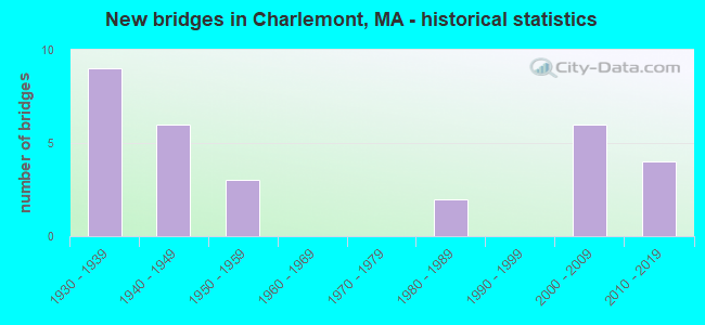
- New bridges - historical statistics
- 91930-1939
- 61940-1949
- 31950-1959
- 21980-1989
- 62000-2009
- 42010-2019
FCC Registered Broadcast Land Mobile Towers:
2- Lat: 42.653611 Lon: -72.929167, Call Sign: WRCL896,
Assigned Frequencies: 851.012 MHz, 851.012 MHz, 851.512 MHz, 851.512 MHz, 852.012 MHz, 852.012 MHz, 852.512 MHz, 852.512 MHz, 853.012 MHz, 853.012 MHz, Grant Date: 11/05/2018, Expiration Date: 11/10/2018, Cancellation Date: 02/16/2019, Certifier: John J Ruggiero, Registrant: Massachusetts State Police, 470 Worcester Road, Framingham, MA 01702, Phone: (508) 820-2222, Email:
- Lat: 42.653611 Lon: -72.929167, Call Sign: WRCL897,
Assigned Frequencies: 151.137 MHz, 154.452 MHz, 158.737 MHz, 159.472 MHz, 453.212 MHz, 453.212 MHz, 453.462 MHz, 453.462 MHz, 453.712 MHz, 453.712 MHz, 453.862 MHz, 453.862 MHz, Grant Date: 11/05/2018, Expiration Date: 11/10/2018, Cancellation Date: 02/16/2019, Certifier: John J Ruggiero, Registrant: Massachusetts State Police, 470 Worcester Road, Framingham, MA 01702, Phone: (508) 820-2222, Email:
FCC Registered Microwave Towers:
3- MT INSTITUTE, Off Labelle Road (Lat: 42.613000 Lon: -72.869000), Type: Tower, Structure height: 15.3 m, Call Sign: WQDJ219,
Assigned Frequencies: 953.950 MHz, Grant Date: 09/08/2005, Expiration Date: 09/08/2015, Cancellation Date: 11/14/2015, Certifier: Russell Sienkiewcz, Registrant: New England Communications Systems, Inc, 15 Industrial Park Place, Middletown, CT 06457, Phone: (860) 632-2678, Fax: (860) 613-0559, Email:
- CHARLEMONT, Off Of River Road (Lat: 42.598944 Lon: -72.858139), Type: Tower, Structure height: 36.6 m, Call Sign: WQJB303,
Assigned Frequencies: 10556.2 MHz, Grant Date: 05/05/2018, Expiration Date: 07/14/2028, Certifier: Linda Dunlavy, Registrant: Franklin Regional Council Of Governments, 12 Olive St Ste 2, Greenfield, MA 01301-3351, Phone: (413) 774-3167, Fax: (413) 774-3169, Email:
- BERKSHIRE EA, E Mountain Rd, 1 Mile S Of (Lat: 42.613917 Lon: -72.870028), Type: Mast, Structure height: 36.6 m, Call Sign: WQNC833,
Assigned Frequencies: 10895.0 MHz, 11015.0 MHz, 10578.1 MHz, Grant Date: 09/29/2020, Expiration Date: 12/21/2030, Certifier: Charles B Sutherland, Registrant: Massachusetts, Commonwealth Of, 470 Worcester Rd, Framingham, MA 01702, Phone: (508) 820-2264, Email:
FCC Registered Amateur Radio Licenses:
12 (See the full list of FCC Registered Amateur Radio Licenses in Charlemont)2002 - 2018 National Fire Incident Reporting System (NFIRS) incidents
- Fire incident types reported to NFIRS in Charlemont, MA
- 12653.4%Structure Fires
- 7330.9%Outside Fires
- 208.5%Other
- 177.2%Mobile Property/Vehicle Fires
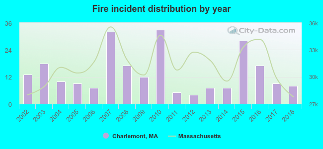 According to the data from the years 2002 - 2018 the average number of fires per year is 14. The highest number of reported fire incidents - 33 took place in 2010, and the least - 4 in 2012. The data has a declining trend.
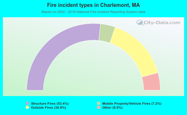 When looking into fire subcategories, the most incidents belonged to: Structure Fires (53.4%), and Outside Fires (30.9%).
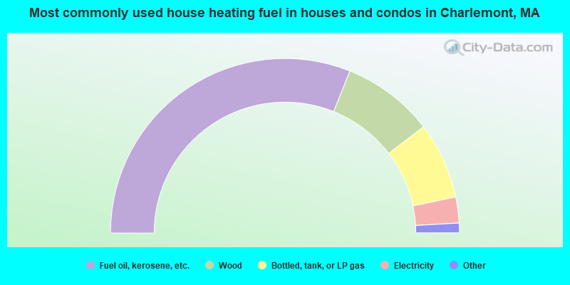
- 62.1%Fuel oil, kerosene, etc.
- 17.0%Wood
- 14.2%Bottled, tank, or LP gas
- 4.8%Electricity
- 0.8%Other fuel
- 0.5%Utility gas
- 0.5%Coal or coke
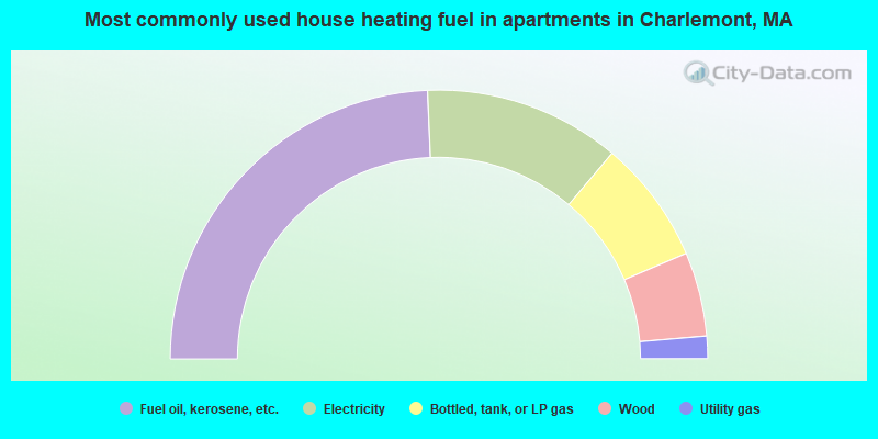
- 48.6%Fuel oil, kerosene, etc.
- 23.6%Electricity
- 14.9%Bottled, tank, or LP gas
- 10.1%Wood
- 2.7%Utility gas
Charlemont compared to Massachusetts state average:
- Median house value below state average.
- Unemployed percentage below state average.
- Black race population percentage significantly below state average.
- Hispanic race population percentage significantly below state average.
- Median age above state average.
- Foreign-born population percentage significantly below state average.
- Length of stay since moving in significantly above state average.
- Number of rooms per house significantly below state average.
- House age significantly below state average.
Charlemont on our top lists:
- #56 on the list of "Top 101 cities with the largest percentage of people in other nonhousehold living situations (population 1,000+)"
- #81 on the list of "Top 101 cities with the largest percentage of people in agriculture workers' dormitories on farms (population 1,000+)"
- #21 on the list of "Top 101 counties with the highest percentage of residents that drank alcohol in the past 30 days"
- #65 on the list of "Top 101 counties with the lowest average weight of females"
- #84 on the list of "Top 101 counties with the lowest surface withdrawal of fresh water for public supply (pop. 50,000+)"
- #88 on the list of "Top 101 counties with the best general health status score of residents (1-5), 3 years of data"
- #92 on the list of "Top 101 counties with the highest percentage of residents that smoked 100+ cigarettes in their lives"

|
Total of 3 patent applications in 2008-2024.