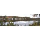
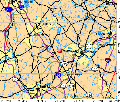
Salem, New Hampshire
Submit your own pictures of this town and show them to the world
- OSM Map
- General Map
- Google Map
- MSN Map
Population change since 2000: +2.4%
 |
| Males: 14,253 | |
| Females: 14,523 |
| Median resident age: | 43.2 years |
| New Hampshire median age: | 43.9 years |
Zip codes: 03079.
| Salem: | $107,331 |
| NH: | $89,992 |
Estimated per capita income in 2022: $57,446 (it was $26,170 in 2000)
Salem town income, earnings, and wages data
Estimated median house or condo value in 2022: $494,700 (it was $161,900 in 2000)
| Salem: | $494,700 |
| NH: | $384,700 |
Mean prices in 2022: all housing units: $614,227; detached houses: $665,470; townhouses or other attached units: $408,866; in 2-unit structures: $730,084; in 3-to-4-unit structures: over $1,000,000; in 5-or-more-unit structures: $329,099; mobile homes: $126,160
Detailed information about poverty and poor residents in Salem, NH


Compare current foreclosures near Salem, NH:
| Photo | Address | Area | Beds / Baths | Price | Details |
|---|---|---|---|---|---|

|
#1
Maclarnon Rd
Salem, NH 03079
|
2,020 sq. feet
|
1 baths 3 beds |
show details | |

|
#2
Webster St
Salem, NH 03079
|
1,912 sq. feet
|
2 baths 3 beds |
show details | |

|
#3
Samoset Dr
Salem, NH 03079
|
4,816 sq. feet
|
3 baths 3 beds |
show details | |

|
#4
Alexander Ave
Salem, NH 03079
|
1,149 sq. feet
|
1 baths 3 beds |
show details | |

|
#5
Muse Ter
Salem, NH 03079
|
1,024 sq. feet
|
1 baths 3 beds |
show details | |

|
#6
Hamilton Ln
Salem, NH 03079
|
2,818 sq. feet
|
2 baths 4 beds |
show details | |

|
#7
Cluff Crossing Rd
Salem, NH 03079
|
1,120 sq. feet
|
2 baths 2 beds |
show details | |

|
#8
Parkview Ave
Salem, NH 03079
|
1,812 sq. feet
|
1 baths 3 beds |
show details | |

|
#9
Pleasant St
Salem, NH 03079
|
- sq. feet
|
- baths - beds |
show details | |

|
#10
Cedar St # A
Haverhill, MA 01830
|
1,134 sq. feet
|
2 baths 2 beds |
$209,300
|
show details |
| Photo | Address | Area | Beds / Baths | Price | Details |
|---|---|---|---|---|---|

|
#11
Shore Dr
Hampstead, NH 03841
|
787 sq. feet
|
1 baths 2 beds |
$529,900
|
show details |

|
#12
Willow Creek Dr # 42
Hudson, NH 03051
|
1,120 sq. feet
|
1 baths 2 beds |
show details | |

|
#13
Thornton St
Lawrence, MA 01841
|
912 sq. feet
|
1 baths 2 beds |
show details | |

|
#14
S Mammoth Rd
Manchester, NH 03109
|
1,555 sq. feet
|
2 baths 4 beds |
show details | |

|
#15
3rd Ave
North Chelmsford, MA 01863
|
- sq. feet
|
1 baths 2 beds |
show details | |

|
#16
Boston Rd
Chelmsford, MA 01824
|
1,392 sq. feet
|
1 baths 3 beds |
show details | |

|
#17
Salem St
North Andover, MA 01845
|
1,572 sq. feet
|
1 baths 2 beds |
show details | |

|
#18
High St
Derry, NH 03038
|
2,005 sq. feet
|
3 baths 4 beds |
show details | |

|
#19
Mill River Ln
Rowley, MA 01969
|
2,705 sq. feet
|
2 baths 4 beds |
show details | |

|
#20
Byron St
Haverhill, MA 01835
|
2,446 sq. feet
|
2 baths 4 beds |
show details |
| Photo | Address | Area | Beds / Baths | Price | Details |
|---|---|---|---|---|---|

|
#21
Landsdown Dr
Nashua, NH 03062
|
1,860 sq. feet
|
2 baths 3 beds |
show details | |

|
#22
Emily Rd
Tewksbury, MA 01876
|
1,600 sq. feet
|
1 baths 3 beds |
show details | |

|
#23
S Broadway
Lawrence, MA 01843
|
5,706 sq. feet
|
2 baths 6 beds |
show details | |

|
#24
Williamine Dr
Newton, NH 03858
|
2,295 sq. feet
|
1 baths 3 beds |
show details | |

|
#25
Cheney Dr
Hudson, NH 03051
|
1,685 sq. feet
|
2 baths 3 beds |
show details | |

|
#26
Salem Rd
Billerica, MA 01821
|
1,428 sq. feet
|
1 baths 4 beds |
show details | |

|
#27
Brook St
Derry, NH 03038
|
1,476 sq. feet
|
2 baths 4 beds |
show details | |

|
#28
Lyons St
Lowell, MA 01852
|
1,314 sq. feet
|
1 baths 2 beds |
show details | |

|
#29
Weare St
Lawrence, MA 01843
|
1,222 sq. feet
|
1 baths 3 beds |
show details | |

|
#30
Pine Ridge Rd
Windham, NH 03087
|
1,746 sq. feet
|
2 baths 4 beds |
show details |
| Photo | Address | Area | Beds / Baths | Price | Details |
|---|---|---|---|---|---|

|
#31
Pawtucket Boulevard Unit # 7, Bldg 6 Camelot Court Condominium No. 1)
Lowell, MA Array
|
883 sq. feet
|
1 baths 2 beds |
show details | |

|
#32
W Parish Ln # A
Boxford, MA 01921
|
2,638 sq. feet
|
2 baths 3 beds |
show details | |

|
#33
Scenic Dr
Derry, NH 03038
|
1,692 sq. feet
|
1 baths 2 beds |
show details | |

|
#34
Stevens St
Lowell, MA 01851
|
2,900 sq. feet
|
2 baths 4 beds |
show details | |

|
#35
Robbins Ave Apt 1
Dracut, MA 01826
|
1,044 sq. feet
|
1 baths 2 beds |
show details | |

|
#36
Thissell Ave Apt 105
Dracut, MA 01826
|
1,044 sq. feet
|
1 baths 2 beds |
show details | |

|
#37
Carlisle St
Lowell, MA 01852
|
1,913 sq. feet
|
2 baths 5 beds |
show details | |

|
#38
Vermont Ave # 1
Dracut, MA 01826
|
2,070 sq. feet
|
2 baths 4 beds |
show details | |

|
#39
Brown Ave
Manchester, NH 03103
|
1,296 sq. feet
|
1 baths 4 beds |
show details | |

|
#40
Arlington St
Tewksbury, MA 01876
|
984 sq. feet
|
1 baths 3 beds |
show details |
| Photo | Address | Area | Beds / Baths | Price | Details |
|---|---|---|---|---|---|

|
#41
Maple St
Amesbury, MA 01913
|
2,186 sq. feet
|
2 baths 4 beds |
show details | |

|
#42
Cannongate Rd Apt 42
Tyngsboro, MA 01879
|
1,436 sq. feet
|
1 baths 2 beds |
show details | |

|
#43
Madeline Rd
Tewksbury, MA 01876
|
1,152 sq. feet
|
1 baths 3 beds |
show details | |

|
#44
Elysian Dr
Andover, MA 01810
|
2,078 sq. feet
|
1 baths 4 beds |
show details | |

|
#45
Shawsheen St
Tewksbury, MA 01876
|
1,918 sq. feet
|
2 baths 4 beds |
show details | |

|
#46
Chestnut St
North Andover, MA 01845
|
2,516 sq. feet
|
3 baths 4 beds |
show details | |

|
#47
Fiddlehead Ln
Chester, NH 03036
|
2,682 sq. feet
|
2 baths 4 beds |
show details | |

|
#48
Merrill Ave
Amesbury, MA 01913
|
1,467 sq. feet
|
1 baths 3 beds |
show details | |

|
#49
Pawtucket Blvd Unit 24
Lowell, MA 01854
|
929 sq. feet
|
1 baths 2 beds |
show details | |

|
Check over 1 million property listings on Foreclosure.com!
|
browse all offers | |||

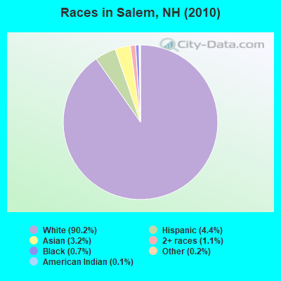
- 25,95890.2%White alone
- 1,2704.4%Hispanic
- 9253.2%Asian alone
- 3111.1%Two or more races
- 2120.7%Black alone
- 560.2%Other race alone
- 360.1%American Indian alone
- 80.03%Native Hawaiian and Other
Pacific Islander alone
Races in Salem detailed stats: ancestries, foreign born residents, place of birth
According to our research of New Hampshire and other state lists, there were 35 registered sex offenders living in Salem, New Hampshire as of May 03, 2024.
The ratio of all residents to sex offenders in Salem is 822 to 1.
The ratio of registered sex offenders to all residents in this city is lower than the state average.
Type |
2010 |
2011 |
2012 |
2013 |
2014 |
2015 |
2016 |
2017 |
2018 |
2019 |
2020 |
2021 |
2022 |
|---|---|---|---|---|---|---|---|---|---|---|---|---|---|
| Murders (per 100,000) | 0 (0.0) | 0 (0.0) | 3 (10.4) | 0 (0.0) | 0 (0.0) | 0 (0.0) | 0 (0.0) | 0 (0.0) | 0 (0.0) | 0 (0.0) | 0 (0.0) | 0 (0.0) | 0 (0.0) |
| Rapes (per 100,000) | 5 (17.4) | 5 (17.4) | 6 (20.7) | 4 (13.8) | 6 (20.7) | 10 (34.4) | 3 (10.4) | 9 (31.0) | 6 (20.5) | 5 (16.9) | 6 (20.0) | 7 (22.4) | 9 (29.3) |
| Robberies (per 100,000) | 8 (27.8) | 14 (48.6) | 12 (41.5) | 14 (48.5) | 21 (72.6) | 24 (82.5) | 19 (65.6) | 17 (58.6) | 13 (44.4) | 13 (43.9) | 10 (33.4) | 2 (6.4) | 11 (35.8) |
| Assaults (per 100,000) | 24 (83.4) | 15 (52.1) | 18 (62.2) | 30 (103.9) | 29 (100.3) | 24 (82.5) | 19 (65.6) | 15 (51.7) | 11 (37.5) | 7 (23.6) | 5 (16.7) | 7 (22.4) | 9 (29.3) |
| Burglaries (per 100,000) | 73 (253.7) | 76 (263.8) | 88 (304.2) | 65 (225.1) | 50 (172.9) | 50 (171.9) | 45 (155.4) | 25 (86.2) | 20 (68.3) | 25 (84.4) | 14 (46.8) | 16 (51.2) | 16 (52.1) |
| Thefts (per 100,000) | 753 (2,617) | 751 (2,606) | 773 (2,672) | 766 (2,652) | 675 (2,334) | 617 (2,121) | 541 (1,869) | 410 (1,413) | 449 (1,533) | 404 (1,364) | 298 (995.2) | 301 (963.8) | 400 (1,302) |
| Auto thefts (per 100,000) | 51 (177.2) | 57 (197.8) | 43 (148.7) | 35 (121.2) | 25 (86.4) | 35 (120.3) | 23 (79.5) | 11 (37.9) | 12 (41.0) | 20 (67.5) | 19 (63.5) | 21 (67.2) | 20 (65.1) |
| Arson (per 100,000) | 12 (41.7) | 5 (17.4) | 10 (34.6) | 2 (6.9) | 2 (6.9) | 3 (10.3) | 2 (6.9) | 3 (10.3) | 0 (0.0) | 2 (6.8) | 2 (6.7) | 0 (0.0) | 1 (3.3) |
| City-Data.com crime index | 175.5 | 177.4 | 202.3 | 177.9 | 170.8 | 175.3 | 133.1 | 118.3 | 106.6 | 97.3 | 77.5 | 71.9 | 101.0 |
The City-Data.com crime index weighs serious crimes and violent crimes more heavily. Higher means more crime, U.S. average is 246.1. It adjusts for the number of visitors and daily workers commuting into cities.
Crime rate in Salem detailed stats: murders, rapes, robberies, assaults, burglaries, thefts, arson
Full-time law enforcement employees in 2021, including police officers: 79 (64 officers - 62 male; 2 female).
| Officers per 1,000 residents here: | 2.05 |
| New Hampshire average: | 2.14 |
 Recent articles from our blog. Our writers, many of them Ph.D. graduates or candidates, create easy-to-read articles on a wide variety of topics.

 | Move to NH? Schools? Hockey? Please help! (50 replies) |
| Salem vs Windham (8 replies) |
| Breweries and restaurants with outdoor heat lamp seating - southern NH (3 replies) |
| Have family in Derry New Hampshire and was curious on hotels attractions (7 replies) |
| Move to Hollis vs. Windham (6 replies) |
| Places to visit October (7 replies) |
Latest news from Salem, NH collected exclusively by city-data.com from local newspapers, TV, and radio stations
Ancestries: Irish (24.0%), Italian (20.1%), English (16.1%), French (15.0%), French Canadian (8.3%), German (7.4%).
Current Local Time: EST time zone
Incorporated in 1750
Elevation: 131 feet
Land area: 24.7 square miles.
Population density: 1,165 people per square mile (low).
1,803 residents are foreign born (2.4% Asia, 2.1% Europe, 1.1% North America, 0.9% Latin America).
| This town: | 6.4% |
| New Hampshire: | 4.4% |
| Salem town: | 1.8% ($2,986) |
| New Hampshire: | 2.3% ($2,946) |
Nearest city with pop. 50,000+: Haverhill, MA  (6.6 miles , pop. 58,969).
Nearest city with pop. 200,000+: Boston, MA (33.2 miles , pop. 589,141).
Nearest city with pop. 1,000,000+: Bronx, NY (192.1 miles , pop. 1,332,650).
Nearest cities:
), Latitude: 42.79 N, Longitude: 71.21 W
Area code: 603

Salem tourist attractions:
Salem, New Hampshire accommodation & food services, waste management - Economy and Business Data
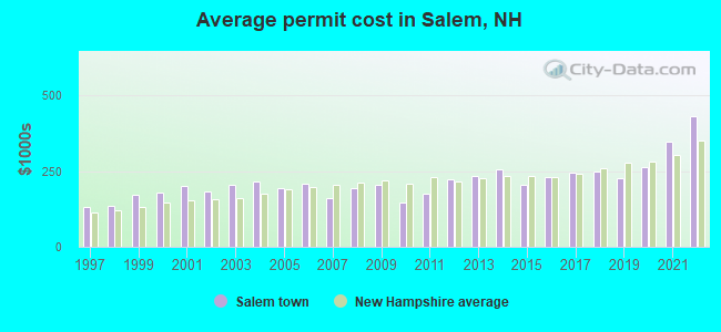
Single-family new house construction building permits:
- 2022: 48 buildings, average cost: $432,700
- 2021: 62 buildings, average cost: $347,100
- 2020: 70 buildings, average cost: $262,700
- 2019: 93 buildings, average cost: $226,100
- 2018: 73 buildings, average cost: $250,100
- 2017: 66 buildings, average cost: $243,900
- 2016: 44 buildings, average cost: $228,800
- 2015: 33 buildings, average cost: $205,400
- 2014: 41 buildings, average cost: $258,000
- 2013: 34 buildings, average cost: $233,900
- 2012: 22 buildings, average cost: $222,900
- 2011: 15 buildings, average cost: $177,000
- 2010: 14 buildings, average cost: $148,400
- 2009: 10 buildings, average cost: $205,300
- 2008: 12 buildings, average cost: $194,600
- 2007: 32 buildings, average cost: $160,900
- 2006: 49 buildings, average cost: $208,000
- 2005: 74 buildings, average cost: $192,600
- 2004: 86 buildings, average cost: $216,800
- 2003: 68 buildings, average cost: $205,600
- 2002: 119 buildings, average cost: $182,500
- 2001: 126 buildings, average cost: $200,600
- 2000: 120 buildings, average cost: $177,800
- 1999: 192 buildings, average cost: $171,500
- 1998: 141 buildings, average cost: $133,600
- 1997: 83 buildings, average cost: $130,400
| Here: | 3.1% |
| New Hampshire: | 2.5% |
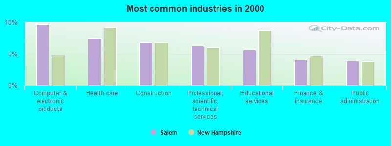
- Computer & electronic products (9.7%)
- Health care (7.4%)
- Construction (6.8%)
- Professional, scientific, technical services (6.3%)
- Educational services (5.6%)
- Finance & insurance (4.0%)
- Public administration (3.9%)
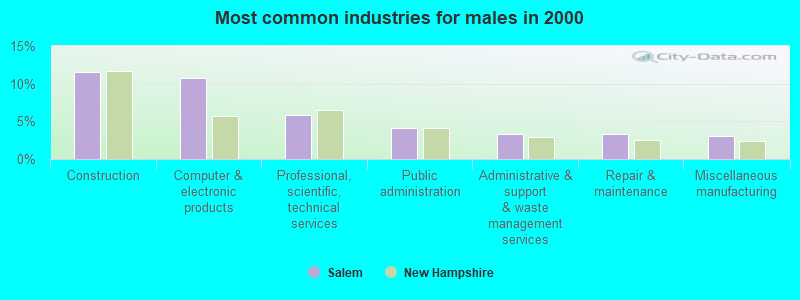
- Construction (11.5%)
- Computer & electronic products (10.7%)
- Professional, scientific, technical services (5.9%)
- Public administration (4.1%)
- Administrative & support & waste management services (3.4%)
- Repair & maintenance (3.3%)
- Miscellaneous manufacturing (3.1%)
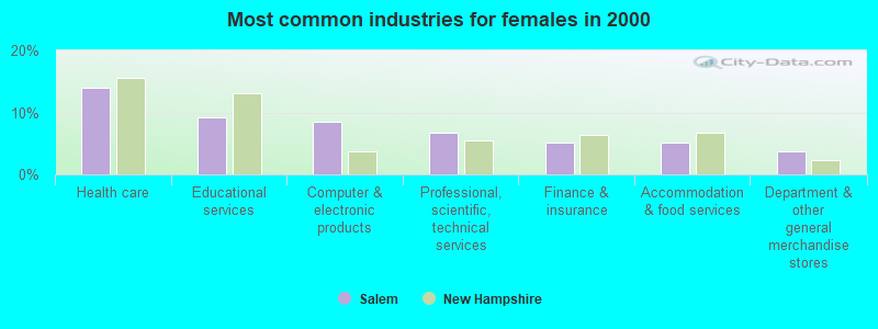
- Health care (13.9%)
- Educational services (9.2%)
- Computer & electronic products (8.4%)
- Professional, scientific, technical services (6.8%)
- Finance & insurance (5.2%)
- Accommodation & food services (5.1%)
- Department & other general merchandise stores (3.8%)
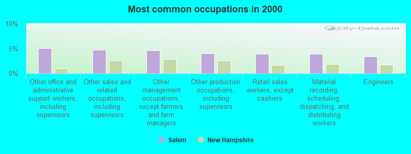
- Other office and administrative support workers, including supervisors (5.1%)
- Other sales and related occupations, including supervisors (4.7%)
- Other management occupations, except farmers and farm managers (4.6%)
- Other production occupations, including supervisors (4.0%)
- Retail sales workers, except cashiers (3.9%)
- Material recording, scheduling, dispatching, and distributing workers (3.9%)
- Engineers (3.4%)
- Other sales and related occupations, including supervisors (6.1%)
- Material recording, scheduling, dispatching, and distributing workers (5.4%)
- Other management occupations, except farmers and farm managers (4.9%)
- Engineers (4.8%)
- Driver/sales workers and truck drivers (4.5%)
- Other production occupations, including supervisors (4.4%)
- Sales representatives, services, wholesale and manufacturing (4.2%)
- Other office and administrative support workers, including supervisors (8.4%)
- Secretaries and administrative assistants (5.8%)
- Retail sales workers, except cashiers (5.0%)
- Other management occupations, except farmers and farm managers (4.2%)
- Registered nurses (3.7%)
- Other production occupations, including supervisors (3.6%)
- Preschool, kindergarten, elementary, and middle school teachers (3.2%)
Average climate in Salem, New Hampshire
Based on data reported by over 4,000 weather stations


(lower is better)
Air Quality Index (AQI) level in 2022 was 64.9. This is about average.
| City: | 64.9 |
| U.S.: | 72.6 |
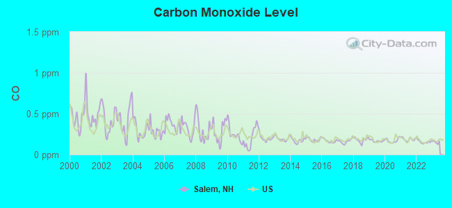
Carbon Monoxide (CO) [ppm] level in 2022 was 0.157. This is significantly better than average. Closest monitor was 9.8 miles away from the city center.
| City: | 0.157 |
| U.S.: | 0.251 |

Nitrogen Dioxide (NO2) [ppb] level in 2022 was 6.31. This is worse than average. Closest monitor was 3.1 miles away from the city center.
| City: | 6.31 |
| U.S.: | 5.11 |

Sulfur Dioxide (SO2) [ppb] level in 2022 was 0.338. This is significantly better than average. Closest monitor was 3.1 miles away from the city center.
| City: | 0.338 |
| U.S.: | 1.515 |
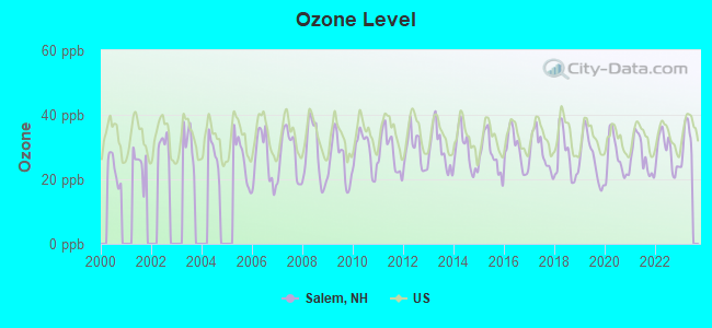
Ozone [ppb] level in 2022 was 28.4. This is about average. Closest monitor was 5.8 miles away from the city center.
| City: | 28.4 |
| U.S.: | 33.3 |
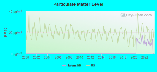
Particulate Matter (PM10) [µg/m3] level in 2022 was 10.6. This is significantly better than average. Closest monitor was 6.7 miles away from the city center.
| City: | 10.6 |
| U.S.: | 19.2 |

Particulate Matter (PM2.5) [µg/m3] level in 2022 was 6.53. This is better than average. Closest monitor was 5.8 miles away from the city center.
| City: | 6.53 |
| U.S.: | 8.11 |
Tornado activity:
Salem-area historical tornado activity is slightly above New Hampshire state average. It is 39% smaller than the overall U.S. average.
On 9/29/1974, a category F3 (max. wind speeds 158-206 mph) tornado 11.9 miles away from the Salem town center injured one person and caused between $50,000 and $500,000 in damages.
On 6/9/1953, a category F4 (max. wind speeds 207-260 mph) tornado 37.5 miles away from the town center killed 90 people and injured 1228 people and caused between $50,000,000 and $500,000,000 in damages.
Earthquake activity:
Salem-area historical earthquake activity is significantly above New Hampshire state average. It is 72% smaller than the overall U.S. average.On 4/20/2002 at 10:50:47, a magnitude 5.3 (5.3 ML, Depth: 3.0 mi, Class: Moderate, Intensity: VI - VII) earthquake occurred 172.1 miles away from Salem center
On 10/7/1983 at 10:18:46, a magnitude 5.3 (5.1 MB, 5.3 LG, 5.1 ML) earthquake occurred 176.6 miles away from the city center
On 1/19/1982 at 00:14:42, a magnitude 4.7 (4.5 MB, 4.7 MD, 4.5 LG, Class: Light, Intensity: IV - V) earthquake occurred 52.7 miles away from the city center
On 10/16/2012 at 23:12:25, a magnitude 4.7 (4.7 ML, Depth: 10.0 mi) earthquake occurred 62.4 miles away from Salem center
On 4/20/2002 at 10:50:47, a magnitude 5.2 (5.2 MB, 4.2 MS, 5.2 MW, 5.0 MW) earthquake occurred 171.6 miles away from Salem center
On 8/22/1992 at 12:20:32, a magnitude 4.8 (4.8 MB, 3.8 MS, 4.7 LG, Depth: 6.2 mi) earthquake occurred 259.2 miles away from the city center
Magnitude types: regional Lg-wave magnitude (LG), body-wave magnitude (MB), duration magnitude (MD), local magnitude (ML), surface-wave magnitude (MS), moment magnitude (MW)
Natural disasters:
The number of natural disasters in Rockingham County (26) is a lot greater than the US average (15).Major Disasters (Presidential) Declared: 17
Emergencies Declared: 9
Causes of natural disasters: Storms: 12, Floods: 9, Winter Storms: 5, Hurricanes: 4, Snowstorms: 4, Snows: 2, Winds: 2, Blizzard: 1, Snowfall: 1, Tornado: 1 (Note: some incidents may be assigned to more than one category).

Main business address for: OMTOOL LTD (SERVICES-PREPACKAGED SOFTWARE), STOCKERYALE INC (OPTICAL INSTRUMENTS & LENSES), STANDEX INTERNATIONAL CORP/DE/ (REFRIGERATION & SERVICE INDUSTRY MACHINERY).
Hospitals and medical centers in Salem:
Heliports located in Salem:
Operable nuclear power plant near Salem:
- 20 miles: Seabrook in Seabrook, NH.
College/University in Salem:
Colleges/universities with over 2000 students nearest to Salem:
- Northern Essex Community College (about 9 miles; Haverhill, MA; Full-time enrollment: 4,737)
- Merrimack College (about 10 miles; North Andover, MA; FT enrollment: 2,734)
- University of Massachusetts-Lowell (about 12 miles; Lowell, MA; FT enrollment: 12,341)
- Mount Washington College (about 18 miles; Manchester, NH; FT enrollment: 2,187)
- North Shore Community College (about 19 miles; Danvers, MA; FT enrollment: 5,195)
- Middlesex Community College (about 19 miles; Bedford, MA; FT enrollment: 6,040)
- Saint Anselm College (about 21 miles; Manchester, NH; FT enrollment: 2,059)
Public high school in Salem:
- SALEM HIGH SCHOOL (Students: 2,276, Location: 44 GEREMONTY DR., Grades: 9-12)
Public elementary/middle schools in Salem:
- WOODBURY SCHOOL (Students: 1,167, Location: 206 MAIN ST., Grades: 6-8)
- WILLIAM T. BARRON ELEMENTARY SCHOOL (Students: 391, Location: 55 BUTLER ST., Grades: KG-5)
- NORTH SALEM ELEMENTARY SCHOOL (Students: 369, Location: 140 ZION HILL RD., Grades: KG-5)
- MARY A. FISK ELEMENTARY SCHOOL (Students: 351, Location: 14 MAIN ST., Grades: PK-5)
- WILLIAM E. LANCASTER SCHOOL (Students: 267, Location: 54 MILLVILLE ST., Grades: KG-5)
- DR. L. F. SOULE SCHOOL (Students: 228, Location: 173 SOUTH POLICY ST., Grades: KG-5)
- WALTER F. HAIGH SCHOOL (Students: 206, Location: 24 SCHOOL ST., Grades: 1-5)
- THE BIRCHES ACADEMY OF ACADEMICS - ART A PUBLIC CH (Location: 419 SOUTH BROADWAY 2ND FLOOR, Grades: 1-8, Charter school)
Private elementary/middle schools in Salem:
- ST JOSEPH REGIONAL CATHOLIC SCHOOL (Students: 179, Location: 40 MAIN ST, Grades: PK-8)
- SALEM CHRISTIAN SCHOOL (Students: 97, Location: 101 SCHOOL ST, Grades: PK-8)
Points of interest:
Notable locations in Salem: Mystery Hill Historic Site (A), Town of Salem Fire Department Station 3 South Salem (B), Town of Salem Fire Department Station 2 North Salem (C), Town of Salem Fire Department Station 1 Headquarters (D), Kelley Library (E), Salem Town Hall (F), Greater Salem Chamber of Commerce (G), Rockingham Park Ambulance (H), Canobie Lake Park Emergency Medical Services (I). Display/hide their locations on the map
Shopping Centers: Salem Plaza Shopping Center (1), Nettles Mall (2), Rockingham Mall Shopping Center (3), The Mall at Rockingham Park Shopping Center (4). Display/hide their locations on the map
Main business address in Salem include: OMTOOL LTD (A), STOCKERYALE INC (B), STANDEX INTERNATIONAL CORP/DE/ (C). Display/hide their locations on the map
Churches in Salem include: Saint Josephs Parish Church (A), Granite State Baptist Church (B), Saint Davids Episcopal Church (C), North Salem United Methodist Church (D), Ararat Armenian Congregational Church (E), Mary Queen of Peace Church (F), Pleasant Street United Methodist Church (G), First Congregational Church of Salem (H), First Baptist Church (I). Display/hide their locations on the map
Cemeteries: Pine Grove Cemetery (1), Mount Pleasant Cemetery (2). Display/hide their locations on the map
Lakes and reservoirs: Captain Pond (A), Townsend Pond (B), World End Pond (C), Arlington Mill Reservoir (D), Millville Lake (E), Taylors Reservoir (F), Taylor Reservoir (G), Arlington Mill Reservoir (H). Display/hide their locations on the map
Streams, rivers, and creeks: Providence Hill Brook (A), Widow Harris Brook (B), Porcupine Brook (C), Policy Brook (D), Hittytity Brook (E), Flatrock Brook (F), Captain Pond Brook (G). Display/hide their locations on the map
Parks in Salem include: Canobie Lake Park (1), Rockingham Park (2). Display/hide their locations on the map
Tourist attractions: Petsmart - Grooming (Cultural Attractions- Events- & Facilities; 290 South Broadway) (1), Rockingham Carousel (Arcades & Amusements; 1 Mall Rd) (2). Display/hide their approximate locations on the map
Hotels: Holiday Inn Salem- New Hampshire (1 Keewaydin Dr) (1), Red Roof Inns - Salem (15 Red Roof Lane) (2), Fairfield Inn by Marriott (8 Keewaydin Drive) (3), Four Seasons Sunrooms (13 Delaware Drive # 15) (4). Display/hide their approximate locations on the map
Courts: Rockingham County of Family Court (35 Geremonty Drive) (1), Wm's Court (202 Main Street) (2), Salem District Court (35 Geremonty Drive) (3). Display/hide their approximate locations on the map
Birthplace of: D.J. Bettencourt - Member of the New Hampshire House of Representatives, Danny Sheehan - Boxer, George Phineas Gordon - Inventor, Pete Clifford - Football player.
Drinking water stations with addresses in Salem and their reported violations in the past:
OAKRIDGE CONDOS (Population served: 250, Groundwater):Past health violations:SCOTTISH HIGHLAND GOLF COURSE (Address: 79 BRADY AVE , Population served: 200, Groundwater):Past monitoring violations:
- MCL, Monthly (TCR) - In DEC-2006, Contaminant: Coliform. Follow-up actions: St Public Notif requested (DEC-15-2006), St Violation/Reminder Notice (DEC-15-2006), St Public Notif received (JAN-09-2007), St Compliance achieved (JUN-30-2007)
- Follow-up Or Routine LCR Tap M/R - In JAN-01-2013, Contaminant: Lead and Copper Rule. Follow-up actions: St Public Notif requested (JUL-23-2013), St Violation/Reminder Notice (JUL-23-2013), St Compliance achieved (OCT-01-2013), St Formal NOV issued (OCT-01-2013), St Public Notif received (OCT-09-2013)
- Lead Consumer Notice - In JAN-01-2013, Contaminant: Lead and Copper Rule. Follow-up actions: St Violation/Reminder Notice (APR-26-2013), St Formal NOV issued (JUL-19-2013), St Compliance achieved (OCT-09-2013)
Past health violations:OLDE COUNTRY VILLAGE TOWNHOUSE (Population served: 130, Groundwater):
- MCL, Monthly (TCR) - Between JUL-2012 and SEP-2012, Contaminant: Coliform. Follow-up actions: St Public Notif requested (AUG-22-2012), St Violation/Reminder Notice (AUG-22-2012), St Public Notif received (AUG-28-2012), St Compliance achieved (JAN-18-2013)
Past health violations:MIDRIDGE CONDOS (Population served: 100, Groundwater):
- OCCT/SOWT Treatment Installation/Demonstration - In OCT-29-2011, Contaminant: Lead and Copper Rule. Follow-up actions: St Public Notif requested (NOV-02-2011), St Violation/Reminder Notice (NOV-02-2011), St Compliance achieved (NOV-21-2011), St Public Notif received (NOV-28-2011)
- OCCT/SOWT Study/Recommendation - In JUN-01-2010, Contaminant: Lead and Copper Rule. Follow-up actions: St Compliance achieved (MAR-29-2010), St Violation/Reminder Notice (JUN-04-2010)
- MCL, Average - Between JAN-2010 and MAR-2010, Contaminant: Combined Uranium. Follow-up actions: St Public Notif requested (MAR-24-2010), St Violation/Reminder Notice (MAR-24-2010), St Public Notif received (JUL-21-2010), St Compliance achieved (OCT-07-2010)
- MCL, Average - Between OCT-2009 and DEC-2009, Contaminant: Combined Uranium. Follow-up actions: St Public Notif requested (FEB-01-2010), St Violation/Reminder Notice (FEB-01-2010), St Public Notif received (JUL-21-2010), St Compliance achieved (OCT-07-2010)
- MCL, Average - Between JUL-2009 and SEP-2009, Contaminant: Combined Uranium. Follow-up actions: St Formal NOV issued (JAN-12-2009), St BCA signed (MAR-04-2009), St Public Notif requested (OCT-12-2009), St Violation/Reminder Notice (OCT-12-2009), St Public Notif received (OCT-27-2009), St Compliance achieved (OCT-07-2010)
- MCL, Average - Between APR-2009 and JUN-2009, Contaminant: Combined Uranium. Follow-up actions: St Formal NOV issued (JAN-12-2009), St BCA signed (MAR-04-2009), St Public Notif requested (JUN-25-2009), St Violation/Reminder Notice (JUN-25-2009), St Public Notif received (AUG-10-2009), St Compliance achieved (OCT-07-2010)
- 3 other older health violations
Past health violations:MELLING GLEN (Population served: 92, Groundwater):
- MCL, Monthly (TCR) - In JUL-2009, Contaminant: Coliform. Follow-up actions: St Violation/Reminder Notice (JUL-15-2009), St Public Notif requested (JUL-15-2009), St Public Notif received (NOV-17-2009), St Compliance achieved (FEB-16-2010)
- MCL, Monthly (TCR) - In JUL-2006, Contaminant: Coliform. Follow-up actions: St Public Notif requested (JUL-18-2006), St Violation/Reminder Notice (JUL-18-2006), St Public Notif received (AUG-02-2006), St Compliance achieved (JAN-31-2007)
Past monitoring violations:MILLVILLE CIRCLE/NORTH (Population served: 57, Groundwater):
- Failure To Address Deficiency - In OCT-02-2013, Contaminant: GROUNDWATER RULE. Follow-up actions: St Public Notif requested (OCT-17-2013), St Violation/Reminder Notice (OCT-17-2013), St Compliance achieved (NOV-26-2013), St Public Notif received (NOV-27-2013)
Past health violations:MILLVILLE CIRCLE/SOUTH (Population served: 48, Groundwater):
- MCL, Monthly (TCR) - In APR-2012, Contaminant: Coliform. Follow-up actions: St Public Notif requested (MAY-07-2012), St Violation/Reminder Notice (MAY-07-2012), St Public Notif received (JUN-04-2012), St Compliance achieved (OCT-29-2012)
Past monitoring violations:PUMP AND CIRCUMSTANCE (Population served: 43, Groundwater):
- Follow-up Or Routine LCR Tap M/R - In JAN-01-2009, Contaminant: Lead and Copper Rule. Follow-up actions: St Public Notif requested (AUG-05-2009), St Violation/Reminder Notice (AUG-05-2009), St Public Notif received (AUG-27-2009), St Compliance achieved (SEP-10-2009)
- 21 regular monitoring violations
Past monitoring violations:
- One routine major monitoring violation
Drinking water stations with addresses in Salem that have no violations reported:
- ACKERMAN RETIREMENT PARK (Population served: 350, Primary Water Source Type: Groundwater)
- WINDHAM PLAZA (Population served: 200, Primary Water Source Type: Groundwater)
- PINE ACRES CONDOS (Population served: 90, Primary Water Source Type: Groundwater)
| This town: | 2.6 people |
| New Hampshire: | 2.5 people |
| This town: | 70.1% |
| Whole state: | 66.3% |
| This town: | 6.7% |
| Whole state: | 8.3% |
Likely homosexual households (counted as self-reported same-sex unmarried-partner households)
- Lesbian couples: 0.5% of all households
- Gay men: 0.3% of all households
| This town: | 4.1% |
| Whole state: | 6.5% |
| This town: | 1.6% |
| Whole state: | 2.8% |
People in group quarters in Salem in 2010:
- 95 people in nursing facilities/skilled-nursing facilities
- 9 people in group homes intended for adults
- 3 people in other noninstitutional facilities
People in group quarters in Salem in 2000:
- 107 people in nursing homes
- 24 people in other group homes
- 8 people in homes for the mentally ill
- 2 people in religious group quarters
Banks with most branches in Salem (2011 data):
- Bank of America, National Association: Salem Branch at 220 North Broadway, branch established on 1993/12/08; Mall At Rockingham Branch at 99 Rockingham Boulevard, branch established on 1997/05/23. Info updated 2009/11/18: Bank assets: $1,451,969.3 mil, Deposits: $1,077,176.8 mil, headquarters in Charlotte, NC, positive income, 5782 total offices, Holding Company: Bank Of America Corporation
- RBS Citizens, National Association: Salem Branch at 45 South Broadway, branch established on 1978/07/27; Salem Shaw's Branch at 92 Cluff Crossing Road, branch established on 1994/09/12. Info updated 2007/09/19: Bank assets: $106,940.6 mil, Deposits: $75,690.2 mil, headquarters in Providence, RI, positive income, 1135 total offices, Holding Company: Uk Financial Investments Limited
- Sovereign Bank, National Association: Salem Branch at 539 S Broadway, branch established on 1978/03/23; Salem/Main Street Branch at 125 Main Street, branch established on 1980/12/13. Info updated 2012/01/31: Bank assets: $78,146.9 mil, Deposits: $48,042.9 mil, headquarters in Wilmington, DE, positive income, Commercial Lending Specialization, 718 total offices, Holding Company: Banco Santander, S.A.
- First Republic Bank: Salem Branch at 130 Main Street, Suite 206a, branch established on 2010/07/01. Info updated 2010/08/03: Bank assets: $27,791.8 mil, Deposits: $22,459.3 mil, headquarters in San Francisco, CA, positive income, Mortgage Lending Specialization, 60 total offices
- TD Bank, National Association: Salem Branch at 155 North Broadway, branch established on 1995/09/28. Info updated 2010/10/04: Bank assets: $188,912.6 mil, Deposits: $153,149.8 mil, headquarters in Wilmington, DE, positive income, 1314 total offices, Holding Company: Toronto-Dominion Bank, The
- Enterprise Bank and Trust Company: Salem Nh Branch at 130 Main Street, branch established on 2004/12/06. Info updated 2006/11/03: Bank assets: $1,488.4 mil, Deposits: $1,333.6 mil, headquarters in Lowell, MA, positive income, Commercial Lending Specialization, 20 total offices, Holding Company: Enterprise Bancorp, Inc.
- Pentucket Bank: Salem Nh Branch at 234 North Broadway, branch established on 2006/12/04. Info updated 2006/11/03: Bank assets: $642.8 mil, Deposits: $550.1 mil, headquarters in Haverhill, MA, positive income, Commercial Lending Specialization, 5 total offices
- Bank of New England: Bank Of New England at 31 Pelham Road, branch established on 1983/06/24. Info updated 2007/06/12: Bank assets: $470.7 mil, Deposits: $405.4 mil, local headquarters, positive income, Commercial Lending Specialization, 9 total offices
- Salem Co-operative Bank: Salem Co-Operative Bank at 3 South Broadway, branch established on 1922/01/01. Info updated 2011/07/21: Bank assets: $397.8 mil, Deposits: $274.4 mil, local headquarters, positive income, Mortgage Lending Specialization, 2 total offices
For population 15 years and over in Salem:
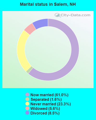
- Never married: 23.3%
- Now married: 61.0%
- Separated: 1.6%
- Widowed: 5.6%
- Divorced: 8.5%
For population 25 years and over in Salem:
- High school or higher: 87.7%
- Bachelor's degree or higher: 25.4%
- Graduate or professional degree: 7.8%
- Unemployed: 3.0%
- Mean travel time to work (commute): 26.4 minutes
| Here: | 10.3 |
| New Hampshire average: | 10.9 |


Graphs represent county-level data. Detailed 2008 Election Results
Religion statistics for Salem, NH (based on Rockingham County data)


| Religion | Adherents | Congregations |
|---|---|---|
| Catholic | 84,697 | 24 |
| Mainline Protestant | 19,072 | 78 |
| Evangelical Protestant | 7,456 | 61 |
| Other | 3,490 | 20 |
| Orthodox | 200 | 1 |
| None | 180,308 | - |
Food Environment Statistics:
| Rockingham County: | 1.59 / 10,000 pop. |
| State: | 2.14 / 10,000 pop. |
| This county: | 0.17 / 10,000 pop. |
| New Hampshire: | 0.15 / 10,000 pop. |
| Rockingham County: | 1.86 / 10,000 pop. |
| New Hampshire: | 1.78 / 10,000 pop. |
| Rockingham County: | 3.31 / 10,000 pop. |
| New Hampshire: | 4.02 / 10,000 pop. |
| This county: | 9.56 / 10,000 pop. |
| New Hampshire: | 9.70 / 10,000 pop. |
| Rockingham County: | 7.6% |
| State: | 7.6% |
| Rockingham County: | 23.3% |
| New Hampshire: | 24.4% |
| Here: | 16.8% |
| New Hampshire: | 15.9% |
7.69% of this county's 2021 resident taxpayers lived in other counties in 2020 ($114,534 average adjusted gross income)
| Here: | 7.69% |
| New Hampshire average: | 7.66% |
0.01% of residents moved from foreign countries ($203 average AGI)
Rockingham County: 0.01% New Hampshire average: 0.01%
Top counties from which taxpayers relocated into this county between 2020 and 2021:
| from Essex County, MA | |
| from Hillsborough County, NH | |
| from Middlesex County, MA |
6.82% of this county's 2020 resident taxpayers moved to other counties in 2021 ($88,778 average adjusted gross income)
| Here: | 6.82% |
| New Hampshire average: | 6.80% |
0.01% of residents moved to foreign countries ($126 average AGI)
Rockingham County: 0.01% New Hampshire average: 0.01%
Top counties to which taxpayers relocated from this county between 2020 and 2021:
| to Hillsborough County, NH | |
| to Strafford County, NH | |
| to Essex County, MA |
| Businesses in Salem, NH | ||||
| Name | Count | Name | Count | |
|---|---|---|---|---|
| 7-Eleven | 1 | Jones New York | 1 | |
| ALDO | 1 | Journeys | 1 | |
| AT&T | 2 | Justice | 1 | |
| Abercrombie & Fitch | 1 | KFC | 1 | |
| Abercrombie Kids | 1 | Kmart | 1 | |
| Advance Auto Parts | 1 | Kohl's | 1 | |
| Aeropostale | 1 | La Quinta | 1 | |
| American Eagle Outfitters | 2 | Lane Bryant | 1 | |
| Apple Store | 1 | LensCrafters | 2 | |
| Ashley Furniture | 1 | Long John Silver's | 1 | |
| AutoZone | 1 | Lowe's | 1 | |
| Bakers | 1 | Macy's | 1 | |
| Banana Republic | 1 | Marshalls | 1 | |
| Barnes & Noble | 1 | MasterBrand Cabinets | 2 | |
| Bath & Body Works | 1 | McDonald's | 1 | |
| Bed Bath & Beyond | 1 | Men's Wearhouse | 2 | |
| Brookstone | 1 | Motherhood Maternity | 3 | |
| Burger King | 2 | New Balance | 2 | |
| CVS | 1 | Nike | 6 | |
| Cache | 1 | Nissan | 1 | |
| Casual Male XL | 1 | Pac Sun | 1 | |
| Charlotte Russe | 1 | Payless | 1 | |
| Chico's | 1 | Penske | 1 | |
| Cinnabon | 1 | PetSmart | 1 | |
| Circle K | 1 | Pier 1 Imports | 1 | |
| DHL | 1 | Pottery Barn | 1 | |
| Dairy Queen | 1 | RadioShack | 2 | |
| Deb | 1 | Red Roof Inn | 1 | |
| Dennys | 1 | Rite Aid | 2 | |
| Domino's Pizza | 1 | Ruby Tuesday | 1 | |
| Dunkin Donuts | 6 | Sears | 3 | |
| Express | 1 | Sephora | 1 | |
| FedEx | 10 | Shaw's | 1 | |
| Finish Line | 1 | Skechers USA | 1 | |
| Foot Locker | 1 | Spencer Gifts | 1 | |
| Ford | 1 | Sprint Nextel | 3 | |
| Forever 21 | 1 | Staples | 1 | |
| Fredericks Of Hollywood | 1 | Subway | 1 | |
| GNC | 1 | T-Mobile | 5 | |
| GameStop | 2 | T.J.Maxx | 1 | |
| Gap | 1 | Taco Bell | 2 | |
| Gymboree | 1 | Talbots | 1 | |
| H&M | 1 | Target | 1 | |
| H&R Block | 2 | Toyota | 1 | |
| Holiday Inn | 1 | Toys"R"Us | 2 | |
| Hollister Co. | 1 | UPS | 12 | |
| Home Depot | 1 | Vans | 3 | |
| Honda | 1 | Verizon Wireless | 3 | |
| Hot Topic | 1 | Victoria's Secret | 1 | |
| Hyundai | 1 | Walgreens | 1 | |
| IHOP | 1 | Walmart | 1 | |
| J. Jill | 1 | Wendy's | 1 | |
| J.Crew | 1 | Wet Seal | 1 | |
| JCPenney | 1 | |||
Strongest AM radio stations in Salem:
- WCEC (1110 AM; daytime; 5 kW; SALEM, NH; Owner: COSTA-EAGLE RADIO VENTURES LTD PARTNERSHIP)
- WDER (1320 AM; 10 kW; DERRY, NH; Owner: BLOUNT COMMUNICATIONS, INC. OF NH)
- WRKO (680 AM; 50 kW; BOSTON, MA; Owner: ENTERCOM BOSTON LICENSE, LLC)
- WEEI (850 AM; 50 kW; BOSTON, MA; Owner: ENTERCOM BOSTON LICENSE, LLC)
- WWZN (1510 AM; 50 kW; BOSTON, MA; Owner: ROSE CITY RADIO CORPORATION)
- WCAP (980 AM; 5 kW; LOWELL, MA; Owner: NORTHEAST RADIO, INC.)
- WKOX (1200 AM; 50 kW; FRAMINGHAM, MA; Owner: CAPSTAR TX LIMITED PARTNERSHIP)
- WBZ (1030 AM; 50 kW; BOSTON, MA; Owner: INFINITY BROADCASTING OPERATIONS, INC.)
- WBIX (1060 AM; 40 kW; NATICK, MA; Owner: LANGER BROADCASTING CORPORATION)
- WCRN (830 AM; 50 kW; WORCESTER, MA; Owner: CARTER BROADCASTING CORPORATION)
- WRCA (1330 AM; 25 kW; WALTHAM, MA; Owner: WRCA LICENSE, LLC)
- WCCM (1490 AM; 1 kW; HAVERHILL, MA; Owner: COSTA-EAGLE RADIO VENTURES LTD P/SHI)
- WGIR (610 AM; 5 kW; MANCHESTER, NH; Owner: CAPSTAR TX LIMITED PARTNERSHIP)
Strongest FM radio stations in Salem:
- WXRV (92.5 FM; HAVERHILL, MA; Owner: BEANPOT BROADCASTING CORP.)
- WKLB-FM (99.5 FM; LOWELL, MA; Owner: GREATER BOSTON RADIO, INC.)
- W227AM (93.3 FM; ANDOVER, MA; Owner: GREATER BOSTON RADIO, INC.)
- WHOB (106.3 FM; NASHUA, NH; Owner: TELE-MEDIA COMPANY OF NEW HAMPSHIRE, L.L.C.)
- WGIR-FM (101.1 FM; MANCHESTER, NH; Owner: CAPSTAR TX LIMITED PARTNERSHIP)
- WQLL (96.5 FM; BEDFORD, NH; Owner: SAGA COMMUNICATIONS OF NEW ENGLAND, LLC)
- WLMW (90.7 FM; MANCHESTER, NH; Owner: KNOWLEDGE FOR LIFE)
- WZID (95.7 FM; MANCHESTER, NH; Owner: SAGA COMMUNICATIONS OF NEW ENGLAND, LLC)
- WFEX (92.1 FM; PETERBOROUGH, NH; Owner: FNX BROADCASTING OF NEW HAMPSHIRE LLC)
- WXKS-FM (107.9 FM; MEDFORD, MA; Owner: AMFM RADIO LICENSES, L.L.C.)
- WMJX (106.7 FM; BOSTON, MA; Owner: GREATER BOSTON RADIO, INC.)
- WBMX (98.5 FM; BOSTON, MA; Owner: INFINITY RADIO OPERATIONS INC.)
- WQSX (93.7 FM; LAWRENCE, MA; Owner: ENTERCOM BOSTON LICENSE, LLC)
- WJMN (94.5 FM; BOSTON, MA; Owner: AMFM RADIO LICENSES, L.L.C.)
- WCRB (102.5 FM; WALTHAM, MA; Owner: CHARLES RIVER BROADCASTING WCRB LICE)
- WTKK (96.9 FM; BOSTON, MA; Owner: GREATER BOSTON RADIO, INC.)
- WROR-FM (105.7 FM; FRAMINGHAM, MA; Owner: GREATER BOSTON RADIO, INC.)
- WBOS (92.9 FM; BROOKLINE, MA; Owner: GREATER BOSTON RADIO, INC.)
- WGBH (89.7 FM; BOSTON, MA; Owner: WGBH EDUCATIONAL FOUNDATION)
- WNEF (91.7 FM; NEWBURYPORT, MA; Owner: UNIVERSITY OF MASSACHUSETTS)
TV broadcast stations around Salem:
- WFXZ-CA (Channel 24; BOSTON, MA; Owner: BOSTON BROADCASTING CORP.)
- WNDS (Channel 50; DERRY, NH; Owner: CTV OF DERRY, INC)
- WCVB-TV (Channel 5; BOSTON, MA; Owner: WCVB HEARST-ARGYLE TV, INC.)
- WHDN-LP (Channel 26; BOSTON, MA; Owner: GUENTER MARKSTEINER)
- WGBH-TV (Channel 2; BOSTON, MA; Owner: WGBH EDUCATIONAL FOUNDATION)
- WHDH-TV (Channel 7; BOSTON, MA; Owner: WHDH-TV)
- WMFP (Channel 62; LAWRENCE, MA; Owner: WSAH LICENSE, INC.)
- WUTF (Channel 66; MARLBOROUGH, MA; Owner: TELEFUTURA BOSTON LLC)
- WBZ-TV (Channel 4; BOSTON, MA; Owner: VIACOM INC.)
- WGBX-TV (Channel 44; BOSTON, MA; Owner: WGBH EDUCATIONAL FOUNDATION)
- WSBK-TV (Channel 38; BOSTON, MA; Owner: VIACOM INC.)
- WLVI-TV (Channel 56; CAMBRIDGE, MA; Owner: WLVI, INC.)
- WFXT (Channel 25; BOSTON, MA; Owner: FOX TELEVISION STATIONS INC.)
- WBPX (Channel 68; BOSTON, MA; Owner: PAXSON BOSTON-68 LICENSE, INC.)
- WUNI (Channel 27; WORCESTER, MA; Owner: ENTRAVISION HOLDINGS, LLC)
- WMEA-TV (Channel 26; BIDDEFORD, ME; Owner: MAINE PUBLIC BROADCASTING CORP.)
- WTMU-LP (Channel 32; BOSTON, MA; Owner: ZGS BOSTON, INC.)
- WCEA-LP (Channel 58; BOSTON, MA; Owner: CHANNEL 19 TV CORPORATION)
- W40BO (Channel 40; BOSTON, MA; Owner: PAXSON COMMUNICATIONS LPTV, INC.)
- WENH-TV (Channel 11; DURHAM, NH; Owner: UNIVERSITY OF NEW HAMPSHIRE)
- WYCN-LP (Channel 13; NASHUA, NH; Owner: CENTER BROADCASTING CORP. OF NEW HAMPSHIRE)
- W33AK (Channel 33; NASHUA, NH; Owner: CENTER B/CING CORPORATION OF NEW HAMPSHIRE)
- National Bridge Inventory (NBI) Statistics
- 36Number of bridges
- 410ft / 125mTotal length
- $75,408,000Total costs
- 654,546Total average daily traffic
- 35,926Total average daily truck traffic

- New bridges - historical statistics
- 21900-1909
- 11950-1959
- 81960-1969
- 21990-1999
- 82000-2009
- 142010-2019
- 12020-2022
FCC Registered Broadcast Land Mobile Towers: 21 (See the full list of FCC Registered Broadcast Land Mobile Towers in Salem, NH)
FCC Registered Microwave Towers: 5 (See the full list of FCC Registered Microwave Towers in this town)
FCC Registered Paging Towers: 1 (See the full list of FCC Registered Paging Towers)
FCC Registered Maritime Coast & Aviation Ground Towers: 2 (See the full list of FCC Registered Maritime Coast & Aviation Ground Towers)
FCC Registered Amateur Radio Licenses: 147 (See the full list of FCC Registered Amateur Radio Licenses in Salem)
FAA Registered Aircraft Manufacturers and Dealers: 2 (See the full list of FAA Registered Manufacturers and Dealers in Salem)
FAA Registered Aircraft: 12 (See the full list of FAA Registered Aircraft)
2007 - 2018 National Fire Incident Reporting System (NFIRS) incidents
- Fire incident types reported to NFIRS in Salem, NH
- 55846.8%Outside Fires
- 37531.4%Structure Fires
- 17614.8%Mobile Property/Vehicle Fires
- 847.0%Other
 According to the data from the years 2007 - 2018 the average number of fires per year is 99. The highest number of fire incidents - 168 took place in 2008, and the least - 9 in 2007. The data has a growing trend.
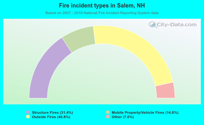 When looking into fire subcategories, the most reports belonged to: Outside Fires (46.8%), and Structure Fires (31.4%).
Fire-safe hotels and motels in Salem, New Hampshire:
- La Quinta Inn & Suites, 8 Keewaydin Dr, Salem, New Hampshire 03079 , Phone: (603) 893-4722, Fax: (603) 893-2898
- Red Roof Inns, 15 Red Roof Ln, Salem, New Hampshire 03079 , Phone: (603) 898-6422, Fax: (603) 898-6497
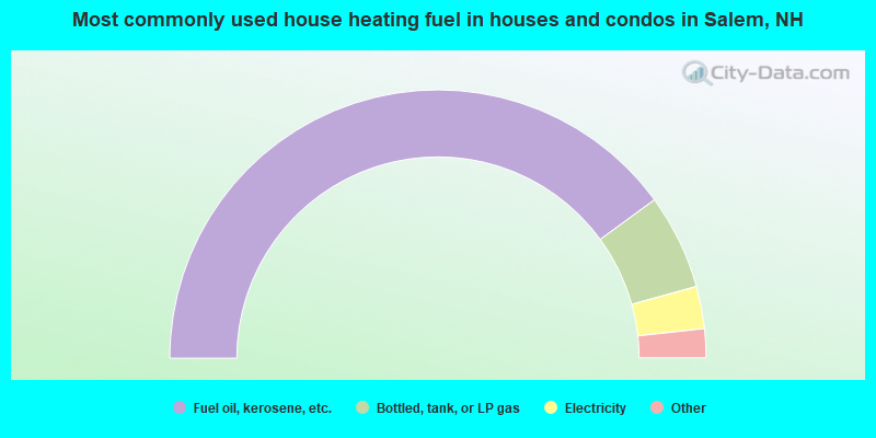
- 79.9%Fuel oil, kerosene, etc.
- 11.5%Bottled, tank, or LP gas
- 5.1%Electricity
- 2.0%Utility gas
- 1.0%Wood
- 0.5%Other fuel
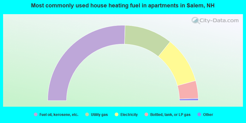
- 50.9%Fuel oil, kerosene, etc.
- 20.6%Utility gas
- 20.0%Electricity
- 7.6%Bottled, tank, or LP gas
- 0.5%No fuel used
- 0.4%Coal or coke
Salem compared to New Hampshire state average:
- Unemployed percentage significantly below state average.
- Black race population percentage below state average.
- Length of stay since moving in significantly above state average.
- Number of rooms per house significantly below state average.
- House age significantly below state average.
Salem on our top lists:
- #9 on the list of "Top 101 cities with largest percentage of females in industries: computer and electronic products (population 5,000+)"
- #17 on the list of "Top 101 cities with largest percentage of females in occupations: engineers (population 5,000+)"
- #27 on the list of "Top 101 cities with largest percentage of males in occupations: operations specialties managers except financial managers (population 5,000+)"
- #33 on the list of "Top 101 cities with largest percentage of males in industries: computer and electronic products (population 5,000+)"
- #54 on the list of "Top 101 cities with largest percentage of males in occupations: material recording, scheduling, dispatching, and distributing workers (population 5,000+)"
- #55 on the list of "Top 101 cities with largest percentage of males in industries: radio, tv, and computer stores (population 5,000+)"
- #67 on the list of "Top 101 cities with largest percentage of males in industries: farm product raw materials merchant wholesalers (population 5,000+)"
- #69 on the list of "Top 101 cities with largest percentage of females in industries: farm supplies merchant wholesalers (population 5,000+)"
- #77 on the list of "Top 101 cities with largest percentage of males in industries: leather and allied products (population 5,000+)"
- #88 on the list of "Top 101 cities with largest percentage of males in industries: sporting goods, camera, and hobby and toy stores (population 5,000+)"
- #97 on the list of "Top 101 cities with largest percentage of females in industries: pharmacies and drug stores (population 5,000+)"
- #9 on the list of "Top 101 counties with the largest decrease in the number of births per 1000 residents 2000-2006 to 2007-2013 (pop 50,000+)"
- #14 on the list of "Top 101 counties with the best general health status score of residents (1-5), 3 years of data"
- #16 on the list of "Top 101 counties with the lowest number of births per 1000 residents 2007-2013"
- #22 on the list of "Top 101 counties with the lowest Particulate Matter (PM10) Annual air pollution readings in 2012 (µg/m3)"
- #36 on the list of "Top 101 counties with the highest percentage of residents that visited a dentist within the past year"

|
|
Total of 453 patent applications in 2008-2024.