Saratt, South Carolina
Submit your own pictures of this place and show them to the world
- OSM Map
- General Map
- Google Map
- MSN Map

| Males: 1,687 | |
| Females: 1,671 |
| Median resident age: | 35.5 years |
| South Carolina median age: | 35.4 years |
Zip code: 29372
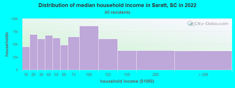
| Saratt: | $52,281 |
| SC: | $64,115 |
Estimated per capita income in 2022: $25,309 (it was $15,306 in 2000)
Saratt CCD income, earnings, and wages data
Estimated median house or condo value in 2022: $133,404 (it was $60,600 in 2000)
| Saratt: | $133,404 |
| SC: | $254,600 |
Detailed information about poverty and poor residents in Saratt, SC
Compare current foreclosures near Saratt, SC:
| Photo | Address | Area | Beds / Baths | Price | Details |
|---|---|---|---|---|---|

|
#1
Dogwood Ave
Spartanburg, SC 29302
|
2,069 sq. feet
|
2 baths 4 beds |
show details | |

|
#2
Gardner Rd
Gaffney, SC 29341
|
- sq. feet
|
2 baths 3 beds |
show details | |

|
#3
E Fremont Ave
Spartanburg, SC 29303
|
1,537 sq. feet
|
2 baths 3 beds |
show details | |

|
#4
Marconi Dr
Spartanburg, SC 29303
|
2,413 sq. feet
|
2 baths 5 beds |
show details | |

|
#5
Hillcrest Blvd
Spartanburg, SC 29307
|
1,156 sq. feet
|
1 baths 3 beds |
show details | |

|
#6
Mcarthur St
Gaffney, SC 29340
|
1,036 sq. feet
|
1 baths 3 beds |
show details | |

|
#7
Goucher School Rd
Gaffney, SC 29340
|
- sq. feet
|
- baths - beds |
$25,000
|
show details |

|
#8
Southview Ave
Spartanburg, SC 29302
|
1,600 sq. feet
|
2 baths 3 beds |
show details | |

|
#9
Longbow Dr
Spartanburg, SC 29302
|
1,627 sq. feet
|
1 baths 3 beds |
show details | |

|
#10
Bud Arthur Bridge Rd
Spartanburg, SC 29307
|
1,152 sq. feet
|
2 baths 3 beds |
show details |
| Photo | Address | Area | Beds / Baths | Price | Details |
|---|---|---|---|---|---|

|
#11
W Croft Cir
Spartanburg, SC 29302
|
1,832 sq. feet
|
1 baths 5 beds |
show details | |

|
#12
Stewart St
Spartanburg, SC 29306
|
1,040 sq. feet
|
1 baths 3 beds |
show details | |

|
#13
Double Branch Rd
Cowpens, SC 29330
|
1,800 sq. feet
|
2 baths 3 beds |
show details | |

|
#14
Southview Ave
Spartanburg, SC 29302
|
1,417 sq. feet
|
2 baths 3 beds |
show details | |

|
#15
Keltner Ave
Spartanburg, SC 29302
|
1,372 sq. feet
|
1 baths 3 beds |
show details | |

|
#16
Plainview Drive Ext
Spartanburg, SC 29307
|
2,000 sq. feet
|
1 baths 3 beds |
show details | |

|
#17
Lake Forest Dr
Spartanburg, SC 29307
|
3,476 sq. feet
|
3 baths 4 beds |
show details | |

|
#18
Calhoun Estates Dr
Spartanburg, SC 29307
|
1,152 sq. feet
|
2 baths 3 beds |
show details | |

|
#19
High St
Spartanburg, SC 29306
|
1,152 sq. feet
|
1 baths 3 beds |
show details | |

|
#20
Roswell Ter
Spartanburg, SC 29307
|
2,358 sq. feet
|
3 baths 4 beds |
show details |
| Photo | Address | Area | Beds / Baths | Price | Details |
|---|---|---|---|---|---|

|
#21
Mount Lebanon Rd
Pauline, SC 29374
|
720 sq. feet
|
1 baths 3 beds |
show details | |

|
#22
Hospital St
Spartanburg, SC 29302
|
1,372 sq. feet
|
2 baths 3 beds |
show details | |

|
#23
Sunset Dr
Cowpens, SC 29330
|
1,321 sq. feet
|
1 baths 3 beds |
show details | |

|
#24
Bud Arthur Bridge Rd
Cowpens, SC 29330
|
1,216 sq. feet
|
2 baths 3 beds |
show details | |

|
#25
Carver St
Gaffney, SC 29341
|
- sq. feet
|
1 baths 3 beds |
show details | |

|
#26
Woodhaven Dr
Spartanburg, SC 29307
|
1,324 sq. feet
|
1 baths 3 beds |
show details | |

|
#27
Maywood St
Spartanburg, SC 29303
|
650 sq. feet
|
1 baths 2 beds |
show details | |

|
#28
Limestone Dr
Spartanburg, SC 29306
|
1,511 sq. feet
|
1 baths 3 beds |
show details | |

|
#29
Spruce St
Gaffney, SC 29340
|
- sq. feet
|
- baths - beds |
$25,000
|
show details |

|
#30
Kelly Rd
Spartanburg, SC 29307
|
1,188 sq. feet
|
1 baths 2 beds |
show details |
| Photo | Address | Area | Beds / Baths | Price | Details |
|---|---|---|---|---|---|

|
#31
Park Dr
Union, SC 29379
|
1,506 sq. feet
|
3 baths 5 beds |
show details | |

|
#32
Blackstock Rd
Pauline, SC 29374
|
898 sq. feet
|
1 baths 2 beds |
show details | |

|
#33
Washington Rd
Spartanburg, SC 29302
|
1,632 sq. feet
|
1 baths 3 beds |
show details | |

|
#34
Elmwood Dr
Spartanburg, SC 29303
|
1,862 sq. feet
|
2 baths 3 beds |
show details | |

|
#35
Bearden Heights Rd
Spartanburg, SC 29306
|
1,904 sq. feet
|
2 baths 3 beds |
show details | |

|
#36
Joe Arthur Dr
Roebuck, SC 29376
|
1,403 sq. feet
|
2 baths 3 beds |
show details | |

|
#37
Marconi Dr
Spartanburg, SC 29303
|
1,624 sq. feet
|
1 baths 4 beds |
show details | |

|
#38
Dogwood Dr
Pacolet, SC 29372
|
1,160 sq. feet
|
1 baths 3 beds |
show details | |

|
#39
Bethesda Dr
Spartanburg, SC 29302
|
1,866 sq. feet
|
2 baths 3 beds |
show details | |

|
#40
New Faith Ct
Spartanburg, SC 29301
|
1,066 sq. feet
|
1 baths 3 beds |
show details |
| Photo | Address | Area | Beds / Baths | Price | Details |
|---|---|---|---|---|---|

|
#41
Deer Springs Rd
Spartanburg, SC 29302
|
2,016 sq. feet
|
2 baths 3 beds |
show details | |

|
#42
Kinsland Dr
Chesnee, SC 29323
|
1,456 sq. feet
|
2 baths 3 beds |
show details | |

|
#43
Collins Ave
Spartanburg, SC 29306
|
1,324 sq. feet
|
2 baths 3 beds |
show details | |

|
#44
Tumble Rock Dr
Cowpens, SC 29330
|
1,792 sq. feet
|
2 baths 3 beds |
show details | |

|
#45
Sunridge Ct
Spartanburg, SC 29302
|
1,340 sq. feet
|
2 baths 3 beds |
show details | |

|
#46
Clifdale Rd
Spartanburg, SC 29307
|
780 sq. feet
|
1 baths 2 beds |
show details | |

|
#47
Emory Oak Way
Cowpens, SC 29330
|
1,792 sq. feet
|
2 baths 3 beds |
show details | |

|
#48
Sunnyview Cir
Spartanburg, SC 29307
|
1,187 sq. feet
|
1 baths 2 beds |
show details | |

|
#49
S Pine St
Spartanburg, SC 29302
|
708 sq. feet
|
1 baths - beds |
show details | |

|
Check over 1 million property listings on Foreclosure.com!
|
browse all offers | |||

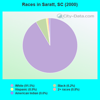
- 2,98991.5%White alone
- 2016.2%Black alone
- 280.9%Hispanic
- 250.8%Two or more races
- 180.6%American Indian alone
- 30.09%Other race alone
- 20.06%Asian alone
Races in Saratt detailed stats: ancestries, foreign born residents, place of birth
 Recent articles from our blog. Our writers, many of them Ph.D. graduates or candidates, create easy-to-read articles on a wide variety of topics.
Current Local Time: EST time zone
Elevation: 627 feet
Land area: 75.8 square miles.
Population density: 44 people per square mile (very low).

| Saratt CCD: | 0.6% ($387) |
| South Carolina: | 0.6% ($510) |
Nearest city with pop. 50,000+: Gastonia, NC  (34.8 miles , pop. 66,277).
Nearest city with pop. 200,000+: Charlotte, NC (50.7 miles , pop. 540,828).
Nearest city with pop. 1,000,000+: Philadelphia, PA (500.0 miles , pop. 1,517,550).
Nearest cities:
), ), ), ), ), )Latitude: 34.94 N, Longitude: 81.66 W
Area code commonly used in this area: 864

| Here: | 4.0% |
| South Carolina: | 3.1% |
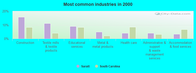
- Construction (15.7%)
- Textile mills & textile products (11.1%)
- Educational services (9.1%)
- Metal & metal products (5.0%)
- Health care (4.1%)
- Administrative & support & waste management services (4.0%)
- Accommodation & food services (3.4%)
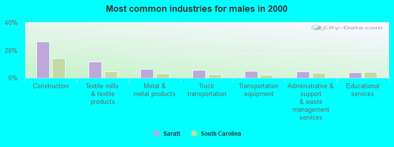
- Construction (26.0%)
- Textile mills & textile products (11.6%)
- Metal & metal products (6.4%)
- Truck transportation (5.8%)
- Transportation equipment (5.0%)
- Administrative & support & waste management services (4.6%)
- Educational services (4.1%)
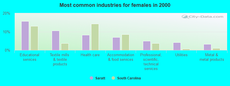
- Educational services (15.7%)
- Textile mills & textile products (10.5%)
- Health care (8.2%)
- Accommodation & food services (7.0%)
- Professional, scientific, technical services (5.0%)
- Utilities (4.3%)
- Metal & metal products (3.2%)
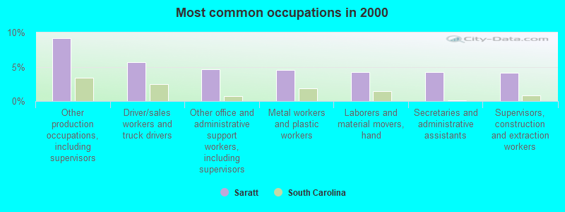
- Other production occupations, including supervisors (9.2%)
- Driver/sales workers and truck drivers (5.7%)
- Other office and administrative support workers, including supervisors (4.6%)
- Metal workers and plastic workers (4.5%)
- Laborers and material movers, hand (4.2%)
- Secretaries and administrative assistants (4.2%)
- Supervisors, construction and extraction workers (4.1%)
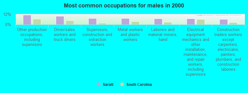
- Other production occupations, including supervisors (11.2%)
- Driver/sales workers and truck drivers (10.0%)
- Supervisors, construction and extraction workers (7.2%)
- Metal workers and plastic workers (7.2%)
- Laborers and material movers, hand (6.9%)
- Electrical equipment mechanics and other installation, maintenance, and repair workers, including supervisors (6.9%)
- Construction traders workers except carpenters, electricians, painters, plumbers, and construction laborers (6.0%)
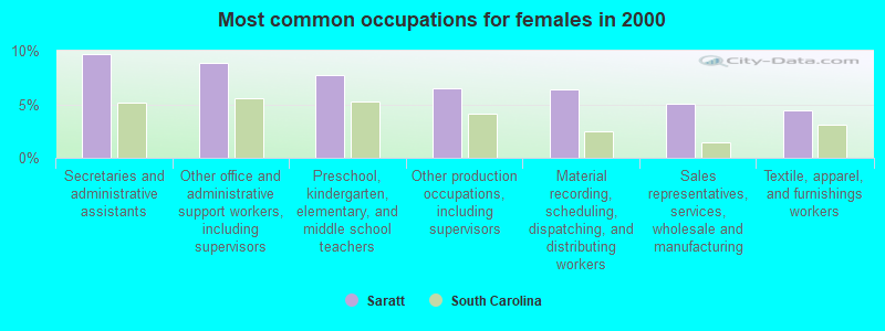
- Secretaries and administrative assistants (9.7%)
- Other office and administrative support workers, including supervisors (8.8%)
- Preschool, kindergarten, elementary, and middle school teachers (7.8%)
- Other production occupations, including supervisors (6.5%)
- Material recording, scheduling, dispatching, and distributing workers (6.4%)
- Sales representatives, services, wholesale and manufacturing (5.0%)
- Textile, apparel, and furnishings workers (4.4%)
Average climate in Saratt, South Carolina
Based on data reported by over 4,000 weather stations


(lower is better)
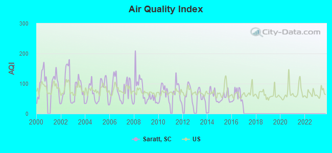
Air Quality Index (AQI) level in 2016 was 59.1. This is better than average.
| City: | 59.1 |
| U.S.: | 72.6 |
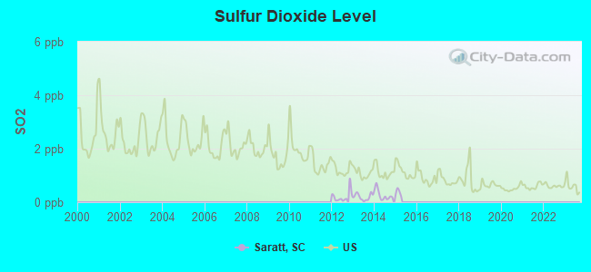
Sulfur Dioxide (SO2) [ppb] level in 2014 was 0.267. This is significantly better than average. Closest monitor was 15.2 miles away from the city center.
| City: | 0.267 |
| U.S.: | 1.515 |
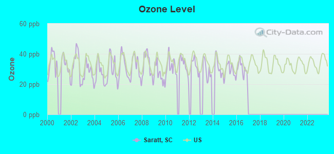
Ozone [ppb] level in 2016 was 29.5. This is about average. Closest monitor was 15.5 miles away from the city center.
| City: | 29.5 |
| U.S.: | 33.3 |
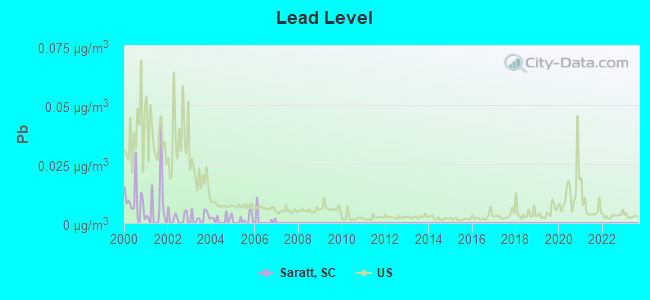
Lead (Pb) [µg/m3] level in 2007 was 0.00000. This is significantly better than average. Closest monitor was 15.2 miles away from the city center.
| City: | 0.00000 |
| U.S.: | 0.00931 |
Tornado activity:
Saratt-area historical tornado activity is near South Carolina state average. It is 13% greater than the overall U.S. average.
On 5/5/1989, a category F4 (max. wind speeds 207-260 mph) tornado 17.7 miles away from the Saratt place center killed 2 people and injured 35 people and caused between $500,000 and $5,000,000 in damages.
On 8/16/1994, a category F3 (max. wind speeds 158-206 mph) tornado 9.1 miles away from the place center caused between $50,000 and $500,000 in damages.
Earthquake activity:
Saratt-area historical earthquake activity is significantly above South Carolina state average. It is 4% smaller than the overall U.S. average.On 8/9/2020 at 12:07:37, a magnitude 5.1 (5.1 MW, Depth: 4.7 mi, Class: Moderate, Intensity: VI - VII) earthquake occurred 110.6 miles away from the city center
On 8/2/1974 at 08:52:09, a magnitude 4.9 (4.3 MB, 4.9 LG, Class: Light, Intensity: IV - V) earthquake occurred 87.8 miles away from the city center
On 8/23/2011 at 17:51:04, a magnitude 5.8 (5.8 MW, Depth: 3.7 mi) earthquake occurred 291.7 miles away from the city center
On 11/30/1973 at 07:48:41, a magnitude 4.7 (4.7 MB, 4.6 ML) earthquake occurred 142.4 miles away from Saratt center
On 7/27/1980 at 18:52:21, a magnitude 5.2 (5.1 MB, 4.7 MS, 5.0 UK, 5.2 UK) earthquake occurred 258.6 miles away from the city center
On 11/22/1974 at 05:25:55, a magnitude 4.7 (4.7 MB) earthquake occurred 166.1 miles away from the city center
Magnitude types: regional Lg-wave magnitude (LG), body-wave magnitude (MB), local magnitude (ML), surface-wave magnitude (MS), moment magnitude (MW)
Natural disasters:
The number of natural disasters in Cherokee County (13) is near the US average (15).Major Disasters (Presidential) Declared: 6
Emergencies Declared: 5
Causes of natural disasters: Hurricanes: 3, Ice Storms: 3, Floods: 2, Storms: 2, Winter Storms: 2, Drought: 1, Tropical Storm: 1, Other: 1 (Note: some incidents may be assigned to more than one category).
Hospitals and medical centers near Saratt:
- BROOKVIEW HEALTHCARE CENTER (Nursing Home, about 8 miles away; GAFFNEY, SC)
- DCI GAFFNEY (Dialysis Facility, about 9 miles away; GAFFNEY, SC)
- J.CLAUDE FORT II (Hospital, about 10 miles away; GAFFNEY, SC)
- CHEROKEE COUNTY LTC FACILITY (Nursing Home, about 11 miles away; GAFFNEY, SC)
- NOVANT HEALTH GAFFNEY MEDICAL CENTER Acute Care Hospitals (about 11 miles away; GAFFNEY, SC)
- WHITE OAK ESTATES (Nursing Home, about 12 miles away; SPARTANBURG, SC)
- ELLEN SAGAR NURSING HOME (Nursing Home, about 13 miles away; UNION, SC)
Colleges/universities with over 2000 students nearest to Saratt:
- Limestone College (about 8 miles; Gaffney, SC; Full-time enrollment: 2,758)
- University of South Carolina-Upstate (about 18 miles; Spartanburg, SC; FT enrollment: 4,994)
- Spartanburg Community College (about 19 miles; Spartanburg, SC; FT enrollment: 4,309)
- Gardner-Webb University (about 21 miles; Boiling Springs, NC; FT enrollment: 4,241)
- Cleveland Community College (about 26 miles; Shelby, NC; FT enrollment: 2,541)
- Isothermal Community College (about 31 miles; Spindale, NC; FT enrollment: 2,165)
- Winthrop University (about 37 miles; Rock Hill, SC; FT enrollment: 5,575)
Points of interest:
Notable locations in Saratt: Asbury Rehobeth Volunteer Fire Department (A), Goucher - White Plains Fire Department (B), Twin River Fire Department (C). Display/hide their locations on the map
Churches in Saratt include: Rehobeth Church (A), Oakdale Church (B), Green Bethel Church (C), Love Springs Church (D), White Plains Baptist Church (E), White Plains Baptist Church of Christ (F), Mesopotamia Church (G), Knuckles Chapel (H), Gowdeysville Baptist Church (I). Display/hide their locations on the map
Cemeteries: Pleasant Grove Cemetery (1), Asbury Cemetery (2), Green Bethel Cemetery (3), Willis Cemetery (4). Display/hide their locations on the map
Reservoirs: Thicketty Creek Watershed 25 Reservoir (A), Hammett Lake (B). Display/hide their locations on the map
Streams, rivers, and creeks: Pacolet River (A), Plum Branch (B), Mill Creek (C), Mill Branch (D), Little Thicketty Creek (E), Limestone Creek (F), Kendrick Branch (G), Gum Root Creek (H), Crocker Branch (I). Display/hide their locations on the map
| This place: | 2.6 people |
| South Carolina: | 2.5 people |
| This place: | 71.5% |
| Whole state: | 67.5% |
| This place: | 7.2% |
| Whole state: | 6.0% |
Likely homosexual households (counted as self-reported same-sex unmarried-partner households)
- Lesbian couples: 0.4% of all households
- Gay men: 0.3% of all households
| This place: | 12.4% |
| Whole state: | 14.1% |
| This place: | 4.7% |
| Whole state: | 6.5% |
For population 15 years and over in Saratt:
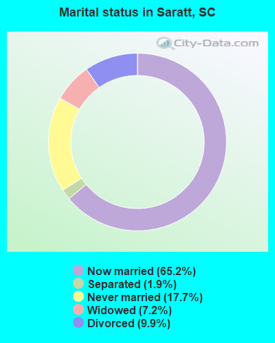
- Never married: 17.7%
- Now married: 65.2%
- Separated: 1.9%
- Widowed: 7.2%
- Divorced: 9.9%
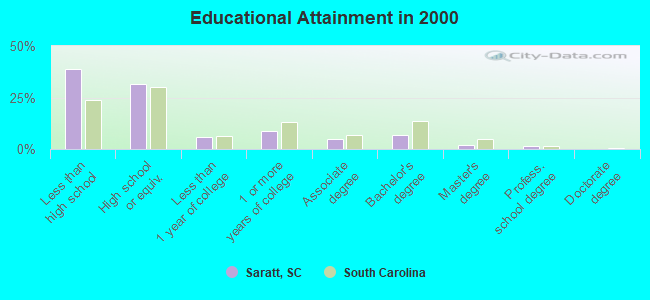
For population 25 years and over in Saratt:
- High school or higher: 61.2%
- Bachelor's degree or higher: 10.2%
- Graduate or professional degree: 3.2%
- Unemployed: 4.9%
- Mean travel time to work (commute): 33.8 minutes
| Here: | 14.9 |
| South Carolina average: | 13.2 |
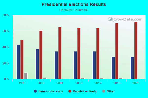
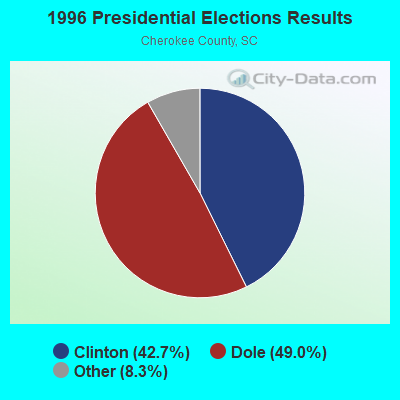
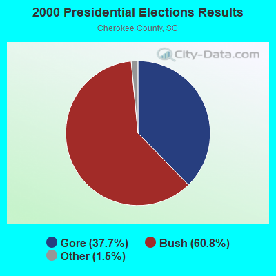
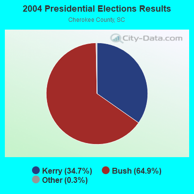
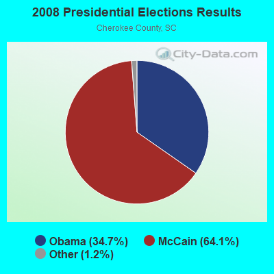


Graphs represent county-level data. Detailed 2008 Election Results
Religion statistics for Saratt, SC (based on Cherokee County data)
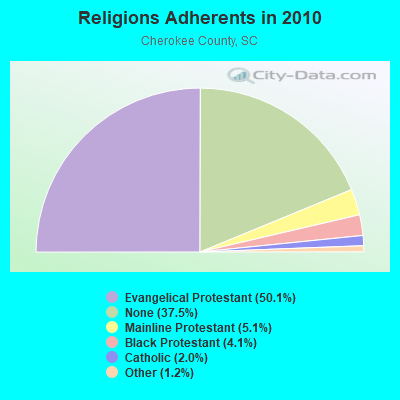
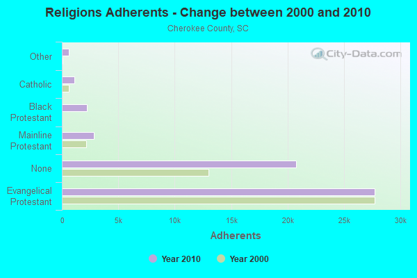
| Religion | Adherents | Congregations |
|---|---|---|
| Evangelical Protestant | 27,748 | 84 |
| Mainline Protestant | 2,830 | 15 |
| Black Protestant | 2,243 | 10 |
| Catholic | 1,100 | 1 |
| Other | 644 | 2 |
| None | 20,777 | - |
Food Environment Statistics:
| Cherokee County: | 1.48 / 10,000 pop. |
| State: | 1.99 / 10,000 pop. |
| Cherokee County: | 0.19 / 10,000 pop. |
| South Carolina: | 0.15 / 10,000 pop. |
| Here: | 1.67 / 10,000 pop. |
| State: | 0.85 / 10,000 pop. |
| Cherokee County: | 7.42 / 10,000 pop. |
| State: | 5.38 / 10,000 pop. |
| Here: | 7.60 / 10,000 pop. |
| South Carolina: | 7.75 / 10,000 pop. |
| Cherokee County: | 11.6% |
| South Carolina: | 10.6% |
| Here: | 29.6% |
| State: | 29.4% |
| Cherokee County: | 13.5% |
| State: | 13.4% |
Strongest AM radio stations in Saratt:
- WBCU (1460 AM; 50 kW; UNION, SC)
- WFGN (1180 AM; daytime; 2 kW; GAFFNEY, SC; Owner: HOPE BROADCASTING, INC.)
- WLFJ (660 AM; daytime; 50 kW; GREENVILLE, SC; Owner: CLEAR CHANNEL BROADCASTING LICENSES, INC.)
- WCSZ (1070 AM; 50 kW; SANS SOUCI, SC; Owner: WHYZ RADIO, L.P.)
- WBT (1110 AM; 50 kW; CHARLOTTE, NC; Owner: JEFFERSON-PILOT COMMUNICATNS CO. OF NORTH CAROLINA)
- WAGL (1560 AM; daytime; 50 kW; LANCASTER, SC; Owner: PALMETTO BROADCASTING SYSTEM, INC.)
- WORD (950 AM; 5 kW; SPARTANBURG, SC; Owner: ENTERCOM GREENVILLE LICENSE, LLC)
- WFGW (1010 AM; 50 kW; BLACK MOUNTAIN, NC; Owner: BLUE RIDGE BROADCASTING CORP.)
- WWOL (780 AM; daytime; 10 kW; FOREST CITY, NC; Owner: HOLLY SPRINGS BAPTIST BROADCASTING CO., INC.)
- WBAJ (890 AM; daytime; 50 kW; BLYTHEWOOD, SC; Owner: FAMILY FIRST)
- WCEO (840 AM; daytime; 50 kW; COLUMBIA, SC; Owner: EASTERN BROADCASTING GROUP, INC.)
- WHKY (1290 AM; 50 kW; HICKORY, NC; Owner: LONG COMMUNICATIONS, LLC.)
- WLTC (1370 AM; 20 kW; GASTONIA, NC)
Strongest FM radio stations in Saratt:
- WSSL-FM (100.5 FM; GRAY COURT, SC; Owner: CAPSTAR TX LIMITED PARTNERSHIP)
- WYFG (91.1 FM; GAFFNEY, SC; Owner: BIBLE BROADCASTING NETWORK, INC.)
- WBAV-FM (101.9 FM; GASTONIA, NC; Owner: INFINITY RADIO SUBSIDIARY OPERATIONS INC.)
- WTPT (93.3 FM; FOREST CITY, NC; Owner: UPSTATE BROADCASTING, LLC)
- WSPA-FM (98.9 FM; SPARTANBURG, SC; Owner: ENTERCOM GREENVILLE LICENSE, LLC)
- WFBC-FM (93.7 FM; GREENVILLE, SC; Owner: ENTERCOM GREENVILLE LICENSE, LLC)
- WAGI-FM (105.3 FM; GAFFNEY, SC; Owner: GAFFNEY BROADCASTING, INC.)
- WLNK (107.9 FM; CHARLOTTE, NC; Owner: JEFFERSON-PILOT COMMUNICATIONS COMPANY OF NORTH CAROLINA)
- WMIT (106.9 FM; BLACK MOUNTAIN, NC; Owner: BLUE RIDGE BROADCASTING CORPORATION)
- WNCW (88.7 FM; SPINDALE, NC; Owner: ISOTHERMAL COMMUNITY COLLEGE)
- WPEG (97.9 FM; CONCORD, NC; Owner: INFINITY RADIO SUBSIDIARY OPERATIONS INC.)
- WNKS (95.1 FM; CHARLOTTE, NC; Owner: INFINITY RADIO SUBSIDIARY OPERATIONS INC.)
- WROQ (101.1 FM; ANDERSON, SC; Owner: OBC BROADCASTING, INC.)
- WWMG (96.1 FM; SHELBY, NC; Owner: CLEAR CHANNEL BROADCASTING LICENSES, INC.)
- WLYT (102.9 FM; HICKORY, NC; Owner: CAPSTAR TX LIMITED PARTNERSHIP)
- WESC-FM (92.5 FM; GREENVILLE, SC; Owner: CLEAR CHANNEL BROADCASTING LICENSES, INC.)
- WKKT (96.9 FM; STATESVILLE, NC; Owner: CAPSTAR TX LIMITED PARTNERSHIP)
- WKSF (99.9 FM; ASHEVILLE, NC; Owner: CAPSTAR TX LIMITED PARTNERSHIP)
- WMYI (102.5 FM; HENDERSONVILLE, NC; Owner: CAPSTAR TX LIMITED PARTNERSHIP)
- W219CH (91.7 FM; LOWRYS, SC; Owner: RICHBURG EDUCATIONAL BROADCASTERS, INC.)
TV broadcast stations around Saratt:
- WRET-TV (Channel 49; SPARTANBURG, SC; Owner: SOUTH CAROLINA EDUCATIONAL TV COMMISSION)
- WSQY-LP (Channel 66; SPARTANBURG, SC; Owner: ASHEVILLE MEDIA GROUP, LLC)
- WBTV (Channel 3; CHARLOTTE, NC; Owner: JEFFERSON-PILOT COMMUNICATIONS/WBTV, INC.)
- WCNC-TV (Channel 36; CHARLOTTE, NC; Owner: WCNC-TV, INC.)
- WJZY (Channel 46; BELMONT, NC; Owner: WJZY-TV, INC.)
- WWWB (Channel 55; ROCK HILL, SC; Owner: WWWB-TV, INC.)
- WASV-TV (Channel 62; ASHEVILLE, NC; Owner: MEDIA GENERAL BROADCASTING OF SOUTH CAROLINA HOLDINGS, INC.)
- WBSC-TV (Channel 40; ANDERSON, SC; Owner: ANDERSON (WFBC-TV) LICENSEE, INC.)
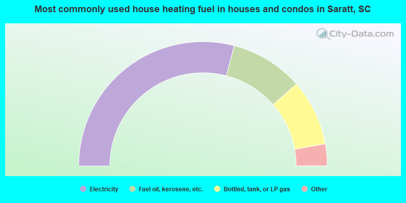
- 58.1%Electricity
- 19.0%Fuel oil, kerosene, etc.
- 17.2%Bottled, tank, or LP gas
- 3.9%Wood
- 1.3%Utility gas
- 0.6%Other fuel
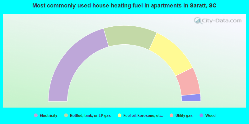
- 41.1%Electricity
- 22.9%Bottled, tank, or LP gas
- 21.3%Fuel oil, kerosene, etc.
- 11.5%Utility gas
- 3.2%Wood
Saratt compared to South Carolina state average:
- Median house value below state average.
- Unemployed percentage significantly below state average.
- Black race population percentage significantly below state average.
- Hispanic race population percentage significantly below state average.
- Foreign-born population percentage significantly below state average.
- Length of stay since moving in significantly above state average.
- Number of rooms per house significantly below state average.
- House age significantly below state average.
- Number of college students significantly below state average.
- Percentage of population with a bachelor's degree or higher below state average.