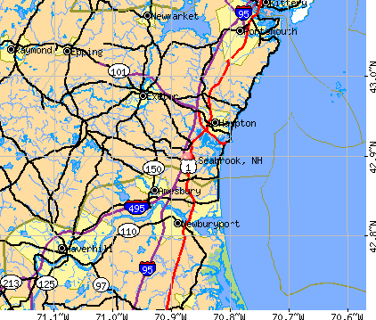
Seabrook, New Hampshire

Seabrook: A secluded and lonely swing in Seabrook

Seabrook: A beautiful days ends with an equally beautiful sunset over Seabrook Beach
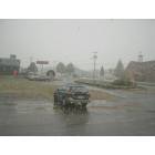
Seabrook: 1st Snow October 2005 Town Offices to right

Seabrook: Railroad Ave Tree Fall 2008
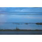
Seabrook: Cross Beach High Run Tide
- add
your
Submit your own pictures of this town and show them to the world
- OSM Map
- General Map
- Google Map
- MSN Map
Population change since 2000: +9.6%
 |
| Males: 4,325 | |
| Females: 4,368 |
| Median resident age: | 44.6 years |
| New Hampshire median age: | 43.9 years |
Zip codes: 03874.
| Seabrook: | $79,217 |
| NH: | $89,992 |
Estimated per capita income in 2022: $46,080 (it was $20,992 in 2000)
Seabrook town income, earnings, and wages data
Estimated median house or condo value in 2022: $429,310 (it was $140,500 in 2000)
| Seabrook: | $429,310 |
| NH: | $384,700 |
Mean prices in 2022: all housing units: $614,227; detached houses: $665,470; townhouses or other attached units: $408,866; in 2-unit structures: $730,084; in 3-to-4-unit structures: over $1,000,000; in 5-or-more-unit structures: $329,099; mobile homes: $126,160
Detailed information about poverty and poor residents in Seabrook, NH


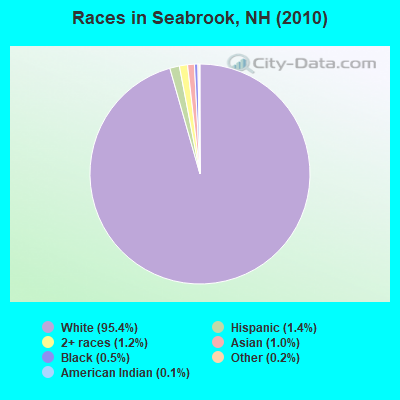
- 8,29695.4%White alone
- 1261.4%Hispanic
- 1081.2%Two or more races
- 911.0%Asian alone
- 450.5%Black alone
- 180.2%Other race alone
- 90.1%American Indian alone
Races in Seabrook detailed stats: ancestries, foreign born residents, place of birth
According to our research of New Hampshire and other state lists, there were 19 registered sex offenders living in Seabrook, New Hampshire as of May 02, 2024.
The ratio of all residents to sex offenders in Seabrook is 458 to 1.
The ratio of registered sex offenders to all residents in this city is near the state average.
Type |
2009 |
2010 |
2011 |
2012 |
2013 |
2014 |
2015 |
2016 |
2017 |
2018 |
2019 |
2020 |
2021 |
|---|---|---|---|---|---|---|---|---|---|---|---|---|---|
| Murders (per 100,000) | 0 (0.0) | 0 (0.0) | 0 (0.0) | 0 (0.0) | 0 (0.0) | 0 (0.0) | 0 (0.0) | 0 (0.0) | 0 (0.0) | 1 (11.2) | 0 (0.0) | 0 (0.0) | 0 (0.0) |
| Rapes (per 100,000) | 0 (0.0) | 2 (23.0) | 1 (11.5) | 3 (34.3) | 3 (34.1) | 2 (22.8) | 4 (45.3) | 3 (34.1) | 2 (22.7) | 0 (0.0) | 1 (11.3) | 3 (33.8) | 2 (22.3) |
| Robberies (per 100,000) | 1 (11.7) | 1 (11.5) | 2 (23.0) | 4 (45.8) | 7 (79.5) | 2 (22.8) | 1 (11.3) | 3 (34.1) | 2 (22.7) | 4 (44.7) | 1 (11.3) | 0 (0.0) | 2 (22.3) |
| Assaults (per 100,000) | 10 (116.9) | 12 (138.0) | 10 (114.9) | 16 (183.1) | 21 (238.5) | 11 (125.4) | 9 (101.9) | 16 (181.7) | 17 (192.8) | 11 (123.0) | 2 (22.5) | 4 (45.1) | 7 (78.0) |
| Burglaries (per 100,000) | 55 (643.2) | 21 (241.6) | 23 (264.2) | 36 (412.0) | 25 (283.9) | 20 (227.9) | 16 (181.2) | 17 (193.1) | 25 (283.6) | 11 (123.0) | 16 (180.2) | 5 (56.4) | 4 (44.6) |
| Thefts (per 100,000) | 327 (3,824) | 274 (3,152) | 234 (2,688) | 180 (2,060) | 233 (2,646) | 284 (3,237) | 199 (2,254) | 218 (2,476) | 182 (2,064) | 138 (1,543) | 122 (1,374) | 146 (1,646) | 179 (1,995) |
| Auto thefts (per 100,000) | 17 (198.8) | 9 (103.5) | 9 (103.4) | 6 (68.7) | 11 (124.9) | 9 (102.6) | 6 (68.0) | 11 (124.9) | 11 (124.8) | 8 (89.5) | 5 (56.3) | 8 (90.2) | 15 (167.1) |
| Arson (per 100,000) | 0 (0.0) | 3 (34.5) | 0 (0.0) | 0 (0.0) | 0 (0.0) | 0 (0.0) | 3 (34.0) | 2 (22.7) | 1 (11.3) | 0 (0.0) | 0 (0.0) | 0 (0.0) | 0 (0.0) |
| City-Data.com crime index | 240.8 | 200.7 | 173.4 | 194.6 | 234.5 | 203.8 | 168.3 | 196.4 | 175.9 | 137.9 | 89.0 | 113.1 | 136.4 |
The City-Data.com crime index weighs serious crimes and violent crimes more heavily. Higher means more crime, U.S. average is 246.1. It adjusts for the number of visitors and daily workers commuting into cities.
Crime rate in Seabrook detailed stats: murders, rapes, robberies, assaults, burglaries, thefts, arson
Full-time law enforcement employees in 2021, including police officers: 34 (28 officers - 26 male; 2 female).
| Officers per 1,000 residents here: | 3.12 |
| New Hampshire average: | 2.14 |
 Recent articles from our blog. Our writers, many of them Ph.D. graduates or candidates, create easy-to-read articles on a wide variety of topics.

 | Nuclear Risk from Seabrook and EMP (7 replies) |
| Moving to Seabrook. Cable and Internet providers? (5 replies) |
| Bow (a/k/a) Merrimack Power Station (12 replies) |
| Moving to southeast NH, looking for suggestions (22 replies) |
| They are not protesters (66 replies) |
| Yet Another Guy Looking to Relocate to Southern NH (27 replies) |
Latest news from Seabrook, NH collected exclusively by city-data.com from local newspapers, TV, and radio stations
Ancestries: English (26.1%), Irish (19.3%), French (17.6%), Italian (9.7%), French Canadian (8.7%), Scottish (5.4%).
Current Local Time: EST time zone
Incorporated in 1768
Elevation: 56 feet
Land area: 8.86 square miles.
Population density: 981 people per square mile (low).
184 residents are foreign born (0.9% Europe, 0.9% North America, 0.3% Latin America, 0.2% Asia).
| This town: | 2.3% |
| New Hampshire: | 4.4% |
| Seabrook town: | 1.6% ($2,285) |
| New Hampshire: | 2.3% ($2,946) |
Nearest city with pop. 50,000+: Haverhill, MA  (13.8 miles , pop. 58,969).
Nearest city with pop. 200,000+: Boston, MA (40.7 miles , pop. 589,141).
Nearest city with pop. 1,000,000+: Bronx, NY (209.8 miles , pop. 1,332,650).
Nearest cities:
), ), ), )Latitude: 42.88 N, Longitude: 70.85 W
Area code: 603

Single-family new house construction building permits:
- 2022: 9 buildings, average cost: $232,800
- 2021: 5 buildings, average cost: $179,000
- 2020: 9 buildings, average cost: $131,300
- 2019: 6 buildings, average cost: $198,600
- 2018: 12 buildings, average cost: $108,900
- 2017: 5 buildings, average cost: $156,000
- 2016: 12 buildings, average cost: $150,300
- 2015: 12 buildings, average cost: $145,700
- 2014: 17 buildings, average cost: $154,800
- 2013: 15 buildings, average cost: $155,900
- 2012: 20 buildings, average cost: $166,400
- 2011: 18 buildings, average cost: $141,100
- 2010: 32 buildings, average cost: $132,600
- 2009: 17 buildings, average cost: $136,500
- 2008: 8 buildings, average cost: $114,500
- 2007: 17 buildings, average cost: $158,600
- 2006: 14 buildings, average cost: $146,800
- 2005: 45 buildings, average cost: $134,400
- 2004: 35 buildings, average cost: $113,400
- 2003: 29 buildings, average cost: $128,500
- 2002: 47 buildings, average cost: $89,500
- 2001: 53 buildings, average cost: $92,600
- 2000: 48 buildings, average cost: $96,400
- 1999: 81 buildings, average cost: $84,300
- 1998: 59 buildings, average cost: $76,900
- 1997: 88 buildings, average cost: $80,400

| Here: | 3.8% |
| New Hampshire: | 2.5% |
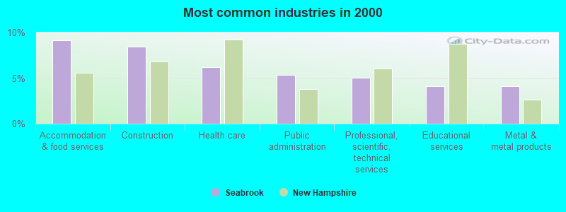
- Accommodation & food services (9.2%)
- Construction (8.4%)
- Health care (6.2%)
- Public administration (5.3%)
- Professional, scientific, technical services (5.1%)
- Educational services (4.1%)
- Metal & metal products (4.1%)
- Construction (15.0%)
- Accommodation & food services (7.3%)
- Public administration (7.1%)
- Metal & metal products (6.2%)
- Administrative & support & waste management services (4.9%)
- Computer & electronic products (4.2%)
- Professional, scientific, technical services (3.5%)
- Health care (12.0%)
- Accommodation & food services (11.3%)
- Professional, scientific, technical services (6.9%)
- Department & other general merchandise stores (6.7%)
- Educational services (5.7%)
- Food & beverage stores (4.2%)
- Social assistance (3.7%)
- Other production occupations, including supervisors (6.3%)
- Other management occupations, except farmers and farm managers (4.3%)
- Metal workers and plastic workers (4.2%)
- Building and grounds cleaning and maintenance occupations (4.0%)
- Other sales and related occupations, including supervisors (3.8%)
- Cooks and food preparation workers (3.0%)
- Supervisors and other personal care and service workers, except child care workers (2.9%)
- Other production occupations, including supervisors (8.4%)
- Metal workers and plastic workers (7.1%)
- Building and grounds cleaning and maintenance occupations (4.7%)
- Cooks and food preparation workers (4.7%)
- Vehicle and mobile equipment mechanics, installers, and repairers (4.3%)
- Electrical equipment mechanics and other installation, maintenance, and repair workers, including supervisors (4.2%)
- Other management occupations, except farmers and farm managers (4.2%)
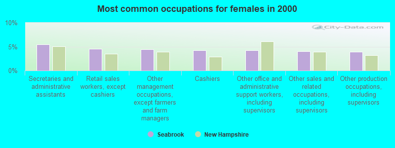
- Secretaries and administrative assistants (5.4%)
- Retail sales workers, except cashiers (4.5%)
- Other management occupations, except farmers and farm managers (4.4%)
- Cashiers (4.3%)
- Other office and administrative support workers, including supervisors (4.2%)
- Other sales and related occupations, including supervisors (4.1%)
- Other production occupations, including supervisors (3.9%)
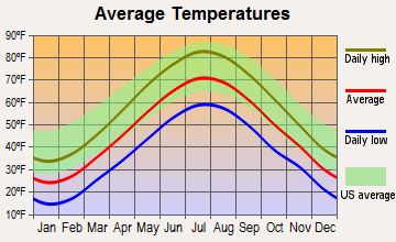
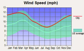
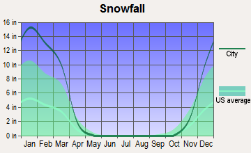
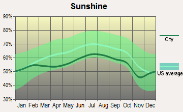
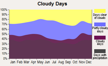
Average climate in Seabrook, New Hampshire
Based on data reported by over 4,000 weather stations
(lower is better)
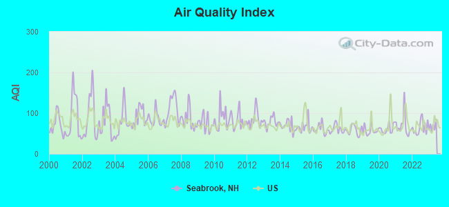
Air Quality Index (AQI) level in 2022 was 64.4. This is about average.
| City: | 64.4 |
| U.S.: | 72.6 |
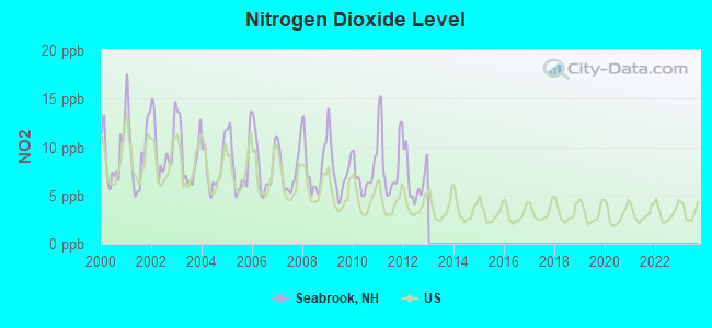
Nitrogen Dioxide (NO2) [ppb] level in 2012 was 6.65. This is worse than average. Closest monitor was 5.1 miles away from the city center.
| City: | 6.65 |
| U.S.: | 5.11 |
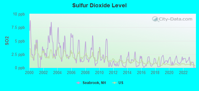
Sulfur Dioxide (SO2) [ppb] level in 2022 was 1.48. This is about average. Closest monitor was 5.1 miles away from the city center.
| City: | 1.48 |
| U.S.: | 1.51 |

Ozone [ppb] level in 2022 was 29.5. This is about average. Closest monitor was 6.9 miles away from the city center.
| City: | 29.5 |
| U.S.: | 33.3 |
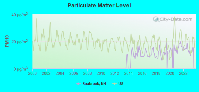
Particulate Matter (PM10) [µg/m3] level in 2022 was 14.4. This is better than average. Closest monitor was 14.2 miles away from the city center.
| City: | 14.4 |
| U.S.: | 19.2 |
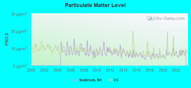
Particulate Matter (PM2.5) [µg/m3] level in 2022 was 6.66. This is better than average. Closest monitor was 14.2 miles away from the city center.
| City: | 6.66 |
| U.S.: | 8.11 |
Tornado activity:
Seabrook-area historical tornado activity is near New Hampshire state average. It is 53% smaller than the overall U.S. average.
On 6/9/1953, a category F3 (max. wind speeds 158-206 mph) tornado 8.3 miles away from the Seabrook town center injured 5 people and caused between $5000 and $50,000 in damages.
On 9/29/1974, a category F3 tornado 25.3 miles away from the town center injured one person and caused between $50,000 and $500,000 in damages.
Earthquake activity:
Seabrook-area historical earthquake activity is significantly above New Hampshire state average. It is 73% smaller than the overall U.S. average.On 10/16/2012 at 23:12:25, a magnitude 4.7 (4.7 ML, Depth: 10.0 mi, Class: Light, Intensity: IV - V) earthquake occurred 50.3 miles away from Seabrook center
On 4/20/2002 at 10:50:47, a magnitude 5.3 (5.3 ML, Depth: 3.0 mi, Class: Moderate, Intensity: VI - VII) earthquake occurred 181.3 miles away from Seabrook center
On 1/19/1982 at 00:14:42, a magnitude 4.7 (4.5 MB, 4.7 MD, 4.5 LG) earthquake occurred 56.8 miles away from Seabrook center
On 10/7/1983 at 10:18:46, a magnitude 5.3 (5.1 MB, 5.3 LG, 5.1 ML) earthquake occurred 190.1 miles away from the city center
On 4/20/2002 at 10:50:47, a magnitude 5.2 (5.2 MB, 4.2 MS, 5.2 MW, 5.0 MW) earthquake occurred 181.1 miles away from Seabrook center
On 8/22/1992 at 12:20:32, a magnitude 4.8 (4.8 MB, 3.8 MS, 4.7 LG, Depth: 6.2 mi) earthquake occurred 262.8 miles away from the city center
Magnitude types: regional Lg-wave magnitude (LG), body-wave magnitude (MB), duration magnitude (MD), local magnitude (ML), surface-wave magnitude (MS), moment magnitude (MW)
Natural disasters:
The number of natural disasters in Rockingham County (26) is a lot greater than the US average (15).Major Disasters (Presidential) Declared: 17
Emergencies Declared: 9
Causes of natural disasters: Storms: 12, Floods: 9, Winter Storms: 5, Hurricanes: 4, Snowstorms: 4, Snows: 2, Winds: 2, Blizzard: 1, Snowfall: 1, Tornado: 1 (Note: some incidents may be assigned to more than one category).
Hospitals and medical centers near Seabrook:
- GREENLEAF HOUSE NURSING HOME (Nursing Home, about 4 miles away; SALISBURY, MA)
- OCEANSIDE SKILLED NURSING AND REHABILITATION (Nursing Home, about 5 miles away; HAMPTON, NH)
- MAPLEWOOD CARE AND REHABILITATION CENTER (Nursing Home, about 5 miles away; AMESBURY, MA)
- DSI AMESBURY RENAL CENTER (Dialysis Facility, about 5 miles away; AMESBURY, MA)
- AMESBURY HOSPITAL (Hospital, about 5 miles away; AMESBURY, MA)
- FMC OF NEWBURYPORT (Dialysis Facility, about 5 miles away; NEWBURYPORT, MA)
- AMESBURY VILLAGE (Nursing Home, about 5 miles away; AMESBURY, MA)
Heliports located in Seabrook:
Nuclear power plants:
Seabrook . General Electric Co.United Engineers & Constructors. Westinghouse Electric Corp.North Atlantic Energy Service Corp.Pressurized Water Reactor (PWR). Net Output: 1150 MWe. Operable. Initial criticality: 06/1989. Commercial start: 07/1990..
Colleges/universities with over 2000 students nearest to Seabrook:
- Northern Essex Community College (about 12 miles; Haverhill, MA; Full-time enrollment: 4,737)
- University of New Hampshire-Main Campus (about 18 miles; Durham, NH; FT enrollment: 15,243)
- Merrimack College (about 21 miles; North Andover, MA; FT enrollment: 2,734)
- North Shore Community College (about 21 miles; Danvers, MA; FT enrollment: 5,195)
- Endicott College (about 23 miles; Beverly, MA; FT enrollment: 4,064)
- Salem State University (about 27 miles; Salem, MA; FT enrollment: 8,027)
- University of Massachusetts-Lowell (about 29 miles; Lowell, MA; FT enrollment: 12,341)
Public elementary/middle schools in Seabrook:
- SEABROOK ELEMENTARY SCHOOL (Students: 483, Location: 236 WALTON RD., Grades: PK-4)
- SEABROOK MIDDLE SCHOOL (Students: 374, Location: 236 WALTON RD., Grades: 5-8)
User-submitted facts and corrections:
- The address for the Seabrook Elementary and Middle School is 256 Walton Road, not 236
Points of interest:
Notable locations in Seabrook: Adams Campground (A), Farm Dock (B), Salisbury Waterworks (C), Florida Power Light and Energy Fire Brigade Seabrook Station (D), Seabrook Fire Department (E), Brown Library (F). Display/hide their locations on the map
Shopping Centers: Seacoast Shopping Center (1), South Gate Shopping Center (2). Display/hide their locations on the map
Churches in Seabrook include: Line Church (A), Saint Elizabeth Church (B), Trinity United Methodist Church (C), Rand Church (D). Display/hide their locations on the map
Cemeteries: Wildwood Cemetery (1), Smithtown Cemetery (2), Elmwood Cemetery (3), Lower Cemetery (4). Display/hide their locations on the map
Lakes and reservoirs: Beckmans Pond (A), Cains Millpond (B). Display/hide their locations on the map
Streams, rivers, and creeks: Shepherd Brook (A), Mill Creek (B), Gove Brook (C), Farm Brook (D), Cains Brook (E). Display/hide their locations on the map
Park in Seabrook: Seabrook Park (1). Display/hide its location on the map
Tourist attraction: Dean & Flynn Inc (15 Pine Street) (1). Display/hide its approximate location on the map
Hotels: Seabrook Beach Village Hotel (419 State Route 286) (1), Phoenicia Motor Inn (Lafayette Road) (2). Display/hide their approximate locations on the map
Court: Hampton Distrcit Court (130 Ledge Road) (1). Display/hide its approximate location on the map
Birthplace of: Meshech Weare - First Governor of New Hampshire, Steve Pleau - Ice hockey coach.
Drinking water stations with addresses in Seabrook and their reported violations in the past:
LONGWOODS MHP (Address: 48 BLACKSNAKE RD , Population served: 245, Groundwater):Past health violations:SOUTH HAMPTON BAPTIST CHURCH (Population served: 25, Groundwater):Past monitoring violations:
- MCL, Monthly (TCR) - In SEP-2013, Contaminant: Coliform. Follow-up actions: St Public Notif requested (OCT-02-2013), St Violation/Reminder Notice (OCT-02-2013), St Public Notif received (OCT-10-2013), St Compliance achieved (MAR-31-2014)
- MCL, Monthly (TCR) - In AUG-2013, Contaminant: Coliform. Follow-up actions: St Public Notif requested (SEP-03-2013), St Violation/Reminder Notice (SEP-03-2013), St Public Notif received (SEP-25-2013), St Compliance achieved (MAR-31-2014)
- MCL, Monthly (TCR) - In JUL-2013, Contaminant: Coliform. Follow-up actions: St Public Notif requested (JUL-24-2013), St Violation/Reminder Notice (JUL-24-2013), St Public Notif received (AUG-23-2013), St Compliance achieved (MAR-31-2014)
- MCL, Monthly (TCR) - In MAY-2013, Contaminant: Coliform. Follow-up actions: St Public Notif requested (MAY-22-2013), St Violation/Reminder Notice (MAY-22-2013), St Public Notif received (JUN-10-2013), St Compliance achieved (MAR-31-2014)
- MCL, Monthly (TCR) - In APR-2013, Contaminant: Coliform. Follow-up actions: St Public Notif requested (MAY-01-2013), St Violation/Reminder Notice (MAY-01-2013), St Public Notif received (JUN-10-2013), St Compliance achieved (MAR-31-2014)
- MCL, Monthly (TCR) - In MAR-2013, Contaminant: Coliform. Follow-up actions: St Public Notif requested (APR-01-2013), St Violation/Reminder Notice (APR-01-2013), St Public Notif received (MAY-02-2013), St Compliance achieved (MAR-31-2014)
- 8 other older health violations
- Monitoring, Source Water (GWR) - Between SEP-05-2013 and OCT-05-2013, Contaminant: E. COLI. Follow-up actions: St Public Notif requested (OCT-22-2013), St Violation/Reminder Notice (OCT-22-2013), St Compliance achieved (OCT-31-2013), St Public Notif received (NOV-04-2013)
- Monitoring, Source Water (GWR) - Between MAY-03-2013 and JUN-03-2013, Contaminant: E. COLI. Follow-up actions: St Public Notif requested (MAY-17-2013), St Violation/Reminder Notice (MAY-17-2013), St Compliance achieved (MAY-22-2013), St Public Notif received (JUN-10-2013)
- Monitoring, Source Water (GWR) - Between FEB-13-2013 and MAR-13-2013, Contaminant: E. COLI. Follow-up actions: St Public Notif requested (FEB-22-2013), St Violation/Reminder Notice (FEB-22-2013), St Compliance achieved (FEB-22-2013), St Public Notif received (MAY-02-2013)
- Monitoring, Source Water (GWR) - Between JAN-05-2013 and FEB-05-2013, Contaminant: E. COLI. Follow-up actions: St Public Notif requested (JAN-18-2013), St Violation/Reminder Notice (JAN-18-2013), St Compliance achieved (FEB-04-2013), St Public Notif received (FEB-11-2013)
- One minor monitoring violation
- 25 regular monitoring violations
Past health violations:Past monitoring violations:
- MCL, Monthly (TCR) - Between JAN-2010 and MAR-2010, Contaminant: Coliform. Follow-up actions: St Public Notif requested (FEB-01-2010), St Violation/Reminder Notice (FEB-01-2010), St Public Notif received (JUL-02-2010), St Compliance achieved (JUL-06-2010)
- MCL, Monthly (TCR) - Between OCT-2009 and DEC-2009, Contaminant: Coliform. Follow-up actions: St Public Notif requested (NOV-13-2009), St Violation/Reminder Notice (NOV-13-2009), St Formal NOV issued (DEC-01-2009), St Public Notif received (DEC-17-2009), St Compliance achieved (JUL-06-2010)
- MCL, Monthly (TCR) - Between JUL-2009 and SEP-2009, Contaminant: Coliform. Follow-up actions: St Public Notif requested (OCT-05-2009), St Violation/Reminder Notice (OCT-05-2009), St Public Notif received (OCT-19-2009), St Formal NOV issued (DEC-01-2009), St Compliance achieved (JUL-06-2010)
- MCL, Monthly (TCR) - Between JUL-2008 and SEP-2008, Contaminant: Coliform. Follow-up actions: St Public Notif requested (OCT-02-2008), St Violation/Reminder Notice (OCT-02-2008), St Public Notif received (OCT-21-2008), St Compliance achieved (APR-27-2009)
- Monitoring, Repeat Major (TCR) - Between OCT-2009 and DEC-2009, Contaminant: Coliform (TCR). Follow-up actions: St Public Notif requested (DEC-24-2009), St Violation/Reminder Notice (DEC-24-2009), St Compliance achieved (DEC-28-2009), St Public Notif received (JAN-22-2010)
- Monitoring, Repeat Major (TCR) - Between JUL-2009 and SEP-2009, Contaminant: Coliform (TCR). Follow-up actions: St Violation/Reminder Notice (SEP-30-2009), St Public Notif requested (SEP-30-2009), St Public Notif received (OCT-19-2009), St Compliance achieved (NOV-18-2009)
- 3 routine major monitoring violations
| This town: | 2.3 people |
| New Hampshire: | 2.5 people |
| This town: | 61.4% |
| Whole state: | 66.3% |
| This town: | 9.1% |
| Whole state: | 8.3% |
Likely homosexual households (counted as self-reported same-sex unmarried-partner households)
- Lesbian couples: 0.6% of all households
- Gay men: 0.2% of all households
| This town: | 8.6% |
| Whole state: | 6.5% |
| This town: | 3.4% |
| Whole state: | 2.8% |
Banks with branches in Seabrook (2011 data):
- The Provident Bank: Seabrook Branch at One South Access Road, branch established on 2004/10/12. Info updated 2006/11/03: Bank assets: $530.8 mil, Deposits: $404.6 mil, headquarters in Amesbury, MA, positive income, Commercial Lending Specialization, 7 total offices, Holding Company: Provident Bancorp
- TD Bank, National Association: 270 Lafayette Road Branch at 270 Lafayette Road, branch established on 1990/07/27. Info updated 2010/10/04: Bank assets: $188,912.6 mil, Deposits: $153,149.8 mil, headquarters in Wilmington, DE, positive income, 1314 total offices, Holding Company: Toronto-Dominion Bank, The
- Sovereign Bank, National Association: Seabrook Branch at 489 Lafayette Road, branch established on 1975/04/16. Info updated 2012/01/31: Bank assets: $78,146.9 mil, Deposits: $48,042.9 mil, headquarters in Wilmington, DE, positive income, Commercial Lending Specialization, 718 total offices, Holding Company: Banco Santander, S.A.
For population 15 years and over in Seabrook:
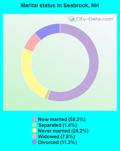
- Never married: 24.2%
- Now married: 55.3%
- Separated: 1.4%
- Widowed: 7.8%
- Divorced: 11.3%
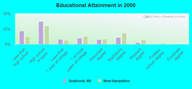
For population 25 years and over in Seabrook:
- High school or higher: 78.3%
- Bachelor's degree or higher: 14.8%
- Graduate or professional degree: 3.6%
- Unemployed: 2.5%
- Mean travel time to work (commute): 22.8 minutes
| Here: | 9.9 |
| New Hampshire average: | 10.9 |


Graphs represent county-level data. Detailed 2008 Election Results
Religion statistics for Seabrook, NH (based on Rockingham County data)


| Religion | Adherents | Congregations |
|---|---|---|
| Catholic | 84,697 | 24 |
| Mainline Protestant | 19,072 | 78 |
| Evangelical Protestant | 7,456 | 61 |
| Other | 3,490 | 20 |
| Orthodox | 200 | 1 |
| None | 180,308 | - |
Food Environment Statistics:
| Rockingham County: | 1.59 / 10,000 pop. |
| New Hampshire: | 2.14 / 10,000 pop. |
| Rockingham County: | 0.17 / 10,000 pop. |
| New Hampshire: | 0.15 / 10,000 pop. |
| Rockingham County: | 1.86 / 10,000 pop. |
| State: | 1.78 / 10,000 pop. |
| Rockingham County: | 3.31 / 10,000 pop. |
| State: | 4.02 / 10,000 pop. |
| This county: | 9.56 / 10,000 pop. |
| New Hampshire: | 9.70 / 10,000 pop. |
| Rockingham County: | 7.6% |
| New Hampshire: | 7.6% |
| Rockingham County: | 23.3% |
| New Hampshire: | 24.4% |
| This county: | 16.8% |
| New Hampshire: | 15.9% |
7.69% of this county's 2021 resident taxpayers lived in other counties in 2020 ($114,534 average adjusted gross income)
| Here: | 7.69% |
| New Hampshire average: | 7.66% |
0.01% of residents moved from foreign countries ($203 average AGI)
Rockingham County: 0.01% New Hampshire average: 0.01%
Top counties from which taxpayers relocated into this county between 2020 and 2021:
| from Essex County, MA | |
| from Hillsborough County, NH | |
| from Middlesex County, MA |
6.82% of this county's 2020 resident taxpayers moved to other counties in 2021 ($88,778 average adjusted gross income)
| Here: | 6.82% |
| New Hampshire average: | 6.80% |
0.01% of residents moved to foreign countries ($126 average AGI)
Rockingham County: 0.01% New Hampshire average: 0.01%
Top counties to which taxpayers relocated from this county between 2020 and 2021:
| to Hillsborough County, NH | |
| to Strafford County, NH | |
| to Essex County, MA |
| Businesses in Seabrook, NH | ||||
| Name | Count | Name | Count | |
|---|---|---|---|---|
| Advance Auto Parts | 1 | MasterBrand Cabinets | 2 | |
| Applebee's | 1 | McDonald's | 1 | |
| AutoZone | 1 | Nike | 1 | |
| Bath & Body Works | 1 | Payless | 1 | |
| Best Western | 1 | Pizza Hut | 1 | |
| Blockbuster | 1 | RadioShack | 1 | |
| CVS | 1 | Sam's Club | 1 | |
| Circle K | 1 | Sears | 1 | |
| Decora Cabinetry | 2 | Shaw's | 1 | |
| Dunkin Donuts | 3 | Sprint Nextel | 1 | |
| Famous Footwear | 1 | Staples | 1 | |
| FedEx | 3 | Starbucks | 1 | |
| GNC | 1 | Subway | 2 | |
| GameStop | 1 | T-Mobile | 2 | |
| Holiday Inn | 1 | T.J.Maxx | 1 | |
| Home Depot | 1 | Taco Bell | 1 | |
| KFC | 1 | U-Haul | 1 | |
| Kohl's | 1 | UPS | 3 | |
| Lane Furniture | 1 | Walmart | 1 | |
| Lowe's | 1 | Wendy's | 1 | |
Strongest AM radio stations in Seabrook:
- WRKO (680 AM; 50 kW; BOSTON, MA; Owner: ENTERCOM BOSTON LICENSE, LLC)
- WGIP (1540 AM; 5 kW; EXETER, NH; Owner: CAPSTAR TX LIMITED PARTNERSHIP)
- WNBP (1450 AM; 1 kW; NEWBURYPORT, MA; Owner: RADIO NEWBURYPORT, LLC)
- WBZ (1030 AM; 50 kW; BOSTON, MA; Owner: INFINITY BROADCASTING OPERATIONS, INC.)
- WEEI (850 AM; 50 kW; BOSTON, MA; Owner: ENTERCOM BOSTON LICENSE, LLC)
- WWZN (1510 AM; 50 kW; BOSTON, MA; Owner: ROSE CITY RADIO CORPORATION)
- WKOX (1200 AM; 50 kW; FRAMINGHAM, MA; Owner: CAPSTAR TX LIMITED PARTNERSHIP)
- WDER (1320 AM; 10 kW; DERRY, NH; Owner: BLOUNT COMMUNICATIONS, INC. OF NH)
- WBIX (1060 AM; 40 kW; NATICK, MA; Owner: LANGER BROADCASTING CORPORATION)
- WGIN (930 AM; 10 kW; ROCHESTER, NH; Owner: CAPSTAR TX LIMITED PARTNERSHIP)
- WCRN (830 AM; 50 kW; WORCESTER, MA; Owner: CARTER BROADCASTING CORPORATION)
- WRCA (1330 AM; 25 kW; WALTHAM, MA; Owner: WRCA LICENSE, LLC)
- WAMG (890 AM; 25 kW; DEDHAM, MA; Owner: MEGA COMMUNICATIONS OF DEDHAM LICENSEE, LLC)
Strongest FM radio stations in Seabrook:
- WSAK (102.1 FM; HAMPTON, NH; Owner: CITADEL BROADCASTING COMPANY)
- WNEF (91.7 FM; NEWBURYPORT, MA; Owner: UNIVERSITY OF MASSACHUSETTS)
- WXRV (92.5 FM; HAVERHILL, MA; Owner: BEANPOT BROADCASTING CORP.)
- WERZ (107.1 FM; EXETER, NH; Owner: CAPSTAR TX LIMITED PARTNERSHIP)
- WHEB (100.3 FM; PORTSMOUTH, NH; Owner: CAPSTAR TX LIMITED PARTNERSHIP)
- WKLB-FM (99.5 FM; LOWELL, MA; Owner: GREATER BOSTON RADIO, INC.)
- WUBB (95.3 FM; YORK CENTER, ME; Owner: CAPSTAR TX LIMITED PARTNERSHIP)
- WXKS-FM (107.9 FM; MEDFORD, MA; Owner: AMFM RADIO LICENSES, L.L.C.)
- WMJX (106.7 FM; BOSTON, MA; Owner: GREATER BOSTON RADIO, INC.)
- WQSX (93.7 FM; LAWRENCE, MA; Owner: ENTERCOM BOSTON LICENSE, LLC)
- WGIR-FM (101.1 FM; MANCHESTER, NH; Owner: CAPSTAR TX LIMITED PARTNERSHIP)
- W227AM (93.3 FM; ANDOVER, MA; Owner: GREATER BOSTON RADIO, INC.)
- WQLL (96.5 FM; BEDFORD, NH; Owner: SAGA COMMUNICATIONS OF NEW ENGLAND, LLC)
- WBMX (98.5 FM; BOSTON, MA; Owner: INFINITY RADIO OPERATIONS INC.)
- WBOQ (104.9 FM; GLOUCESTER, MA; Owner: MARLIN BROADCASTING, LLC)
- WLMW (90.7 FM; MANCHESTER, NH; Owner: KNOWLEDGE FOR LIFE)
- WJMN (94.5 FM; BOSTON, MA; Owner: AMFM RADIO LICENSES, L.L.C.)
- WCRB (102.5 FM; WALTHAM, MA; Owner: CHARLES RIVER BROADCASTING WCRB LICE)
- WTKK (96.9 FM; BOSTON, MA; Owner: GREATER BOSTON RADIO, INC.)
- WBOS (92.9 FM; BROOKLINE, MA; Owner: GREATER BOSTON RADIO, INC.)
TV broadcast stations around Seabrook:
- WHDN-LP (Channel 26; BOSTON, MA; Owner: GUENTER MARKSTEINER)
- WFXZ-CA (Channel 24; BOSTON, MA; Owner: BOSTON BROADCASTING CORP.)
- WMEA-TV (Channel 26; BIDDEFORD, ME; Owner: MAINE PUBLIC BROADCASTING CORP.)
- WCVB-TV (Channel 5; BOSTON, MA; Owner: WCVB HEARST-ARGYLE TV, INC.)
- WGBH-TV (Channel 2; BOSTON, MA; Owner: WGBH EDUCATIONAL FOUNDATION)
- WHDH-TV (Channel 7; BOSTON, MA; Owner: WHDH-TV)
- WMFP (Channel 62; LAWRENCE, MA; Owner: WSAH LICENSE, INC.)
- WSBK-TV (Channel 38; BOSTON, MA; Owner: VIACOM INC.)
- WLVI-TV (Channel 56; CAMBRIDGE, MA; Owner: WLVI, INC.)
- WBZ-TV (Channel 4; BOSTON, MA; Owner: VIACOM INC.)
- WGBX-TV (Channel 44; BOSTON, MA; Owner: WGBH EDUCATIONAL FOUNDATION)
- WBPX (Channel 68; BOSTON, MA; Owner: PAXSON BOSTON-68 LICENSE, INC.)
- WFXT (Channel 25; BOSTON, MA; Owner: FOX TELEVISION STATIONS INC.)
- WUTF (Channel 66; MARLBOROUGH, MA; Owner: TELEFUTURA BOSTON LLC)
- WENH-TV (Channel 11; DURHAM, NH; Owner: UNIVERSITY OF NEW HAMPSHIRE)
- WTMU-LP (Channel 32; BOSTON, MA; Owner: ZGS BOSTON, INC.)
- WCEA-LP (Channel 58; BOSTON, MA; Owner: CHANNEL 19 TV CORPORATION)
- WNDS (Channel 50; DERRY, NH; Owner: CTV OF DERRY, INC)

- National Bridge Inventory (NBI) Statistics
- 5Number of bridges
- 39ft / 12.3mTotal length
- $12,568,000Total costs
- 129,083Total average daily traffic
- 8,482Total average daily truck traffic
FCC Registered Antenna Towers:
18 (See the full list of FCC Registered Antenna Towers in Seabrook)FCC Registered Private Land Mobile Towers:
5 (See the full list of FCC Registered Private Land Mobile Towers in Seabrook, NH)FCC Registered Broadcast Land Mobile Towers:
26 (See the full list of FCC Registered Broadcast Land Mobile Towers)FCC Registered Microwave Towers:
2- SEABROOK, 11 Batchelder Rd (Lat: 42.892000 Lon: -70.882056), Type: Mast, Structure height: 77.1 m, Overall height: 77.4 m, Call Sign: WPTY892,
Assigned Frequencies: 10592.5 MHz, Grant Date: 12/13/2011, Expiration Date: 01/15/2022, Cancellation Date: 12/29/2015, Certifier: Carol L Tacker, Registrant: At&t Mobility LLC, 1120 20th Street, Nw - Suite 1000, Washington, DC 20036, Phone: (202) 457-2055, Fax: (202) 457-3073, Email:
- SEABROOK, No. 1 Turbine House, Seabrook Generating Station Rt 1 (Lat: 42.899528 Lon: -70.850333), Type: Tower, Structure height: 39 m, Overall height: 44.5 m, Call Sign: WEG750,
Assigned Frequencies: 6063.80 MHz, Grant Date: 06/04/2009, Expiration Date: 06/24/2019, Cancellation Date: 06/25/2014, Certifier: Tim Lewis, Registrant: Florida Power & Light Company, 9250 West Flagler St., Miami, FL 33174, Phone: (305) 552-4041, Email:
FCC Registered Paging Towers:
2- Seabrook Nuclear Plant (Lat: 42.897028 Lon: -70.853639), Call Sign: KCI295,
Assigned Frequencies: 43.5600 MHz, Grant Date: 05/11/1999, Expiration Date: 04/01/2009, Cancellation Date: 12/02/2003, Certifier: Paul H Kuzia, Registrant: Wilkinson Barker Knauer, LLP, 2300 N Street, N.W., 7th Floor, Washington, DC 20037, Phone: (202) 783-4141, Fax: (202) 783-5851, Email:
- Seabrook Nuclear Power Plant (Lat: 42.897583 Lon: -70.853639), Type: Tower, Structure height: 30.8 m, Call Sign: KNKG819, Licensee ID: L01422065,
Assigned Frequencies: 931.862 MHz, Grant Date: 08/12/2008, Expiration Date: 07/01/2018, Cancellation Date: 01/28/2014, Certifier: Shawn E Endsley, Registrant: Usa Mobility Wireless, Inc., 3000 Technology Dr. #400, Plano, TX 75074, Phone: (972) 801-0000, Fax: (972) 801-1699, Email:
FCC Registered Maritime Coast & Aviation Ground Towers:
1- 48 B River St (Lat: 43.885361 Lon: -70.818944), Type: Building, Overall height: 4 m, Call Sign: WHU505,
Assigned Frequencies: 156.425 MHz, 156.450 MHz, 156.800 MHz, Grant Date: 11/16/1993, Expiration Date: 11/16/1998, Cancellation Date: 05/06/2001, Registrant: Eastmans Fishing & Marine Industries Inc, 48 B River St, Seabrook, NH 03874
FCC Registered Amateur Radio Licenses:
57 (See the full list of FCC Registered Amateur Radio Licenses in Seabrook)FAA Registered Aircraft Manufacturers and Dealers:
1 (See the full list of FAA Registered Manufacturers and Dealers in Seabrook)FAA Registered Aircraft:
9 (See the full list of FAA Registered Aircraft)2004 - 2018 National Fire Incident Reporting System (NFIRS) incidents
- Fire incident types reported to NFIRS in Seabrook, NH
- 10938.7%Structure Fires
- 9634.0%Outside Fires
- 5218.4%Other
- 258.9%Mobile Property/Vehicle Fires
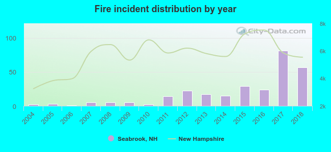 Based on the data from the years 2004 - 2018 the average number of fires per year is 19. The highest number of reported fire incidents - 81 took place in 2017, and the least - 1 in 2006. The data has a growing trend.
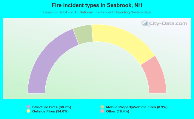 When looking into fire subcategories, the most reports belonged to: Structure Fires (38.7%), and Outside Fires (34.0%).
Fire-safe hotels and motels in Seabrook, New Hampshire:
- Hampshire Inn, 20 Spur Rd, Seabrook, New Hampshire 03874 , Phone: (603) 474-5700, Fax: (603) 474-2886
- Holiday Inn Express, 11 Rocks Rd, Seabrook, New Hampshire 03874 , Phone: (603) 474-1150, Fax: (603) 474-2002

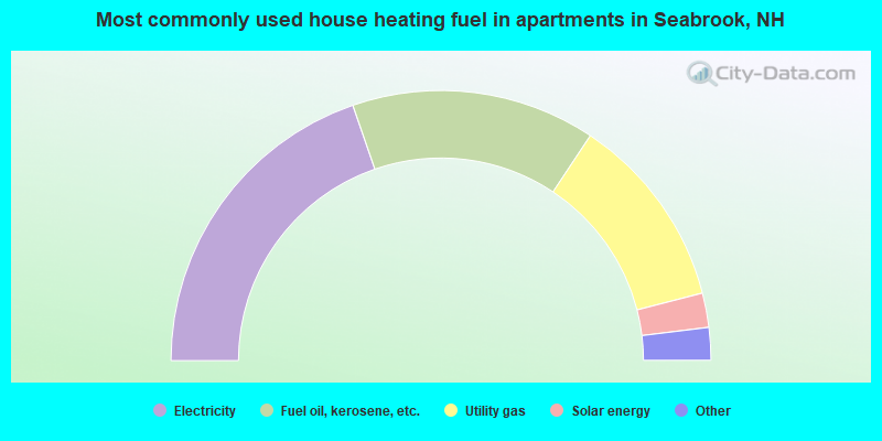
- 55.0%Fuel oil, kerosene, etc.
- 35.7%Utility gas
- 4.5%Bottled, tank, or LP gas
- 4.1%Electricity
- 0.6%Wood
- 39.4%Electricity
- 29.2%Fuel oil, kerosene, etc.
- 23.3%Utility gas
- 4.1%Solar energy
- 1.7%Bottled, tank, or LP gas
- 1.4%Other fuel
- 0.8%Wood
Seabrook compared to New Hampshire state average:
- Unemployed percentage significantly below state average.
- Black race population percentage below state average.
- Hispanic race population percentage below state average.
- Foreign-born population percentage significantly below state average.
- Length of stay since moving in significantly above state average.
- Number of rooms per house significantly below state average.
- House age significantly below state average.
- Percentage of population with a bachelor's degree or higher below state average.
Seabrook on our top lists:
- #14 on the list of "Top 101 cities with largest percentage of females in industries: petroleum and petroleum products merchant wholesalers (population 5,000+)"
- #15 on the list of "Top 101 cities with largest percentage of males in occupations: cooks and food preparation workers (population 5,000+)"
- #21 on the list of "Top 101 cities with largest percentage of females in industries: department and other general merchandise stores (population 5,000+)"
- #25 on the list of "Top 101 cities with largest percentage of females in occupations: laborers and material movers, hand (population 5,000+)"
- #31 on the list of "Top 101 cities with largest percentage of males in occupations: supervisors and other personal care and service workers except personal appearance, transportation, and child care workers (population 5,000+)"
- #38 on the list of "Top 101 cities with largest percentage of females in industries: clothing and accessories, including shoe, stores (population 5,000+)"
- #41 on the list of "Top 101 cities with largest percentage of females in industries: electrical equipment, appliances, and components (population 5,000+)"
- #41 on the list of "Top 101 cities with largest percentage of females in industries: used merchandise, gift, novelty, and souvenir, and other miscellaneous stores (population 5,000+)"
- #51 on the list of "Top 101 cities with largest percentage of males in industries: groceries and related products merchant wholesalers (population 5,000+)"
- #55 on the list of "Top 101 cities with largest percentage of males in industries: music stores (population 5,000+)"
- #60 on the list of "Top 101 cities with largest percentage of females in occupations: assemblers and fabricators (population 5,000+)"
- #62 on the list of "Top 101 cities with largest percentage of males in occupations: special education teachers (population 5,000+)"
- #64 on the list of "Top 101 cities with largest percentage of females in industries: sewing, needlework, and piece goods stores (population 5,000+)"
- #68 on the list of "Top 101 cities with largest percentage of females in industries: furniture and home furnishing merchant wholesalers (population 5,000+)"
- #82 on the list of "Top 101 cities with largest percentage of females in occupations: occupational and physical therapist assistants and aides (population 5,000+)"
- #99 on the list of "Top 101 cities with largest percentage of males in industries: furniture and home furnishing merchant wholesalers (population 5,000+)"
- #9 on the list of "Top 101 counties with the largest decrease in the number of births per 1000 residents 2000-2006 to 2007-2013 (pop 50,000+)"
- #14 on the list of "Top 101 counties with the best general health status score of residents (1-5), 3 years of data"
- #16 on the list of "Top 101 counties with the lowest number of births per 1000 residents 2007-2013"
- #22 on the list of "Top 101 counties with the lowest Particulate Matter (PM10) Annual air pollution readings in 2012 (µg/m3)"
- #36 on the list of "Top 101 counties with the highest percentage of residents that visited a dentist within the past year"

|
|
Total of 86 patent applications in 2008-2024.