Seymour Rural, Texas
Submit your own pictures of this place and show them to the world
- OSM Map
- General Map
- Google Map
- MSN Map

| Males: 403 | |
| Females: 375 |
| Median resident age: | 46.6 years |
| Texas median age: | 32.3 years |
Zip code: 76380
| Seymour Rural: | $65,322 |
| TX: | $72,284 |
Estimated per capita income in 2022: $31,604 (it was $16,231 in 2000)
Seymour Rural CCD income, earnings, and wages data
Estimated median house or condo value in 2022: $116,573 (it was $40,800 in 2000)
| Seymour Rural: | $116,573 |
| TX: | $275,400 |
Mean prices in 2022: all housing units: $162,247; detached houses: $163,536; mobile homes: $92,053
Detailed information about poverty and poor residents in Seymour Rural, TX
Compare current foreclosures near Seymour Rural, TX:
| Photo | Address | Area | Beds / Baths | Price | Details |
|---|---|---|---|---|---|

|
#1
N Cedar St
Seymour, TX 76380
|
1 sq. feet
|
1 baths 2 beds |
show details | |

|
#2
County Road 204
Seymour, TX 76380
|
- sq. feet
|
- baths - beds |
show details | |

|
Check over 1 million property listings on Foreclosure.com!
|
browse all offers | |||

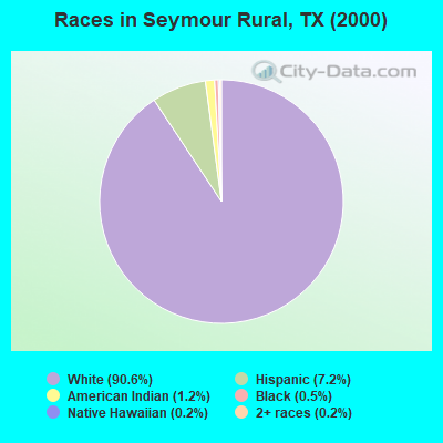
- 74690.6%White alone
- 597.2%Hispanic
- 101.2%American Indian alone
- 40.5%Black alone
- 20.2%Native Hawaiian and Other
Pacific Islander alone - 20.2%Two or more races
Races in Seymour Rural detailed stats: ancestries, foreign born residents, place of birth
 Recent articles from our blog. Our writers, many of them Ph.D. graduates or candidates, create easy-to-read articles on a wide variety of topics.
Current Local Time: CST time zone
Land area: 827.7 square miles.
Population density: 0.9 people per square mile (very low).

| Seymour Rural CCD: | 0.9% ($377) |
| Texas: | 1.8% ($1,393) |
Nearest city with pop. 50,000+: Wichita Falls, TX  (46.7 miles , pop. 104,197).
Nearest city with pop. 200,000+: Fort Worth, TX (127.6 miles , pop. 534,694).
Nearest city with pop. 1,000,000+: Dallas, TX (154.4 miles , pop. 1,188,580).
Nearest cities:
), ), ), ), ), ), Latitude: 33.63 N, Longitude: 99.26 W
Area code commonly used in this area: 940

| Here: | 1.9% |
| Texas: | 3.5% |
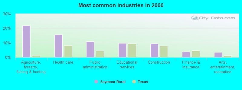
- Agriculture, forestry, fishing & hunting (22.0%)
- Health care (15.7%)
- Public administration (11.0%)
- Educational services (9.8%)
- Construction (9.5%)
- Finance & insurance (3.9%)
- Arts, entertainment, recreation (3.6%)
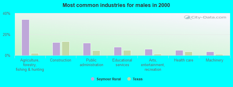
- Agriculture, forestry, fishing & hunting (34.3%)
- Construction (12.4%)
- Public administration (11.9%)
- Educational services (8.0%)
- Arts, entertainment, recreation (6.0%)
- Health care (5.0%)
- Machinery (3.5%)
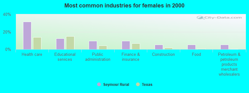
- Health care (31.6%)
- Educational services (12.5%)
- Public administration (9.6%)
- Finance & insurance (9.6%)
- Construction (5.1%)
- Food (5.1%)
- Petroleum & petroleum products merchant wholesalers (5.1%)
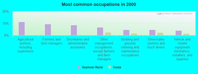
- Agricultural workers, including supervisors (11.3%)
- Farmers and farm managers (9.5%)
- Secretaries and administrative assistants (8.6%)
- Other management occupations, except farmers and farm managers (6.8%)
- Building and grounds cleaning and maintenance occupations (4.7%)
- Driver/sales workers and truck drivers (4.7%)
- Vehicle and mobile equipment mechanics, installers, and repairers (4.2%)
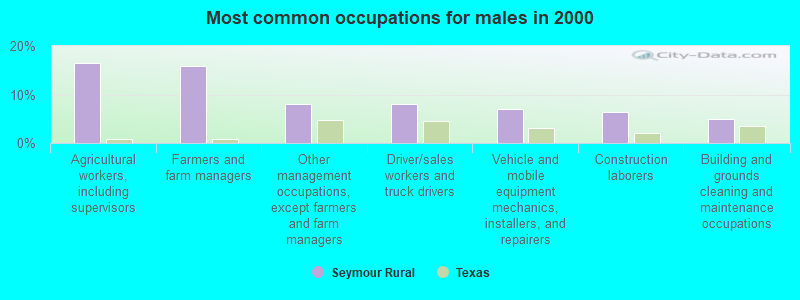
- Agricultural workers, including supervisors (16.4%)
- Farmers and farm managers (15.9%)
- Other management occupations, except farmers and farm managers (8.0%)
- Driver/sales workers and truck drivers (8.0%)
- Vehicle and mobile equipment mechanics, installers, and repairers (7.0%)
- Construction laborers (6.5%)
- Building and grounds cleaning and maintenance occupations (5.0%)
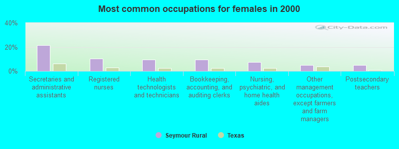
- Secretaries and administrative assistants (21.3%)
- Registered nurses (10.3%)
- Health technologists and technicians (9.6%)
- Bookkeeping, accounting, and auditing clerks (9.6%)
- Nursing, psychiatric, and home health aides (7.4%)
- Other management occupations, except farmers and farm managers (5.1%)
- Postsecondary teachers (5.1%)
Average climate in Seymour Rural, Texas
Based on data reported by over 4,000 weather stations


Tornado activity:
Seymour Rural-area historical tornado activity is slightly above Texas state average. It is 65% greater than the overall U.S. average.
On 4/2/1980, a category F4 (max. wind speeds 207-260 mph) tornado 5.3 miles away from the Seymour Rural place center .
On 5/18/1951, a category F4 tornado 33.0 miles away from the place center killed 2 people and injured 100 people and caused between $500,000 and $5,000,000 in damages.
Earthquake activity:
Seymour Rural-area historical earthquake activity is significantly above Texas state average. It is 534% greater than the overall U.S. average.On 6/16/1978 at 11:46:54, a magnitude 5.3 (4.4 MB, 4.6 UK, 5.3 ML, Class: Moderate, Intensity: VI - VII) earthquake occurred 96.4 miles away from the city center
On 11/6/2011 at 03:53:10, a magnitude 5.7 (5.7 MW, Depth: 3.2 mi) earthquake occurred 193.5 miles away from the city center
On 9/3/2016 at 12:02:44, a magnitude 5.8 (5.8 MW, Depth: 3.5 mi) earthquake occurred 233.9 miles away from Seymour Rural center
On 2/13/2016 at 17:07:06, a magnitude 5.1 (5.1 MW, Depth: 5.2 mi) earthquake occurred 200.0 miles away from the city center
On 4/14/1995 at 00:32:56, a magnitude 5.7 (5.6 MB, 5.7 MS, 5.7 MW, Depth: 11.1 mi) earthquake occurred 334.4 miles away from the city center
On 11/7/2016 at 01:44:24, a magnitude 5.0 (5.0 MW, Depth: 2.8 mi) earthquake occurred 214.7 miles away from the city center
Magnitude types: body-wave magnitude (MB), local magnitude (ML), surface-wave magnitude (MS), moment magnitude (MW)
Natural disasters:
The number of natural disasters in Baylor County (12) is smaller than the US average (15).Major Disasters (Presidential) Declared: 5
Emergencies Declared: 5
Causes of natural disasters: Storms: 5, Floods: 4, Tornadoes: 4, Fires: 3, Hurricanes: 3, Wind: 1, Other: 1 (Note: some incidents may be assigned to more than one category).
Hospitals and medical centers near Seymour Rural:
- SEYMOUR REHABILITATION AND HEALTHCARE (Nursing Home, about 3 miles away; SEYMOUR, TX)
- WESTVIEW CARE CENTER (Nursing Home, about 3 miles away; SEYMOUR, TX)
- SEYMOUR HOSPITAL Acute Care Hospitals (about 3 miles away; SEYMOUR, TX)
- SEYMOUR HOSPITAL HOME HEALTH (Home Health Center, about 3 miles away; SEYMOUR, TX)
- INTEGRACARE OF SEYMOUR (Home Health Center, about 4 miles away; SEYMOUR, TX)
Colleges/universities with over 2000 students nearest to Seymour Rural:
- Vernon College (about 37 miles; Vernon, TX; Full-time enrollment: 2,216)
- Midwestern State University (about 47 miles; Wichita Falls, TX; FT enrollment: 4,901)
- Western Oklahoma State College (about 72 miles; Altus, OK; FT enrollment: 2,054)
- Cameron University (about 83 miles; Lawton, OK; FT enrollment: 4,695)
- Abilene Christian University (about 85 miles; Abilene, TX; FT enrollment: 4,025)
- Cisco College (about 87 miles; Cisco, TX; FT enrollment: 2,687)
- Weatherford College (about 106 miles; Weatherford, TX; FT enrollment: 4,080)
Points of interest:
Notable locations in Seymour Rural: Indian Creek Pens (A), Jones Cow Camp (B), La Paloma Cow Camp (C), Sweet La Cruz Cow Camp (D), Boone Ranch (E), Seymour Country Club (F), Seymour Downs Race Track (G), Seymour - Baylor County Volunteer Fire Department (H), Seymour - Baylor County Emergency Medical Services (I). Display/hide their locations on the map
Churches in Seymour Rural include: New Covenant Church (A), Trinity Luthern Church (B), Church of Christ (C), New Mount Zion Baptist Church (D), First Baptist Church (E). Display/hide their locations on the map
Cemeteries: England Cemetery (1), Round Timber Cemetery (2), Woodman Cemetery (3), Henson Cemetery (4), Cache Creek Cemetery (5), Bomarton Cemetery (6), Riverview Cemetery (7). Display/hide their locations on the map
Lakes and reservoirs: Lost Lake (A), Waggoner Lake Number 1 (B), Waggoner Lake Number 2 (C), Waggoner Lake Number 3 (D), Waggoner Lake Number 4 (E), Waggoner Lake Number 5 (F), Waggoner Lake Number 6 (G), Porter Lake (H). Display/hide their locations on the map
Streams, rivers, and creeks: Turkey Creek (A), Boggy Creek (B), Big Moonshine Creek (C), Aytes Branch (D), Antelope Creek (E), Wagon Creek (F), Yokum Creek (G), Seymour Creek (H), Soap Creek (I). Display/hide their locations on the map
Park in Seymour Rural: Seymour City Park (1). Display/hide its location on the map
| This place: | 2.1 people |
| Texas: | 2.8 people |
| This place: | 64.7% |
| Whole state: | 69.9% |
| This place: | 4.0% |
| Whole state: | 6.0% |
No gay or lesbian households reported
| This place: | 4.2% |
| Whole state: | 15.4% |
| This place: | 3.6% |
| Whole state: | 6.7% |
For population 15 years and over in Seymour Rural:
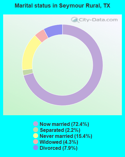
- Never married: 15.4%
- Now married: 72.4%
- Separated: 2.2%
- Widowed: 4.3%
- Divorced: 7.9%
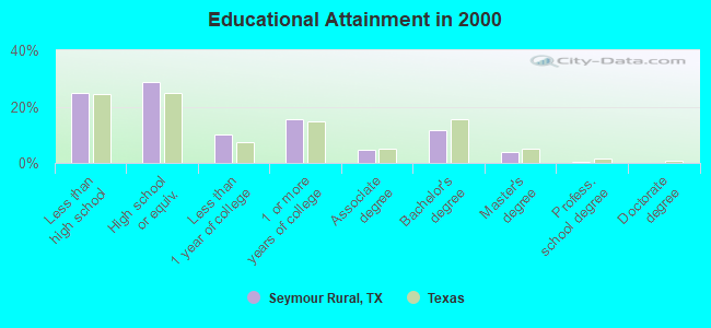
For population 25 years and over in Seymour Rural:
- High school or higher: 75.3%
- Bachelor's degree or higher: 16.3%
- Graduate or professional degree: 4.5%
- Unemployed: 5.3%
- Mean travel time to work (commute): 20.8 minutes
| Here: | 11.3 |
| Texas average: | 15.6 |
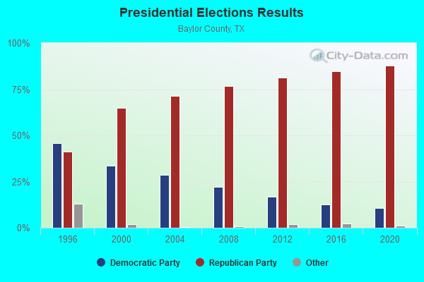
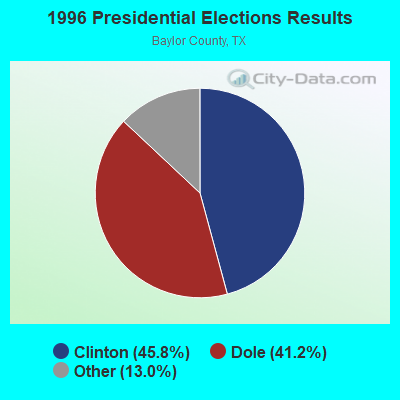
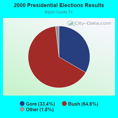
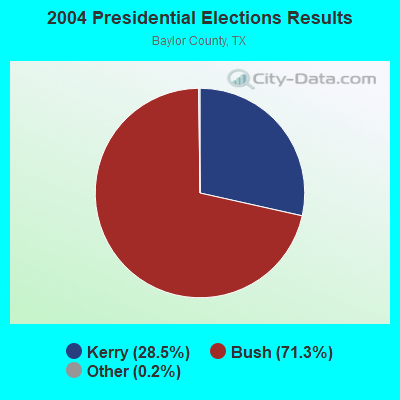
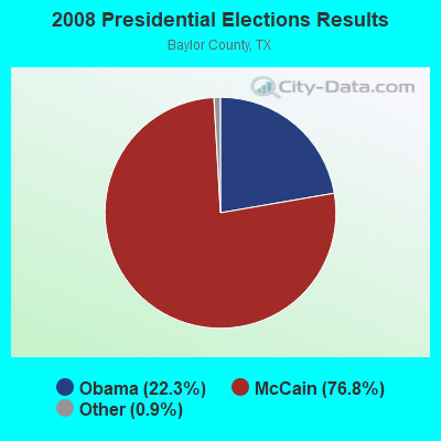
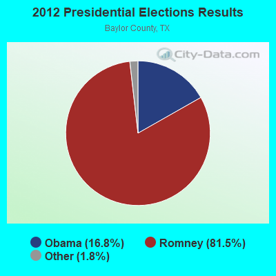
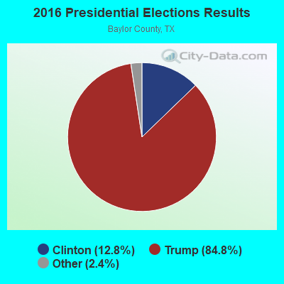

Graphs represent county-level data. Detailed 2008 Election Results
Religion statistics for Seymour Rural, TX (based on Baylor County data)
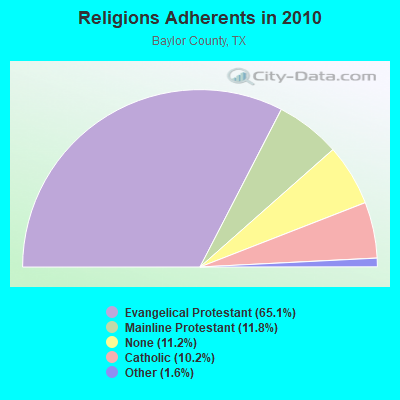

| Religion | Adherents | Congregations |
|---|---|---|
| Evangelical Protestant | 2,426 | 11 |
| Mainline Protestant | 440 | 2 |
| Catholic | 380 | 1 |
| Other | 61 | 1 |
| None | 419 | - |
Food Environment Statistics:
| This county: | 2.60 / 10,000 pop. |
| Texas: | 1.47 / 10,000 pop. |
| This county: | 12.99 / 10,000 pop. |
| Texas: | 3.95 / 10,000 pop. |
| Baylor County: | 5.20 / 10,000 pop. |
| Texas: | 6.13 / 10,000 pop. |
| Here: | 11.0% |
| Texas: | 8.9% |
| Here: | 27.0% |
| Texas: | 26.6% |
| Baylor County: | 14.6% |
| State: | 15.7% |
Strongest AM radio stations in Seymour Rural:
- KSEY (1230 AM; 1 kW; SEYMOUR, TX; Owner: MARK V. AULABAUGH)
- KCAF (990 AM; 10 kW; FARMERSVILLE, TX; Owner: RENAISSANCE RADIO, INC.)
- WBAP (820 AM; 50 kW; FORT WORTH, TX; Owner: WBAP-KSCS OPERATING, LTD.)
- KAHZ (1360 AM; 50 kW; HURST, TX)
- KESS (1270 AM; 50 kW; FORT WORTH, TX; Owner: KESS-AM LICENSE CORP.)
- KWFS (1290 AM; 5 kW; WICHITA FALLS, TX; Owner: CCB TEXAS LICENSES, L.P.)
- KRLD (1080 AM; 50 kW; DALLAS, TX; Owner: TEXAS INFINITY BROADCASTING L.P.)
- KZMP (1540 AM; 50 kW; UNIVERSITY PARK, TX; Owner: ENTRAVISION HOLDINGS, LLC)
- KFXR (1190 AM; 50 kW; DALLAS, TX; Owner: CLEAR CHANNEL BROADCASTING LICENSES, INC.)
- KOMA (1520 AM; 50 kW; OKLAHOMA CITY, OK; Owner: RENDA BROADCASTING CORP. OF NEVADA)
- KRMG (740 AM; 50 kW; TULSA, OK; Owner: CXR HOLDINGS, INC.)
- KSKY (660 AM; 20 kW; BALCH SPRINGS, TX; Owner: BISON MEDIA, INC.)
- KBIS (1150 AM; 25 kW; HIGHLAND PARK, TX; Owner: DALLAS AM RADIO PARTNERS, L.P.)
Strongest FM radio stations in Seymour Rural:
- KSEY-FM (94.3 FM; SEYMOUR, TX; Owner: MARK V. AULABAUGH)
- KYYI (104.7 FM; BURKBURNETT, TX; Owner: CUMULUS LICENSING CORP.)
- KVRP-FM (97.1 FM; HASKELL, TX; Owner: ROLLING PLAINS BROADCASTING CORP.)
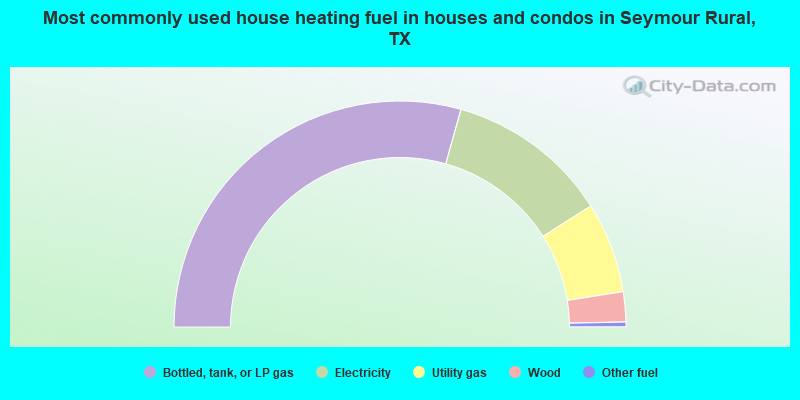
- 58.7%Bottled, tank, or LP gas
- 23.3%Electricity
- 13.0%Utility gas
- 4.3%Wood
- 0.7%Other fuel
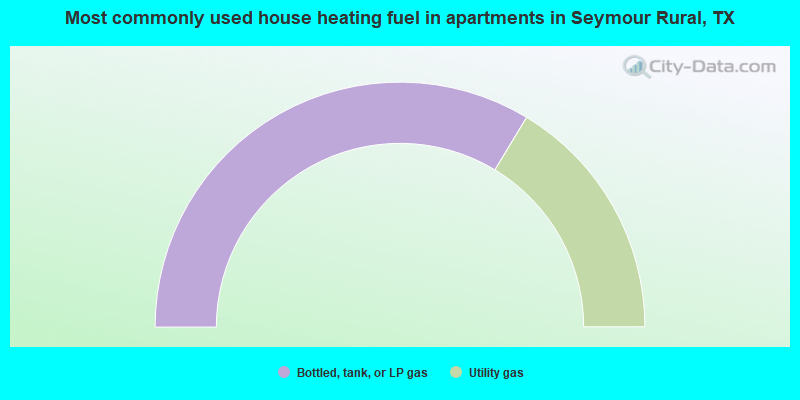
- 67.3%Bottled, tank, or LP gas
- 32.7%Utility gas
Seymour Rural compared to Texas state average:
- Median house value significantly below state average.
- Unemployed percentage below state average.
- Black race population percentage significantly below state average.
- Hispanic race population percentage significantly below state average.
- Median age significantly above state average.
- Foreign-born population percentage significantly below state average.
- Renting percentage below state average.
- Length of stay since moving in significantly above state average.
- Number of rooms per house significantly below state average.
- House age significantly below state average.