Shawangunk, New York
Submit your own pictures of this town and show them to the world
- OSM Map
- Google Map
- MSN Map
Population change since 2000: +19.2%
 |
| Males: 8,133 | |
| Females: 6,199 |
| Median resident age: | 38.7 years |
| New York median age: | 40.7 years |
Zip codes: 12589.
| Shawangunk: | $98,911 |
| NY: | $79,557 |
Estimated per capita income in 2022: $42,746 (it was $19,402 in 2000)
Shawangunk town income, earnings, and wages data
Estimated median house or condo value in 2022: $412,985 (it was $136,600 in 2000)
| Shawangunk: | $412,985 |
| NY: | $400,400 |
Mean prices in 2022: all housing units: $379,181; detached houses: $393,684; townhouses or other attached units: $652,719; in 2-unit structures: $266,147; in 3-to-4-unit structures: $293,759; in 5-or-more-unit structures: $291,039; mobile homes: $115,808
Detailed information about poverty and poor residents in Shawangunk, NY


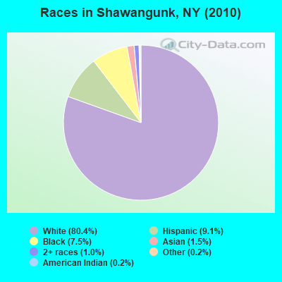
- 11,52280.4%White alone
- 1,3109.1%Hispanic
- 1,0787.5%Black alone
- 2221.5%Asian alone
- 1481.0%Two or more races
- 220.2%American Indian alone
- 300.2%Other race alone
Races in Shawangunk detailed stats: ancestries, foreign born residents, place of birth
Type |
2009 |
2010 |
2011 |
2012 |
2013 |
2014 |
2015 |
2016 |
2017 |
2018 |
2019 |
2020 |
2021 |
2022 |
|---|---|---|---|---|---|---|---|---|---|---|---|---|---|---|
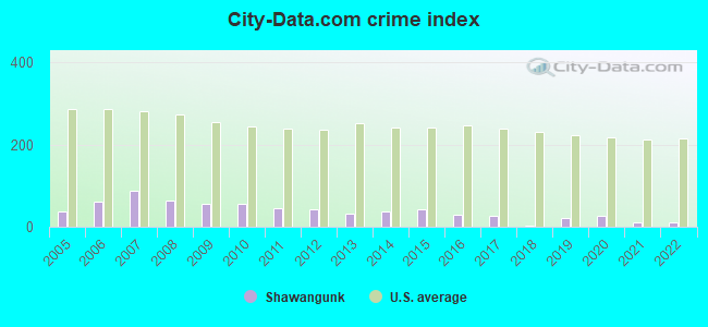
| Murders (per 100,000) | 0 (0.0) | 0 (0.0) | 0 (0.0) | 0 (0.0) | 0 (0.0) | 0 (0.0) | 0 (0.0) | 0 (0.0) | 0 (0.0) | 0 (0.0) | 0 (0.0) | 0 (0.0) | 0 (0.0) | 0 (0.0) |
| Rapes (per 100,000) | 0 (0.0) | 0 (0.0) | 0 (0.0) | 0 (0.0) | 0 (0.0) | 1 (7.1) | 1 (7.1) | 1 (7.1) | 0 (0.0) | 0 (0.0) | 1 (7.2) | 2 (14.5) | 0 (0.0) | 0 (0.0) |
| Robberies (per 100,000) | 0 (0.0) | 0 (0.0) | 0 (0.0) | 0 (0.0) | 0 (0.0) | 3 (21.2) | 0 (0.0) | 0 (0.0) | 0 (0.0) | 0 (0.0) | 0 (0.0) | 1 (7.3) | 0 (0.0) | 0 (0.0) |
| Assaults (per 100,000) | 13 (101.7) | 12 (83.7) | 6 (41.7) | 3 (20.8) | 3 (21.1) | 2 (14.1) | 5 (35.4) | 4 (28.4) | 2 (14.3) | 1 (7.2) | 1 (7.2) | 0 (0.0) | 3 (21.8) | 1 (7.3) |
| Burglaries (per 100,000) | 21 (164.2) | 26 (181.4) | 32 (222.3) | 29 (201.3) | 20 (140.8) | 20 (141.3) | 18 (127.3) | 9 (63.8) | 9 (64.2) | 2 (14.3) | 8 (57.7) | 6 (43.5) | 0 (0.0) | 6 (43.9) |
| Thefts (per 100,000) | 75 (586.6) | 93 (648.9) | 67 (465.4) | 86 (597.0) | 60 (422.4) | 47 (332.0) | 56 (396.2) | 42 (297.9) | 69 (492.2) | 1 (7.2) | 30 (216.6) | 31 (224.9) | 23 (167.3) | 19 (138.9) |
| Auto thefts (per 100,000) | 1 (7.8) | 2 (14.0) | 5 (34.7) | 1 (6.9) | 0 (0.0) | 0 (0.0) | 8 (56.6) | 3 (21.3) | 0 (0.0) | 0 (0.0) | 3 (21.7) | 2 (14.5) | 0 (0.0) | 0 (0.0) |
| Arson (per 100,000) | 1 (7.8) | 1 (7.0) | 0 (0.0) | 2 (13.9) | 0 (0.0) | 0 (0.0) | 0 (0.0) | 0 (0.0) | 1 (7.1) | 0 (0.0) | 0 (0.0) | 0 (0.0) | 0 (0.0) | 0 (0.0) |
| City-Data.com crime index | 55.9 | 56.5 | 45.3 | 42.7 | 31.0 | 38.0 | 42.0 | 29.4 | 27.0 | 2.7 | 21.7 | 27.0 | 11.1 | 10.1 |
The City-Data.com crime index weighs serious crimes and violent crimes more heavily. Higher means more crime, U.S. average is 246.1. It adjusts for the number of visitors and daily workers commuting into cities.
Crime rate in Shawangunk detailed stats: murders, rapes, robberies, assaults, burglaries, thefts, arson
Full-time law enforcement employees in 2021, including police officers: 6 (6 officers - 5 male; 1 female).
| Officers per 1,000 residents here: | 0.44 |
| New York average: | 3.28 |
 Recent articles from our blog. Our writers, many of them Ph.D. graduates or candidates, create easy-to-read articles on a wide variety of topics.
Ancestries: Irish (22.2%), German (18.7%), Italian (15.7%), English (10.2%), United States (4.8%), Dutch (4.4%).
Current Local Time: EST time zone
Land area: 56.2 square miles.
Population density: 255 people per square mile (very low).
528 residents are foreign born (1.7% Europe, 1.6% Latin America, 0.7% Asia).
| This town: | 4.4% |
| New York: | 20.4% |
| Shawangunk town: | 2.3% ($3,078) |
| New York: | 1.9% ($2,847) |
Nearest city with pop. 50,000+: Ramapo, NY  (35.1 miles , pop. 108,905).
Nearest city with pop. 200,000+: Bronx, NY (56.4 miles , pop. 1,332,650).
Nearest cities:
), ), ), )Latitude: 41.62 N, Longitude: 74.23 W
Area code commonly used in this area: 845
Shawangunk, New York accommodation & food services, waste management - Economy and Business Data
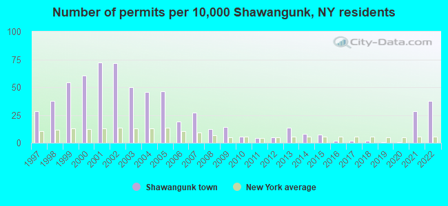
Single-family new house construction building permits:
- 2022: 45 buildings, average cost: $262,500
- 2021: 34 buildings, average cost: $262,500
- 2020: 1 building, cost: $225,000
- 2019: 1 building, cost: $225,000
- 2018: 2 buildings, average cost: $200,000
- 2017: 2 buildings, average cost: $200,000
- 2016: 2 buildings, average cost: $200,000
- 2015: 9 buildings, average cost: $262,000
- 2014: 10 buildings, average cost: $262,000
- 2013: 16 buildings, average cost: $225,600
- 2012: 6 buildings, average cost: $225,000
- 2011: 5 buildings, average cost: $218,000
- 2010: 7 buildings, average cost: $202,900
- 2009: 17 buildings, average cost: $179,300
- 2008: 15 buildings, average cost: $206,600
- 2007: 33 buildings, average cost: $240,900
- 2006: 23 buildings, average cost: $197,000
- 2005: 56 buildings, average cost: $186,400
- 2004: 55 buildings, average cost: $187,600
- 2003: 60 buildings, average cost: $170,700
- 2002: 86 buildings, average cost: $203,000
- 2001: 87 buildings, average cost: $165,900
- 2000: 73 buildings, average cost: $121,400
- 1999: 65 buildings, average cost: $128,100
- 1998: 45 buildings, average cost: $108,400
- 1997: 34 buildings, average cost: $118,400
| Here: | 3.9% |
| New York: | 4.4% |
- Educational services (11.1%)
- Public administration (8.5%)
- Construction (7.0%)
- Health care (6.1%)
- Professional, scientific, technical services (4.1%)
- Accommodation & food services (3.5%)
- Food & beverage stores (3.4%)
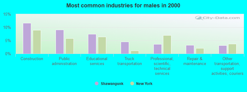
- Construction (11.6%)
- Public administration (9.1%)
- Educational services (7.5%)
- Truck transportation (4.6%)
- Professional, scientific, technical services (3.5%)
- Repair & maintenance (3.3%)
- Other transportation, support activities, couriers (3.1%)
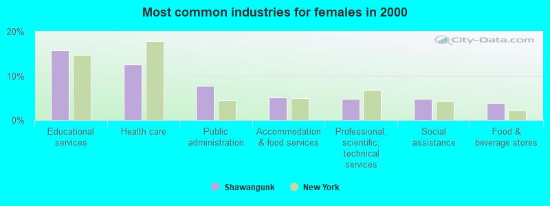
- Educational services (15.8%)
- Health care (12.6%)
- Public administration (7.8%)
- Accommodation & food services (5.1%)
- Professional, scientific, technical services (4.9%)
- Social assistance (4.8%)
- Food & beverage stores (3.9%)
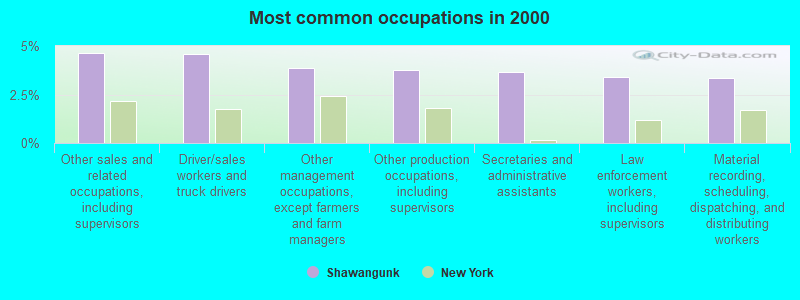
- Other sales and related occupations, including supervisors (4.6%)
- Driver/sales workers and truck drivers (4.6%)
- Other management occupations, except farmers and farm managers (3.9%)
- Other production occupations, including supervisors (3.8%)
- Secretaries and administrative assistants (3.6%)
- Law enforcement workers, including supervisors (3.4%)
- Material recording, scheduling, dispatching, and distributing workers (3.4%)
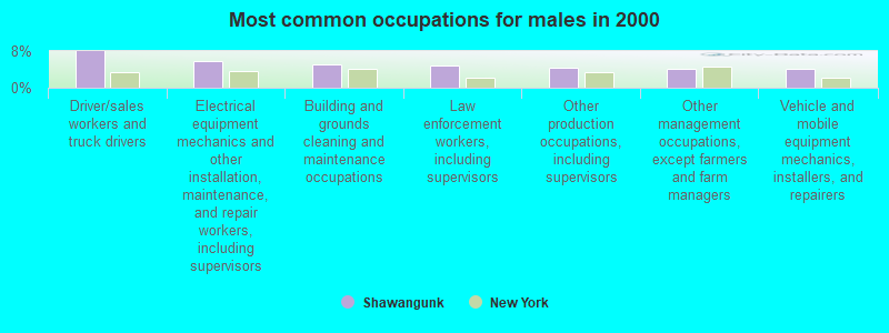
- Driver/sales workers and truck drivers (8.0%)
- Electrical equipment mechanics and other installation, maintenance, and repair workers, including supervisors (5.8%)
- Building and grounds cleaning and maintenance occupations (5.0%)
- Law enforcement workers, including supervisors (4.8%)
- Other production occupations, including supervisors (4.4%)
- Other management occupations, except farmers and farm managers (4.2%)
- Vehicle and mobile equipment mechanics, installers, and repairers (4.2%)
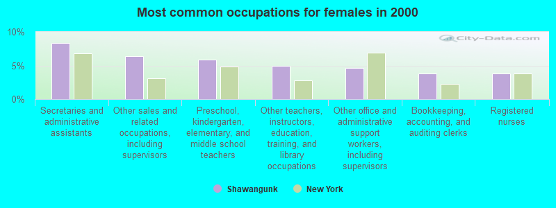
- Secretaries and administrative assistants (8.3%)
- Other sales and related occupations, including supervisors (6.4%)
- Preschool, kindergarten, elementary, and middle school teachers (5.8%)
- Other teachers, instructors, education, training, and library occupations (5.0%)
- Other office and administrative support workers, including supervisors (4.6%)
- Bookkeeping, accounting, and auditing clerks (3.8%)
- Registered nurses (3.8%)
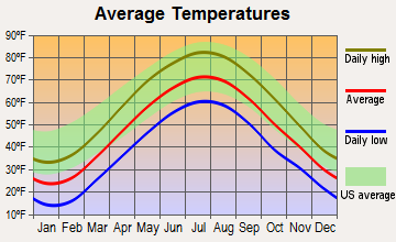
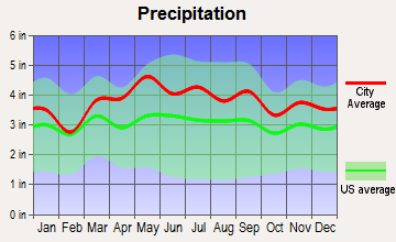
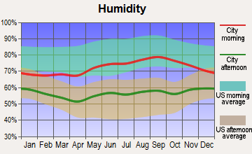
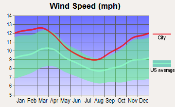
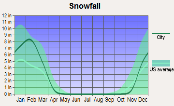
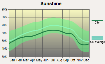
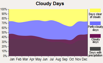
Average climate in Shawangunk, New York
Based on data reported by over 4,000 weather stations
(lower is better)
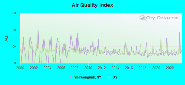
Air Quality Index (AQI) level in 2023 was 78.9. This is about average.
| City: | 78.9 |
| U.S.: | 72.6 |
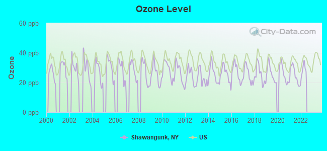
Ozone [ppb] level in 2021 was 24.9. This is better than average. Closest monitor was 6.5 miles away from the city center.
| City: | 24.9 |
| U.S.: | 33.3 |
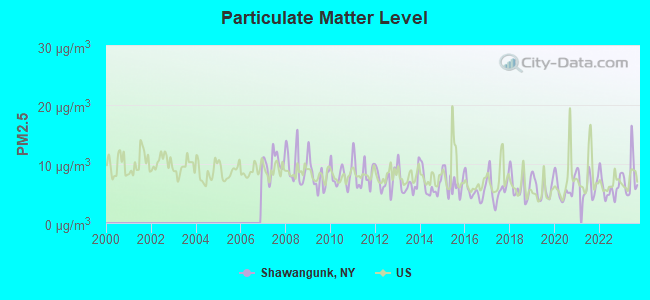
Particulate Matter (PM2.5) [µg/m3] level in 2023 was 7.85. This is about average. Closest monitor was 14.2 miles away from the city center.
| City: | 7.85 |
| U.S.: | 8.11 |
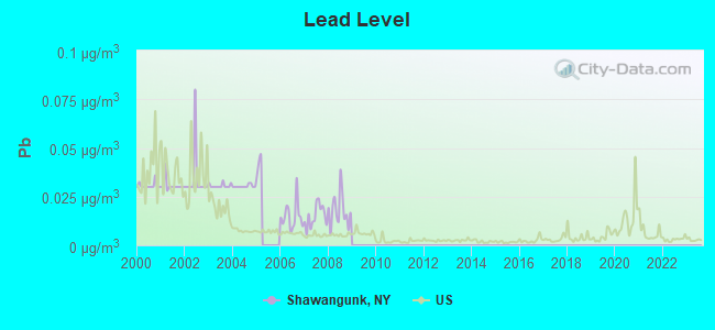
Lead (Pb) [µg/m3] level in 2008 was 0.0179. This is significantly worse than average. Closest monitor was 12.4 miles away from the city center.
| City: | 0.0179 |
| U.S.: | 0.0093 |
Tornado activity:
Shawangunk-area historical tornado activity is above New York state average. It is 36% smaller than the overall U.S. average.
On 7/14/1988, a category F3 (max. wind speeds 158-206 mph) tornado 23.3 miles away from the Shawangunk town center injured one person and caused between $500,000 and $5,000,000 in damages.
On 7/10/1989, a category F4 (max. wind speeds 207-260 mph) tornado 53.8 miles away from the town center injured 20 people and caused between $5,000,000 and $50,000,000 in damages.
Earthquake activity:
Shawangunk-area historical earthquake activity is significantly above New York state average. It is 67% smaller than the overall U.S. average.On 10/7/1983 at 10:18:46, a magnitude 5.3 (5.1 MB, 5.3 LG, 5.1 ML, Class: Moderate, Intensity: VI - VII) earthquake occurred 161.7 miles away from the city center
On 4/20/2002 at 10:50:47, a magnitude 5.3 (5.3 ML, Depth: 3.0 mi) earthquake occurred 202.1 miles away from the city center
On 4/20/2002 at 10:50:47, a magnitude 5.2 (5.2 MB, 4.2 MS, 5.2 MW, 5.0 MW) earthquake occurred 200.3 miles away from the city center
On 8/23/2011 at 17:51:04, a magnitude 5.8 (5.8 MW, Depth: 3.7 mi) earthquake occurred 323.2 miles away from Shawangunk center
On 1/16/1994 at 01:49:16, a magnitude 4.6 (4.6 MB, 4.6 LG, Depth: 3.1 mi, Class: Light, Intensity: IV - V) earthquake occurred 129.6 miles away from the city center
On 1/19/1982 at 00:14:42, a magnitude 4.7 (4.5 MB, 4.7 MD, 4.5 LG) earthquake occurred 187.0 miles away from Shawangunk center
Magnitude types: regional Lg-wave magnitude (LG), body-wave magnitude (MB), duration magnitude (MD), local magnitude (ML), surface-wave magnitude (MS), moment magnitude (MW)
Natural disasters:
The number of natural disasters in Ulster County (32) is a lot greater than the US average (15).Major Disasters (Presidential) Declared: 23
Emergencies Declared: 8
Causes of natural disasters: Floods: 12, Storms: 12, Hurricanes: 6, Snowstorms: 3, Blizzards: 2, Tropical Storms: 2, Power Outage: 1, Tornado: 1, Tropical Depression: 1, Water Shortage: 1, Wind: 1, Winter Storm: 1, Other: 3 (Note: some incidents may be assigned to more than one category).
Hospitals and medical centers near Shawangunk:
- MONTGOMERY NURSING AND REHABILITATION CENTER (Nursing Home, about 5 miles away; MONTGOMERY, NY)
- UCPA OF ULSTER COUNTY (Hospital, about 9 miles away; NEW PALTZ, NY)
- ELANT AT NEWBURGH INC (Nursing Home, about 10 miles away; NEWBURGH, NY)
- THE MOUNTAIN VIEW NURSING AND REHAB CENTRE (Nursing Home, about 11 miles away; NEW PALTZ, NY)
- WILLCARE HUDSON VALLEY CHHA (Home Health Center, about 11 miles away; NEWBURGH, NY)
- CAMPBELL HALL REHAB CENTER (Nursing Home, about 12 miles away; CAMPBELL HALL, NY)
- HOSPICE OF ORANGE AND SULLIVAN COUNTIES INC (Hospital, about 13 miles away; NEWBURGH, NY)
Colleges/universities with over 2000 students nearest to Shawangunk:
- State University of New York at New Paltz (about 12 miles; New Paltz, NY; Full-time enrollment: 7,319)
- Mount Saint Mary College (about 14 miles; Newburgh, NY; FT enrollment: 2,166)
- Orange County Community College (about 16 miles; Middletown, NY; FT enrollment: 4,742)
- Marist College (about 18 miles; Poughkeepsie, NY; FT enrollment: 5,536)
- Ulster County Community College (about 18 miles; Stone Ridge, NY; FT enrollment: 2,207)
- Culinary Institute of America (about 18 miles; Hyde Park, NY; FT enrollment: 3,869)
- Vassar College (about 19 miles; Poughkeepsie, NY; FT enrollment: 2,469)
Points of interest:
Notable locations in Shawangunk: Walker Valley Golf Course (A), Baldwin Vineyards (B), Brimstone Hill Vineyards (C), Magnanini Winery (D), Orchard Hill Nursery (E), Sir Waltree Plantation (F), Quannacut YMCA Camp (G), Watchtower Farms (H), Dolan Orchards (I), Wallkill State Prison (J), Wallkill Public Library (K), Shawangunk Town Hall (L), Walker Valley Fire Company House (M). Display/hide their locations on the map
Churches in Shawangunk include: Crawford Church (A), Shawangunk Reformed Church (B), Mid Hudson Christian Church (C), Wallkill Reformed Church (D), Berean Baptist Church (E), New Prospect Church (F), Our Lady of the Valley Church (G). Display/hide their locations on the map
Cemeteries: Bruynswick Cemetery (1), Mulford Cemetery (2). Display/hide their locations on the map
Lakes, reservoirs, and swamps: Pinebush Lake (A), Murrays Pond (B), Cedar Swamp (C). Display/hide their locations on the map
Streams, rivers, and creeks: Pakanasink Creek (A), Beaver Brook (B), Tomy Kill (C), Verkeerder Kill (D). Display/hide their locations on the map
Parks in Shawangunk include: Garrison Park (1), Shawangunk Grasslands National Wildlife Refuge (2). Display/hide their locations on the map
| This town: | 2.8 people |
| New York: | 2.6 people |
| This town: | 74.5% |
| Whole state: | 63.5% |
| This town: | 8.0% |
| Whole state: | 6.8% |
Likely homosexual households (counted as self-reported same-sex unmarried-partner households)
- Lesbian couples: 0.3% of all households
- Gay men: 0.3% of all households
| This town: | 13.4% |
| Whole state: | 14.6% |
| This town: | 6.0% |
| Whole state: | 7.4% |
People in group quarters in Shawangunk in 2010:
- 1,288 people in other noninstitutional facilities
- 1,110 people in state prisons
- 1,106 people in workers' group living quarters and job corps centers
- 21 people in group homes intended for adults
People in group quarters in Shawangunk in 2000:
- 1,301 people in other nonhousehold living situations
- 1,159 people in state prisons
- 14 people in homes for the mentally retarded
- 6 people in other noninstitutional group quarters
- 2 people in religious group quarters
For population 15 years and over in Shawangunk:
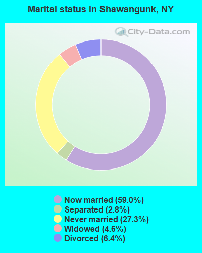
- Never married: 27.3%
- Now married: 59.0%
- Separated: 2.8%
- Widowed: 4.6%
- Divorced: 6.4%
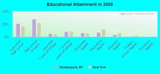
For population 25 years and over in Shawangunk:
- High school or higher: 73.8%
- Bachelor's degree or higher: 14.6%
- Graduate or professional degree: 5.7%
- Unemployed: 18.5%
- Mean travel time to work (commute): 30.7 minutes

| Here: | 12.1 |
| New York average: | 14.2 |
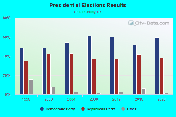
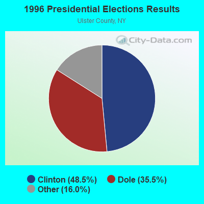
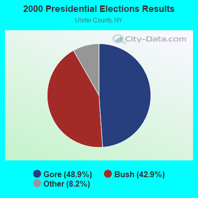
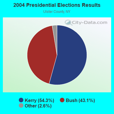
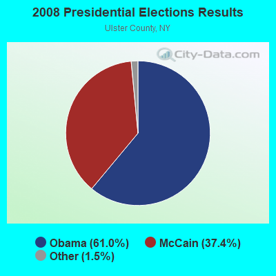

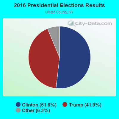
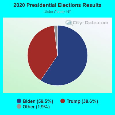
Graphs represent county-level data. Detailed 2008 Election Results
Religion statistics for Shawangunk, NY (based on Ulster County data)
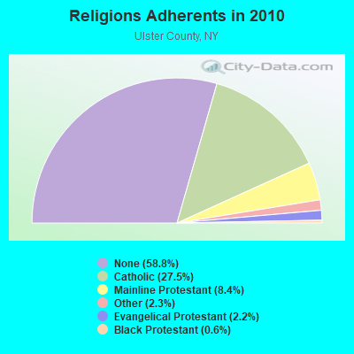
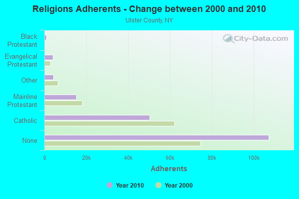
| Religion | Adherents | Congregations |
|---|---|---|
| Catholic | 50,256 | 27 |
| Mainline Protestant | 15,311 | 78 |
| Other | 4,262 | 30 |
| Evangelical Protestant | 4,104 | 42 |
| Black Protestant | 1,064 | 7 |
| Orthodox | 150 | 1 |
| None | 107,346 | - |
Food Environment Statistics:
| Here: | 2.48 / 10,000 pop. |
| State: | 4.13 / 10,000 pop. |
| Ulster County: | 0.11 / 10,000 pop. |
| New York: | 0.06 / 10,000 pop. |
| This county: | 1.27 / 10,000 pop. |
| New York: | 0.92 / 10,000 pop. |
| Ulster County: | 3.91 / 10,000 pop. |
| New York: | 1.68 / 10,000 pop. |
| Ulster County: | 12.61 / 10,000 pop. |
| New York: | 8.82 / 10,000 pop. |
| Here: | 8.1% |
| State: | 8.2% |
| Ulster County: | 26.7% |
| State: | 23.8% |
| Ulster County: | 18.9% |
| New York: | 15.6% |
Strongest AM radio stations in Shawangunk:
- WGNY (1220 AM; 10 kW; NEWBURGH, NY; Owner: SUNRISE BROADCASTING LLC)
- WELV (1370 AM; daytime; 5 kW; ELLENVILLE, NY; Owner: CLEAR CHANNEL BROADCASTING LICENSES, INC.)
- WABC (770 AM; 50 kW; NEW YORK, NY; Owner: WABC-AM RADIO, INC.)
- WMCA (570 AM; 50 kW; NEW YORK, NY; Owner: SALEM MEDIA OF NEW YORK, LLC)
- WFAN (660 AM; 50 kW; NEW YORK, NY; Owner: INFINITY BROADCASTING OPERATIONS, INC.)
- WOR (710 AM; 50 kW; NEW YORK, NY; Owner: BUCKLEY BROADCASTING CORPORATION)
- WCBS (880 AM; 50 kW; NEW YORK, NY; Owner: INFINITY BROADCASTING OPERATIONS, INC.)
- WINS (1010 AM; 50 kW; NEW YORK, NY; Owner: INFINITY BROADCASTING OPERATIONS, INC.)
- WEPN (1050 AM; 50 kW; NEW YORK, NY; Owner: NEW YORK AM RADIO, LLC)
- WSNR (620 AM; 20 kW; JERSEY CITY, NJ)
- WBBR (1130 AM; 50 kW; NEW YORK, NY; Owner: BLOOMBERG COMMUNICATIONS INC.)
- WADO (1280 AM; 50 kW; NEW YORK, NY; Owner: WADO-AM LICENSE CORP.)
- WVNJ (1160 AM; 20 kW; OAKLAND, NJ; Owner: UNIVERSAL B/CASTING OF NEW YORK,INC.)
Strongest FM radio stations in Shawangunk:
- WFKP (99.3 FM; ELLENVILLE, NY; Owner: CLEAR CHANNEL BROADCASTING LICENSES, INC.)
- WPDH (101.5 FM; POUGHKEEPSIE, NY; Owner: CUMULUS LICENSING CORP.)
- WFNP (88.7 FM; ROSENDALE, NY; Owner: STATE UNIVERSITY OF NEW YORK)
- WRHV (88.7 FM; POUGHKEEPSIE, NY; Owner: WMHT EDUCATIONAL TELECOMMUNICATIONS)
- WBWZ (93.3 FM; NEW PALTZ, NY; Owner: CLEVELAND RADIO LICENSES, LLC)
- WRWD-FM (107.3 FM; HIGHLAND, NY; Owner: CLEVELAND RADIO LICENSES, LLC)
- WCZX (97.7 FM; HYDE PARK, NY; Owner: CUMULUS LICENSING CORP.)
- WRRB (96.9 FM; ARLINGTON, NY; Owner: CUMULUS LICENSING CORP.)
- WSPK (104.7 FM; POUGHKEEPSIE, NY; Owner: 6 JOHNSON ROAD LICENSES, INC.)
- WLJP (89.3 FM; MONROE, NY; Owner: SOUND OF LIFE, INC.)
- W292CM (106.3 FM; POUGHKEEPSIE, NY; Owner: JOHN KATONAH)
- WZAD (97.3 FM; WURTSBORO, NY; Owner: CUMULUS LICENSING CORP.)
- WRNQ (92.1 FM; POUGHKEEPSIE, NY; Owner: CLEAR CHANNEL BROADCASTING LICENSES, INC.)
- WOSR (91.7 FM; MIDDLETOWN, NY; Owner: WAMC)
- WAMK (90.9 FM; KINGSTON, NY; Owner: W A M C)
- WFGB (89.7 FM; KINGSTON, NY; Owner: SOUND OF LIFE, INC.)
- WGNY-FM (103.1 FM; NEWBURGH, NY; Owner: SUNRISE BROADCASTING LLC)
- WXHD (90.1 FM; MOUNT HOPE, NY; Owner: AURICLE COMMUNICATIONS)
- WRPJ (88.9 FM; PORT JERVIS, NY; Owner: SOUND OF LIFE, INC.)
- WRRV (92.7 FM; MIDDLETOWN, NY; Owner: CUMULUS LICENSING CORP.)
TV broadcast stations around Shawangunk:
- WTBY (Channel 54; POUGHKEEPSIE, NY; Owner: TRINITY BROADCASTING OF NEW YORK, INC.)
- WFME-TV (Channel 66; WEST MILFORD, NJ; Owner: FAMILY STATIONS, INC.)
- WRNN-TV (Channel 62; KINGSTON, NY; Owner: WRNN-TV ASSOCIATES LIMITED PARTNERSHIP)
- W42AE (Channel 42; POUGHKEEPSIE, NY; Owner: DUTCHESS COMMUNITY COLLEGE)
- National Bridge Inventory (NBI) Statistics
- 22Number of bridges
- 177ft / 53.6mTotal length
- $51,025,000Total costs
- 29,830Total average daily traffic
- 2,051Total average daily truck traffic
- 39,713Total future (year 2034) average daily traffic
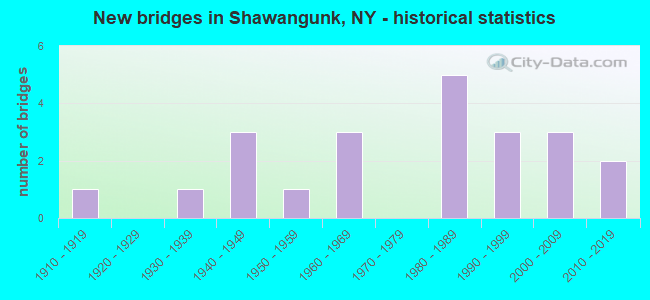
- New bridges - historical statistics
- 11910-1919
- 11930-1939
- 31940-1949
- 11950-1959
- 31960-1969
- 51980-1989
- 31990-1999
- 32000-2009
- 22010-2019
- 75.0%Fuel oil, kerosene, etc.
- 6.8%Wood
- 6.2%Utility gas
- 6.0%Electricity
- 3.9%Bottled, tank, or LP gas
- 1.3%Coal or coke
- 0.7%Other fuel
- 57.6%Fuel oil, kerosene, etc.
- 19.6%Electricity
- 11.6%Bottled, tank, or LP gas
- 10.3%Utility gas
- 1.0%Wood
Shawangunk compared to New York state average:
- Hispanic race population percentage below state average.
- Foreign-born population percentage significantly below state average.
- Renting percentage significantly below state average.
- Length of stay since moving in significantly above state average.
- Number of rooms per house significantly below state average.
- House age significantly below state average.
- Institutionalized population percentage significantly above state average.
- Percentage of population with a bachelor's degree or higher below state average.
Shawangunk on our top lists:
- #4 on the list of "Top 101 cities with the largest percentage of people in other nonhousehold living situations (population 1,000+)"
- #9 on the list of "Top 101 cities with largest percentage of males in occupations: cashiers (population 5,000+)"
- #14 on the list of "Top 101 cities with the lowest number of police officers per 1000 residents (population 5,000+)"
- #17 on the list of "Top 101 cities with largest percentage of females in industries: other transportation, and support activities, and couriers (population 5,000+)"
- #18 on the list of "Top 101 cities with largest percentage of females in industries: sporting goods, camera, and hobby and toy stores (population 5,000+)"
- #23 on the list of "Top 101 cities with largest percentage of males in occupations: other construction workers and helpers (population 5,000+)"
- #25 on the list of "Top 101 cities with largest percentage of females in occupations: bus drivers (population 5,000+)"
- #26 on the list of "Top 101 cities with largest percentage of males in industries: alcoholic beverages merchant wholesalers (population 5,000+)"
- #39 on the list of "Top 101 cities with largest percentage of males in industries: religious, grantmaking, civic, professional, and similar organizations (population 5,000+)"
- #40 on the list of "Top 101 cities with largest percentage of males in occupations: child care workers (population 5,000+)"
- #42 on the list of "Top 101 cities with largest percentage of males in industries: social assistance (population 5,000+)"
- #43 on the list of "Top 101 cities with largest percentage of females in industries: vending machine operators (population 5,000+)"
- #45 on the list of "Top 101 cities with largest percentage of females in occupations: other teachers and instructors, education, training, and library occupations (population 5,000+)"
- #45 on the list of "Top 101 cities with largest percentage of males in industries: machinery, equipment, and supplies merchant wholesalers (population 5,000+)"
- #48 on the list of "Top 101 cities with largest percentage of males in occupations: plant and system operators (population 5,000+)"
- #58 on the list of "Top 101 cities with largest percentage of males in industries: broadcasting, internet publishing, and telecommunications services (population 5,000+)"
- #58 on the list of "Top 101 cities with largest percentage of females in industries: broadcasting, internet publishing, and telecommunications services (population 5,000+)"
- #58 on the list of "Top 101 cities with largest percentage of males in industries: wholesale electronic markets and agents and brokers (population 5,000+)"
- #58 on the list of "Top 101 cities with largest percentage of females in industries: wholesale electronic markets and agents and brokers (population 5,000+)"
- #59 on the list of "Top 101 cities with largest percentage of females in industries: repair and maintenance (population 5,000+)"
- #7 on the list of "Top 101 counties with the highest surface withdrawal of fresh water for public supply"
- #9 on the list of "Top 101 counties with the highest total withdrawal of fresh water for public supply"
- #13 on the list of "Top 101 counties with the lowest percentage of residents relocating from foreign countries between 2010 and 2011"
- #18 on the list of "Top 101 counties with the lowest number of births per 1000 residents 2007-2013"
- #44 on the list of "Top 101 counties with the lowest Sulfur Oxides Annual air pollution readings in 2012 (µg/m3)"