Solon, Iowa
Submit your own pictures of this city and show them to the world
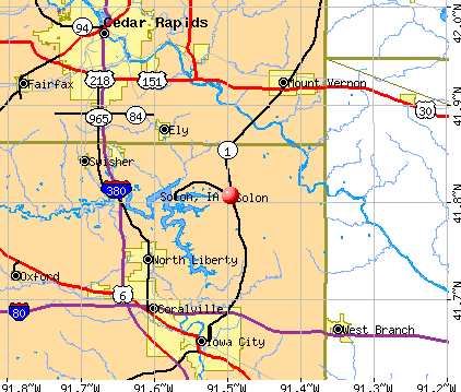
- OSM Map
- General Map
- Google Map
- MSN Map
Population change since 2000: +167.6%
| Males: 1,335 | |
| Females: 1,815 |
| Median resident age: | 37.3 years |
| Iowa median age: | 38.9 years |
Zip codes: 52333.
| Solon: | $116,768 |
| IA: | $69,588 |
Estimated per capita income in 2022: $39,624 (it was $18,029 in 2000)
Solon city income, earnings, and wages data
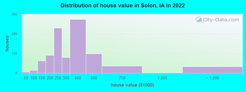
Estimated median house or condo value in 2022: $290,310 (it was $110,300 in 2000)
| Solon: | $290,310 |
| IA: | $194,600 |
Mean prices in 2022: all housing units: $447,728; detached houses: $500,089; townhouses or other attached units: $274,003; in 5-or-more-unit structures: $214,525
Median gross rent in 2022: $1,102.
(1.9% for White Non-Hispanic residents, 42.9% for Black residents)
Detailed information about poverty and poor residents in Solon, IA


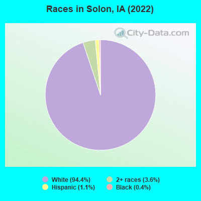
- 2,90794.4%White alone
- 1103.6%Two or more races
- 331.1%Hispanic
- 130.4%Black alone
Races in Solon detailed stats: ancestries, foreign born residents, place of birth
According to our research of Iowa and other state lists, there was 1 registered sex offender living in Solon, Iowa as of May 14, 2024.
The ratio of all residents to sex offenders in Solon is 2,420 to 1.
The ratio of registered sex offenders to all residents in this city is much lower than the state average.
 Recent articles from our blog. Our writers, many of them Ph.D. graduates or candidates, create easy-to-read articles on a wide variety of topics.

 | Relocating to Iowa City next year (3 replies) |
| Country living for Grad Student (4 replies) |
| Great High School in Iowa City (5 replies) |
| Farm/Country-style house rental near Iowa City (7 replies) |
| Ely, Solon, Swisher or North Liberty? (1 reply) |
| Affordable housing for first time homebuyer? (11 replies) |
Latest news from Solon, IA collected exclusively by city-data.com from local newspapers, TV, and radio stations
Ancestries: German (50.6%), Irish (9.7%), English (7.8%), Czech (6.5%), Norwegian (5.3%), American (4.2%).
Current Local Time: CST time zone
Incorporated on 04/28/1877
Elevation: 790 feet
Land area: 1.33 square miles.
Population density: 2,374 people per square mile (low).
9 residents are foreign born
| This city: | 0.3% |
| Iowa: | 5.6% |
Median real estate property taxes paid for housing units with mortgages in 2022: $4,159 (1.4%)
Median real estate property taxes paid for housing units with no mortgage in 2022: $4,074 (1.5%)
Nearest city with pop. 50,000+: Iowa City, IA  (10.5 miles , pop. 62,220).
Nearest city with pop. 200,000+: Madison, WI (138.5 miles , pop. 208,054).
Nearest city with pop. 1,000,000+: Chicago, IL (196.7 miles , pop. 2,896,016).
Nearest cities:
), ), Latitude: 41.81 N, Longitude: 91.50 W
Area code: 319
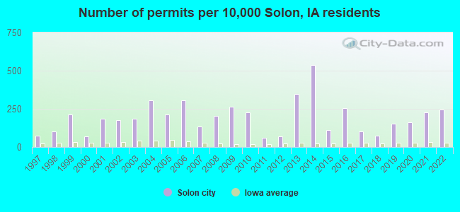
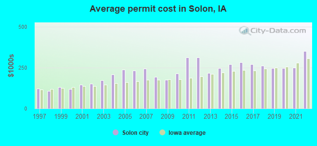
Single-family new house construction building permits:
- 2022: 29 buildings, average cost: $352,900
- 2021: 27 buildings, average cost: $251,400
- 2020: 19 buildings, average cost: $246,600
- 2019: 18 buildings, average cost: $246,600
- 2018: 9 buildings, average cost: $263,200
- 2017: 12 buildings, average cost: $270,900
- 2016: 30 buildings, average cost: $281,700
- 2015: 13 buildings, average cost: $271,800
- 2014: 63 buildings, average cost: $247,300
- 2013: 41 buildings, average cost: $219,000
- 2012: 8 buildings, average cost: $312,100
- 2011: 7 buildings, average cost: $312,100
- 2010: 27 buildings, average cost: $213,800
- 2009: 31 buildings, average cost: $177,400
- 2008: 24 buildings, average cost: $193,300
- 2007: 16 buildings, average cost: $245,100
- 2006: 36 buildings, average cost: $232,700
- 2005: 25 buildings, average cost: $238,700
- 2004: 36 buildings, average cost: $208,600
- 2003: 22 buildings, average cost: $171,900
- 2002: 21 buildings, average cost: $152,100
- 2001: 22 buildings, average cost: $145,000
- 2000: 8 buildings, average cost: $119,300
- 1999: 25 buildings, average cost: $131,500
- 1998: 12 buildings, average cost: $107,900
- 1997: 9 buildings, average cost: $122,200
| Here: | 2.0% |
| Iowa: | 2.7% |
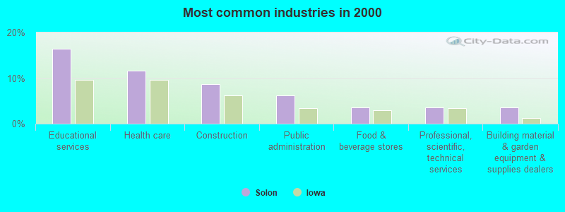
- Educational services (16.4%)
- Health care (11.6%)
- Construction (8.6%)
- Public administration (6.2%)
- Food & beverage stores (3.6%)
- Professional, scientific, technical services (3.6%)
- Building material & garden equipment & supplies dealers (3.6%)
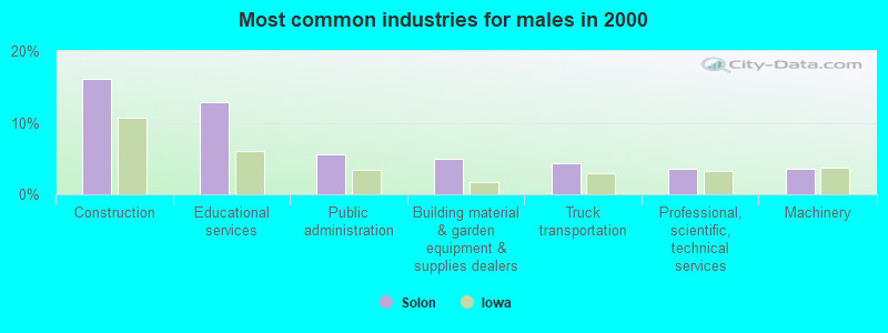
- Construction (16.1%)
- Educational services (12.8%)
- Public administration (5.6%)
- Building material & garden equipment & supplies dealers (4.9%)
- Truck transportation (4.3%)
- Professional, scientific, technical services (3.6%)
- Machinery (3.6%)
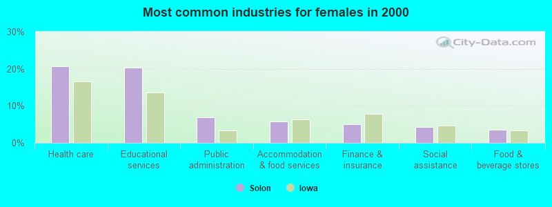
- Health care (20.7%)
- Educational services (20.3%)
- Public administration (6.9%)
- Accommodation & food services (5.8%)
- Finance & insurance (5.1%)
- Social assistance (4.3%)
- Food & beverage stores (3.6%)
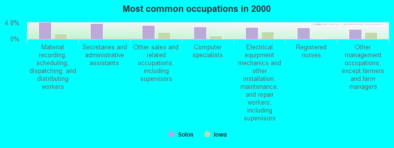
- Material recording, scheduling, dispatching, and distributing workers (4.8%)
- Secretaries and administrative assistants (4.7%)
- Other sales and related occupations, including supervisors (4.1%)
- Computer specialists (3.6%)
- Electrical equipment mechanics and other installation, maintenance, and repair workers, including supervisors (3.4%)
- Registered nurses (3.3%)
- Other management occupations, except farmers and farm managers (2.9%)
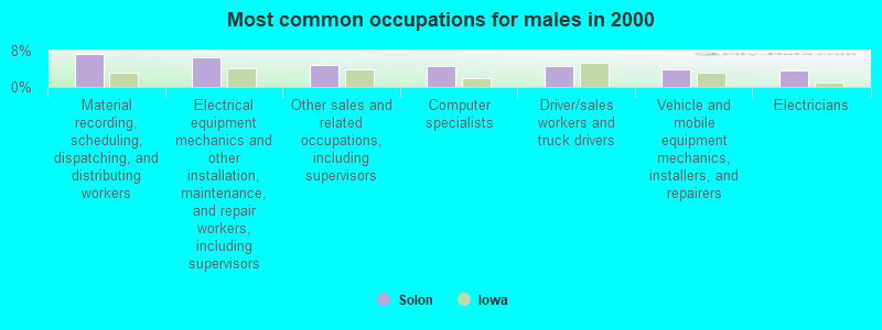
- Material recording, scheduling, dispatching, and distributing workers (7.2%)
- Electrical equipment mechanics and other installation, maintenance, and repair workers, including supervisors (6.6%)
- Other sales and related occupations, including supervisors (4.9%)
- Computer specialists (4.6%)
- Driver/sales workers and truck drivers (4.6%)
- Vehicle and mobile equipment mechanics, installers, and repairers (3.9%)
- Electricians (3.6%)

- Secretaries and administrative assistants (9.8%)
- Registered nurses (6.9%)
- Child care workers (5.1%)
- Other office and administrative support workers, including supervisors (4.7%)
- Accountants and auditors (4.0%)
- Counselors, social workers, and other community and social service specialists (4.0%)
- Information and record clerks, except customer service representatives (4.0%)
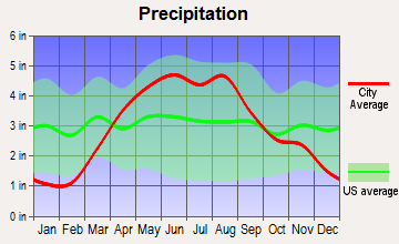
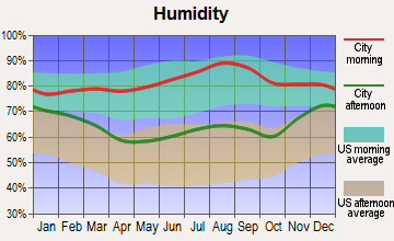
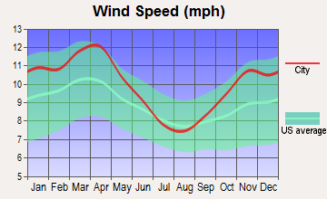
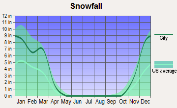
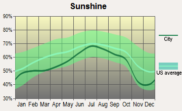
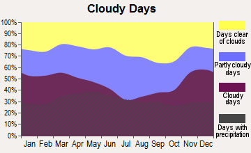
Average climate in Solon, Iowa
Based on data reported by over 4,000 weather stations

|
|


(lower is better)
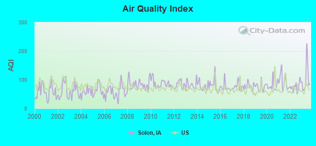
Air Quality Index (AQI) level in 2023 was 105. This is significantly worse than average.
| City: | 105 |
| U.S.: | 73 |
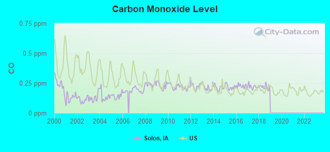
Carbon Monoxide (CO) [ppm] level in 2018 was 0.217. This is about average. Closest monitor was 11.7 miles away from the city center.
| City: | 0.217 |
| U.S.: | 0.251 |
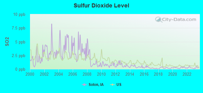
Sulfur Dioxide (SO2) [ppb] level in 2023 was 0.268. This is significantly better than average. Closest monitor was 10.4 miles away from the city center.
| City: | 0.268 |
| U.S.: | 1.515 |
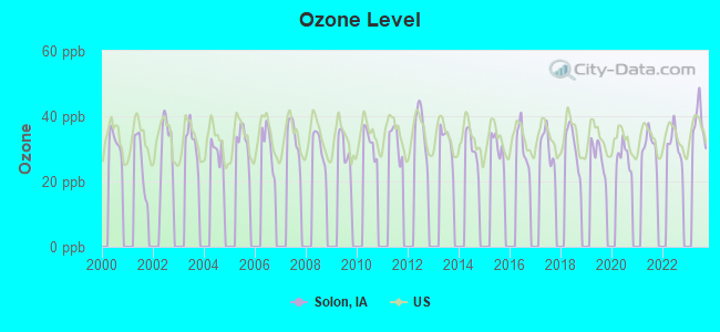
Ozone [ppb] level in 2023 was 38.0. This is about average. Closest monitor was 8.9 miles away from the city center.
| City: | 38.0 |
| U.S.: | 33.3 |
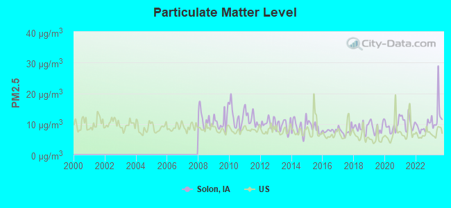
Particulate Matter (PM2.5) [µg/m3] level in 2023 was 12.9. This is significantly worse than average. Closest monitor was 10.3 miles away from the city center.
| City: | 12.9 |
| U.S.: | 8.1 |
Tornado activity:
Solon-area historical tornado activity is near Iowa state average. It is 98% greater than the overall U.S. average.
On 6/7/1984, a category F4 (max. wind speeds 207-260 mph) tornado 24.1 miles away from the Solon city center killed 3 people and injured 64 people and caused between $5,000,000 and $50,000,000 in damages.
On 4/30/1954, a category F4 tornado 24.1 miles away from the city center .
Earthquake activity:
Solon-area historical earthquake activity is significantly above Iowa state average. It is 139% greater than the overall U.S. average.On 4/18/2008 at 09:36:59, a magnitude 5.4 (5.1 MB, 4.8 MS, 5.4 MW, 5.2 MW, Class: Moderate, Intensity: VI - VII) earthquake occurred 300.4 miles away from Solon center
On 6/10/1987 at 23:48:54, a magnitude 5.1 (4.9 MB, 4.4 MS, 4.6 MS, 5.1 LG) earthquake occurred 280.9 miles away from the city center
On 4/18/2008 at 09:36:59, a magnitude 5.2 (5.2 MW, Depth: 8.9 mi) earthquake occurred 300.4 miles away from Solon center
On 6/28/2004 at 06:10:52, a magnitude 4.2 (4.2 MW, Depth: 6.2 mi, Class: Light, Intensity: IV - V) earthquake occurred 136.3 miles away from the city center
On 6/18/2002 at 17:37:15, a magnitude 5.0 (4.3 MB, 4.6 MW, 5.0 LG) earthquake occurred 329.6 miles away from the city center
On 4/18/2008 at 15:14:16, a magnitude 4.8 (4.5 MB, 4.8 MW, 4.6 MW) earthquake occurred 300.4 miles away from the city center
Magnitude types: regional Lg-wave magnitude (LG), body-wave magnitude (MB), surface-wave magnitude (MS), moment magnitude (MW)
Natural disasters:
The number of natural disasters in Johnson County (23) is greater than the US average (15).Major Disasters (Presidential) Declared: 21
Emergencies Declared: 1
Causes of natural disasters: Floods: 17, Storms: 15, Tornadoes: 6, Winds: 2, Winter Storms: 2, Heavy Rain: 1, Hurricane: 1, Other: 1 (Note: some incidents may be assigned to more than one category).
Hospitals and medical centers in Solon:
Other hospitals and medical centers near Solon:
- UNIVERSITY OF IOWA HOSPITAL AND CLINICS - NORTH LIBERTY (Dialysis Facility, about 8 miles away; NORTH LIBERTY, IA)
- LANTERN PARK NURSING AND REHAB C (Nursing Home, about 9 miles away; CORALVILLE, IA)
- WINDMILL MANOR (Nursing Home, about 9 miles away; CORALVILLE, IA)
- REM IOWA-CORALVILLE (Hospital, about 10 miles away; CORALVILLE, IA)
- IOWA CITY REHAB AND HEALTH CARE (Nursing Home, about 10 miles away; IOWA CITY, IA)
- MERCY HOSPITAL Acute Care Hospitals (about 11 miles away; IOWA CITY, IA)
- UNIVERSITY OF IOWA HOSPITAL AND CLINICS DIALYSIS (Dialysis Facility, about 11 miles away; IOWA CITY, IA)
Colleges/universities with over 2000 students nearest to Solon:
- University of Iowa (about 11 miles; Iowa City, IA; Full-time enrollment: 24,735)
- Kirkwood Community College (about 11 miles; Cedar Rapids, IA; FT enrollment: 11,503)
- Saint Ambrose University (about 51 miles; Davenport, IA; FT enrollment: 3,053)
- Eastern Iowa Community College District (about 52 miles; Davenport, IA; FT enrollment: 5,507)
- Kaplan University-Davenport Campus (about 52 miles; Davenport, IA; FT enrollment: 60,376)
- Augustana College (about 54 miles; Rock Island, IL; FT enrollment: 2,555)
- Black Hawk College (about 59 miles; Moline, IL; FT enrollment: 5,086)
Public high school in Solon:
- SOLON HIGH SCHOOL (Students: 350, Location: 600 W. 5TH STREET, Grades: 9-12)
Public elementary/middle schools in Solon:
- LAKEVIEW ELEMENTARY (Students: 507, Location: 111 N CHABAL ST, Grades: PK-4)
- SOLON MIDDLE SCHOOL (Students: 361, Location: 313 SOUTH IOWA STREET, Grades: 5-8)
User-submitted facts and corrections:
- solon, iowa has changed the jr. high and the high school to just the jr. high school, and has built a new high school.
Points of interest:
Notable locations in Solon: Solon City Hall (A), Solon Public Library (B), Solon Volunteer Fire Department (C). Display/hide their locations on the map
Church in Solon: Solon United Methodist Church (A). Display/hide its location on the map
Cemetery: Saint Marys Cemetery (1). Display/hide its location on the map
Birthplace of: Hans Stolfus - Beach volleyball player.
Drinking water stations with addresses in Solon and their reported violations in the past:
COTTAGE RESERVE CORPORATION (Address: 3784 COTTAGE RESERVE RD NE , Population served: 198, Groundwater):Past monitoring violations:HIDDEN ACRES SUBDIVISION (Address: 2671 HIDDEN VALLEY TR NE , Population served: 90, Groundwater):
- Monitoring and Reporting (DBP) - Between JUL-2009 and AUG-2011, Contaminant: TTHM. Follow-up actions: St Formal NOV issued (OCT-19-2011), St Public Notif requested (OCT-19-2011), St AO (w/o penalty) issued (NOV-29-2011), St Compliance achieved (AUG-20-2012)
- Monitoring and Reporting (DBP) - Between JUL-2009 and AUG-2011, Contaminant: Total Haloacetic Acids (HAA5). Follow-up actions: St Public Notif requested (OCT-19-2011), St Formal NOV issued (OCT-19-2011), St BCA signed (NOV-29-2011), St Compliance achieved (AUG-20-2012)
- Follow-up Or Routine LCR Tap M/R - In JUN-01-2003, Contaminant: Lead and Copper Rule. Follow-up actions: St Public Notif requested (DEC-07-2005), St Formal NOV issued (DEC-07-2005), St BCA signed (DEC-07-2005), St Compliance achieved (SEP-29-2006)
Past health violations:SUTLIFF INC (Address: 1940 ST BRIDGES RD , Population served: 50, Groundwater):Past monitoring violations:
- MCL, Monthly (TCR) - In JUN-2010, Contaminant: Coliform. Follow-up actions: St BCA signed (3 times from AUG-26-2009 to NOV-23-2009), St Formal NOV issued (JUN-15-2010), St Public Notif requested (JUN-15-2010), St Public Notif received (JUN-24-2010), St Compliance achieved (JAN-10-2011)
- MCL, Monthly (TCR) - In AUG-2009, Contaminant: Coliform. Follow-up actions: St Violation/Reminder Notice (AUG-13-2009), St Formal NOV issued (AUG-17-2009), St Public Notif requested (AUG-17-2009), St BCA signed (AUG-26-2009), St Public Notif received (SEP-04-2009), St Compliance achieved (SEP-23-2009), St BCA signed (2 times from OCT-06-2009 to NOV-23-2009)
- MCL, Monthly (TCR) - In AUG-2009, Contaminant: Coliform. Follow-up actions: St Public Notif requested (AUG-17-2009), St Formal NOV issued (AUG-17-2009), St Violation/Reminder Notice (AUG-17-2009), St Public Notif received (SEP-04-2009), St Compliance achieved (FEB-02-2010)
- MCL, Monthly (TCR) - In JUL-2009, Contaminant: Coliform. Follow-up actions: St Public Notif requested (JUL-28-2009), St Formal NOV issued (JUL-28-2009), St Public Notif received (AUG-12-2009), St BCA signed (AUG-26-2009), St Compliance achieved (SEP-23-2009), St BCA signed (2 times from OCT-06-2009 to NOV-23-2009)
- MCL, Monthly (TCR) - In JUN-2009, Contaminant: Coliform. Follow-up actions: St Violation/Reminder Notice (JUN-25-2009), St Public Notif requested (JUN-30-2009), St Formal NOV issued (JUN-30-2009), St Public Notif received (JUL-20-2009), St BCA signed (AUG-26-2009), St Compliance achieved (SEP-23-2009), St BCA signed (2 times from OCT-06-2009 to NOV-23-2009)
- MCL, Monthly (TCR) - In SEP-2008, Contaminant: Coliform. Follow-up actions: St Violation/Reminder Notice (SEP-29-2008), St Formal NOV issued (OCT-06-2008), St Public Notif requested (OCT-06-2008), St Public Notif received (OCT-15-2008), St Compliance achieved (MAR-19-2009)
- 9 other older health violations
- Monitoring, Repeat Major (TCR) - Between OCT-2007 and NOV-2007, Contaminant: Coliform (TCR). Follow-up actions: St Compliance achieved (NOV-14-2007), St Formal NOV issued (NOV-26-2007), St Public Notif requested (NOV-26-2007), St Public Notif received (DEC-06-2007)
Past health violations:GALLERY ACRES WEST (Address: 2671 HIDDEN VALLEY TRAIL NE , Population served: 43, Groundwater):Past monitoring violations:
- MCL, Monthly (TCR) - Between JAN-2013 and MAR-2013, Contaminant: Coliform. Follow-up actions: St Formal NOV issued (MAR-22-2013), St Public Notif requested (MAR-22-2013), St Compliance achieved (APR-13-2013), St Public Notif received (APR-22-2013)
- MCL, Acute (TCR) - Between APR-2008 and JUN-2008, Contaminant: Coliform. Follow-up actions: St Public Notif requested (JUN-23-2008), St Formal NOV issued (JUN-23-2008), St Compliance achieved (DEC-16-2008)
- MCL, Monthly (TCR) - Between APR-2008 and JUN-2008, Contaminant: Coliform. Follow-up actions: St Violation/Reminder Notice (JUN-12-2008), St Compliance achieved (DEC-16-2008)
- MCL, Monthly (TCR) - Between APR-2007 and JUN-2007, Contaminant: Coliform. Follow-up actions: St Violation/Reminder Notice (JUL-02-2007), St Public Notif requested (JUL-23-2007), St Formal NOV issued (JUL-23-2007), St Compliance achieved (MAR-17-2008)
- MCL, Monthly (TCR) - Between OCT-2006 and DEC-2006, Contaminant: Coliform. Follow-up actions: St Public Notif requested (OCT-23-2006), St Formal NOV issued (OCT-23-2006), St Compliance achieved (JUN-26-2007)
- MCL, Monthly (TCR) - Between JUL-2006 and SEP-2006, Contaminant: Coliform. Follow-up actions: St Violation/Reminder Notice (SEP-29-2006), St Public Notif requested (OCT-05-2006), St Formal NOV issued (OCT-05-2006), St Compliance achieved (JUN-26-2007)
- MCL, Monthly (TCR) - In FEB-2005, Contaminant: Coliform. Follow-up actions: St Violation/Reminder Notice (FEB-14-2005), St Formal NOV issued (FEB-21-2005), St Public Notif requested (FEB-21-2005), St Public Notif received (MAR-02-2005), St Compliance achieved (JUL-08-2005)
- One routine major monitoring violation
- One regular monitoring violation
Past health violations:LAKE MACBRIDE STATE PARK-EAST (Address: 3525 HWY 382 NE , Population served: 27, Groundwater):Past monitoring violations:
- MCL, Average - Between JAN-2014 and MAR-2014, Contaminant: Arsenic. Follow-up actions: St AO (w/o penalty) issued (3 times from FEB-06-2006 to FEB-19-2013), St Public Notif requested (JAN-30-2014), St Formal NOV issued (JAN-30-2014), St Public Notif received (FEB-11-2014)
- MCL, Average - Between OCT-2013 and DEC-2013, Contaminant: Arsenic. Follow-up actions: St AO (w/o penalty) issued (3 times from FEB-06-2006 to FEB-19-2013), St Formal NOV issued (OCT-09-2013), St Public Notif requested (OCT-09-2013), St Public Notif received (OCT-28-2013)
- MCL, Average - Between JUL-2013 and SEP-2013, Contaminant: Arsenic. Follow-up actions: St AO (w/o penalty) issued (3 times from FEB-06-2006 to FEB-19-2013), St Public Notif requested (AUG-23-2013), St Formal NOV issued (AUG-23-2013), St Public Notif received (SEP-10-2013)
- MCL, Average - Between APR-2013 and JUN-2013, Contaminant: Arsenic. Follow-up actions: St BCA signed (FEB-06-2006), St AO (w/o penalty) issued (FEB-06-2006), St BCA signed (FEB-09-2010), St AO (w/o penalty) issued (2 times from FEB-09-2010 to FEB-19-2013), St BCA signed (FEB-19-2013), St Formal NOV issued (MAY-31-2013), St Public Notif requested (MAY-31-2013), St Public Notif received (JUN-17-2013)
- MCL, Average - Between JAN-2013 and MAR-2013, Contaminant: Arsenic. Follow-up actions: St BCA signed (2 times from FEB-06-2006 to FEB-06-2006), St AO (w/o penalty) issued (2 times from FEB-06-2006 to FEB-09-2010), St BCA signed (2 times from FEB-09-2010 to FEB-09-2010), St AO (w/o penalty) issued (FEB-19-2013), St BCA signed (2 times from FEB-19-2013 to FEB-19-2013), St Public Notif requested (MAR-14-2013), St Formal NOV issued (MAR-14-2013), St Public Notif received (APR-02-2013)
- MCL, Average - Between OCT-2012 and DEC-2012, Contaminant: Arsenic. Follow-up actions: St BCA signed (2 times from FEB-06-2006 to FEB-09-2010), St Public Notif requested (OCT-11-2012), St Formal NOV issued (OCT-11-2012), St Public Notif received (JAN-16-2013), St BCA signed (2 times from FEB-19-2013 to FEB-19-2013), St AO (w/o penalty) issued (FEB-19-2013)
- 24 other older health violations
- One routine major monitoring violation
- One regular monitoring violation
Past health violations:CHAIN RIDGE SUBDIVISION (Address: 1850 PINEBROOK CT NE , Population served: 25, Groundwater):Past monitoring violations:
- MCL, Monthly (TCR) - In SEP-2012, Contaminant: Coliform. Follow-up actions: St BCA signed (AUG-14-2012), St Violation/Reminder Notice (SEP-10-2012), St Public Notif requested (SEP-13-2012), St Formal NOV issued (SEP-13-2012), St Public Notif received (SEP-25-2012), St Compliance achieved (OCT-12-2012)
- MCL, Monthly (TCR) - In AUG-2012, Contaminant: Coliform. Follow-up actions: St Formal NOV issued (AUG-13-2012), St Public Notif requested (AUG-13-2012), St BCA signed (AUG-14-2012), St Public Notif received (AUG-27-2012), St Compliance achieved (OCT-12-2012)
- MCL, Monthly (TCR) - In JUL-2012, Contaminant: Coliform. Follow-up actions: St Formal NOV issued (JUL-13-2012), St Public Notif requested (JUL-13-2012), St Public Notif received (JUL-16-2012), St BCA signed (AUG-14-2012), St Compliance achieved (OCT-12-2012)
- MCL, Monthly (TCR) - In JUN-2012, Contaminant: Coliform. Follow-up actions: St Violation/Reminder Notice (JUN-11-2012), St Public Notif requested (JUN-21-2012), St Formal NOV issued (JUN-21-2012), St Public Notif received (JUL-16-2012), St BCA signed (AUG-14-2012), St Compliance achieved (OCT-12-2012)
- MCL, Monthly (TCR) - In JUL-2011, Contaminant: Coliform. Follow-up actions: St Violation/Reminder Notice (JUL-05-2011), St Public Notif requested (JUL-11-2011), St Formal NOV issued (JUL-11-2011), St Public Notif received (JUL-22-2011), St Compliance achieved (SEP-08-2011)
- MCL, Monthly (TCR) - In JUL-2009, Contaminant: Coliform. Follow-up actions: St Violation/Reminder Notice (JUL-08-2009), St Public Notif requested (JUL-09-2009), St Formal NOV issued (JUL-09-2009), St Public Notif received (JUL-20-2009), St Compliance achieved (JAN-05-2010)
- 4 other older health violations
- Monitoring, Repeat Major (TCR) - In JUL-2010, Contaminant: Coliform (TCR). Follow-up actions: St Compliance achieved (JUL-28-2010), St Formal NOV issued (AUG-24-2010), St Public Notif requested (AUG-24-2010), St Public Notif received (AUG-31-2010)
- One minor monitoring violation
Past monitoring violations:LAKE MACBRIDE GOLF COURSE (Address: 3891 PRO RD NE , Population served: 25, Groundwater):
- Follow-up Or Routine LCR Tap M/R - In JUN-01-2005, Contaminant: Lead and Copper Rule. Follow-up actions: St Public Notif requested (NOV-27-2007), St Formal NOV issued (NOV-27-2007), St BCA signed (DEC-31-2007), St Public Notif received (JUL-03-2008), St Compliance achieved (SEP-12-2008)
- 2 routine major monitoring violations
Past monitoring violations:LAKE MACBRIDE STATE PARK-NORTH (Address: 3525 HWY 382 NE , Population served: 25, Groundwater):
- Monitoring, Repeat Major (TCR) - In APR-2013, Contaminant: Coliform (TCR). Follow-up actions: St Public Notif requested (AUG-19-2013), St Formal NOV issued (AUG-19-2013), St Compliance achieved (AUG-29-2013), St Public Notif received (SEP-04-2013)
- One minor monitoring violation
- One regular monitoring violation
Past health violations:
- MCL, Monthly (TCR) - In JUL-2009, Contaminant: Coliform. Follow-up actions: St Formal NOV issued (JUL-09-2009), St Public Notif requested (JUL-09-2009), St Public Notif received (JUL-20-2009), St Compliance achieved (JAN-05-2010)
- MCL, Monthly (TCR) - In OCT-2008, Contaminant: Coliform. Follow-up actions: St Formal NOV issued (OCT-08-2008), St Public Notif requested (OCT-08-2008), St Public Notif received (OCT-15-2008), St Compliance achieved (APR-29-2009)
- MCL, Monthly (TCR) - In AUG-2008, Contaminant: Coliform. Follow-up actions: St Violation/Reminder Notice (AUG-21-2008), St Public Notif requested (SEP-11-2008), St Formal NOV issued (SEP-11-2008), St Public Notif received (SEP-23-2008), St Compliance achieved (APR-16-2009)
- MCL, Monthly (TCR) - In JUL-2007, Contaminant: Coliform. Follow-up actions: St Formal NOV issued (JUL-16-2007), St Public Notif requested (JUL-16-2007), St Public Notif received (AUG-06-2007), St Compliance achieved (JAN-07-2008)
- MCL, Monthly (TCR) - In AUG-2006, Contaminant: Coliform. Follow-up actions: St Violation/Reminder Notice (AUG-18-2006), St Public Notif requested (SEP-01-2006), St Formal NOV issued (SEP-01-2006), St Compliance achieved (FEB-27-2007)
- MCL, Monthly (TCR) - In JUL-2006, Contaminant: Coliform. Follow-up actions: St Violation/Reminder Notice (JUL-14-2006), St Public Notif requested (JUL-21-2006), St Formal NOV issued (JUL-21-2006), St Public Notif received (AUG-15-2006), St Compliance achieved (FEB-27-2007)
- MCL, Monthly (TCR) - In JUN-2006, Contaminant: Coliform. Follow-up actions: St Violation/Reminder Notice (JUN-15-2006), St Public Notif requested (JUN-23-2006), St Formal NOV issued (JUN-23-2006), St Compliance achieved (FEB-27-2007)
Drinking water stations with addresses in Solon that have no violations reported:
| This city: | 2.6 people |
| Iowa: | 2.4 people |
| This city: | 69.6% |
| Whole state: | 64.7% |
| This city: | 5.8% |
| Whole state: | 6.7% |
Likely homosexual households (counted as self-reported same-sex unmarried-partner households)
- Lesbian couples: 0.3% of all households
- Gay men: 0.3% of all households
67 people in nursing homes in 2000
Banks with branches in Solon (2011 data):
- Solon State Bank: at 126 South Market Street, branch established on 1932/03/17. Info updated 2006/11/03: Bank assets: $83.6 mil, Deposits: $62.4 mil, local headquarters, positive income, Commercial Lending Specialization, 3 total offices, Holding Company: Solon Financial, Inc.
- Bridge Community Bank: - Solon Branch at 405 East 5th Street, branch established on 2009/07/27. Info updated 2006/11/03: Bank assets: $68.2 mil, Deposits: $60.7 mil, headquarters in Mount Vernon, IA, positive income, Agricultural Specialization, 3 total offices, Holding Company: Bridge Community Bank Esop
For population 15 years and over in Solon:
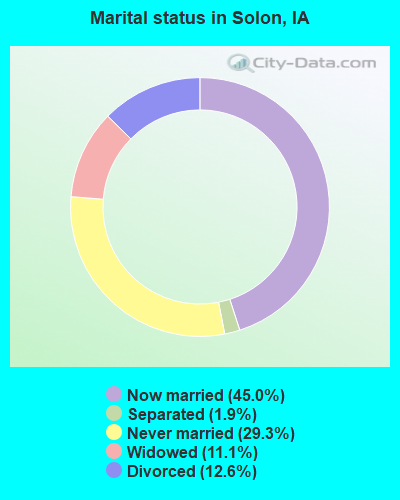
- Never married: 29.3%
- Now married: 45.0%
- Separated: 1.9%
- Widowed: 11.1%
- Divorced: 12.6%
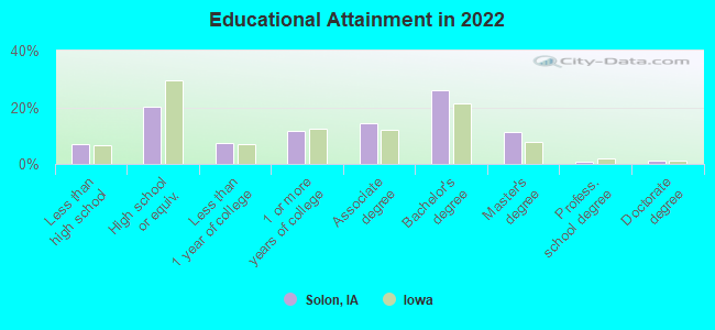
For population 25 years and over in Solon:
- High school or higher: 94.3%
- Bachelor's degree or higher: 39.6%
- Graduate or professional degree: 12.4%
- Unemployed: 1.5%
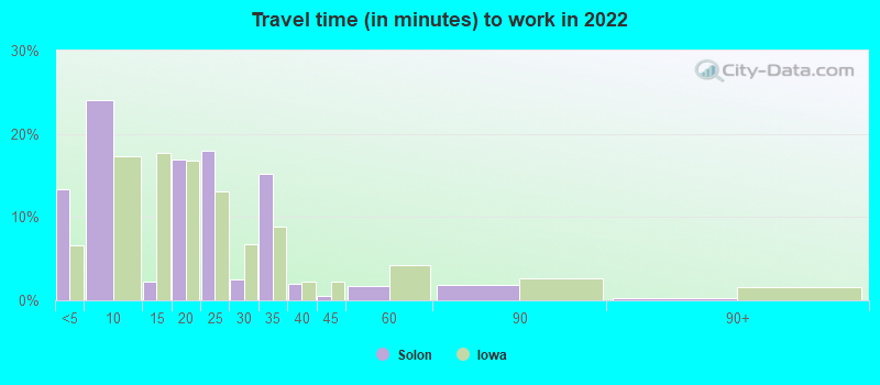
- Mean travel time to work (commute): 15.2 minutes
| Here: | 9.6 |
| Iowa average: | 10.5 |
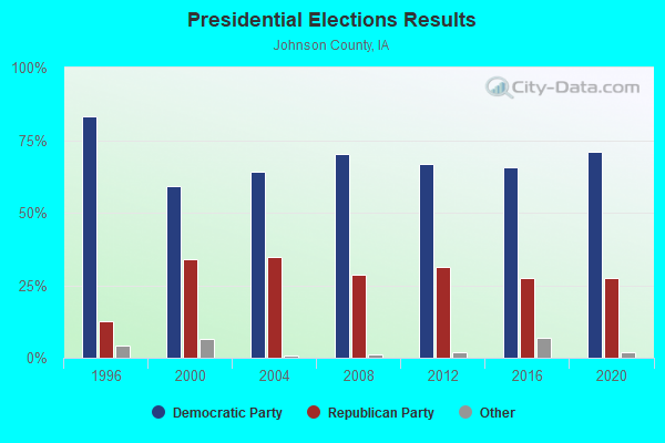
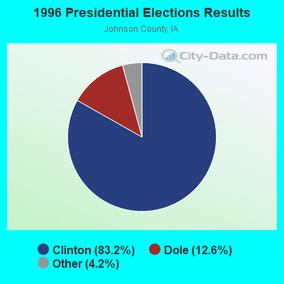
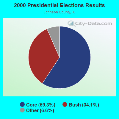

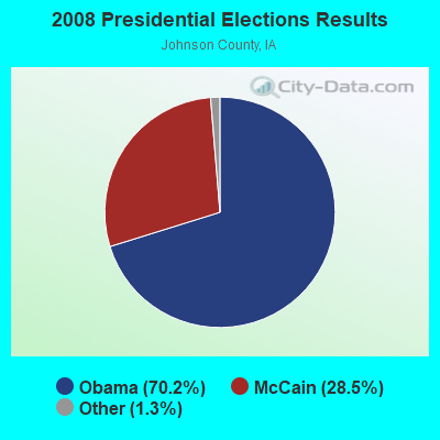
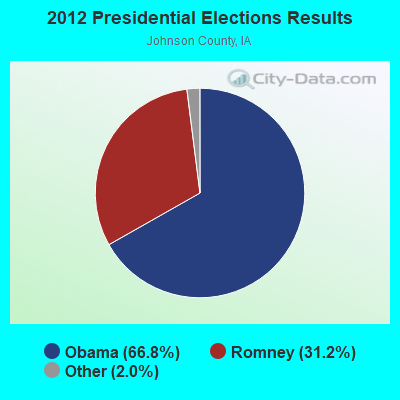

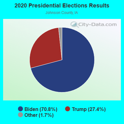
Graphs represent county-level data. Detailed 2008 Election Results
Neighborhoods in Solon:
(Solon, Iowa Neighborhood Map)- Apple Valley neighborhood
- Bramblewood Estates neighborhood
- Coral Heights neighborhood
- Coral Village Estates neighborhood
- Coralville Lake neighborhood
- Cottage Reserve in Lake Macbride Park neighborhood
- Green Acres neighborhood
- Hickory Heights neighborhood
- Hidden Acres neighborhood
- Hidden Valley Estates neighborhood
- Indian Hills neighborhood
- Lake Crest Manor neighborhood
- Lake Macbride Heights neighborhood
- Lake Point Estates neighborhood
- Lake View Ridge neighborhood
- Lakeview Knolls neighborhood
- Marshek neighborhood
- Meadow Ridge neighborhood
- Naxera Lake Macbride neighborhood
- North Coralville Lake Manor neighborhood
- North Twin View Heights neighborhood
- Old Mill Creek neighborhood
- Solon neighborhood
- Solon Estates neighborhood
- Sugar Maple Hills neighborhood
- Timber Point Estates neighborhood
- Twin Valley Lakes neighborhood
Religion statistics for Solon, IA (based on Johnson County data)
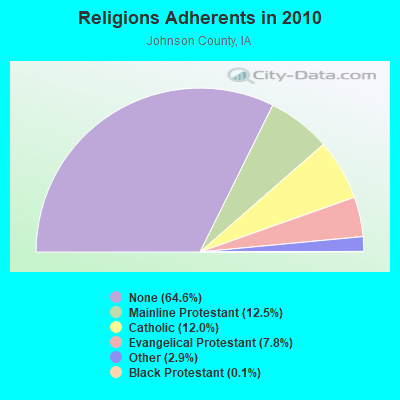

| Religion | Adherents | Congregations |
|---|---|---|
| Mainline Protestant | 16,310 | 32 |
| Catholic | 15,691 | 9 |
| Evangelical Protestant | 10,223 | 50 |
| Other | 3,756 | 17 |
| Black Protestant | 178 | 1 |
| Orthodox | 120 | 1 |
| None | 84,604 | - |
Food Environment Statistics:
| This county: | 2.07 / 10,000 pop. |
| State: | 2.14 / 10,000 pop. |
| This county: | 0.08 / 10,000 pop. |
| Iowa: | 0.23 / 10,000 pop. |
| Johnson County: | 0.32 / 10,000 pop. |
| State: | 0.43 / 10,000 pop. |
| Here: | 3.67 / 10,000 pop. |
| Iowa: | 5.55 / 10,000 pop. |
| Here: | 9.80 / 10,000 pop. |
| Iowa: | 8.01 / 10,000 pop. |
| Johnson County: | 5.3% |
| State: | 7.8% |
| Johnson County: | 22.1% |
| Iowa: | 27.3% |
| Here: | 11.4% |
| Iowa: | 14.5% |
Health and Nutrition:
| Solon: | 51.4% |
| Iowa: | 49.5% |
| This city: | 50.1% |
| State: | 46.1% |
| This city: | 28.9 |
| Iowa: | 28.6 |
| This city: | 19.3% |
| Iowa: | 21.4% |
| This city: | 8.4% |
| State: | 10.4% |
| This city: | 6.8 |
| State: | 6.8 |
| This city: | 35.9% |
| Iowa: | 33.8% |
| Solon: | 58.9% |
| Iowa: | 55.9% |
| Solon: | 79.2% |
| Iowa: | 77.7% |
More about Health and Nutrition of Solon, IA Residents
| Local government employment and payroll (March 2022) | |||||
| Function | Full-time employees | Monthly full-time payroll | Average yearly full-time wage | Part-time employees | Monthly part-time payroll |
|---|---|---|---|---|---|
| Local Libraries | 2 | $10,232 | $61,392 | 5 | $6,603 |
| Financial Administration | 2 | $12,925 | $77,550 | 0 | $0 |
| Other and Unallocable | 1 | $8,383 | $100,596 | 0 | $0 |
| Parks and Recreation | 1 | $4,526 | $54,312 | 0 | $0 |
| Water Supply | 1 | $4,065 | $48,780 | 0 | $0 |
| Sewerage | 1 | $5,943 | $71,316 | 0 | $0 |
| Streets and Highways | 1 | $5,401 | $64,812 | 0 | $0 |
| Other Government Administration | 0 | $0 | 1 | $526 | |
| Totals for Government | 9 | $51,476 | $68,635 | 6 | $7,129 |
Solon government finances - Expenditure in 2017 (per resident):
- Construction - Water Utilities: $285,000 ($90.48)
Regular Highways: $102,000 ($32.38)
- Current Operations - Regular Highways: $669,000 ($212.38)
Water Utilities: $434,000 ($137.78)
Sewerage: $429,000 ($136.19)
Libraries: $296,000 ($93.97)
Financial Administration: $289,000 ($91.75)
Parks and Recreation: $186,000 ($59.05)
General - Other: $164,000 ($52.06)
Solid Waste Management: $131,000 ($41.59)
Local Fire Protection: $74,000 ($23.49)
Police Protection: $74,000 ($23.49)
Judicial and Legal Services: $46,000 ($14.60)
Central Staff Services: $21,000 ($6.67)
Health - Other: $1,000 ($0.32)
- General - Interest on Debt: $174,000 ($55.24)
- Other Capital Outlay - Regular Highways: $61,000 ($19.37)
- Total Salaries and Wages: $558,000 ($177.14)
- Water Utilities - Interest on Debt: $61,000 ($19.37)
Solon government finances - Revenue in 2017 (per resident):
- Charges - Sewerage: $540,000 ($171.43)
Solid Waste Management: $148,000 ($46.98)
Parks and Recreation: $67,000 ($21.27)
Other: $45,000 ($14.29)
Regular Highways: $5,000 ($1.59)
- Local Intergovernmental - Other: $120,000 ($38.10)
- Miscellaneous - General Revenue - Other: $114,000 ($36.19)
Rents: $19,000 ($6.03)
Interest Earnings: $17,000 ($5.40)
Sale of Property: $14,000 ($4.44)
- Revenue - Water Utilities: $419,000 ($133.02)
- State Intergovernmental - Highways: $253,000 ($80.32)
Other: $2,000 ($0.63)
- Tax - Property: $1,610,000 ($511.11)
General Sales and Gross Receipts: $920,000 ($292.06)
Other License: $210,000 ($66.67)
Public Utilities Sales: $15,000 ($4.76)
Solon government finances - Debt in 2017 (per resident):
- Long Term Debt - Beginning Outstanding - Unspecified Public Purpose: $5,876,000 ($1865.40)
Outstanding Unspecified Public Purpose: $5,552,000 ($1762.54)
Retired Unspecified Public Purpose: $324,000 ($102.86)
Solon government finances - Cash and Securities in 2017 (per resident):
- Other Funds - Cash and Securities: $4,133,000 ($1312.06)
Businesses in Solon, IA
- Dairy Queen: 1
- U-Haul: 1
Strongest AM radio stations in Solon:
- KCJJ (1630 AM; 10 kW; IOWA CITY, IA; Owner: RIVER CITY RADIO, INC.)
- WMT (600 AM; 5 kW; CEDAR RAPIDS, IA; Owner: CITICASTERS LICENSES, L.P.)
- KCRG (1600 AM; 5 kW; CEDAR RAPIDS, IA; Owner: CEDAR RAPIDS TELEVISION CO.)
- KXIC (800 AM; 1 kW; IOWA CITY, IA; Owner: CITICASTERS LICENSES, L.P.)
- WSUI (910 AM; 5 kW; IOWA CITY, IA; Owner: THE UNIVERSITY OF IOWA)
- KXEL (1540 AM; 50 kW; WATERLOO, IA; Owner: KXEL BROADCASTING COMPANY, INC.)
- KMJM (1360 AM; 1 kW; CEDAR RAPIDS, IA; Owner: CAPSTAR TX LIMITED PARTNERSHIP)
- WHO (1040 AM; 50 kW; DES MOINES, IA; Owner: CITICASTERS LICENSES, L.P.)
- WSCR (670 AM; 50 kW; CHICAGO, IL; Owner: INFINITY BROADCASTING OPERATIONS, INC.)
- KMRY (1450 AM; 1 kW; CEDAR RAPIDS, IA; Owner: SELLERS BROADCASTING, INC.)
- WTMJ (620 AM; 50 kW; MILWAUKEE, WI; Owner: JOURNAL BROADCAST CORPORATION)
- WGN (720 AM; 50 kW; CHICAGO, IL; Owner: WGN CONTINENTAL BROADCASTING CO.)
- WBBM (780 AM; 50 kW; CHICAGO, IL; Owner: INFINITY BROADCASTING OPERATIONS, INC.)
Strongest FM radio stations in Solon:
- KKRQ (100.7 FM; IOWA CITY, IA; Owner: CITICASTERS LICENSES, L.P.)
- KSUI (91.7 FM; IOWA CITY, IA; Owner: THE UNIVERSITY OF IOWA)
- KHAK (98.1 FM; CEDAR RAPIDS, IA; Owner: CUMULUS LICENSING CORP.)
- KRNA (94.1 FM; IOWA CITY, IA; Owner: CUMULUS LICENSING CORP.)
- KCCK-FM (88.3 FM; CEDAR RAPIDS, IA; Owner: KIRKWOOD COMMUNITY COLLEGE)
- KDAT (104.5 FM; CEDAR RAPIDS, IA; Owner: CUMULUS LICENSING CORP.)
- KZIA (102.9 FM; CEDAR RAPIDS, IA; Owner: KZIA, INC.)
- K295AC (106.9 FM; IOWA CITY, IA; Owner: KIRKWOOD COMMUNITY COLLEGE)
- KUNI (90.9 FM; CEDAR FALLS, IA; Owner: UNIVERSITY OF NORTHERN IOWA)
- WMT-FM (96.5 FM; CEDAR RAPIDS, IA; Owner: CITICASTERS LICENSES, L.P.)
- KFMW (107.9 FM; WATERLOO, IA; Owner: KXEL BROADCASTING COMPANY, INC.)
- KRNL-FM (89.7 FM; MOUNT VERNON, IA; Owner: CORNELL COLLEGE)
- KBEA-FM (99.7 FM; MUSCATINE, IA; Owner: CUMULUS LICENSING CORP.)
- KRUI-FM (89.7 FM; IOWA CITY, IA; Owner: STUDENT B/CASTERS, INCORP.)
TV broadcast stations around Solon:
- KWKB (Channel 20; IOWA CITY, IA; Owner: KM TELEVISION OF IOWA, L.L.C.)
- KIIN (Channel 12; IOWA CITY, IA; Owner: IOWA PUBLIC BROADCASTING BOARD)
- KFXA (Channel 28; CEDAR RAPIDS, IA; Owner: SECOND GENERATION OF IOWA, LTD.)
- K64DG (Channel 64; IOWA CITY, IA; Owner: R B SHELDAHL)
- KGAN (Channel 2; CEDAR RAPIDS, IA; Owner: KGAN LICENSEE, LLC)
- KCRG-TV (Channel 9; CEDAR RAPIDS, IA; Owner: CEDAR RAPIDS TELEVISION CO.)
- KWWL (Channel 7; WATERLOO, IA; Owner: RAYCOM AMERICA, INC.)
- KRIN (Channel 32; WATERLOO, IA; Owner: IOWA PUBLIC BROADCASTING BOARD)
- KCDE-LP (Channel 67; CEDAR RAPIDS, IA; Owner: TIGER EYE BROADCASTING CORPORATION)
- KCDR-LP (Channel 55; CEDAR RAPIDS, IA; Owner: TIGER EYE BROADCASTING CORPORATION)
- KHHH-LP (Channel 57; CEDAR RAPIDS, IA; Owner: TIGER EYE BROADCASTING CORPORATION)
- KRUB-LP (Channel 65; CEDAR RAPIDS, IA; Owner: TIGER EYE BROADCASTING CORPORATION)
- K17ET (Channel 17; CEDAR RAPIDS, IA; Owner: TRINITY BROADCASTING NETWORK)
- K16EL (Channel 66; DAVENPORT, IA; Owner: THREE ANGELS BROADCASTING NETWORK)
- KPXR (Channel 48; CEDAR RAPIDS, IA; Owner: PAXSON COMMUNICATIONS LICENSE COMPANY, LLC)
Solon fatal accident list:
- National Bridge Inventory (NBI) Statistics
- 10Number of bridges
- 46ft / 14.1mTotal length
- 22,000Total average daily traffic
- 1,420Total average daily truck traffic
- 22,000Total future (year 2040) average daily traffic
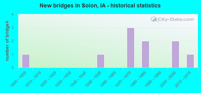
- New bridges - historical statistics
- 11900-1909
- 11950-1959
- 31970-1979
- 21980-1989
- 22000-2009
- 12010-2019
FCC Registered Cell Phone Towers:
2 (See the full list of FCC Registered Cell Phone Towers in Solon)FCC Registered Antenna Towers:
47 (See the full list of FCC Registered Antenna Towers)FCC Registered Commercial Land Mobile Towers:
2- 4 Mi. S. Of Solon (Lat: 41.757250 Lon: -91.525444), Structure height: 151 m, Call Sign: KPJ457, Licensee ID: L00374390,
Assigned Frequencies: 450.150 MHz, Grant Date: 01/15/1988, Expiration Date: 02/01/1997, Cancellation Date: 09/24/2000, Registrant: Iowa City Broadcasting, Inc., Iowa City, IA 52244
- Lat: 41.757222 Lon: -91.525556, Call Sign: WQMI290,
Assigned Frequencies: 450.150 MHz, Grant Date: 08/12/2010, Expiration Date: 02/01/2029, Certifier: Stephen G Davis, Registrant: Iheartmedia, Inc., 7136 S. Yale Avenue, Suite 501, Tulsa, OK 74136, Phone: (918) 664-4581, Fax: (918) 664-3066, Email:
FCC Registered Private Land Mobile Towers:
1- 4804 210th St. Ne (Lat: 41.781111 Lon: -91.462222), Type: Tower, Structure height: 103.6 m, Overall height: 112.8 m, Call Sign: WPXJ985,
Assigned Frequencies: 861.362 MHz, 861.387 MHz, 861.462 MHz, 861.662 MHz, 861.887 MHz, 861.962 MHz, 862.237 MHz, 862.362 MHz, 862.387 MHz, 862.462 MHz... (+15 more), Grant Date: 04/21/2003, Expiration Date: 04/21/2013, Cancellation Date: 07/12/2012, Certifier: Mary E Julius, Registrant: Sprint Nextel Corporation, 12502 Sunrise Valley Drive, M/S: Varesa0209, Reston, VA 20196, Phone: (703) 433-4000, Fax: (703) 433-4483
FCC Registered Broadcast Land Mobile Towers:
3- SOLON, 4080 Highway 382 (Lat: 41.822056 Lon: -91.532306), Call Sign: WQWB826,
Assigned Frequencies: 468.862 MHz, Grant Date: 07/13/2015, Expiration Date: 07/13/2025, Certifier: Kevin Shima, Registrant: Business Radio Sales & Service Inc., 1418 5th Street, Coralville, IA 52241, Phone: (319) 354-2204, Fax: (319) 351-2938, Email:
- Lat: 41.805333 Lon: -91.495750, Call Sign: WQXL914,
Assigned Frequencies: 72.2400 MHz, Grant Date: 04/12/2016, Expiration Date: 04/12/2026, Certifier: Davis Eidahl, Registrant: Primex Wireless Inc, 965 Wells St., Lake Geneva, WI 53147, Phone: (800) 537-0464
- Lat: 41.773361 Lon: -91.507028, Call Sign: WQYJ772,
Assigned Frequencies: 461.637 MHz, Grant Date: 10/19/2016, Expiration Date: 10/19/2026, Certifier: Brad Dvorsky, Registrant: Business Radio Sales & Service Inc., 1418 5th Street, Coralville, IA 52241, Phone: (319) 354-2204, Fax: (319) 351-2938, Email:
FCC Registered Microwave Towers:
5- SOLON, 1896 Racine Avenue Ne (Lat: 41.795694 Lon: -91.500389), Type: Tower, Structure height: 61 m, Overall height: 65.5 m, Call Sign: WPQT877,
Assigned Frequencies: 6785.00 MHz, 6745.00 MHz, Grant Date: 09/21/2010, Expiration Date: 10/18/2020, Cancellation Date: 11/25/2015, Certifier: Steven T Campbell, Registrant: Holland & Knight LLP, 800 17th Street, N.W., Suite #1100, Washington, DC 20006-3906, Phone: (202) 955-3000, Fax: (202) 955-5564, Email:
- SOLON, Lat: 41.806694 Lon: -91.518111, Call Sign: WPSQ270, Licensee ID: L00353561,
Assigned Frequencies: 956.431 MHz, Grant Date: 04/12/2011, Expiration Date: 07/09/2021, Cancellation Date: 10/09/2021, Certifier: Brandy Forbes, Registrant: City Of Solon
- SOLON, 4804 210th Street Ne (Lat: 41.781000 Lon: -91.462250), Type: Tower, Structure height: 103.6 m, Overall height: 112.8 m, Call Sign: WQKU668,
Assigned Frequencies: 6685.00 MHz, 5974.85 MHz, Grant Date: 06/22/2019, Expiration Date: 09/18/2029, Certifier: Dave C Wilson, Registrant: Racom Corp., 201 West State Street, Marshalltown, IA 50158, Phone: (888) 752-1016, Fax: (641) 752-0674, Email:
- DM03IP639, 2184 Saint Bridgets Rd Ne (Lat: 41.773889 Lon: -91.373194), Type: Building, Structure height: 66.8 m, Call Sign: WQWT647,
Assigned Frequencies: 10955.0 MHz, 10955.0 MHz, 10955.0 MHz, 10955.0 MHz, 10955.0 MHz, 10955.0 MHz, 10955.0 MHz, Grant Date: 11/16/2015, Expiration Date: 11/16/2025, Certifier: David Werblow, Registrant: Dla Piper LLP, 500 8th Street, Nw, Washington, DC 20004, Phone: (202) 799-4216, Fax: (202) 799-5616, Email:
- WS-SOLN-RL01, 5003 160th St Ne (Lat: 41.816389 Lon: -91.444722), Type: Mtower, Structure height: 30.5 m, Call Sign: WRED413,
Assigned Frequencies: 11405.0 MHz, 11405.0 MHz, 11405.0 MHz, 11405.0 MHz, 11405.0 MHz, 11405.0 MHz, 11405.0 MHz, 11405.0 MHz, 11405.0 MHz, 11405.0 MHz, Grant Date: 09/24/2019, Expiration Date: 09/24/2029, Certifier: Brian Corman, Registrant: Bob, LLC Dba Business Only Broadband, 999 Oak Creek Drive, Lombard, IL 60148, Phone: (630) 590-6006, Email:
FCC Registered Amateur Radio Licenses:
35 (See the full list of FCC Registered Amateur Radio Licenses in Solon)FAA Registered Aircraft Manufacturers and Dealers:
1 (See the full list of FAA Registered Manufacturers and Dealers in Solon)FAA Registered Aircraft:
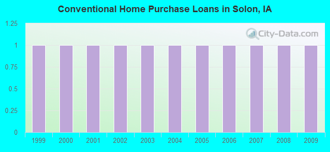
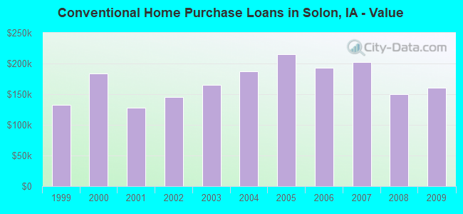
7 (See the full list of FAA Registered Aircraft)| Home Mortgage Disclosure Act Aggregated Statistics For Year 2009 (Based on 1 partial tract) | ||||
| B) Conventional Home Purchase Loans | C) Refinancings | |||
|---|---|---|---|---|
| Number | Average Value | Number | Average Value | |
| LOANS ORIGINATED | 1 | $160,260 | 4 | $176,988 |
| APPLICATIONS APPROVED, NOT ACCEPTED | 0 | $0 | 0 | $0 |
| APPLICATIONS DENIED | 0 | $0 | 1 | $121,790 |
| APPLICATIONS WITHDRAWN | 0 | $0 | 0 | $0 |
| FILES CLOSED FOR INCOMPLETENESS | 0 | $0 | 0 | $0 |
Detailed HMDA statistics for the following Tracts: 0101.00
2002 - 2018 National Fire Incident Reporting System (NFIRS) incidents
- Fire incident types reported to NFIRS in Solon, IA
- 17246.4%Outside Fires
- 14539.1%Structure Fires
- 4010.8%Mobile Property/Vehicle Fires
- 143.8%Other
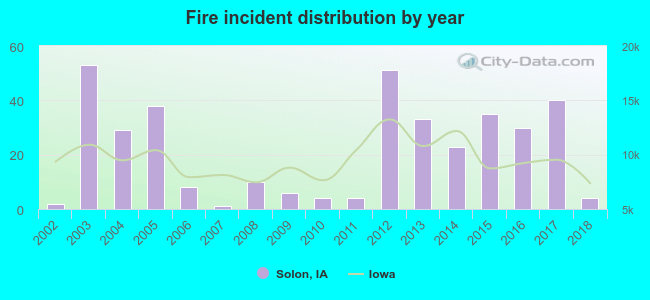 According to the data from the years 2002 - 2018 the average number of fire incidents per year is 22. The highest number of reported fires - 53 took place in 2003, and the least - 1 in 2007. The data has a growing trend.
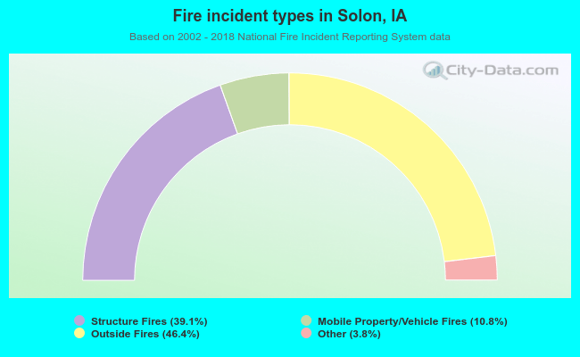 When looking into fire subcategories, the most reports belonged to: Outside Fires (46.4%), and Structure Fires (39.1%).
| Most common first names in Solon, IA among deceased individuals | ||
| Name | Count | Lived (average) |
|---|---|---|
| John | 26 | 79.4 years |
| Mary | 26 | 82.9 years |
| James | 20 | 68.7 years |
| Frank | 19 | 84.1 years |
| Joseph | 18 | 78.8 years |
| Charles | 18 | 79.1 years |
| Robert | 16 | 77.2 years |
| William | 16 | 79.2 years |
| Anna | 15 | 86.5 years |
| Helen | 15 | 85.3 years |
| Most common last names in Solon, IA among deceased individuals | ||
| Last name | Count | Lived (average) |
|---|---|---|
| Kessler | 21 | 84.0 years |
| Dvorsky | 13 | 81.0 years |
| Miller | 12 | 71.2 years |
| Brown | 11 | 77.4 years |
| Randall | 9 | 79.6 years |
| Krob | 8 | 84.9 years |
| Stahle | 8 | 78.7 years |
| Phillips | 8 | 73.1 years |
| Miltner | 7 | 77.1 years |
| Sovers | 7 | 82.2 years |
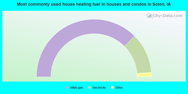
- 75.0%Utility gas
- 22.6%Electricity
- 0.9%Other fuel
- 0.6%Coal or coke
- 0.6%No fuel used
- 0.4%Bottled, tank, or LP gas
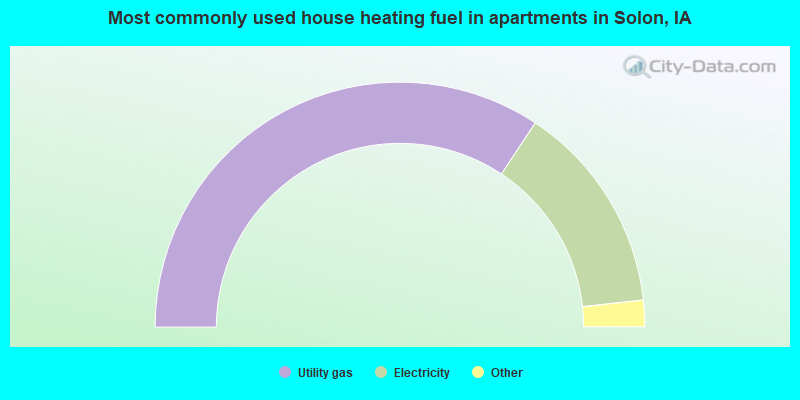
- 68.7%Utility gas
- 27.9%Electricity
- 2.2%Other fuel
- 1.1%Bottled, tank, or LP gas
Solon compared to Iowa state average:
- Median household income above state average.
- Unemployed percentage significantly below state average.
- Black race population percentage significantly below state average.
- Hispanic race population percentage below state average.
- Median age significantly below state average.
- Foreign-born population percentage significantly below state average.
- Length of stay since moving in significantly above state average.
- House age significantly below state average.
- Institutionalized population percentage above state average.
- Number of college students above state average.
- Percentage of population with a bachelor's degree or higher above state average.

|
|
Total of 81 patent applications in 2008-2024.