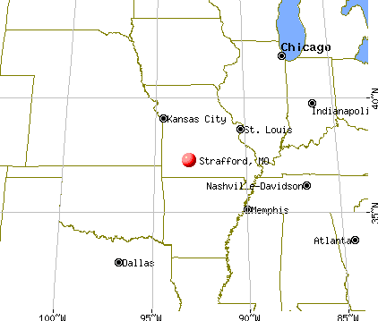
Strafford, Missouri
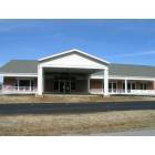
Strafford: Strafford senior center
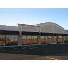
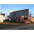
Strafford: a new retail/office center was recently completed in Strafford providing the opportunity to business growth
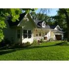
Strafford: Beautiful Strafford Home

Strafford: new homes are being built on Strafford southside as part of an affordable housing grant

Strafford: The Strafford Fire Protection District recently opened their fouth station. The station will help homeowners in the area with insurance rates. The fire district recently received their new ISO rating and are one of only a few all volunteer departments to receive a 4 rating. The 4 rating is for inside the city limits, outside the city is a class 6 which is extrremely good for a small volunteer department
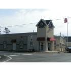
Strafford: Strafford city offices recently moved into a new city hall complex. The building is the first time that the city has owed and not rented their office space
Strafford: construction is underway on the Strafford School campus as a new 500 seat state-of -the-art auditorium is set to open in the spring of 2006
- add
your
Submit your own pictures of this city and show them to the world
- OSM Map
- General Map
- Google Map
- MSN Map
Population change since 2000: +43.3%
| Males: 1,276 | |
| Females: 1,367 |
| Median resident age: | 35.5 years |
| Missouri median age: | 39.1 years |
Zip codes: 65757.
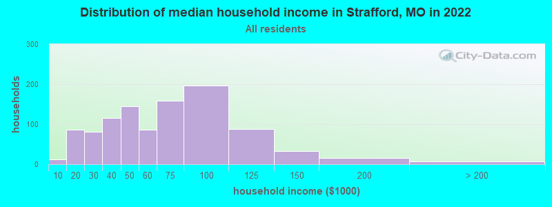
| Strafford: | $57,401 |
| MO: | $64,811 |
Estimated per capita income in 2022: $24,912 (it was $14,858 in 2000)
Strafford city income, earnings, and wages data
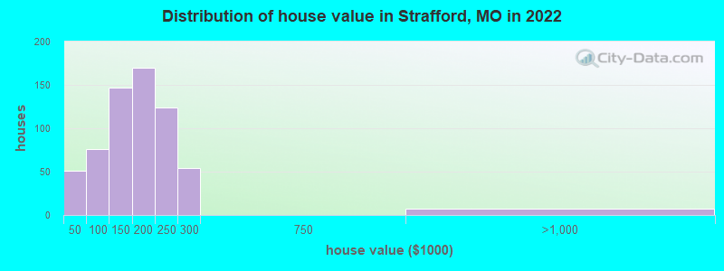
Estimated median house or condo value in 2022: $177,713 (it was $80,800 in 2000)
| Strafford: | $177,713 |
| MO: | $221,200 |
Mean prices in 2022: all housing units: $234,963; detached houses: $241,316; townhouses or other attached units: $242,953; in 2-unit structures: $130,625; in 3-to-4-unit structures: $146,710; in 5-or-more-unit structures: $236,353; mobile homes: $62,031; occupied boats, rvs, vans, etc.: $40,788
Median gross rent in 2022: $933.
(16.4% for White Non-Hispanic residents, 12.4% for Hispanic or Latino residents, 100.0% for American Indian residents, 17.3% for two or more races residents)
Detailed information about poverty and poor residents in Strafford, MO


Compare current foreclosures near Strafford, MO:
| Photo | Address | Area | Beds / Baths | Price | Details |
|---|---|---|---|---|---|

|
#1
E Division St
Strafford, MO 65757
|
1,624 sq. feet
|
2 baths 3 beds |
show details | |

|
#2
S Wrenwood St
Strafford, MO 65757
|
1,412 sq. feet
|
2 baths 3 beds |
show details | |

|
#3
S Old Orchard Dr
Strafford, MO 65757
|
1,030 sq. feet
|
1 baths 3 beds |
show details | |

|
#4
E Osage St
Strafford, MO 65757
|
1,266 sq. feet
|
2 baths 3 beds |
show details | |

|
#5
E Rosalie
Strafford, MO 65757
|
- sq. feet
|
- baths - beds |
show details | |

|
#6
E Seminole St
Strafford, MO 65757
|
- sq. feet
|
- baths - beds |
show details | |

|
#7
S Sunmeadow Dr
Strafford, MO 65757
|
- sq. feet
|
- baths - beds |
show details | |

|
#8
E Shawnee St
Strafford, MO 65757
|
- sq. feet
|
- baths - beds |
show details | |

|
#9
S Lincoln Ave
Strafford, MO 65757
|
- sq. feet
|
- baths - beds |
show details | |

|
#10
W Harrison St
Springfield, MO 65802
|
1,011 sq. feet
|
2 baths 2 beds |
$153,000
|
show details |
| Photo | Address | Area | Beds / Baths | Price | Details |
|---|---|---|---|---|---|

|
#11
N Main Ave
Springfield, MO 65803
|
2,401 sq. feet
|
2 baths 3 beds |
$87,500
|
show details |

|
#12
N Nettleton Ave
Springfield, MO 65802
|
768 sq. feet
|
1 baths 2 beds |
$129,900
|
show details |

|
#13
Ridgeview Rd
Pleasant Hope, MO 65725
|
1,431 sq. feet
|
3 baths 3 beds |
show details | |

|
#14
N Pierce Ave
Springfield, MO 65803
|
1,552 sq. feet
|
1 baths 3 beds |
show details | |

|
#15
E Farm Rd 84
Springfield, MO 65803
|
1,376 sq. feet
|
1 baths 3 beds |
show details | |

|
#16
S Missouri Ave
Springfield, MO 65806
|
1,202 sq. feet
|
2 baths 2 beds |
show details | |

|
#17
S Stonegate Ave
Springfield, MO 65810
|
1,316 sq. feet
|
2 baths 3 beds |
show details | |

|
#18
E Barcelona Pl
Springfield, MO 65804
|
2,262 sq. feet
|
2 baths 2 beds |
show details | |

|
#19
W Jeremy Ct
Springfield, MO 65807
|
2,524 sq. feet
|
2 baths 4 beds |
show details | |

|
#20
Slater Rd
Buffalo, MO 65622
|
1,008 sq. feet
|
1 baths 1 beds |
show details |
| Photo | Address | Area | Beds / Baths | Price | Details |
|---|---|---|---|---|---|

|
#21
S Mahn Ave
Springfield, MO 65802
|
1,349 sq. feet
|
2 baths 3 beds |
show details | |

|
#22
N Lone Pine Ave
Springfield, MO 65802
|
1,497 sq. feet
|
1 baths 3 beds |
show details | |

|
#23
Berry Ln
Willard, MO 65781
|
2,446 sq. feet
|
3 baths 5 beds |
show details | |

|
#24
Hill St
Willard, MO 65781
|
1,008 sq. feet
|
2 baths 3 beds |
show details | |

|
#25
N Taylor Ave
Springfield, MO 65803
|
766 sq. feet
|
1 baths 3 beds |
show details | |

|
#26
S Honeysuckle Ln
Brookline Station, MO 65619
|
2,398 sq. feet
|
3 baths 4 beds |
show details | |

|
#27
E Crestview St
Springfield, MO 65804
|
1,191 sq. feet
|
1 baths 3 beds |
show details | |

|
#28
S Timbercreek Ave
Springfield, MO 65807
|
1,585 sq. feet
|
2 baths 3 beds |
show details | |

|
#29
N Elizabeth Ave
Springfield, MO 65803
|
1,294 sq. feet
|
1 baths 3 beds |
show details | |

|
#30
S Cottage Ave
Springfield, MO 65807
|
1,650 sq. feet
|
2 baths 3 beds |
show details |
| Photo | Address | Area | Beds / Baths | Price | Details |
|---|---|---|---|---|---|

|
#31
S Shady Lane Ct
Springfield, MO 65810
|
1,608 sq. feet
|
2 baths 3 beds |
show details | |

|
#32
E Mcgee St
Springfield, MO 65807
|
1,092 sq. feet
|
1 baths 2 beds |
show details | |

|
#33
W Rockwood St
Springfield, MO 65807
|
1,405 sq. feet
|
2 baths 3 beds |
show details | |

|
#34
S Farm Road 123
Springfield, MO 65807
|
1,337 sq. feet
|
2 baths 3 beds |
show details | |

|
#35
W Dale St
Springfield, MO 65803
|
1,026 sq. feet
|
1 baths 2 beds |
show details | |

|
#36
W Page St
Springfield, MO 65802
|
900 sq. feet
|
1 baths 2 beds |
show details | |

|
#37
S Keystone Ave
Springfield, MO 65807
|
1,335 sq. feet
|
2 baths 3 beds |
show details | |

|
#38
E Berkeley St
Springfield, MO 65804
|
1,548 sq. feet
|
1 baths 3 beds |
show details | |

|
#39
W Washita St
Springfield, MO 65807
|
2,016 sq. feet
|
2 baths 2 beds |
show details | |

|
#40
W Webster St
Springfield, MO 65802
|
1,058 sq. feet
|
1 baths 3 beds |
show details |
| Photo | Address | Area | Beds / Baths | Price | Details |
|---|---|---|---|---|---|

|
#41
N Tyler Ave
Springfield, MO 65802
|
1,144 sq. feet
|
1 baths 3 beds |
show details | |

|
#42
W Woodland St
Springfield, MO 65807
|
2,336 sq. feet
|
3 baths 4 beds |
show details | |

|
#43
E Weaver Rd
Springfield, MO 65810
|
2,754 sq. feet
|
2 baths 4 beds |
show details | |

|
#44
N Johnston Ave
Springfield, MO 65803
|
1,878 sq. feet
|
2 baths 5 beds |
show details | |

|
#45
S Golden Ave
Springfield, MO 65807
|
1,299 sq. feet
|
2 baths 3 beds |
show details | |

|
#46
W Katella Ct
Springfield, MO 65807
|
1,651 sq. feet
|
2 baths 3 beds |
show details | |

|
#47
S Westwood Ave
Springfield, MO 65807
|
1,360 sq. feet
|
2 baths 3 beds |
show details | |

|
#48
E Bennett St
Springfield, MO 65804
|
1,044 sq. feet
|
1 baths 2 beds |
show details | |

|
#49
N Farm Road 155
Springfield, MO 65803
|
1,438 sq. feet
|
2 baths 3 beds |
show details | |

|
Check over 1 million property listings on Foreclosure.com!
|
browse all offers | |||


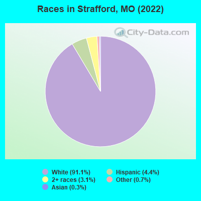
- 2,37391.1%White alone
- 1154.4%Hispanic
- 803.1%Two or more races
- 190.7%Other race alone
- 90.3%Asian alone
Races in Strafford detailed stats: ancestries, foreign born residents, place of birth
According to our research of Missouri and other state lists, there were 26 registered sex offenders living in Strafford, Missouri as of May 15, 2024.
The ratio of all residents to sex offenders in Strafford is 84 to 1.
Type |
2009 |
2010 |
2011 |
2012 |
2013 |
2014 |
2015 |
2016 |
2017 |
2018 |
2019 |
2020 |
2021 |
2022 |
|---|---|---|---|---|---|---|---|---|---|---|---|---|---|---|
| Murders (per 100,000) | 0 (0.0) | 0 (0.0) | 0 (0.0) | 0 (0.0) | 0 (0.0) | 0 (0.0) | 0 (0.0) | 0 (0.0) | 0 (0.0) | 0 (0.0) | 0 (0.0) | 0 (0.0) | 0 (0.0) | 0 (0.0) |
| Rapes (per 100,000) | 0 (0.0) | 0 (0.0) | 0 (0.0) | 0 (0.0) | 1 (42.2) | 1 (42.1) | 0 (0.0) | 0 (0.0) | 0 (0.0) | 0 (0.0) | 0 (0.0) | 1 (40.4) | 1 (39.7) | 1 (38.0) |
| Robberies (per 100,000) | 0 (0.0) | 1 (42.4) | 0 (0.0) | 1 (42.0) | 0 (0.0) | 1 (42.1) | 0 (0.0) | 0 (0.0) | 1 (42.7) | 1 (41.5) | 0 (0.0) | 0 (0.0) | 0 (0.0) | 0 (0.0) |
| Assaults (per 100,000) | 1 (45.1) | 6 (254.5) | 0 (0.0) | 3 (126.1) | 7 (295.1) | 4 (168.6) | 1 (42.1) | 4 (169.1) | 2 (85.4) | 4 (166.1) | 1 (40.4) | 3 (121.3) | 3 (119.1) | 3 (113.9) |
| Burglaries (per 100,000) | 18 (811.5) | 14 (593.7) | 7 (295.7) | 11 (462.4) | 10 (421.6) | 16 (674.3) | 9 (379.3) | 6 (253.6) | 8 (341.7) | 13 (539.9) | 7 (282.6) | 13 (525.7) | 4 (158.9) | 5 (189.9) |
| Thefts (per 100,000) | 99 (4,463) | 105 (4,453) | 96 (4,056) | 104 (4,372) | 71 (2,993) | 69 (2,908) | 54 (2,276) | 69 (2,916) | 52 (2,221) | 47 (1,952) | 30 (1,211) | 47 (1,901) | 60 (2,383) | 51 (1,937) |
| Auto thefts (per 100,000) | 4 (180.3) | 7 (296.9) | 2 (84.5) | 3 (126.1) | 1 (42.2) | 3 (126.4) | 1 (42.1) | 9 (380.4) | 9 (384.5) | 3 (124.6) | 9 (363.3) | 8 (323.5) | 14 (556.0) | 12 (455.8) |
| Arson (per 100,000) | 0 (0.0) | 0 (0.0) | 0 (0.0) | 0 (0.0) | 1 (42.2) | 0 (0.0) | 0 (0.0) | 0 (0.0) | 0 (0.0) | 0 (0.0) | 0 (0.0) | 0 (0.0) | 0 (0.0) | 0 (0.0) |
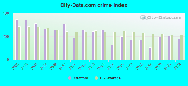
| City-Data.com crime index | 258.8 | 307.0 | 189.7 | 255.1 | 245.4 | 253.7 | 129.4 | 198.6 | 173.4 | 171.5 | 105.4 | 195.3 | 206.5 | 180.4 |
The City-Data.com crime index weighs serious crimes and violent crimes more heavily. Higher means more crime, U.S. average is 246.1. It adjusts for the number of visitors and daily workers commuting into cities.
Crime rate in Strafford detailed stats: murders, rapes, robberies, assaults, burglaries, thefts, arson
Full-time law enforcement employees in 2019, including police officers: 6 (6 officers - 5 male; 1 female).
| Officers per 1,000 residents here: | 2.42 |
| Missouri average: | 2.48 |
 Recent articles from our blog. Our writers, many of them Ph.D. graduates or candidates, create easy-to-read articles on a wide variety of topics.

 | looking for internet in Strafford (3 replies) |
| small towns in the area (8 replies) |
| Springfield, MO is calling to me (115 replies) |
| Moving to Springfield area soon. Questions (7 replies) |
| Springfield (area) vs. Columbia (area) (1 reply) |
| Moving to the area in 2018 (5 replies) |
Latest news from Strafford, MO collected exclusively by city-data.com from local newspapers, TV, and radio stations
Strafford, MO City Guides:
Ancestries: American (18.1%), German (12.5%), English (8.1%), European (7.6%), Irish (5.8%), Scotch-Irish (5.2%).
Current Local Time: CST time zone
Incorporated in 1968
Elevation: 1482 feet
Land area: 2.34 square miles.
Population density: 1,132 people per square mile (low).
31 residents are foreign born
| This city: | 1.2% |
| Missouri: | 4.2% |
Median real estate property taxes paid for housing units with mortgages in 2022: $1,384 (0.8%)
Median real estate property taxes paid for housing units with no mortgage in 2022: $1,059 (0.7%)
Nearest city with pop. 50,000+: Springfield, MO  (10.4 miles , pop. 151,580).
Nearest city with pop. 200,000+: Kansas City, MO (147.3 miles , pop. 441,545).
Nearest city with pop. 1,000,000+: Dallas, TX (372.3 miles , pop. 1,188,580).
Nearest cities:
), )Latitude: 37.27 N, Longitude: 93.12 W
Area code: 417

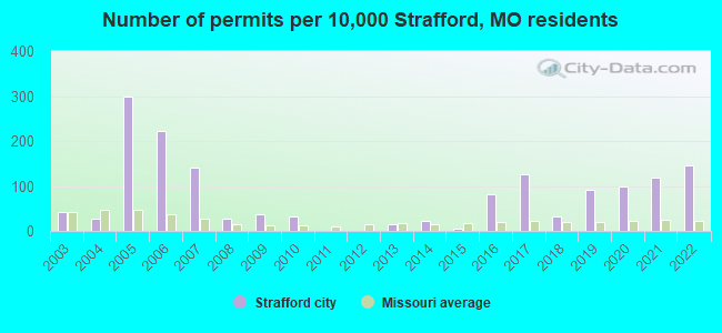
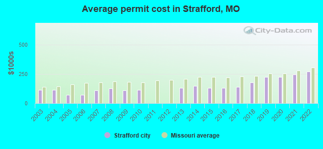
Single-family new house construction building permits:
- 2022: 27 buildings, average cost: $273,300
- 2021: 22 buildings, average cost: $244,800
- 2020: 18 buildings, average cost: $226,000
- 2019: 17 buildings, average cost: $226,000
- 2018: 6 buildings, average cost: $180,000
- 2017: 23 buildings, average cost: $139,100
- 2016: 15 buildings, average cost: $130,000
- 2015: 1 building, cost: $130,000
- 2014: 4 buildings, average cost: $150,000
- 2013: 3 buildings, average cost: $133,300
- 2010: 6 buildings, average cost: $115,800
- 2009: 7 buildings, average cost: $112,100
- 2008: 5 buildings, average cost: $126,000
- 2007: 26 buildings, average cost: $112,000
- 2006: 41 buildings, average cost: $71,000
- 2005: 55 buildings, average cost: $71,000
- 2004: 5 buildings, average cost: $113,700
- 2003: 8 buildings, average cost: $113,700
| Here: | 2.3% |
| Missouri: | 2.8% |
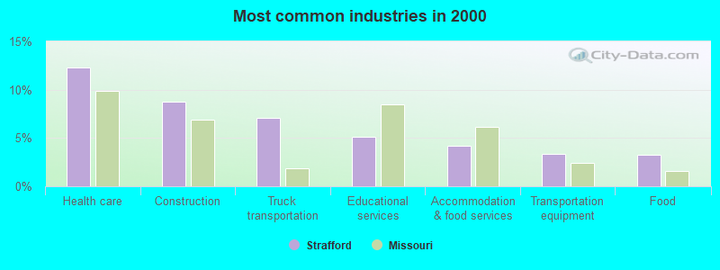
- Health care (12.3%)
- Construction (8.7%)
- Truck transportation (7.1%)
- Educational services (5.1%)
- Accommodation & food services (4.2%)
- Transportation equipment (3.4%)
- Food (3.3%)
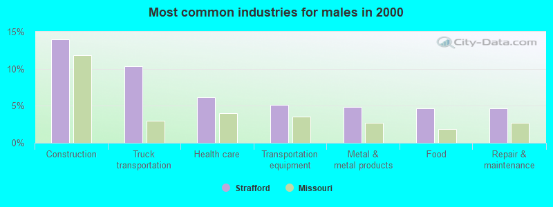
- Construction (14.0%)
- Truck transportation (10.4%)
- Health care (6.1%)
- Transportation equipment (5.1%)
- Metal & metal products (4.9%)
- Food (4.7%)
- Repair & maintenance (4.7%)
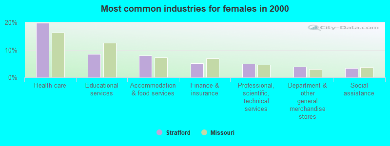
- Health care (19.9%)
- Educational services (8.5%)
- Accommodation & food services (8.0%)
- Finance & insurance (5.2%)
- Professional, scientific, technical services (4.9%)
- Department & other general merchandise stores (3.9%)
- Social assistance (3.4%)
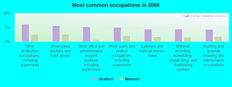
- Other production occupations, including supervisors (6.2%)
- Driver/sales workers and truck drivers (5.7%)
- Other office and administrative support workers, including supervisors (5.2%)
- Other sales and related occupations, including supervisors (5.0%)
- Laborers and material movers, hand (4.4%)
- Material recording, scheduling, dispatching, and distributing workers (4.4%)
- Building and grounds cleaning and maintenance occupations (4.3%)
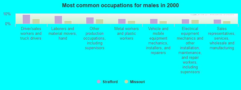
- Driver/sales workers and truck drivers (9.3%)
- Laborers and material movers, hand (8.1%)
- Other production occupations, including supervisors (6.8%)
- Metal workers and plastic workers (5.1%)
- Vehicle and mobile equipment mechanics, installers, and repairers (5.1%)
- Electrical equipment mechanics and other installation, maintenance, and repair workers, including supervisors (4.9%)
- Sales representatives, services, wholesale and manufacturing (4.4%)
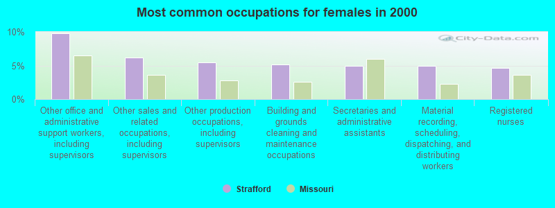
- Other office and administrative support workers, including supervisors (9.8%)
- Other sales and related occupations, including supervisors (6.2%)
- Other production occupations, including supervisors (5.4%)
- Building and grounds cleaning and maintenance occupations (5.2%)
- Secretaries and administrative assistants (4.9%)
- Material recording, scheduling, dispatching, and distributing workers (4.9%)
- Registered nurses (4.7%)
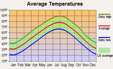
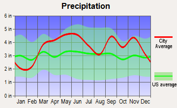
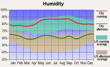
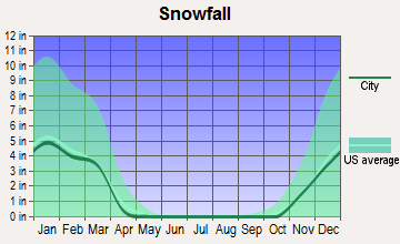
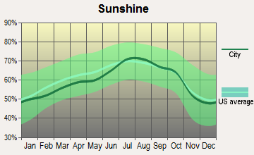
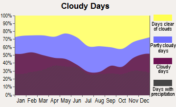
Average climate in Strafford, Missouri
Based on data reported by over 4,000 weather stations

|
|


(lower is better)
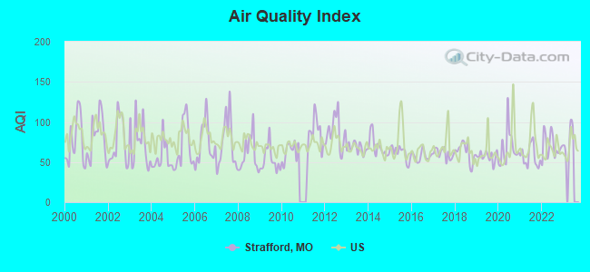
Air Quality Index (AQI) level in 2022 was 70.1. This is about average.
| City: | 70.1 |
| U.S.: | 72.6 |
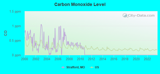
Carbon Monoxide (CO) [ppm] level in 2010 was 0.246. This is about average. Closest monitor was 9.4 miles away from the city center.
| City: | 0.246 |
| U.S.: | 0.251 |
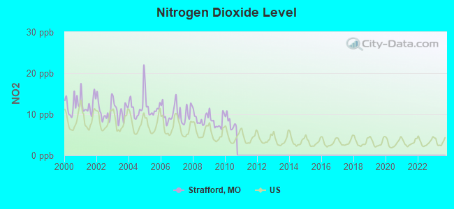
Nitrogen Dioxide (NO2) [ppb] level in 2010 was 7.97. This is significantly worse than average. Closest monitor was 7.9 miles away from the city center.
| City: | 7.97 |
| U.S.: | 5.11 |
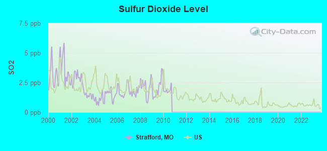
Sulfur Dioxide (SO2) [ppb] level in 2010 was 1.84. This is worse than average. Closest monitor was 7.6 miles away from the city center.
| City: | 1.84 |
| U.S.: | 1.51 |
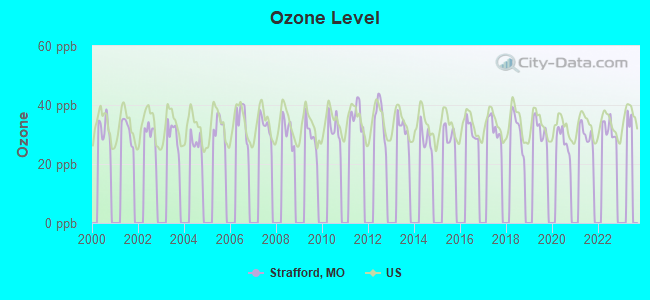
Ozone [ppb] level in 2022 was 31.8. This is about average. Closest monitor was 7.9 miles away from the city center.
| City: | 31.8 |
| U.S.: | 33.3 |
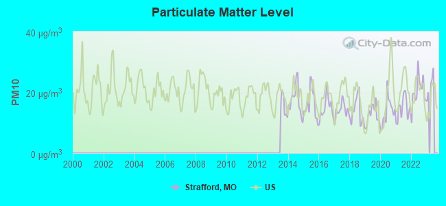
Particulate Matter (PM10) [µg/m3] level in 2022 was 20.4. This is about average. Closest monitor was 9.8 miles away from the city center.
| City: | 20.4 |
| U.S.: | 19.2 |
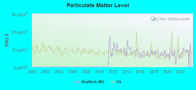
Particulate Matter (PM2.5) [µg/m3] level in 2022 was 8.38. This is about average. Closest monitor was 9.8 miles away from the city center.
| City: | 8.38 |
| U.S.: | 8.11 |
Tornado activity:
Strafford-area historical tornado activity is slightly below Missouri state average. It is 36% greater than the overall U.S. average.
On 11/29/1991, a category F4 (max. wind speeds 207-260 mph) tornado 7.2 miles away from the Strafford city center killed 2 people and injured 64 people and caused between $5,000,000 and $50,000,000 in damages.
On 9/26/1959, a category F4 tornado 25.5 miles away from the city center caused between $50,000 and $500,000 in damages.
Earthquake activity:
Strafford-area historical earthquake activity is significantly above Missouri state average. It is 542% greater than the overall U.S. average.On 9/3/2016 at 12:02:44, a magnitude 5.8 (5.8 MW, Depth: 3.5 mi, Class: Moderate, Intensity: VI - VII) earthquake occurred 218.7 miles away from Strafford center
On 11/6/2011 at 03:53:10, a magnitude 5.7 (5.7 MW, Depth: 3.2 mi) earthquake occurred 235.7 miles away from Strafford center
On 5/4/1991 at 01:18:54, a magnitude 5.0 (4.4 MB, 4.6 LG, 5.0 LG, Depth: 3.1 mi) earthquake occurred 188.8 miles away from the city center
On 3/25/1976 at 00:41:20, a magnitude 5.0 (4.9 MB, 5.0 LG) earthquake occurred 192.2 miles away from the city center
On 9/26/1990 at 13:18:51, a magnitude 5.0 (4.7 MB, 4.8 LG, 5.0 LG, Depth: 7.7 mi) earthquake occurred 197.7 miles away from Strafford center
On 2/28/2011 at 05:00:50, a magnitude 4.7 (4.7 MW, Depth: 2.0 mi, Class: Light, Intensity: IV - V) earthquake occurred 144.9 miles away from the city center
Magnitude types: regional Lg-wave magnitude (LG), body-wave magnitude (MB), moment magnitude (MW)
Natural disasters:
The number of natural disasters in Greene County (23) is greater than the US average (15).Major Disasters (Presidential) Declared: 14
Emergencies Declared: 6
Causes of natural disasters: Floods: 15, Storms: 14, Tornadoes: 8, Winter Storms: 6, Winds: 3, Drought: 1, Hurricane: 1, Other: 1 (Note: some incidents may be assigned to more than one category).

Hospitals and medical centers in Strafford:
Other hospitals and medical centers near Strafford:
- INTEGRITY HOME CARE (Home Health Center, about 6 miles away; SPRINGFIELD, MO)
- REGIONAL HOSPICE (Hospital, about 9 miles away; SPRINGFIELD, MO)
- DOCTOR'S HOSPITAL OF SPRINGFIELD INC (Hospital, about 9 miles away; SPRINGFIELD, MO)
- OZARKS COMMUNITY HOSPITAL Acute Care Hospitals (about 9 miles away; SPRINGFIELD, MO)
- CHRISTIAN HEALTH AND REHAB OF SPRINGFIELD EAST (Nursing Home, about 9 miles away; SPRINGFIELD, MO)
- HOSPICE AND PALLIATIVE CARE OF SPRINGFIELD LLC (Hospital, about 10 miles away; SPRINGFIELD, MO)
- MARANATHA VILLAGE, INC (Nursing Home, about 10 miles away; SPRINGFIELD, MO)
Airports located in Strafford:
- Cuinche Airport (MO01) (Runways: 1)
Colleges/universities with over 2000 students nearest to Strafford:
- Evangel University (about 9 miles; Springfield, MO; Full-time enrollment: 2,036)
- Ozarks Technical Community College (about 10 miles; Springfield, MO; FT enrollment: 10,356)
- Drury University (about 10 miles; Springfield, MO; FT enrollment: 3,902)
- Missouri State University-Springfield (about 10 miles; Springfield, MO; FT enrollment: 16,660)
- Southwest Baptist University (about 28 miles; Bolivar, MO; FT enrollment: 2,783)
- Missouri Southern State University (about 75 miles; Joplin, MO; FT enrollment: 4,456)
- Crowder College (about 76 miles; Neosho, MO; FT enrollment: 3,675)
Public high school in Strafford:
- STRAFFORD HIGH (Students: 340, Location: 201 W MCCABE, Grades: 9-12)
Public elementary/middle schools in Strafford:
- STRAFFORD ELEM. (Students: 477, Location: 213 W MCCABE, Grades: PK-4)
- STRAFFORD MIDDLE (Students: 380, Location: 211 W MCCABE, Grades: 5-8)
User-submitted facts and corrections:
- The official Web site of Strafford, MO is http://www.straffordmo.org
Points of interest:
Notable locations in Strafford: Strafford Fire Protection District Station 1 (A), Strafford Fire Protection District Station 3 (B). Display/hide their locations on the map
Cemetery: Mullinax Cemetery (1). Display/hide its location on the map
Drinking water stations with addresses in Strafford and their reported violations in the past:
WILD ANIMAL SAFARI INC (Population served: 325, Groundwater):Past health violations:STRAFFORD SPORTS COMPLEX (Population served: 250, Groundwater):Past monitoring violations:
- MCL, Monthly (TCR) - In JUN-2010, Contaminant: Coliform. Follow-up actions: St Violation/Reminder Notice (JUL-15-2010), St Public Notif requested (JUL-15-2010), St Compliance achieved (MAY-04-2011), St BCA signed (OCT-10-2011), St Formal NOV issued (OCT-20-2011), St Public Notif received (OCT-27-2011), St Public Notif issued (AUG-21-2012), St Compliance achieved (2 times from APR-09-2014 to APR-09-2014)
- MCL, Monthly (TCR) - In FEB-2010, Contaminant: Coliform. Follow-up actions: St Violation/Reminder Notice (APR-01-2010), St Public Notif requested (APR-01-2010), St Compliance achieved (SEP-30-2010), St BCA signed (OCT-10-2011), St Formal NOV issued (OCT-20-2011), St Public Notif received (OCT-27-2011), St Public Notif issued (AUG-21-2012), St Compliance achieved (2 times from APR-09-2014 to APR-09-2014)
- MCL, Monthly (TCR) - In JAN-2010, Contaminant: Coliform. Follow-up actions: St Violation/Reminder Notice (MAR-01-2010), St Public Notif requested (MAR-01-2010), St Compliance achieved (SEP-30-2010), St BCA signed (OCT-10-2011), St Formal NOV issued (OCT-20-2011), St Public Notif received (OCT-27-2011), St Public Notif issued (AUG-21-2012), St Compliance achieved (2 times from APR-09-2014 to APR-09-2014)
- 11 routine major monitoring violations
- One minor monitoring violation
Past monitoring violations:FOUNTAIN PLAZA MHP (Population served: 165, Groundwater):
- 12 routine major monitoring violations
- One minor monitoring violation
- 2 regular monitoring violations
Past monitoring violations:ACRES OF SHADE MHP (Population served: 109, Groundwater):
- Follow-up Or Routine LCR Tap M/R - In OCT-01-2013, Contaminant: Lead and Copper Rule. Follow-up actions: St Formal NOV issued (NOV-19-2013), St Public Notif requested (NOV-19-2013)
- One regular monitoring violation
Past monitoring violations:PARADISE IN THE WOODS RV PARK (Population served: 50, Groundwater):
- Lead Consumer Notice - In JAN-01-2011, Contaminant: Lead and Copper Rule. Follow-up actions: St Compliance achieved (JUN-03-2014)
- 4 routine major monitoring violations
- One minor monitoring violation
- 33 regular monitoring violations
Past health violations:FAIR HAVEN CHILDRENS HOME (Population served: 45, Groundwater):Past monitoring violations:
- MCL, Monthly (TCR) - In SEP-2012, Contaminant: Coliform. Follow-up actions: St Public Notif requested (SEP-26-2012), St Formal NOV issued (SEP-26-2012), St Public Notif received (OCT-15-2012), St Compliance achieved (JAN-22-2014)
- 5 routine major monitoring violations
Past monitoring violations:
- 2 routine major monitoring violations
| This city: | 2.6 people |
| Missouri: | 2.5 people |
| This city: | 73.4% |
| Whole state: | 65.3% |
| This city: | 6.3% |
| Whole state: | 6.7% |
Likely homosexual households (counted as self-reported same-sex unmarried-partner households)
- Lesbian couples: 0.1% of all households
- Gay men: 0.3% of all households
56 people in nursing homes in 2000
Banks with branches in Strafford (2011 data):
- O'Bannon Banking Company: Strafford Branch at 201 S. State Hwy 125, branch established on 2002/12/16. Info updated 2006/11/03: Bank assets: $148.2 mil, Deposits: $130.8 mil, headquarters in Buffalo, MO, positive income, Agricultural Specialization, 5 total offices, Holding Company: Buffalo Bancshares, Inc.
- Empire Bank: Strafford Branch at 213 East Route 66, branch established on 1993/02/01. Info updated 2010/10/18: Bank assets: $1,024.1 mil, Deposits: $867.6 mil, headquarters in Springfield, MO, positive income, Commercial Lending Specialization, 23 total offices, Holding Company: Central Bancompany
For population 15 years and over in Strafford:
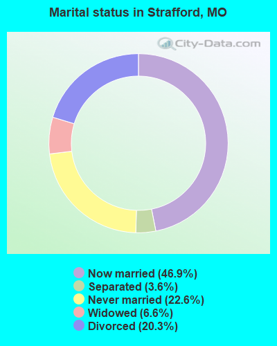
- Never married: 22.6%
- Now married: 46.9%
- Separated: 3.6%
- Widowed: 6.6%
- Divorced: 20.3%
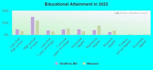
For population 25 years and over in Strafford:
- High school or higher: 87.8%
- Bachelor's degree or higher: 17.3%
- Graduate or professional degree: 7.2%
- Unemployed: 3.6%
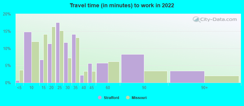
- Mean travel time to work (commute): 17.8 minutes
| Here: | 9.2 |
| Missouri average: | 11.1 |
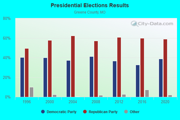
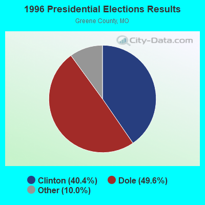
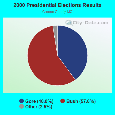

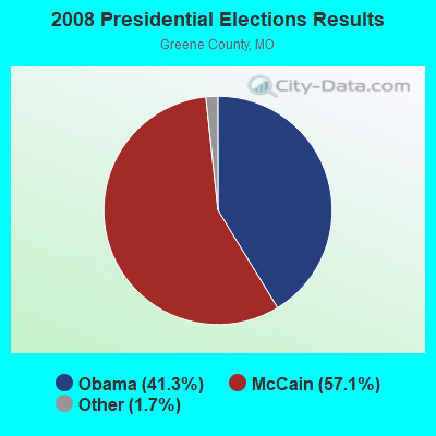
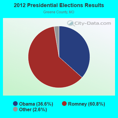


Graphs represent county-level data. Detailed 2008 Election Results
Religion statistics for Strafford, MO (based on Greene County data)
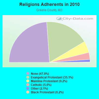
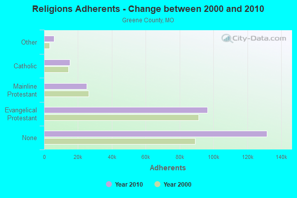
| Religion | Adherents | Congregations |
|---|---|---|
| Evangelical Protestant | 96,521 | 258 |
| Mainline Protestant | 25,250 | 59 |
| Catholic | 15,294 | 6 |
| Other | 5,731 | 26 |
| Black Protestant | 624 | 4 |
| Orthodox | 121 | 2 |
| None | 131,633 | - |
Food Environment Statistics:
| Greene County: | 1.33 / 10,000 pop. |
| Missouri: | 1.88 / 10,000 pop. |
| Here: | 0.23 / 10,000 pop. |
| State: | 0.18 / 10,000 pop. |
| This county: | 0.15 / 10,000 pop. |
| State: | 0.60 / 10,000 pop. |
| Greene County: | 3.60 / 10,000 pop. |
| State: | 4.34 / 10,000 pop. |
| Here: | 8.11 / 10,000 pop. |
| Missouri: | 7.37 / 10,000 pop. |
| Here: | 8.0% |
| State: | 8.8% |
| Here: | 29.1% |
| Missouri: | 29.6% |
| Here: | 12.3% |
| Missouri: | 13.5% |
Health and Nutrition:
| Strafford: | 48.9% |
| Missouri: | 50.9% |
| This city: | 47.4% |
| Missouri: | 48.6% |
| Strafford: | 29.0 |
| Missouri: | 28.7 |
| Strafford: | 22.2% |
| Missouri: | 20.6% |
| Strafford: | 9.8% |
| Missouri: | 10.1% |
| Strafford: | 6.8 |
| Missouri: | 6.8 |
| Here: | 37.0% |
| State: | 34.3% |
| Here: | 57.1% |
| Missouri: | 57.5% |
| Strafford: | 79.5% |
| Missouri: | 79.3% |
More about Health and Nutrition of Strafford, MO Residents
| Local government employment and payroll (March 2022) | |||||
| Function | Full-time employees | Monthly full-time payroll | Average yearly full-time wage | Part-time employees | Monthly part-time payroll |
|---|---|---|---|---|---|
| Police Protection - Officers | 5 | $19,971 | $47,930 | 1 | $272 |
| Other Government Administration | 2 | $10,067 | $60,402 | 7 | $1,771 |
| Judicial and Legal | 1 | $3,004 | $36,048 | 0 | $0 |
| Financial Administration | 0 | $0 | 1 | $784 | |
| Totals for Government | 8 | $33,042 | $49,563 | 9 | $2,828 |
Strafford government finances - Expenditure in 2017 (per resident):
- Current Operations - Sewerage: $528,000 ($199.77)
Police Protection: $497,000 ($188.04)
Water Utilities: $238,000 ($90.05)
Central Staff Services: $111,000 ($42.00)
Regular Highways: $109,000 ($41.24)
Judicial and Legal Services: $100,000 ($37.84)
General - Other: $100,000 ($37.84)
Solid Waste Management: $98,000 ($37.08)
Parks and Recreation: $69,000 ($26.11)
Protective Inspection and Regulation - Other: $37,000 ($14.00)
Health - Other: $5,000 ($1.89)
- General - Interest on Debt: $18,000 ($6.81)
- Other Capital Outlay - Parks and Recreation: $381,000 ($144.15)
General - Other: $121,000 ($45.78)
- Total Salaries and Wages: $620,000 ($234.58)
Strafford government finances - Revenue in 2017 (per resident):
- Charges - Sewerage: $614,000 ($232.31)
Solid Waste Management: $113,000 ($42.75)
- Local Intergovernmental - Other: $45,000 ($17.03)
Highways: $15,000 ($5.68)
- Miscellaneous - Fines and Forfeits: $144,000 ($54.48)
Interest Earnings: $25,000 ($9.46)
General Revenue - Other: $21,000 ($7.95)
Rents: $4,000 ($1.51)
- Revenue - Water Utilities: $295,000 ($111.62)
- State Intergovernmental - Highways: $70,000 ($26.49)
Other: $14,000 ($5.30)
- Tax - General Sales and Gross Receipts: $791,000 ($299.28)
Public Utilities Sales: $147,000 ($55.62)
Property: $99,000 ($37.46)
Other License: $22,000 ($8.32)
Strafford government finances - Cash and Securities in 2017 (per resident):
- Bond Funds - Cash and Securities: $47,000 ($17.78)
- Other Funds - Cash and Securities: $1,330,000 ($503.22)
| Businesses in Strafford, MO | ||||
| Name | Count | Name | Count | |
|---|---|---|---|---|
| FedEx | 3 | Super 8 | 1 | |
| McDonald's | 1 | UPS | 1 | |
| Subway | 1 | |||
Strongest AM radio stations in Strafford:
- KMRF (1510 AM; daytime; 5 kW; MARSHFIELD, MO; Owner: NEW LIFE EVANGELISTIC CENTER, INC.)
- KSGF (1260 AM; 5 kW; SPRINGFIELD, MO; Owner: JOURNAL BROADCAST CORPORATION)
- KLFJ (1550 AM; 5 kW; SPRINGFIELD, MO; Owner: 127, INC.)
- KWTO (560 AM; 5 kW; SPRINGFIELD, MO; Owner: KWTO, INC.)
- KGMY (1400 AM; 1 kW; SPRINGFIELD, MO; Owner: CLEAR CHANNEL BROADCASTING LICENSES, INC.)
- KBNN (750 AM; daytime; 5 kW; LEBANON, MO; Owner: OZARK BROADCASTING, INC.)
- KIDS (1340 AM; 1 kW; SPRINGFIELD, MO; Owner: THIRTEEN FORTY PRODUCTIONS INC.)
- KTOZ (1060 AM; daytime; 0 kW; SPRINGFIELD, MO; Owner: THE ENTERTAINMENT NETWORK, INC.)
- WHB (810 AM; 50 kW; KANSAS CITY, MO; Owner: UNION BROADCASTING, INC.)
- KRMS (1150 AM; 10 kW; OSAGE BEACH, MO; Owner: VIPER COMMUNICATIONS, INC)
- KRMG (740 AM; 50 kW; TULSA, OK; Owner: CXR HOLDINGS, INC.)
- KGHT (880 AM; 50 kW; SHERIDAN, AR; Owner: METROPOLITAN RADIO GROUP, INC.)
- KKOW (860 AM; 10 kW; PITTSBURG, KS; Owner: AMERICAN MEDIA INVESTMENTS)
Strongest FM radio stations in Strafford:
- KSCV (90.1 FM; SPRINGFIELD, MO; Owner: COMMUNITY BROADCASTING, INC.)
- KTTS-FM (94.7 FM; SPRINGFIELD, MO; Owner: JOURNAL BROADCAST CORPORATION)
- KXUS (97.3 FM; SPRINGFIELD, MO; Owner: CLEAR CHANNEL BROADCASTING LICENSES, INC.)
- KTXR (101.3 FM; SPRINGFIELD, MO; Owner: STEREO BROADCASTING, INC.)
- KWFC (89.1 FM; SPRINGFIELD, MO; Owner: BAPTIST BIBLE COLLEGE, INC.)
- KWND (88.3 FM; SPRINGFIELD, MO; Owner: RADIO TRAINING NETWORK, INC)
- KKLH (104.7 FM; MARSHFIELD, MO; Owner: MW SPRINGMO, INC.)
- KGBX-FM (105.9 FM; NIXA, MO; Owner: CLEAR CHANNEL BROADCASTING LICENSES, INC.)
- KTOZ-FM (95.5 FM; PLEASANT HOPE, MO; Owner: CLEAR CHANNEL BROADCASTING LICENSES, INC.)
- KSPW (96.5 FM; SPARTA, MO; Owner: JOURNAL BROADCAST CORPORATION)
- KSMU (91.1 FM; SPRINGFIELD, MO; Owner: BD OF REGENTS FOR SW MO ST UNIV)
- KNLM (91.9 FM; MARSHFIELD, MO; Owner: NEW LIFE EVANGELISTIC CENTER, INC.)
- KWTO-FM (98.7 FM; SPRINGFIELD, MO; Owner: KWTO, INC.)
- KJEL (103.7 FM; LEBANON, MO; Owner: OZARK BROADCASTING, INC.)
- KBFL (99.9 FM; BUFFALO, MO; Owner: MEYER-BALDRIDGE, INC.)
- KGMY-FM (100.5 FM; AURORA, MO; Owner: CLEAR CHANNEL BROADCASTING LICENSES, INC.)
- KADI (99.5 FM; REPUBLIC, MO; Owner: VISION COMMUNICATIONS, INCORPORATED)
- KOSP (105.1 FM; WILLARD, MO; Owner: MW SPRINGMO, INC.)
- KOMG (92.9 FM; OZARK, MO; Owner: MW SPRINGMO, INC.)
- KZRQ (104.1 FM; ASH GROVE, MO; Owner: CITADEL BROADCASTING COMPANY)
TV broadcast stations around Strafford:
- KYTV (Channel 3; SPRINGFIELD, MO; Owner: KY3, INC.)
- KSPR (Channel 33; SPRINGFIELD, MO; Owner: PIEDMONT TELEVISION OF SPRINGFIELD LICENSE LLC)
- KOLR (Channel 10; SPRINGFIELD, MO; Owner: VHR SPRINGFIELD LICENSE, INC.)
- KDEB-TV (Channel 27; SPRINGFIELD, MO; Owner: QUORUM OF MISSOURI LICENSE, LLC)
- KOZK (Channel 21; SPRINGFIELD, MO; Owner: BD. OF GOVERNORS OF SW MISSOURI STATE UNIVERSITY)
- K68EL (Channel 68; MARSHFIELD, MO; Owner: NEW LIFE EVANGELISTIC CENTER, INC.)
- KWBS-LP (Channel 56; SPRINGFIELD, MO; Owner: EQUITY BROADCASTING CORPORATION)
- K15CZ (Channel 15; SPRINGFIELD, MO; Owner: KY3, INC.)
- K41FQ (Channel 41; SPRINGFIELD, MO; Owner: TRINITY BROADCASTING NETWORK)
- K08MA (Channel 8; SPRINGFIELD, MO; Owner: METROPOLITAN RADIO GROUP, INC.)
- K49DG (Channel 49; SPRINGFIELD, MO; Owner: TRINITY BROADCASTING NETWORK)
- K54FX (Channel 54; SPRINGFIELD, MO; Owner: NEW LIFE EVANGELISTIC CENTER, INC.)
- KWBM (Channel 31; HARRISON, AR; Owner: R.S. COMMUNICATIONS LTD. PARTNERSHIP)
- Strafford, Missouri
- Fatal accident count20
- Vehicles involved in fatal accidents35
- Fatal accidents involving drunk persons:3
- Fatalities21
- Persons involved in fatal accidents54
- Pedestrians involved in fatal accidents7
- Missouri average
- Fatal accident count16061
- Vehicles involved in fatal accidents24311
- Fatal accidents involving drunk persons5120
- Fatalities17991
- Persons involved in fatal accidents40214
- Pedestrians involved in fatal accidents1411
- National Bridge Inventory (NBI) Statistics
- 13Number of bridges
- 66ft / 20.4mTotal length
- $395,000Total costs
- 49,292Total average daily traffic
- 15,283Total average daily truck traffic
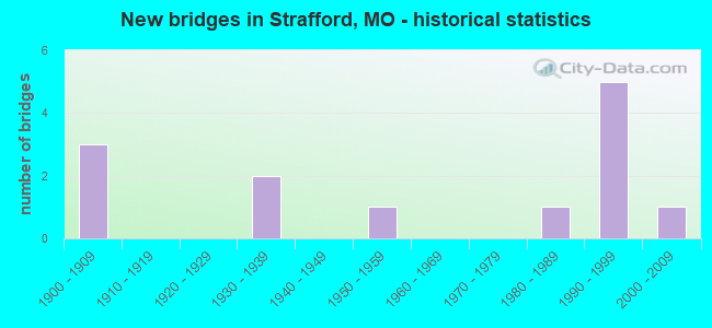
- New bridges - historical statistics
- 31900-1909
- 21930-1939
- 11950-1959
- 11980-1989
- 51990-1999
- 12000-2009
FCC Registered Broadcast Land Mobile Towers: 16 (See the full list of FCC Registered Broadcast Land Mobile Towers in Strafford, MO)
FCC Registered Microwave Towers: 11 (See the full list of FCC Registered Microwave Towers in this town)
FCC Registered Amateur Radio Licenses: 64 (See the full list of FCC Registered Amateur Radio Licenses in Strafford)
FAA Registered Aircraft: 8 (See the full list of FAA Registered Aircraft in Strafford)
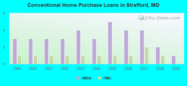
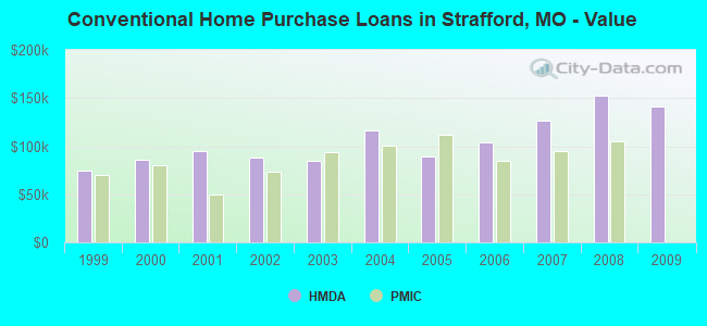
| Home Mortgage Disclosure Act Aggregated Statistics For Year 2009 (Based on 1 partial tract) | ||||||
| A) FHA, FSA/RHS & VA Home Purchase Loans | B) Conventional Home Purchase Loans | C) Refinancings | ||||
|---|---|---|---|---|---|---|
| Number | Average Value | Number | Average Value | Number | Average Value | |
| LOANS ORIGINATED | 1 | $123,410 | 1 | $141,130 | 6 | $144,875 |
| APPLICATIONS APPROVED, NOT ACCEPTED | 0 | $0 | 0 | $0 | 1 | $77,380 |
| APPLICATIONS DENIED | 0 | $0 | 0 | $0 | 2 | $157,630 |
| APPLICATIONS WITHDRAWN | 0 | $0 | 0 | $0 | 2 | $118,115 |
| FILES CLOSED FOR INCOMPLETENESS | 0 | $0 | 0 | $0 | 0 | $0 |
Detailed HMDA statistics for the following Tracts: 0046.00
| Private Mortgage Insurance Companies Aggregated Statistics For Year 2008 (Based on 1 partial tract) | ||
| A) Conventional Home Purchase Loans | ||
|---|---|---|
| Number | Average Value | |
| LOANS ORIGINATED | 1 | $104,960 |
| APPLICATIONS APPROVED, NOT ACCEPTED | 0 | $0 |
| APPLICATIONS DENIED | 0 | $0 |
| APPLICATIONS WITHDRAWN | 0 | $0 |
| FILES CLOSED FOR INCOMPLETENESS | 0 | $0 |
Detailed PMIC statistics for the following Tracts: 0046.00
2002 - 2018 National Fire Incident Reporting System (NFIRS) incidents
- Fire incident types reported to NFIRS in Strafford, MO
- 55348.1%Outside Fires
- 44638.8%Structure Fires
- 12811.1%Mobile Property/Vehicle Fires
- 232.0%Other
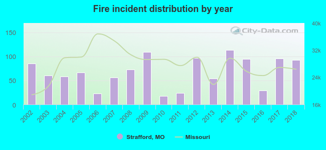 According to the data from the years 2002 - 2018 the average number of fires per year is 68. The highest number of reported fires - 113 took place in 2014, and the least - 18 in 2010. The data has a rising trend.
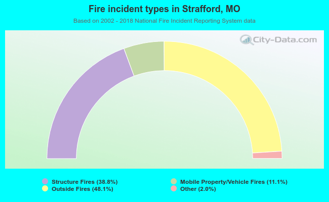 When looking into fire subcategories, the most reports belonged to: Outside Fires (48.1%), and Structure Fires (38.8%).
| Most common first names in Strafford, MO among deceased individuals | ||
| Name | Count | Lived (average) |
|---|---|---|
| James | 29 | 73.7 years |
| William | 28 | 75.3 years |
| Mary | 22 | 80.4 years |
| John | 18 | 79.1 years |
| Charles | 17 | 72.8 years |
| Robert | 15 | 73.7 years |
| George | 14 | 80.5 years |
| Frank | 14 | 77.1 years |
| Helen | 11 | 71.8 years |
| Kenneth | 10 | 70.2 years |
| Most common last names in Strafford, MO among deceased individuals | ||
| Last name | Count | Lived (average) |
|---|---|---|
| Smith | 13 | 77.1 years |
| Campbell | 12 | 75.8 years |
| Dishman | 12 | 77.1 years |
| Davis | 10 | 81.1 years |
| Potter | 10 | 80.4 years |
| Reed | 8 | 75.0 years |
| Anderson | 8 | 82.6 years |
| Comstock | 8 | 78.9 years |
| Bumgarner | 8 | 78.9 years |
| Williams | 7 | 72.4 years |
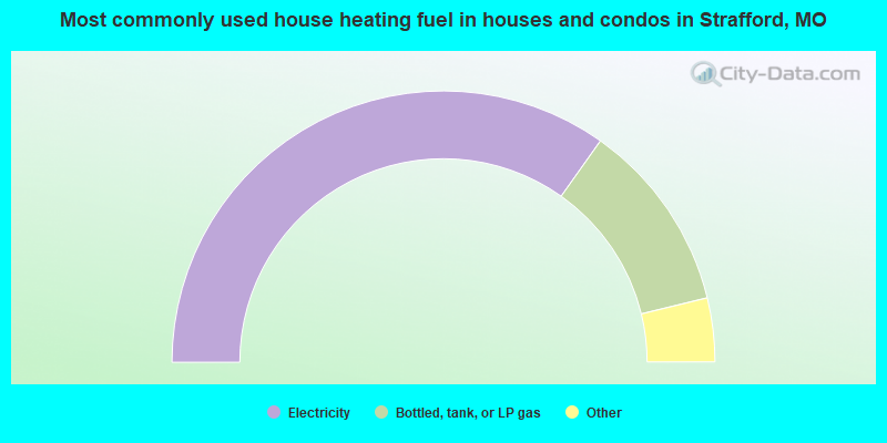
- 69.7%Electricity
- 22.8%Bottled, tank, or LP gas
- 3.5%Wood
- 2.0%Utility gas
- 2.0%Other fuel
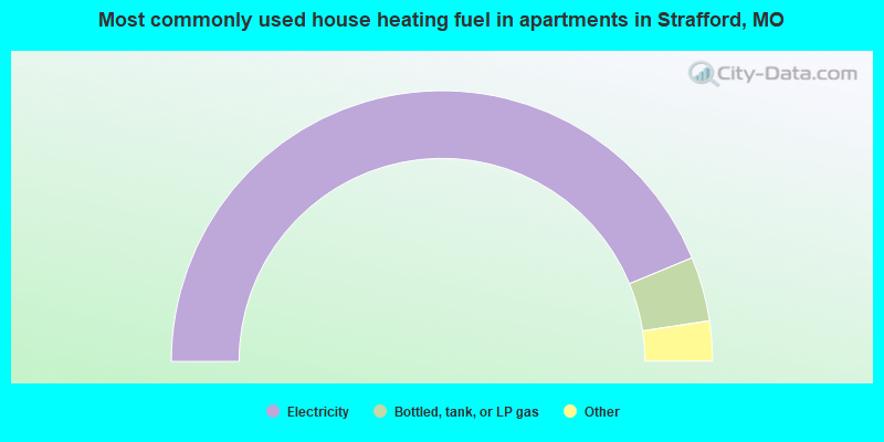
- 87.7%Electricity
- 7.7%Bottled, tank, or LP gas
- 3.1%Utility gas
- 1.5%Wood
Strafford compared to Missouri state average:
- Unemployed percentage significantly below state average.
- Black race population percentage significantly below state average.
- Foreign-born population percentage significantly below state average.
- Length of stay since moving in significantly above state average.
- House age below state average.

|
|
Total of 21 patent applications in 2008-2024.