Thorn Hill, Tennessee
Submit your own pictures of this place and show them to the world
- OSM Map
- General Map
- Google Map
- MSN Map

| Males: 693 | |
| Females: 684 |
| Median resident age: | 37.7 years |
| Tennessee median age: | 35.9 years |
Zip code: 37881
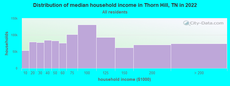
| Thorn Hill: | $43,251 |
| TN: | $65,254 |
Estimated per capita income in 2022: $21,020 (it was $11,278 in 2000)
Thorn Hill CCD income, earnings, and wages data
Estimated median house or condo value in 2022: $156,791 (it was $55,100 in 2000)
| Thorn Hill: | $156,791 |
| TN: | $284,800 |
Mean prices in 2022: all housing units: $241,672; detached houses: $298,546; townhouses or other attached units: $172,174; mobile homes: $84,814; occupied boats, rvs, vans, etc.: $54,184
Detailed information about poverty and poor residents in Thorn Hill, TN
Compare current foreclosures near Thorn Hill, TN:
| Photo | Address | Area | Beds / Baths | Price | Details |
|---|---|---|---|---|---|

|
#1
Thorn Hill School Rd
Thorn Hill, TN 37881
|
1,736 sq. feet
|
2 baths - beds |
show details | |

|
#2
C W Ln
Thorn Hill, TN 37881
|
- sq. feet
|
- baths - beds |
show details | |

|
#3
Union Church Rd
Thorn Hill, TN 37881
|
- sq. feet
|
- baths - beds |
show details | |

|
#4
Highway 131
Washburn, TN 37888
|
1,400 sq. feet
|
2 baths 3 beds |
$280,000
|
show details |

|
#5
Rosedale Ave
Morristown, TN 37813
|
792 sq. feet
|
1 baths 2 beds |
$165,000
|
show details |

|
#6
Bullen Valley Rd
Thorn Hill, TN 37881
|
- sq. feet
|
- baths - beds |
show details | |

|
#7
W 6th North St
Morristown, TN 37814
|
2,112 sq. feet
|
2 baths 3 beds |
show details | |

|
#8
Adams Ln
Tazewell, TN 37879
|
1,344 sq. feet
|
1 baths 3 beds |
show details | |

|
#9
Collins St
Sneedville, TN 37869
|
1,223 sq. feet
|
2 baths 3 beds |
show details | |

|
#10
Cherrybrook Ln
Talbott, TN 37877
|
1,400 sq. feet
|
2 baths 3 beds |
show details |
| Photo | Address | Area | Beds / Baths | Price | Details |
|---|---|---|---|---|---|

|
#11
Le Conte St
Morristown, TN 37814
|
2,049 sq. feet
|
2 baths 2 beds |
show details | |

|
#12
Browning Way
Russellville, TN 37860
|
1,300 sq. feet
|
2 baths - beds |
show details | |

|
#13
Blair St
Morristown, TN 37814
|
672 sq. feet
|
1 baths - beds |
show details | |

|
#14
Milburn St
Morristown, TN 37814
|
999 sq. feet
|
1 baths - beds |
show details | |

|
#15
Blackberry Ln
Morristown, TN 37814
|
1,624 sq. feet
|
2 baths - beds |
show details | |

|
#16
Spring Hollow Dr
Morristown, TN 37814
|
1,680 sq. feet
|
2 baths - beds |
show details | |

|
#17
E 2nd North St
Morristown, TN 37814
|
1,275 sq. feet
|
1 baths - beds |
show details | |

|
#18
Jaybird Rd
Morristown, TN 37814
|
1,096 sq. feet
|
1 baths - beds |
show details | |

|
#19
Bullard Dr
Morristown, TN 37814
|
1,568 sq. feet
|
2 baths - beds |
show details | |

|
#20
Pine Barren Dr
Morristown, TN 37814
|
2,294 sq. feet
|
2 baths - beds |
show details |
| Photo | Address | Area | Beds / Baths | Price | Details |
|---|---|---|---|---|---|

|
#21
Pinewood Cir
Morristown, TN 37814
|
2,052 sq. feet
|
2 baths - beds |
show details | |

|
#22
Cline Ave
Morristown, TN 37814
|
1,886 sq. feet
|
2 baths - beds |
show details | |

|
#23
Southern Dr
Morristown, TN 37814
|
1,728 sq. feet
|
1 baths - beds |
show details | |

|
#24
Seven Oaks Dr
Morristown, TN 37814
|
2,340 sq. feet
|
2 baths - beds |
show details | |

|
#25
Fairfax Cir
Morristown, TN 37814
|
2,023 sq. feet
|
1 baths - beds |
show details | |

|
#26
Crown Cir
Morristown, TN 37814
|
1,343 sq. feet
|
1 baths - beds |
show details | |

|
#27
Highway 131
Washburn, TN 37888
|
1,248 sq. feet
|
2 baths - beds |
show details | |

|
#28
Musick Rd
Morristown, TN 37814
|
986 sq. feet
|
1 baths - beds |
show details | |

|
#29
Horseshoe Trl
Morristown, TN 37814
|
2,536 sq. feet
|
3 baths - beds |
show details | |

|
#30
Carriger St
Morristown, TN 37814
|
750 sq. feet
|
1 baths - beds |
show details |
| Photo | Address | Area | Beds / Baths | Price | Details |
|---|---|---|---|---|---|

|
#31
Opal St
Tazewell, TN 37879
|
936 sq. feet
|
1 baths - beds |
show details | |

|
#32
N Henry St
Morristown, TN 37814
|
1,080 sq. feet
|
2 baths - beds |
show details | |

|
#33
Hamilton Pl
Morristown, TN 37814
|
1,956 sq. feet
|
2 baths - beds |
show details | |

|
#34
Collinson Ford Rd
Morristown, TN 37814
|
2,592 sq. feet
|
2 baths - beds |
show details | |

|
#35
Reese St
Morristown, TN 37814
|
2,064 sq. feet
|
2 baths - beds |
show details | |

|
#36
Camilla Ave
Morristown, TN 37814
|
1,767 sq. feet
|
2 baths - beds |
show details | |

|
#37
Ash St
Morristown, TN 37813
|
1,168 sq. feet
|
2 baths - beds |
show details | |

|
#38
Lakeshore Dr
Rutledge, TN 37861
|
1,904 sq. feet
|
1 baths - beds |
show details | |

|
#39
Hunter Rd
Talbott, TN 37877
|
1,350 sq. feet
|
2 baths - beds |
show details | |

|
#40
Sublett Rd
Morristown, TN 37813
|
1,464 sq. feet
|
2 baths - beds |
show details |
| Photo | Address | Area | Beds / Baths | Price | Details |
|---|---|---|---|---|---|

|
#41
Rutledge Pike
Blaine, TN 37709
|
1,760 sq. feet
|
1 baths - beds |
show details | |

|
#42
Lonnie Cir
Morristown, TN 37813
|
1,450 sq. feet
|
2 baths - beds |
show details | |

|
#43
Beth Dr
Russellville, TN 37860
|
1,620 sq. feet
|
2 baths - beds |
show details | |

|
#44
Bethel Rd
Morristown, TN 37813
|
1,782 sq. feet
|
2 baths - beds |
show details | |

|
#45
Highway 131
Powder Springs, TN 37848
|
1,088 sq. feet
|
1 baths - beds |
show details | |

|
#46
Crestview Dr
Talbott, TN 37877
|
2,100 sq. feet
|
1 baths - beds |
show details | |

|
#47
Saint Clair Rd
Whitesburg, TN 37891
|
1,200 sq. feet
|
1 baths - beds |
show details | |

|
#48
Watson Cut Rd
New Tazewell, TN 37825
|
2,280 sq. feet
|
2 baths - beds |
show details | |

|
#49
Fish Hatchery Rd
Morristown, TN 37813
|
1,304 sq. feet
|
2 baths - beds |
show details | |

|
Check over 1 million property listings on Foreclosure.com!
|
browse all offers | |||

- 1,24398.4%White alone
- 80.6%Black alone
- 50.4%Two or more races
- 50.4%Hispanic
- 10.08%Asian alone
- 10.08%Other race alone
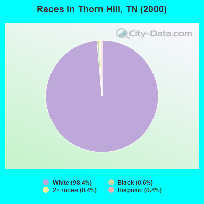
Races in Thorn Hill detailed stats: ancestries, foreign born residents, place of birth
According to our research of Tennessee and other state lists, there were 8 registered sex offenders living in Thorn Hill, Tennessee as of May 15, 2024.
The ratio of all residents to sex offenders in Thorn Hill is 172 to 1.
 Recent articles from our blog. Our writers, many of them Ph.D. graduates or candidates, create easy-to-read articles on a wide variety of topics.
Current Local Time: EST time zone
Elevation: 1400 feet
Land area: 38.4 square miles.
Population density: 36 people per square mile (very low).

| Thorn Hill CCD: | 0.6% ($318) |
| Tennessee: | 0.8% ($715) |
Nearest city with pop. 50,000+: Knoxville, TN  (40.3 miles , pop. 173,890).
Nearest city with pop. 200,000+: Fayette, KY (128.6 miles , pop. 260,512).
Nearest city with pop. 1,000,000+: Chicago, IL (441.4 miles , pop. 2,896,016).
Nearest cities:
), ), ), Latitude: 36.38 N, Longitude: 83.42 W
Area code commonly used in this area: 865

| Here: | 3.2% |
| Tennessee: | 3.0% |
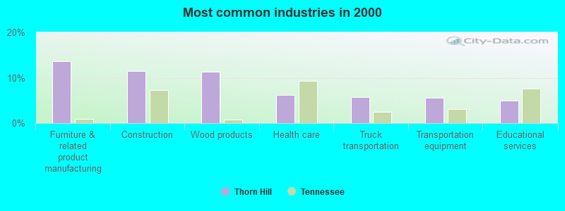
- Furniture & related product manufacturing (13.7%)
- Construction (11.5%)
- Wood products (11.3%)
- Health care (6.2%)
- Truck transportation (5.8%)
- Transportation equipment (5.6%)
- Educational services (4.9%)
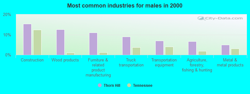
- Construction (15.3%)
- Wood products (12.6%)
- Furniture & related product manufacturing (11.0%)
- Truck transportation (9.0%)
- Transportation equipment (7.0%)
- Agriculture, forestry, fishing & hunting (6.6%)
- Metal & metal products (5.0%)
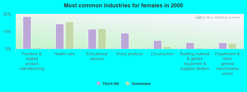
- Furniture & related product manufacturing (18.6%)
- Health care (14.4%)
- Educational services (11.4%)
- Wood products (9.0%)
- Construction (4.8%)
- Building material & garden equipment & supplies dealers (3.6%)
- Department & other general merchandise stores (3.6%)
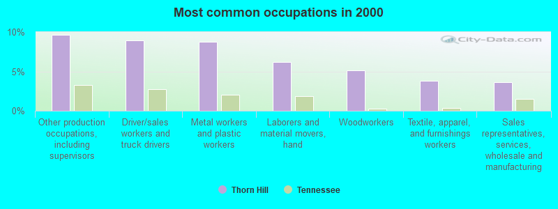
- Other production occupations, including supervisors (9.6%)
- Driver/sales workers and truck drivers (9.0%)
- Metal workers and plastic workers (8.8%)
- Laborers and material movers, hand (6.2%)
- Woodworkers (5.1%)
- Textile, apparel, and furnishings workers (3.8%)
- Sales representatives, services, wholesale and manufacturing (3.6%)
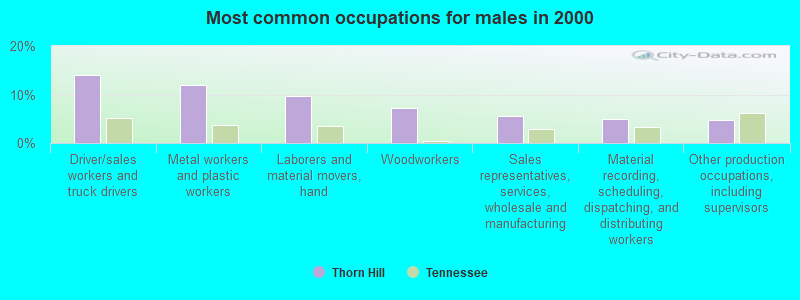
- Driver/sales workers and truck drivers (14.0%)
- Metal workers and plastic workers (12.0%)
- Laborers and material movers, hand (9.6%)
- Woodworkers (7.3%)
- Sales representatives, services, wholesale and manufacturing (5.6%)
- Material recording, scheduling, dispatching, and distributing workers (5.0%)
- Other production occupations, including supervisors (4.7%)

- Other production occupations, including supervisors (18.6%)
- Health technologists and technicians (7.8%)
- Textile, apparel, and furnishings workers (6.6%)
- Other sales and related occupations, including supervisors (6.6%)
- Preschool, kindergarten, elementary, and middle school teachers (6.0%)
- Nursing, psychiatric, and home health aides (5.4%)
- Secretaries and administrative assistants (4.8%)
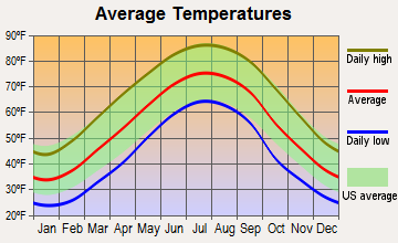
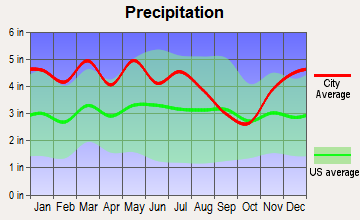
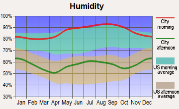
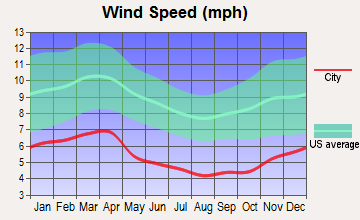
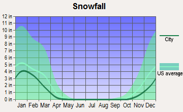
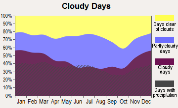
Average climate in Thorn Hill, Tennessee
Based on data reported by over 4,000 weather stations
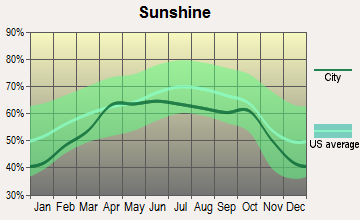
(lower is better)
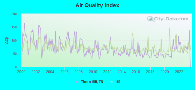
Air Quality Index (AQI) level in 2023 was 80.8. This is about average.
| City: | 80.8 |
| U.S.: | 72.6 |
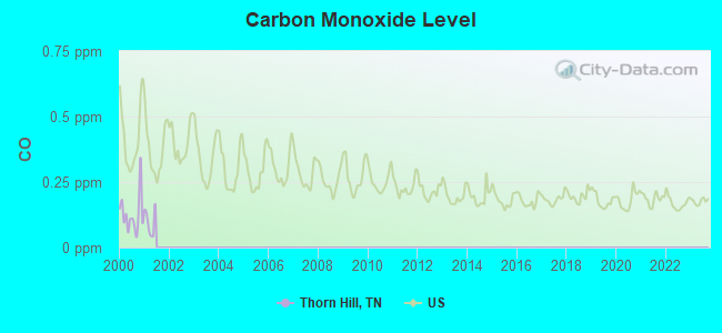
Carbon Monoxide (CO) [ppm] level in 2000 was 0.127. This is significantly better than average. Closest monitor was 22.7 miles away from the city center.
| City: | 0.127 |
| U.S.: | 0.251 |
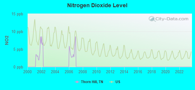
Nitrogen Dioxide (NO2) [ppb] level in 2006 was 4.41. This is about average. Closest monitor was 14.0 miles away from the city center.
| City: | 4.41 |
| U.S.: | 5.11 |
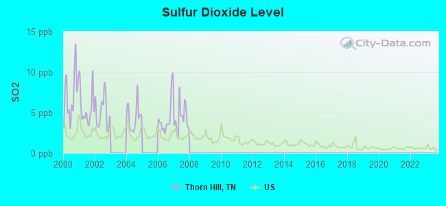
Sulfur Dioxide (SO2) [ppb] level in 2007 was 4.34. This is significantly worse than average. Closest monitor was 14.0 miles away from the city center.
| City: | 4.34 |
| U.S.: | 1.51 |
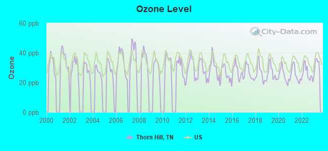
Ozone [ppb] level in 2023 was 31.3. This is about average. Closest monitor was 5.0 miles away from the city center.
| City: | 31.3 |
| U.S.: | 33.3 |
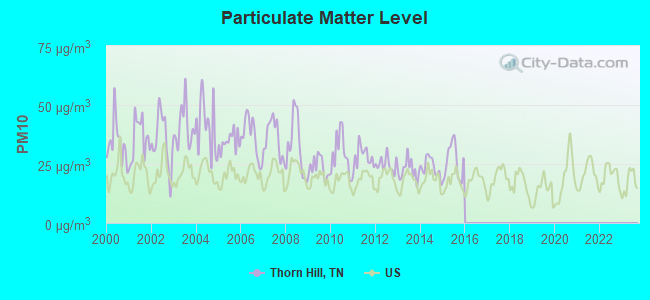
Particulate Matter (PM10) [µg/m3] level in 2015 was 26.0. This is worse than average. Closest monitor was 16.8 miles away from the city center.
| City: | 26.0 |
| U.S.: | 19.2 |
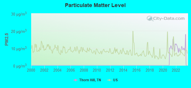
Particulate Matter (PM2.5) [µg/m3] level in 2022 was 9.68. This is about average. Closest monitor was 23.6 miles away from the city center.
| City: | 9.68 |
| U.S.: | 8.11 |
Tornado activity:
Thorn Hill-area historical tornado activity is significantly below Tennessee state average. It is 56% smaller than the overall U.S. average.
On 5/9/1988, a category F3 (max. wind speeds 158-206 mph) tornado 19.8 miles away from the Thorn Hill place center killed one person and injured 15 people and caused between $5,000,000 and $50,000,000 in damages.
On 2/21/1993, a category F3 tornado 36.1 miles away from the place center injured 3 people and caused between $500,000 and $5,000,000 in damages.
Earthquake activity:
Thorn Hill-area historical earthquake activity is significantly above Tennessee state average. It is 58% greater than the overall U.S. average.On 7/27/1980 at 18:52:21, a magnitude 5.2 (5.1 MB, 4.7 MS, 5.0 UK, 5.2 UK, Class: Moderate, Intensity: VI - VII) earthquake occurred 129.5 miles away from the city center
On 8/9/2020 at 12:07:37, a magnitude 5.1 (5.1 MW, Depth: 4.7 mi) earthquake occurred 129.8 miles away from the city center
On 11/30/1973 at 07:48:41, a magnitude 4.7 (4.7 MB, 4.6 ML, Class: Light, Intensity: IV - V) earthquake occurred 50.1 miles away from Thorn Hill center
On 8/23/2011 at 17:51:04, a magnitude 5.8 (5.8 MW, Depth: 3.7 mi) earthquake occurred 320.5 miles away from the city center
On 4/29/2003 at 08:59:39, a magnitude 4.9 (4.4 MB, 4.6 MW, 4.9 LG) earthquake occurred 180.1 miles away from Thorn Hill center
On 8/2/1974 at 08:52:09, a magnitude 4.9 (4.3 MB, 4.9 LG) earthquake occurred 181.3 miles away from Thorn Hill center
Magnitude types: regional Lg-wave magnitude (LG), body-wave magnitude (MB), local magnitude (ML), surface-wave magnitude (MS), moment magnitude (MW)
Natural disasters:
The number of natural disasters in Grainger County (14) is near the US average (15).Major Disasters (Presidential) Declared: 9
Emergencies Declared: 2
Causes of natural disasters: Floods: 9, Storms: 7, Tornadoes: 3, Heavy Rains: 2, Winter Storms: 2, Fire: 1, Flash Flood: 1, Hurricane: 1, Landslide: 1, Mudslide: 1, Snowfall: 1, Wind: 1, Other: 1 (Note: some incidents may be assigned to more than one category).
Hospitals and medical centers near Thorn Hill:
- CLAIBORNE HOME HEALTH CARE (Home Health Center, about 10 miles away; TAZEWELL, TN)
- CLAIBORNE COUNTY HOSPITAL Acute Care Hospitals (about 10 miles away; TAZEWELL, TN)
- AMEDISYS HOME HEALTH OF TENNESSEE (Home Health Center, about 11 miles away; TAZEWELL, TN)
- LAUREL MANOR HEALTH CARE (Nursing Home, about 11 miles away; NEW TAZEWELL, TN)
- APPALACHIAN DIALYSIS (Dialysis Facility, about 11 miles away; NEW TAZEWELL, TN)
- INTERIM HEALTH CARE OF EAST TENNESSEE (Home Health Center, about 13 miles away; MORRISTOWN, TN)
- HERITAGE CENTER, THE (Nursing Home, about 13 miles away; MORRISTOWN, TN)
Colleges/universities with over 2000 students nearest to Thorn Hill:
- Walters State Community College (about 15 miles; Morristown, TN; Full-time enrollment: 4,359)
- Lincoln Memorial University (about 20 miles; Harrogate, TN; FT enrollment: 3,706)
- Tusculum College (about 40 miles; Greeneville, TN; FT enrollment: 2,070)
- The University of Tennessee-Knoxville (about 41 miles; Knoxville, TN; FT enrollment: 25,483)
- Southeast Kentucky Community and Technical College (about 48 miles; Cumberland, KY; FT enrollment: 2,196)
- University of the Cumberlands (about 48 miles; Williamsburg, KY; FT enrollment: 3,585)
- Pellissippi State Community College (about 52 miles; Knoxville, TN; FT enrollment: 7,271)
Points of interest:
Notable locations in Thorn Hill: Coffman Camp (A), Thorn Hill Volunteer Fire Department (B). Display/hide their locations on the map
Churches in Thorn Hill include: Mount Pleasant Church (A), Coffey Chapel (B), Leaven Church (C), Liberty Church (D), Dotson Campground Church (E), Beech Grove Church (F), Thorn Hill Church (G), Oak Hill Church (H), Cedar Springs Church (I). Display/hide their locations on the map
Cemeteries: White Cemetery (1), Lamb Cemetery (2), Lathin Cemetery (3), Adkins Cemetery (4), Mallicoat Cemetery (5), Broken Valley Cemetery (6), McGinnis Cemetery (7). Display/hide their locations on the map
Streams, rivers, and creeks: Machine Branch (A), Joe Mill Creek (B), Indian Creek (C), Forked Deer Creek (D), Cracker Creek (E), Cedar Springs Creek (F), Patterson Branch (G), Notchy Creek (H), Rucker Branch (I). Display/hide their locations on the map
Hotel: Clinch Mountain Look-Out Restaurant & Gift (190 Lookout Mountain Road) (1). Display/hide its approximate location on the map
Drinking water stations with addresses in Thorn Hill and their reported violations in the past:
CLINCH MOUNTAIN LOOKOUT REST. (Population served: 110, Groundwater):Past monitoring violations:PARKWAY MARKET (Population served: 75, Groundwater):
- 2 routine major monitoring violations
Past monitoring violations:
- One routine major monitoring violation
| This place: | 2.5 people |
| Tennessee: | 2.5 people |
| This place: | 67.1% |
| Whole state: | 69.8% |
| This place: | 2.8% |
| Whole state: | 4.2% |
Likely homosexual households (counted as self-reported same-sex unmarried-partner households)
- Lesbian couples: 0.2% of all households
- Gay men: 0.2% of all households
| This place: | 21.9% |
| Whole state: | 13.5% |
| This place: | 4.6% |
| Whole state: | 5.8% |
For population 15 years and over in Thorn Hill:
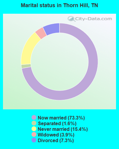
- Never married: 15.4%
- Now married: 73.3%
- Separated: 1.6%
- Widowed: 3.9%
- Divorced: 7.3%
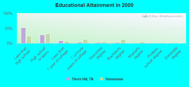
For population 25 years and over in Thorn Hill:
- High school or higher: 47.5%
- Bachelor's degree or higher: 3.4%
- Graduate or professional degree: 0.0%
- Unemployed: 3.1%
- Mean travel time to work (commute): 31.2 minutes
| Here: | 18.8 |
| Tennessee average: | 13.3 |
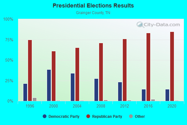
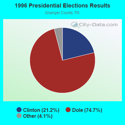
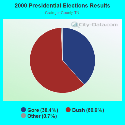
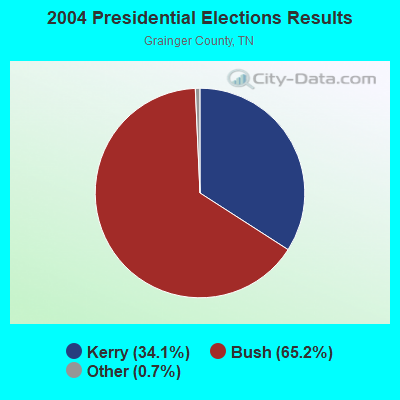
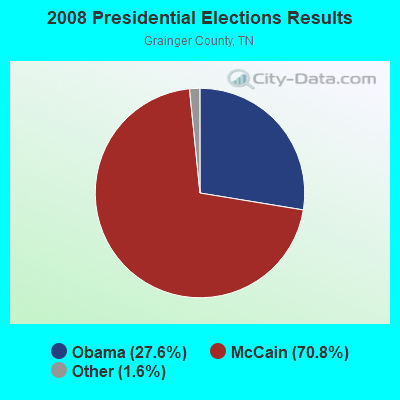
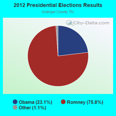


Graphs represent county-level data. Detailed 2008 Election Results
Religion statistics for Thorn Hill, TN (based on Grainger County data)
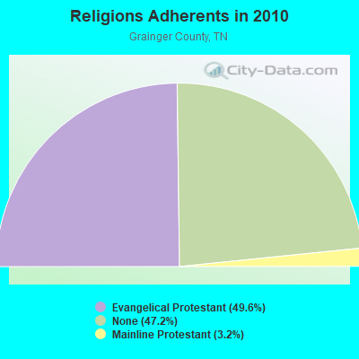
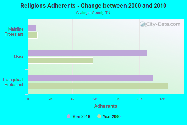
| Religion | Adherents | Congregations |
|---|---|---|
| Evangelical Protestant | 11,233 | 48 |
| Mainline Protestant | 728 | 10 |
| Other | 5 | 1 |
| Catholic | - | 1 |
| None | 10,691 | - |
Food Environment Statistics:
| Here: | 2.22 / 10,000 pop. |
| Tennessee: | 1.99 / 10,000 pop. |
| Here: | 5.77 / 10,000 pop. |
| Tennessee: | 5.16 / 10,000 pop. |
| This county: | 1.78 / 10,000 pop. |
| Tennessee: | 6.56 / 10,000 pop. |
| Grainger County: | 11.5% |
| Tennessee: | 11.4% |
| Grainger County: | 28.4% |
| Tennessee: | 30.2% |
| Grainger County: | 15.0% |
| Tennessee: | 13.5% |
Strongest AM radio stations in Thorn Hill:
- WKVL (850 AM; daytime; 50 kW; KNOXVILLE, TN; Owner: HORNE RADIO, LLC)
- WCRK (1150 AM; 5 kW; MORRISTOWN, TN; Owner: RADIO ACQUISITION CORP.)
- WMTN (1300 AM; 5 kW; MORRISTOWN, TN)
- WNOX (990 AM; 10 kW; KNOXVILLE, TN)
- WFGW (1010 AM; 50 kW; BLACK MOUNTAIN, NC; Owner: BLUE RIDGE BROADCASTING CORP.)
- WMIK (560 AM; 2 kW; MIDDLESBORO, KY; Owner: GATEWAY BROADCASTING, INC.)
- WVLZ (1180 AM; daytime; 10 kW; KNOXVILLE, TN; Owner: KIRKLAND WIRELESS BROADCASTERS, INC.)
- WRJZ (620 AM; 5 kW; KNOXVILLE, TN; Owner: TENNESSEE MEDIA ASSOCIATES, INC)
- WQBB (1040 AM; daytime; 10 kW; POWELL, TN; Owner: JOURNAL BROADCAST CORPORATION)
- WLFJ (660 AM; daytime; 50 kW; GREENVILLE, SC; Owner: CLEAR CHANNEL BROADCASTING LICENSES, INC.)
- WGOC (640 AM; 10 kW; BLOUNTVILLE, TN; Owner: CITADEL BROADCASTING COMPANY)
- WNTT (1250 AM; 0 kW; TAZEWELL, TN; Owner: WNTT, INC.)
- WFSR (970 AM; 5 kW; HARLAN, KY; Owner: EASTERN BROADCASTING COMPAY)
Strongest FM radio stations in Thorn Hill:
- WCTU (105.9 FM; TAZEWELL, TN; Owner: STAIR COMPANY, INC)
- WBGQ (100.7 FM; BULLS GAP, TN; Owner: CHEROKEE BROADCASTING)
- WMXK (94.1 FM; MORRISTOWN, TN; Owner: HORNE RADIO, LLC)
- WJDT (106.5 FM; ROGERSVILLE, TN; Owner: C & S BROADCASTING)
- WIMZ-FM (103.5 FM; KNOXVILLE, TN; Owner: SOUTH CENTRAL COMM., CORP.)
- WMIK-FM (92.7 FM; MIDDLESBORO, KY; Owner: GATEWAY BROADCASTING, INC.)
- WIVK-FM (107.7 FM; KNOXVILLE, TN; Owner: CITADEL BROADCASTING COMPANY)
- WWST (102.1 FM; SEVIERVILLE, TN; Owner: JOURNAL BROADCAST CORPORATION)
- WOKI-FM (100.3 FM; OAK RIDGE, TN; Owner: OAK RIDGE FM, INC.)
- WTFM (98.5 FM; KINGSPORT, TN; Owner: HOLSTON VALLEY BROADCASTING CORP.)
- WUOT (91.9 FM; KNOXVILLE, TN; Owner: UNIVERSITY OF TENNESSEE)
- WDVX (89.9 FM; CLINTON, TN; Owner: CUMBERLAND COMMUNITIES COMMUNI CORP.)
- WAXM (93.5 FM; BIG STONE GAP, VA; Owner: VALLEY BROADCASTING, INC.)
- WSEH (102.7 FM; CUMBERLAND, KY; Owner: CUMBERLAND CITY BROADCASTING, INC.)
- WEZG (99.3 FM; JEFFERSON CITY, TN; Owner: EAST TENNESSEE RADIO GROUP, L.P.)
- WJXB-FM (97.5 FM; KNOXVILLE, TN; Owner: SOUTH CENTRAL COMMUNICATIONS CORP.)
- WNPC-FM (92.9 FM; NEWPORT, TN; Owner: HARRIS BROADCASTING INC DBA WNPC INC)
- WMIT (106.9 FM; BLACK MOUNTAIN, NC; Owner: BLUE RIDGE BROADCASTING CORPORATION)
- WNCW (88.7 FM; SPINDALE, NC; Owner: ISOTHERMAL COMMUNITY COLLEGE)
- WRIL (106.3 FM; PINEVILLE, KY; Owner: PINE HILLS BROADCASTING, INC.)
TV broadcast stations around Thorn Hill:
- WKOP-TV (Channel 15; KNOXVILLE, TN; Owner: EAST TENNESSEE PUBLIC COMMUNICATIONS CORP.)
- WBIR-TV (Channel 10; KNOXVILLE, TN; Owner: GANNETT PACIFIC CORPORATION)
- WVLT-TV (Channel 8; KNOXVILLE, TN; Owner: WVLT LICENSEE CORP.)
- WATE-TV (Channel 6; KNOXVILLE, TN; Owner: WATE, G.P.)
- WTNZ (Channel 43; KNOXVILLE, TN; Owner: RAYCOM AMERICA, INC.)
- WVLR (Channel 48; TAZEWELL, TN; Owner: VOLUNTEER CHRISTIAN TELEVISION, INC.)
- WEEE-LP (Channel 32; KNOXVILLE, TN; Owner: TIGER EYE BROADCASTING CORPORATION)
- WETP-TV (Channel 2; SNEEDVILLE, TN; Owner: EAST TENNESSEE PUBLIC COMMUNICATIONS CORP.)
- WEZK-LP (Channel 28; KNOXVILLE, TN; Owner: SOUTH CENTRAL COMMUNICATIONS CORP.)
- WAGV (Channel 44; HARLAN, KY; Owner: LIVING FAITH MINISTRIES, INC.)
Thorn Hill fatal accident list:
2004 - 2018 National Fire Incident Reporting System (NFIRS) incidents
- Fire incident types reported to NFIRS in Thorn Hill, TN
- 4140.6%Structure Fires
- 3534.7%Outside Fires
- 1918.8%Mobile Property/Vehicle Fires
- 65.9%Other
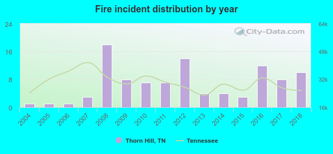 According to the data from the years 2004 - 2018 the average number of fire incidents per year is 7. The highest number of reported fire incidents - 18 took place in 2008, and the least - 1 in 2004. The data has an increasing trend.
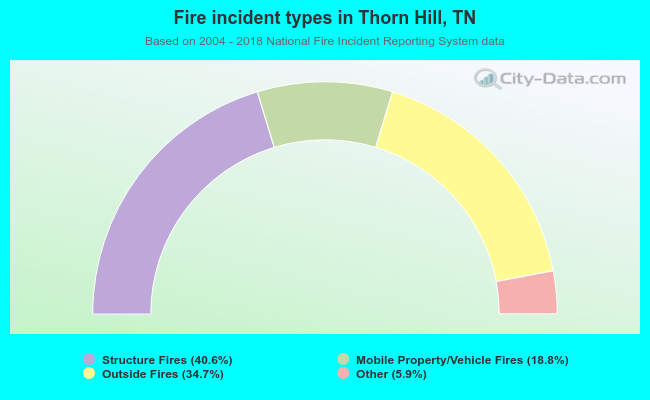 When looking into fire subcategories, the most reports belonged to: Structure Fires (40.6%), and Outside Fires (34.7%).
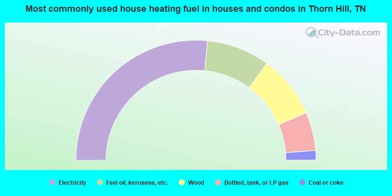
- 53.1%Electricity
- 17.0%Fuel oil, kerosene, etc.
- 17.0%Wood
- 10.3%Bottled, tank, or LP gas
- 2.6%Coal or coke
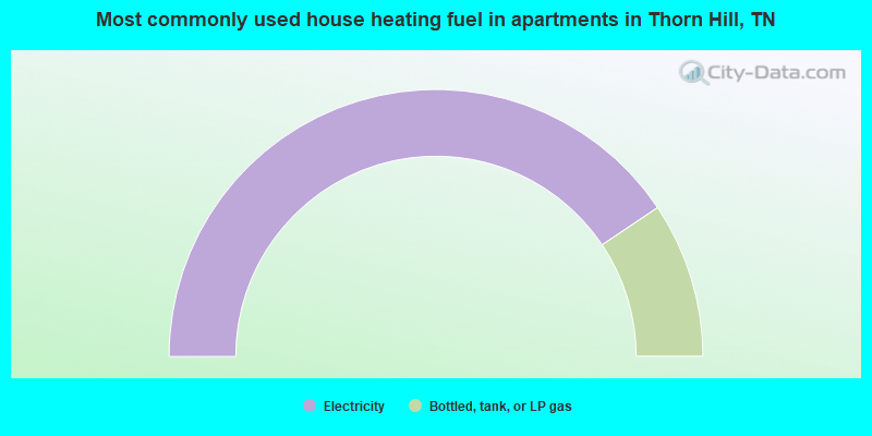
- 81.2%Electricity
- 18.8%Bottled, tank, or LP gas
Thorn Hill compared to Tennessee state average:
- Median household income below state average.
- Median house value below state average.
- Unemployed percentage significantly below state average.
- Black race population percentage significantly below state average.
- Hispanic race population percentage significantly below state average.
- Foreign-born population percentage significantly below state average.
- Renting percentage significantly below state average.
- Length of stay since moving in significantly above state average.
- Number of rooms per house significantly below state average.
- House age significantly below state average.
- Number of college students below state average.
- Percentage of population with a bachelor's degree or higher significantly below state average.