Washburn, Tennessee
Submit your own pictures of this place and show them to the world
- OSM Map
- General Map
- Google Map
- MSN Map

| Males: 1,329 | |
| Females: 1,405 |
| Median resident age: | 36.9 years |
| Tennessee median age: | 35.9 years |
Zip code: 37888
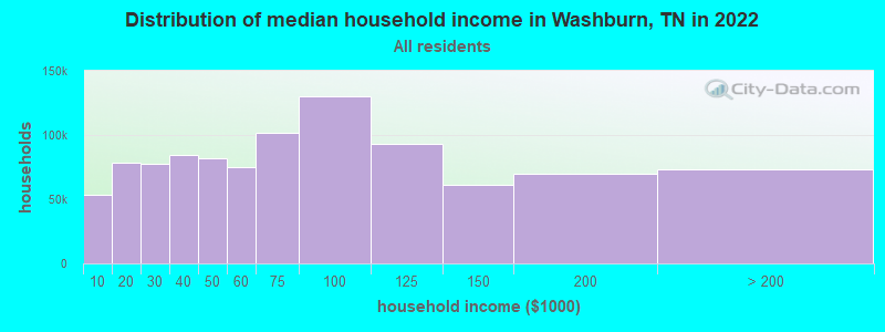
| Washburn: | $42,987 |
| TN: | $65,254 |
Estimated per capita income in 2022: $25,424 (it was $13,641 in 2000)
Washburn CCD income, earnings, and wages data
Estimated median house or condo value in 2022: $157,929 (it was $55,500 in 2000)
| Washburn: | $157,929 |
| TN: | $284,800 |
Mean prices in 2022: all housing units: $241,672; detached houses: $298,546; townhouses or other attached units: $172,174; mobile homes: $84,814; occupied boats, rvs, vans, etc.: $54,184
Detailed information about poverty and poor residents in Washburn, TN


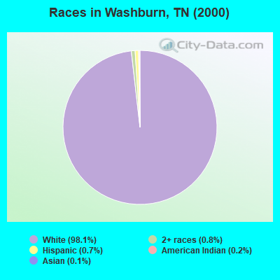
- 2,46198.1%White alone
- 210.8%Two or more races
- 170.7%Hispanic
- 50.2%American Indian alone
- 30.1%Asian alone
- 10.04%Native Hawaiian and Other
Pacific Islander alone
Races in Washburn detailed stats: ancestries, foreign born residents, place of birth
According to our research of Tennessee and other state lists, there were 6 registered sex offenders living in Washburn, Tennessee as of May 15, 2024.
The ratio of all residents to sex offenders in Washburn is 456 to 1.
The ratio of registered sex offenders to all residents in this city is lower than the state average.
 Recent articles from our blog. Our writers, many of them Ph.D. graduates or candidates, create easy-to-read articles on a wide variety of topics.
Current Local Time: EST time zone
Elevation: 1404 feet
Land area: 56.2 square miles.
Population density: 49 people per square mile (very low).

| Washburn CCD: | 0.4% ($235) |
| Tennessee: | 0.8% ($715) |
Nearest city with pop. 50,000+: Knoxville, TN  (29.3 miles , pop. 173,890).
Nearest city with pop. 200,000+: Fayette, KY (129.3 miles , pop. 260,512).
Nearest city with pop. 1,000,000+: Chicago, IL (441.2 miles , pop. 2,896,016).
Nearest cities:
), ), ), Latitude: 36.30 N, Longitude: 83.61 W
Area code: 865

| Here: | 3.2% |
| Tennessee: | 3.0% |
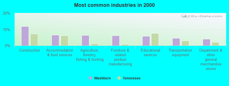
- Construction (11.8%)
- Accommodation & food services (6.6%)
- Agriculture, forestry, fishing & hunting (6.4%)
- Furniture & related product manufacturing (6.3%)
- Educational services (5.9%)
- Transportation equipment (4.6%)
- Department & other general merchandise stores (4.1%)
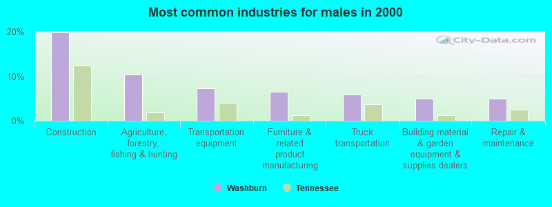
- Construction (19.9%)
- Agriculture, forestry, fishing & hunting (10.4%)
- Transportation equipment (7.4%)
- Furniture & related product manufacturing (6.5%)
- Truck transportation (5.8%)
- Building material & garden equipment & supplies dealers (5.0%)
- Repair & maintenance (5.0%)
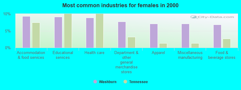
- Accommodation & food services (9.3%)
- Educational services (9.1%)
- Health care (8.8%)
- Department & other general merchandise stores (7.7%)
- Apparel (7.1%)
- Miscellaneous manufacturing (7.1%)
- Food & beverage stores (6.9%)
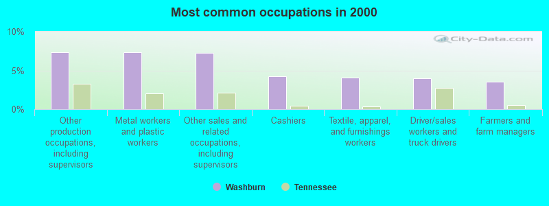
- Other production occupations, including supervisors (7.3%)
- Metal workers and plastic workers (7.3%)
- Other sales and related occupations, including supervisors (7.2%)
- Cashiers (4.2%)
- Textile, apparel, and furnishings workers (4.1%)
- Driver/sales workers and truck drivers (4.0%)
- Farmers and farm managers (3.6%)
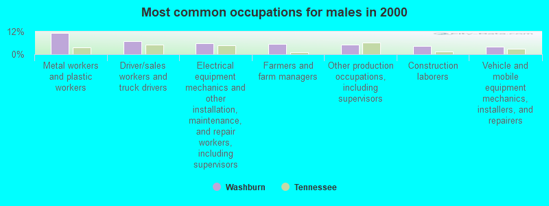
- Metal workers and plastic workers (11.3%)
- Driver/sales workers and truck drivers (7.0%)
- Electrical equipment mechanics and other installation, maintenance, and repair workers, including supervisors (6.0%)
- Farmers and farm managers (5.5%)
- Other production occupations, including supervisors (5.1%)
- Construction laborers (4.3%)
- Vehicle and mobile equipment mechanics, installers, and repairers (4.1%)
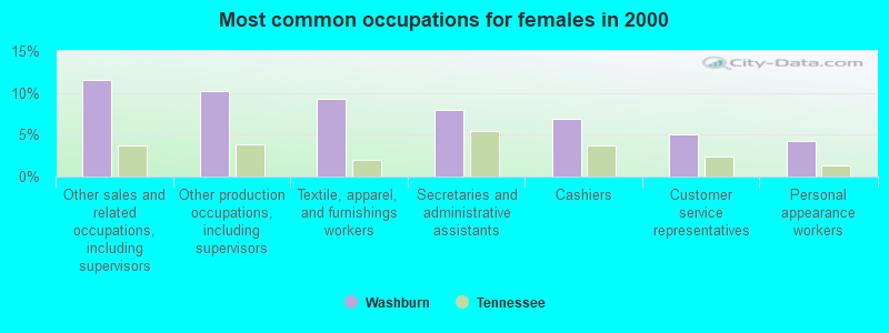
- Other sales and related occupations, including supervisors (11.5%)
- Other production occupations, including supervisors (10.2%)
- Textile, apparel, and furnishings workers (9.3%)
- Secretaries and administrative assistants (8.0%)
- Cashiers (6.9%)
- Customer service representatives (5.1%)
- Personal appearance workers (4.2%)
Average climate in Washburn, Tennessee
Based on data reported by over 4,000 weather stations


(lower is better)
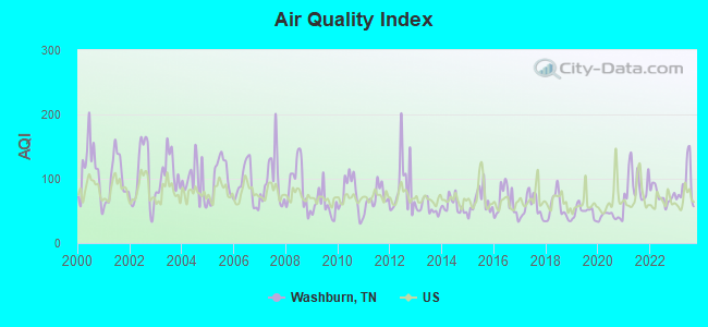
Air Quality Index (AQI) level in 2023 was 90.0. This is worse than average.
| City: | 90.0 |
| U.S.: | 72.6 |
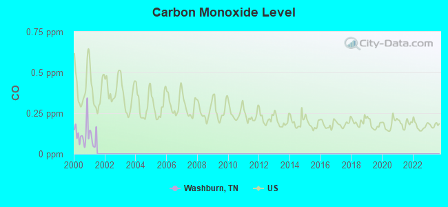
Carbon Monoxide (CO) [ppm] level in 2000 was 0.127. This is significantly better than average. Closest monitor was 15.0 miles away from the city center.
| City: | 0.127 |
| U.S.: | 0.251 |
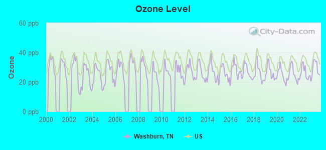
Ozone [ppb] level in 2023 was 29.7. This is about average. Closest monitor was 9.4 miles away from the city center.
| City: | 29.7 |
| U.S.: | 33.3 |
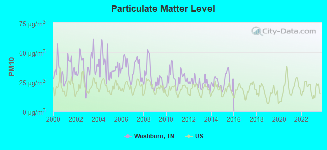
Particulate Matter (PM10) [µg/m3] level in 2015 was 26.0. This is worse than average. Closest monitor was 7.5 miles away from the city center.
| City: | 26.0 |
| U.S.: | 19.2 |
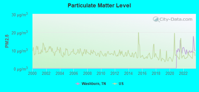
Particulate Matter (PM2.5) [µg/m3] level in 2023 was 11.0. This is worse than average. Closest monitor was 22.6 miles away from the city center.
| City: | 11.0 |
| U.S.: | 8.1 |
Tornado activity:
Washburn-area historical tornado activity is significantly below Tennessee state average. It is 48% smaller than the overall U.S. average.
On 5/9/1988, a category F3 (max. wind speeds 158-206 mph) tornado 21.0 miles away from the Washburn place center killed one person and injured 15 people and caused between $5,000,000 and $50,000,000 in damages.
On 2/21/1993, a category F3 tornado 24.4 miles away from the place center injured 3 people and caused between $500,000 and $5,000,000 in damages.
Earthquake activity:
Washburn-area historical earthquake activity is significantly above Tennessee state average. It is 65% greater than the overall U.S. average.On 7/27/1980 at 18:52:21, a magnitude 5.2 (5.1 MB, 4.7 MS, 5.0 UK, 5.2 UK, Class: Moderate, Intensity: VI - VII) earthquake occurred 133.2 miles away from Washburn center
On 11/30/1973 at 07:48:41, a magnitude 4.7 (4.7 MB, 4.6 ML, Class: Light, Intensity: IV - V) earthquake occurred 39.8 miles away from the city center
On 8/9/2020 at 12:07:37, a magnitude 5.1 (5.1 MW, Depth: 4.7 mi) earthquake occurred 140.5 miles away from Washburn center
On 8/23/2011 at 17:51:04, a magnitude 5.8 (5.8 MW, Depth: 3.7 mi) earthquake occurred 332.0 miles away from the city center
On 4/29/2003 at 08:59:39, a magnitude 4.9 (4.4 MB, 4.6 MW, 4.9 LG) earthquake occurred 169.0 miles away from Washburn center
On 8/2/1974 at 08:52:09, a magnitude 4.9 (4.3 MB, 4.9 LG) earthquake occurred 179.4 miles away from the city center
Magnitude types: regional Lg-wave magnitude (LG), body-wave magnitude (MB), local magnitude (ML), surface-wave magnitude (MS), moment magnitude (MW)
Natural disasters:
The number of natural disasters in Grainger County (14) is near the US average (15).Major Disasters (Presidential) Declared: 9
Emergencies Declared: 2
Causes of natural disasters: Floods: 9, Storms: 7, Tornadoes: 3, Heavy Rains: 2, Winter Storms: 2, Fire: 1, Flash Flood: 1, Hurricane: 1, Landslide: 1, Mudslide: 1, Snowfall: 1, Wind: 1, Other: 1 (Note: some incidents may be assigned to more than one category).
Hospitals and medical centers near Washburn:
- APPALACHIAN DIALYSIS (Dialysis Facility, about 10 miles away; NEW TAZEWELL, TN)
- WARIOTA HLTH CARE CTR (Nursing Home, about 10 miles away; MAYNARDVILLE, TN)
- WILLOW RIDGE CARE AND REHABILITATION CENTER (Nursing Home, about 10 miles away; MAYNARDVILLE, TN)
- CLAIBORNE HOME HEALTH CARE (Home Health Center, about 11 miles away; TAZEWELL, TN)
- AMEDISYS HOME HEALTH OF TENNESSEE (Home Health Center, about 11 miles away; TAZEWELL, TN)
- LAUREL MANOR HEALTH CARE (Nursing Home, about 11 miles away; NEW TAZEWELL, TN)
- CLAIBORNE COUNTY HOSPITAL Acute Care Hospitals (about 11 miles away; TAZEWELL, TN)
Colleges/universities with over 2000 students nearest to Washburn:
- Lincoln Memorial University (about 20 miles; Harrogate, TN; Full-time enrollment: 3,706)
- Walters State Community College (about 21 miles; Morristown, TN; FT enrollment: 4,359)
- The University of Tennessee-Knoxville (about 30 miles; Knoxville, TN; FT enrollment: 25,483)
- Pellissippi State Community College (about 40 miles; Knoxville, TN; FT enrollment: 7,271)
- University of the Cumberlands (about 44 miles; Williamsburg, KY; FT enrollment: 3,585)
- Tusculum College (about 48 miles; Greeneville, TN; FT enrollment: 2,070)
- Southeast Kentucky Community and Technical College (about 58 miles; Cumberland, KY; FT enrollment: 2,196)
Public high school in Washburn:
- WASHBURN SCHOOL (Students: 642, Location: 7925 HWY 131, Grades: PK-12)
Points of interest:
Notable locations in Washburn: Dutch (A), Black Fox (B), Washburn Volunteer Fire Department (C). Display/hide their locations on the map
Churches in Washburn include: Salem Church (A), Fairview Church (B), Locust Grove Church (C), Dutch Valley Church (D), Powder Springs Church (E), Liberty Hill Church (F), Elm Springs United Baptist Church of Jesus Christ (G), Black Fox Primitive Baptist Church (H), Beeler Chapel (I). Display/hide their locations on the map
Cemeteries: Hopson Cemetery (1), Scott Cemetery (2), Thomas Cemetery (3), Seymoure Cemetery (4), Johnson Cemetery (5), Warter Cemetery (6), Kitts Cemetery (7). Display/hide their locations on the map
Streams, rivers, and creeks: Hogskin Creek (A), Fox Creek (B), Dutch Valley Creek (C), Dotson Creek (D), Cool Branch (E), Edderson Branch (F), Williams Creek (G), Puncheon Camp Creek (H). Display/hide their locations on the map
| This place: | 2.5 people |
| Tennessee: | 2.5 people |
| This place: | 65.9% |
| Whole state: | 69.8% |
| This place: | 2.3% |
| Whole state: | 4.2% |
Likely homosexual households (counted as self-reported same-sex unmarried-partner households)
- Lesbian couples: 0.1% of all households
- Gay men: 0.1% of all households
| This place: | 20.2% |
| Whole state: | 13.5% |
| This place: | 3.7% |
| Whole state: | 5.8% |
Banks with branches in Washburn (2011 data):
- Citizens Bank and Trust Company of Grainger County: Liberty Hill Branch at 125 Washburn Road, branch established on 1988/10/17. Info updated 2010/06/14: Bank assets: $181.4 mil, Deposits: $148.7 mil, headquarters in Rutledge, TN, positive income, 5 total offices, Holding Company: Citizens Of Grainger County Corporation
For population 15 years and over in Washburn:
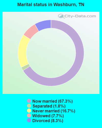
- Never married: 16.7%
- Now married: 67.3%
- Separated: 1.8%
- Widowed: 7.7%
- Divorced: 8.3%
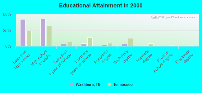
For population 25 years and over in Washburn:
- High school or higher: 57.9%
- Bachelor's degree or higher: 4.8%
- Graduate or professional degree: 1.2%
- Unemployed: 4.7%
- Mean travel time to work (commute): 38.0 minutes
| Here: | 14.7 |
| Tennessee average: | 13.3 |
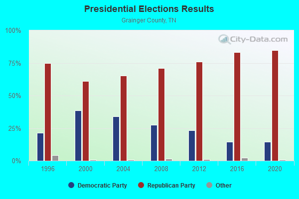
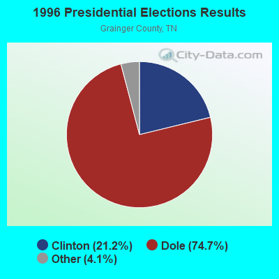
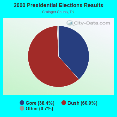
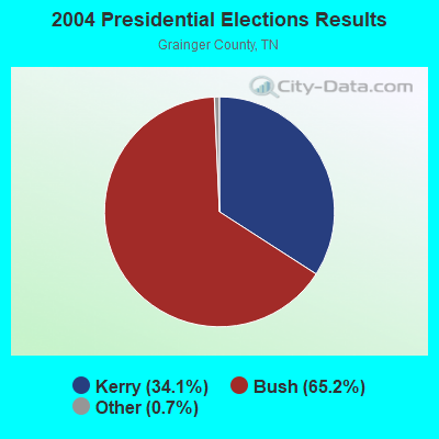
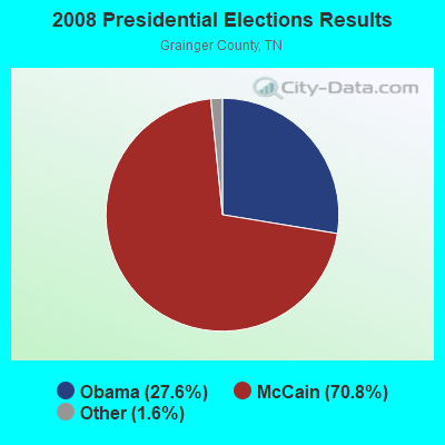
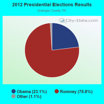

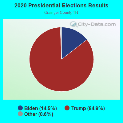
Graphs represent county-level data. Detailed 2008 Election Results
Religion statistics for Washburn, TN (based on Grainger County data)
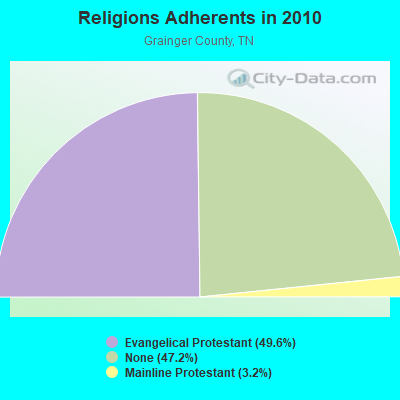
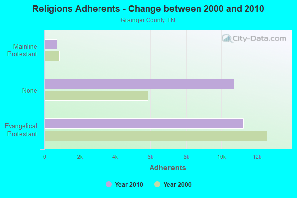
| Religion | Adherents | Congregations |
|---|---|---|
| Evangelical Protestant | 11,233 | 48 |
| Mainline Protestant | 728 | 10 |
| Other | 5 | 1 |
| Catholic | - | 1 |
| None | 10,691 | - |
Food Environment Statistics:
| Grainger County: | 2.22 / 10,000 pop. |
| Tennessee: | 1.99 / 10,000 pop. |
| Grainger County: | 5.77 / 10,000 pop. |
| Tennessee: | 5.16 / 10,000 pop. |
| Grainger County: | 1.78 / 10,000 pop. |
| State: | 6.56 / 10,000 pop. |
| This county: | 11.5% |
| Tennessee: | 11.4% |
| Here: | 28.4% |
| Tennessee: | 30.2% |
| Grainger County: | 15.0% |
| State: | 13.5% |
Strongest AM radio stations in Washburn:
- WKVL (850 AM; daytime; 50 kW; KNOXVILLE, TN; Owner: HORNE RADIO, LLC)
- WNOX (990 AM; 10 kW; KNOXVILLE, TN)
- WCRK (1150 AM; 5 kW; MORRISTOWN, TN; Owner: RADIO ACQUISITION CORP.)
- WMTN (1300 AM; 5 kW; MORRISTOWN, TN)
- WVLZ (1180 AM; daytime; 10 kW; KNOXVILLE, TN; Owner: KIRKLAND WIRELESS BROADCASTERS, INC.)
- WRJZ (620 AM; 5 kW; KNOXVILLE, TN; Owner: TENNESSEE MEDIA ASSOCIATES, INC)
- WQBB (1040 AM; daytime; 10 kW; POWELL, TN; Owner: JOURNAL BROADCAST CORPORATION)
- WMIK (560 AM; 2 kW; MIDDLESBORO, KY; Owner: GATEWAY BROADCASTING, INC.)
- WFGW (1010 AM; 50 kW; BLACK MOUNTAIN, NC; Owner: BLUE RIDGE BROADCASTING CORP.)
- WSEV (930 AM; 5 kW; SEVIERVILLE, TN; Owner: EAST TENNESSEE RADIO GROUP, L.P.)
- WLFJ (660 AM; daytime; 50 kW; GREENVILLE, SC; Owner: CLEAR CHANNEL BROADCASTING LICENSES, INC.)
- WMEN (760 AM; daytime; 2 kW; KNOXVILLE, TN; Owner: THOMAS MOFFIT JR.)
- WLIK (1270 AM; 5 kW; NEWPORT, TN; Owner: WLIK, INC)
Strongest FM radio stations in Washburn:
- WIMZ-FM (103.5 FM; KNOXVILLE, TN; Owner: SOUTH CENTRAL COMM., CORP.)
- WCTU (105.9 FM; TAZEWELL, TN; Owner: STAIR COMPANY, INC)
- WMIK-FM (92.7 FM; MIDDLESBORO, KY; Owner: GATEWAY BROADCASTING, INC.)
- WOKI-FM (100.3 FM; OAK RIDGE, TN; Owner: OAK RIDGE FM, INC.)
- WMXK (94.1 FM; MORRISTOWN, TN; Owner: HORNE RADIO, LLC)
- WUOT (91.9 FM; KNOXVILLE, TN; Owner: UNIVERSITY OF TENNESSEE)
- WIVK-FM (107.7 FM; KNOXVILLE, TN; Owner: CITADEL BROADCASTING COMPANY)
- WWST (102.1 FM; SEVIERVILLE, TN; Owner: JOURNAL BROADCAST CORPORATION)
- WBGQ (100.7 FM; BULLS GAP, TN; Owner: CHEROKEE BROADCASTING)
- WDVX (89.9 FM; CLINTON, TN; Owner: CUMBERLAND COMMUNITIES COMMUNI CORP.)
- WEZG (99.3 FM; JEFFERSON CITY, TN; Owner: EAST TENNESSEE RADIO GROUP, L.P.)
- WJXB-FM (97.5 FM; KNOXVILLE, TN; Owner: SOUTH CENTRAL COMMUNICATIONS CORP.)
- WJDT (106.5 FM; ROGERSVILLE, TN; Owner: C & S BROADCASTING)
- WRMX-FM (106.7 FM; NORRIS, TN; Owner: SOUTH CENTRAL COMMUNICATIONS CORPORATION)
- WYLV (89.1 FM; ALCOA, TN; Owner: FOOTHILLS BROADCASTING, INC.)
- WTFM (98.5 FM; KINGSPORT, TN; Owner: HOLSTON VALLEY BROADCASTING CORP.)
- W237AR (95.3 FM; HAZELWOOD, ETC., NC; Owner: WESTERN NORTH CAROLINA PUBLIC RADIO)
- WNPC-FM (92.9 FM; NEWPORT, TN; Owner: HARRIS BROADCASTING INC DBA WNPC INC)
- WRIL (106.3 FM; PINEVILLE, KY; Owner: PINE HILLS BROADCASTING, INC.)
- WAXM (93.5 FM; BIG STONE GAP, VA; Owner: VALLEY BROADCASTING, INC.)
TV broadcast stations around Washburn:
- WVLR (Channel 48; TAZEWELL, TN; Owner: VOLUNTEER CHRISTIAN TELEVISION, INC.)
- WKOP-TV (Channel 15; KNOXVILLE, TN; Owner: EAST TENNESSEE PUBLIC COMMUNICATIONS CORP.)
- WBIR-TV (Channel 10; KNOXVILLE, TN; Owner: GANNETT PACIFIC CORPORATION)
- WVLT-TV (Channel 8; KNOXVILLE, TN; Owner: WVLT LICENSEE CORP.)
- WATE-TV (Channel 6; KNOXVILLE, TN; Owner: WATE, G.P.)
- WTNZ (Channel 43; KNOXVILLE, TN; Owner: RAYCOM AMERICA, INC.)
- WEEE-LP (Channel 32; KNOXVILLE, TN; Owner: TIGER EYE BROADCASTING CORPORATION)
- WEZK-LP (Channel 28; KNOXVILLE, TN; Owner: SOUTH CENTRAL COMMUNICATIONS CORP.)
- WDTT-LP (Channel 38; LENOIR CITY, TN; Owner: WORD OF GOD FELLOWSHIP, INC.)
- W46DC (Channel 46; KNOXVILLE, TN; Owner: TRINITY BROADCASTING NETWORK)
- W50CG (Channel 50; KNOXVILLE, TN; Owner: THREE ANGELS BROADCASTING NETWORK, INC.)
- W56CM (Channel 56; KNOXVILLE, TN; Owner: VENTANA TELEVISION, INC.)
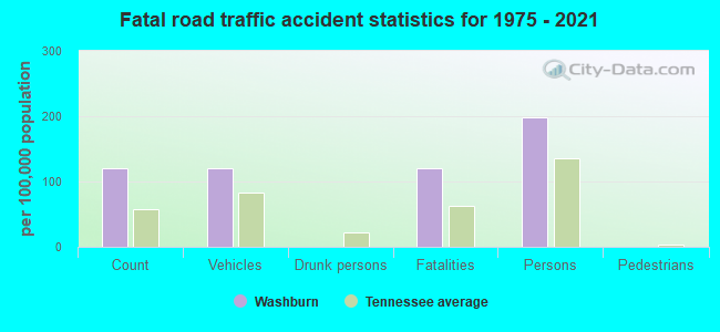
Washburn fatal accident list:
Jan 25, 2002 06:50 PM, Sr-131, Vehicles: 1, Persons: 2, Fatalities: 1
May 8, 1986 09:20 PM, Vehicles: 1, Persons: 2, Fatalities: 1
FCC Registered Antenna Towers:
12 (See the full list of FCC Registered Antenna Towers in Washburn)FCC Registered Microwave Towers:
1- Cracker Neck, 7908 Cracker Neck Rd (Lat: 36.325389 Lon: -83.586056), Type: Pole, Structure height: 42.7 m, Overall height: 44.2 m, Call Sign: WRFR459,
Assigned Frequencies: 11305.0 MHz, 11425.0 MHz, 11225.0 MHz, 11265.0 MHz, 11305.0 MHz, 11425.0 MHz, 11225.0 MHz, 11265.0 MHz, 11305.0 MHz, 11425.0 MHz... (+38 more), Grant Date: 04/16/2020, Expiration Date: 04/16/2030, Certifier: Bradley Hays, Registrant: Micronet Communications, Inc., 812 Lexington Dr, Plano, TX 75075, Phone: (972) 422-7200, Email:
FCC Registered Amateur Radio Licenses:
11 (See the full list of FCC Registered Amateur Radio Licenses in Washburn)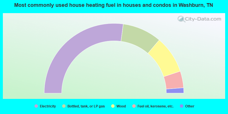
- 54.3%Electricity
- 18.2%Bottled, tank, or LP gas
- 17.4%Wood
- 7.7%Fuel oil, kerosene, etc.
- 1.4%No fuel used
- 1.1%Coal or coke
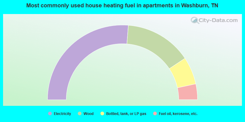
- 52.5%Electricity
- 28.8%Wood
- 11.9%Bottled, tank, or LP gas
- 6.8%Fuel oil, kerosene, etc.
Washburn compared to Tennessee state average:
- Median household income below state average.
- Median house value below state average.
- Unemployed percentage significantly below state average.
- Black race population percentage significantly below state average.
- Hispanic race population percentage significantly below state average.
- Foreign-born population percentage significantly below state average.
- Renting percentage significantly below state average.
- Length of stay since moving in significantly above state average.
- Number of rooms per house significantly below state average.
- House age significantly below state average.
- Number of college students below state average.
- Percentage of population with a bachelor's degree or higher significantly below state average.