Urbana, Iowa
Submit your own pictures of this city and show them to the world
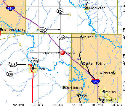
- OSM Map
- General Map
- Google Map
- MSN Map
Population change since 2000: +58.4%
| Males: 802 | |
| Females: 812 |
| Median resident age: | 32.6 years |
| Iowa median age: | 38.9 years |
Zip codes: 52345.
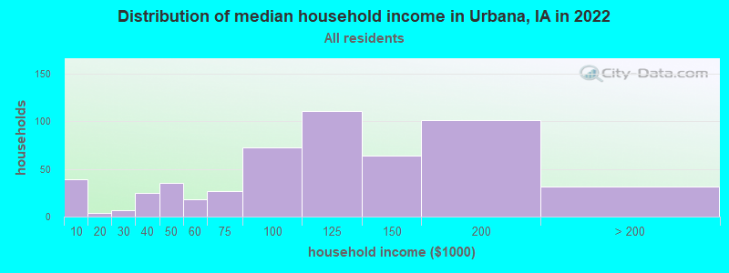
| Urbana: | $106,126 |
| IA: | $69,588 |
Estimated per capita income in 2022: $39,240 (it was $18,005 in 2000)
Urbana city income, earnings, and wages data
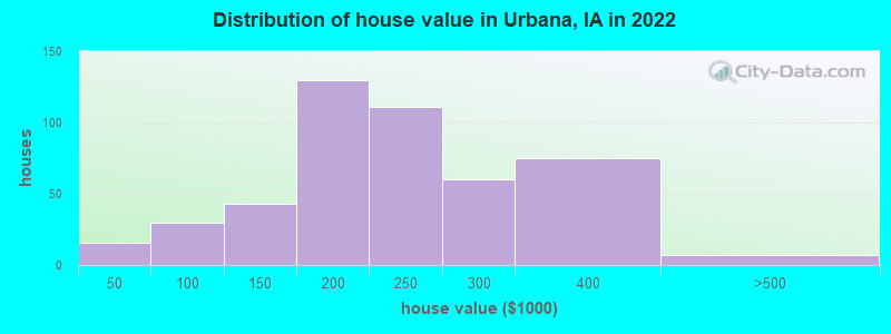
Estimated median house or condo value in 2022: $217,210 (it was $85,900 in 2000)
| Urbana: | $217,210 |
| IA: | $194,600 |
Median gross rent in 2022: $743.
(8.5% for White Non-Hispanic residents, 13.5% for Hispanic or Latino residents, 17.9% for two or more races residents)
Detailed information about poverty and poor residents in Urbana, IA
Compare current foreclosures near Urbana, IA:
| Photo | Address | Area | Beds / Baths | Price | Details |
|---|---|---|---|---|---|

|
#1
Park Ave
Center Point, IA 52213
|
1,040 sq. feet
|
1 baths 2 beds |
show details | |

|
#2
Grove St NW
Shellsburg, IA 52332
|
1,486 sq. feet
|
1 baths 3 beds |
show details | |

|
#3
W 12th St
Vinton, IA 52349
|
960 sq. feet
|
2 baths 3 beds |
show details | |

|
#4
Main St
Center Point, IA 52213
|
936 sq. feet
|
1 baths 3 beds |
show details | |

|
#5
Quail Trl NE
Cedar Rapids, IA 52402
|
1,140 sq. feet
|
2 baths 3 beds |
show details | |

|
#6
Sugar Pine Dr NE
Cedar Rapids, IA 52402
|
988 sq. feet
|
1 baths 4 beds |
show details | |

|
#7
Twin Pine Dr NE
Cedar Rapids, IA 52402
|
994 sq. feet
|
2 baths 4 beds |
show details | |

|
#8
E Main St
La Porte City, IA 50651
|
1,450 sq. feet
|
1 baths 3 beds |
show details | |

|
#9
Chaffee Dr
Hiawatha, IA 52233
|
1,870 sq. feet
|
2 baths 3 beds |
show details | |

|
#10
Seminole Valley Rd NE
Cedar Rapids, IA 52411
|
1,080 sq. feet
|
2 baths 3 beds |
show details |
| Photo | Address | Area | Beds / Baths | Price | Details |
|---|---|---|---|---|---|

|
#11
Cress Pkwy
Hiawatha, IA 52233
|
1,720 sq. feet
|
2 baths 3 beds |
show details | |

|
#12
N Mentzer Rd
Marion, IA 52302
|
3,938 sq. feet
|
3 baths 3 beds |
show details | |

|
#13
Purdy Rd
La Porte City, IA 50651
|
2,132 sq. feet
|
4 baths 4 beds |
show details | |

|
#14
Main St NW
Shellsburg, IA 52332
|
2,150 sq. feet
|
1 baths 3 beds |
show details | |

|
#15
Main St
Center Point, IA 52213
|
1,247 sq. feet
|
2 baths 4 beds |
show details | |

|
#16
Eagle Ct
Shellsburg, IA 52332
|
1,769 sq. feet
|
2 baths 3 beds |
show details | |

|
#17
W 3rd St
Vinton, IA 52349
|
2,116 sq. feet
|
6 baths 6 beds |
show details | |

|
#18
Northgate St NW
Shellsburg, IA 52332
|
2,108 sq. feet
|
3 baths 3 beds |
show details | |

|
#19
Boyson Ct
Hiawatha, IA 52233
|
8,750 sq. feet
|
1 baths - beds |
show details | |

|
#20
Lexington Dr NE Apt C
Cedar Rapids, IA 52402
|
- sq. feet
|
- baths - beds |
show details |
| Photo | Address | Area | Beds / Baths | Price | Details |
|---|---|---|---|---|---|

|
#21
Bettys Grove Rd
Walker, IA 52352
|
- sq. feet
|
- baths - beds |
show details | |

|
#22
6th Ave SW
Independence, IA 50644
|
- sq. feet
|
- baths - beds |
show details | |

|
#23
3rd St E
Newhall, IA 52315
|
- sq. feet
|
- baths - beds |
show details | |

|
#24
Forest Valley Ct NE
Cedar Rapids, IA 52411
|
- sq. feet
|
- baths - beds |
show details | |

|
#25
N Towne Ln NE
Cedar Rapids, IA 52402
|
- sq. feet
|
- baths - beds |
show details | |

|
#26
Jandel Ct
Toddville, IA 52341
|
- sq. feet
|
- baths - beds |
show details | |

|
#27
N River Blvd Ne, Apt 5
Cedar Rapids, IA 52411
|
- sq. feet
|
- baths - beds |
show details | |

|
#28
W 8th St
Vinton, IA 52349
|
- sq. feet
|
- baths - beds |
show details | |

|
#29
Kellie Ave SW
Independence, IA 50644
|
- sq. feet
|
- baths - beds |
show details | |

|
#30
Enterprise Ct, Apt 11
Independence, IA 50644
|
- sq. feet
|
- baths - beds |
show details |
| Photo | Address | Area | Beds / Baths | Price | Details |
|---|---|---|---|---|---|

|
#31
Wexford Way NE
Cedar Rapids, IA 52411
|
- sq. feet
|
- baths - beds |
show details | |

|
#32
Kilbirnie Rd
Robins, IA 52328
|
- sq. feet
|
- baths - beds |
show details | |

|
#33
7th Ave SW
Independence, IA 50644
|
- sq. feet
|
- baths - beds |
show details | |

|
#34
280th St Lot 2
Jesup, IA 50648
|
- sq. feet
|
- baths - beds |
show details | |

|
#35
W 2nd St
Vinton, IA 52349
|
- sq. feet
|
- baths - beds |
show details | |

|
#36
262nd St
Independence, IA 50644
|
- sq. feet
|
- baths - beds |
show details | |

|
#37
Wright Dr
Hiawatha, IA 52233
|
- sq. feet
|
- baths - beds |
show details | |

|
Check over 1 million property listings on Foreclosure.com!
|
browse all offers | |||


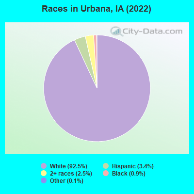
- 1,45292.5%White alone
- 543.4%Hispanic
- 392.5%Two or more races
- 140.9%Black alone
- 20.1%Other race alone
Races in Urbana detailed stats: ancestries, foreign born residents, place of birth
According to our research of Iowa and other state lists, there were 3 registered sex offenders living in Urbana, Iowa as of May 14, 2024.
The ratio of all residents to sex offenders in Urbana is 486 to 1.
The ratio of registered sex offenders to all residents in this city is near the state average.
 Recent articles from our blog. Our writers, many of them Ph.D. graduates or candidates, create easy-to-read articles on a wide variety of topics.

 | Why doesn't Clinton, IA capitalize on it's location? (12 replies) |
| Which City? (Cedar Rapids Area) (9 replies) |
| Iowa leads the nation in high school graduation rate. (26 replies) |
| Des Moines vs rural Iowa (19 replies) |
| Moving from Chicago to Cedar Falls Iowa, commute to Cedar Rapids (12 replies) |
| Do Iowans realize the impact of Univ of Iowa in Chicagoland? (16 replies) |
Latest news from Urbana, IA collected exclusively by city-data.com from local newspapers, TV, and radio stations
Ancestries: German (41.2%), American (11.1%), Irish (7.2%), English (4.9%), European (3.9%), Swedish (2.7%).
Current Local Time: CST time zone
Incorporated on 11/4/1892
Elevation: 930 feet
Land area: 0.67 square miles.
Population density: 2,396 people per square mile (low).
10 residents are foreign born
| This city: | 0.6% |
| Iowa: | 5.6% |
Median real estate property taxes paid for housing units with mortgages in 2022: $3,339 (1.5%)
Median real estate property taxes paid for housing units with no mortgage in 2022: $3,620 (1.7%)
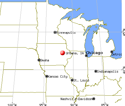
Nearest city with pop. 50,000+: Cedar Rapids, IA  (19.8 miles , pop. 120,758).
Nearest city with pop. 200,000+: Madison, WI (139.3 miles , pop. 208,054).
Nearest city with pop. 1,000,000+: Chicago, IL (217.3 miles , pop. 2,896,016).
Nearest cities:
), ), ), ), Latitude: 42.22 N, Longitude: 91.88 W
Area code: 319

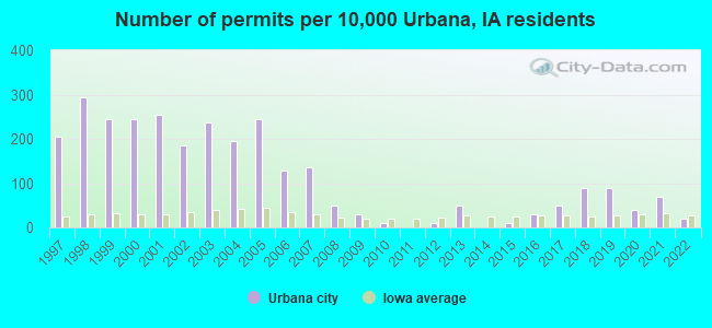
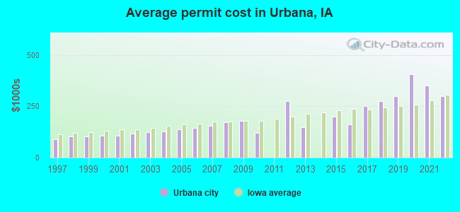
Single-family new house construction building permits:
- 2022: 2 buildings, average cost: $300,000
- 2021: 7 buildings, average cost: $350,000
- 2020: 4 buildings, average cost: $406,300
- 2019: 9 buildings, average cost: $300,000
- 2018: 9 buildings, average cost: $275,000
- 2017: 5 buildings, average cost: $250,000
- 2016: 3 buildings, average cost: $160,000
- 2015: 1 building, cost: $200,000
- 2013: 5 buildings, average cost: $146,500
- 2012: 1 building, cost: $275,000
- 2010: 1 building, cost: $120,000
- 2009: 3 buildings, average cost: $180,000
- 2008: 5 buildings, average cost: $173,300
- 2007: 14 buildings, average cost: $154,300
- 2006: 13 buildings, average cost: $143,900
- 2005: 25 buildings, average cost: $136,700
- 2004: 20 buildings, average cost: $128,700
- 2003: 24 buildings, average cost: $122,900
- 2002: 19 buildings, average cost: $116,300
- 2001: 26 buildings, average cost: $108,200
- 2000: 25 buildings, average cost: $108,200
- 1999: 25 buildings, average cost: $101,700
- 1998: 30 buildings, average cost: $101,700
- 1997: 21 buildings, average cost: $90,300
| Here: | 3.2% |
| Iowa: | 2.7% |
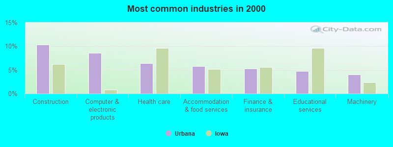
- Construction (10.4%)
- Computer & electronic products (8.6%)
- Health care (6.4%)
- Accommodation & food services (5.8%)
- Finance & insurance (5.3%)
- Educational services (4.7%)
- Machinery (4.0%)

- Construction (18.9%)
- Computer & electronic products (9.3%)
- Food (6.6%)
- Machinery (6.6%)
- Accommodation & food services (4.3%)
- Metal & metal products (4.0%)
- Administrative & support & waste management services (3.3%)
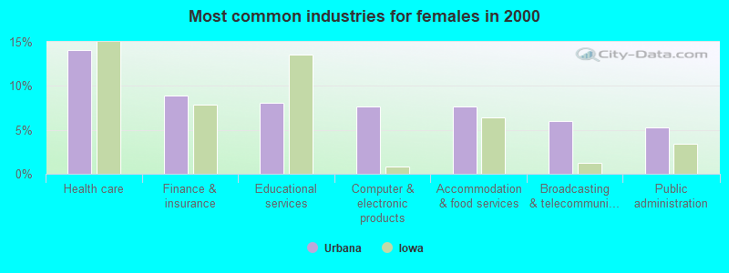
- Health care (14.1%)
- Finance & insurance (8.9%)
- Educational services (8.1%)
- Computer & electronic products (7.7%)
- Accommodation & food services (7.7%)
- Broadcasting & telecommunications (6.0%)
- Public administration (5.2%)
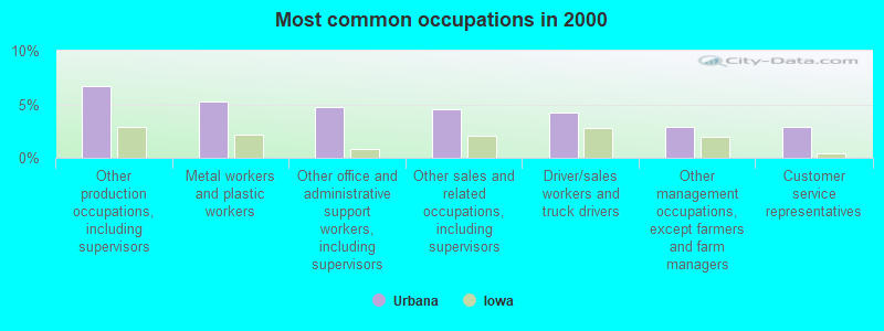
- Other production occupations, including supervisors (6.7%)
- Metal workers and plastic workers (5.3%)
- Other office and administrative support workers, including supervisors (4.7%)
- Other sales and related occupations, including supervisors (4.6%)
- Driver/sales workers and truck drivers (4.2%)
- Other management occupations, except farmers and farm managers (2.9%)
- Customer service representatives (2.9%)
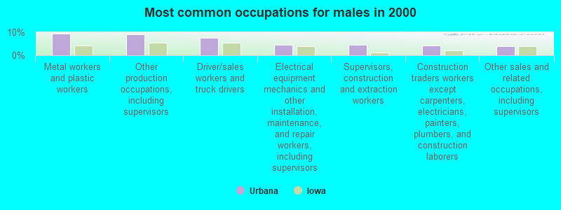
- Metal workers and plastic workers (9.3%)
- Other production occupations, including supervisors (9.0%)
- Driver/sales workers and truck drivers (7.6%)
- Electrical equipment mechanics and other installation, maintenance, and repair workers, including supervisors (4.7%)
- Supervisors, construction and extraction workers (4.7%)
- Construction traders workers except carpenters, electricians, painters, plumbers, and construction laborers (4.3%)
- Other sales and related occupations, including supervisors (4.0%)
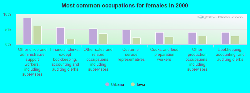
- Other office and administrative support workers, including supervisors (8.9%)
- Financial clerks, except bookkeeping, accounting and auditing clerks (5.6%)
- Other sales and related occupations, including supervisors (5.2%)
- Customer service representatives (4.8%)
- Cooks and food preparation workers (4.0%)
- Other production occupations, including supervisors (4.0%)
- Bookkeeping, accounting, and auditing clerks (4.0%)
Average climate in Urbana, Iowa
Based on data reported by over 4,000 weather stations


|
|


(lower is better)
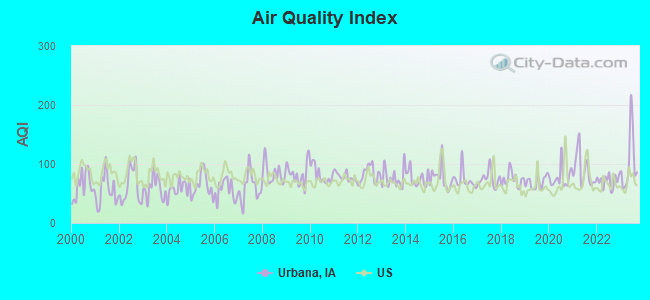
Air Quality Index (AQI) level in 2023 was 103. This is significantly worse than average.
| City: | 103 |
| U.S.: | 73 |
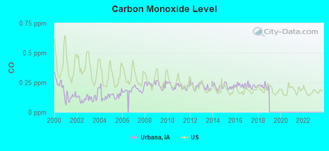
Carbon Monoxide (CO) [ppm] level in 2018 was 0.217. This is about average. Closest monitor was 19.5 miles away from the city center.
| City: | 0.217 |
| U.S.: | 0.251 |
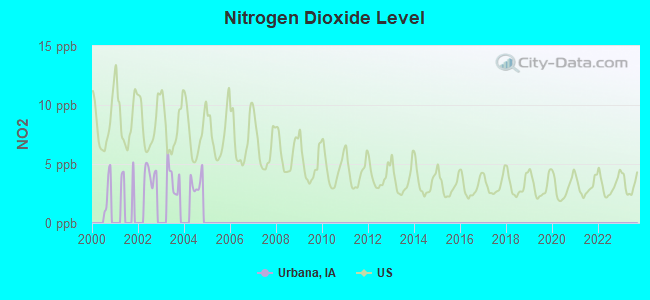
Nitrogen Dioxide (NO2) [ppb] level in 2004 was 3.43. This is significantly better than average. Closest monitor was 17.9 miles away from the city center.
| City: | 3.43 |
| U.S.: | 5.11 |
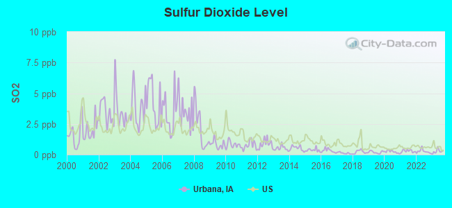
Sulfur Dioxide (SO2) [ppb] level in 2023 was 0.268. This is significantly better than average. Closest monitor was 17.1 miles away from the city center.
| City: | 0.268 |
| U.S.: | 1.515 |
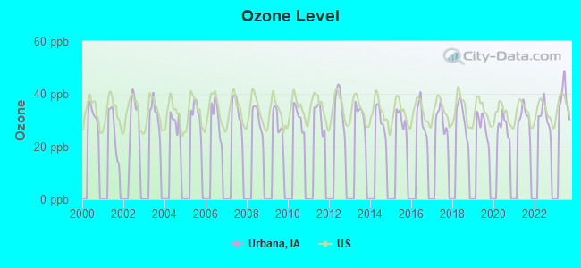
Ozone [ppb] level in 2023 was 38.0. This is about average. Closest monitor was 17.1 miles away from the city center.
| City: | 38.0 |
| U.S.: | 33.3 |
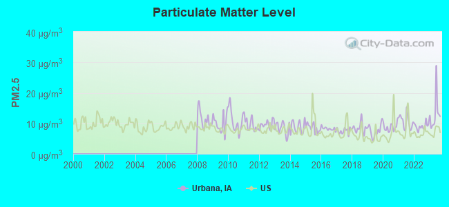
Particulate Matter (PM2.5) [µg/m3] level in 2023 was 13.2. This is significantly worse than average. Closest monitor was 18.3 miles away from the city center.
| City: | 13.2 |
| U.S.: | 8.1 |
Tornado activity:
Urbana-area historical tornado activity is near Iowa state average. It is 103% greater than the overall U.S. average.
On 4/30/1954, a category F4 (max. wind speeds 207-260 mph) tornado 10.8 miles away from the Urbana city center .
On 8/26/1965, a category F4 tornado 11.5 miles away from the city center killed one person and injured 17 people and caused between $500,000 and $5,000,000 in damages.
Earthquake activity:
Urbana-area historical earthquake activity is significantly above Iowa state average. It is 130% greater than the overall U.S. average.On 4/18/2008 at 09:36:59, a magnitude 5.4 (5.1 MB, 4.8 MS, 5.4 MW, 5.2 MW, Class: Moderate, Intensity: VI - VII) earthquake occurred 335.1 miles away from the city center
On 6/10/1987 at 23:48:54, a magnitude 5.1 (4.9 MB, 4.4 MS, 4.6 MS, 5.1 LG) earthquake occurred 315.3 miles away from the city center
On 4/18/2008 at 09:36:59, a magnitude 5.2 (5.2 MW, Depth: 8.9 mi) earthquake occurred 335.2 miles away from the city center
On 6/28/2004 at 06:10:52, a magnitude 4.2 (4.2 MW, Depth: 6.2 mi, Class: Light, Intensity: IV - V) earthquake occurred 162.3 miles away from the city center
On 9/3/2016 at 12:02:44, a magnitude 5.8 (5.8 MW, Depth: 3.5 mi) earthquake occurred 483.5 miles away from Urbana center
On 6/18/2002 at 17:37:15, a magnitude 5.0 (4.3 MB, 4.6 MW, 5.0 LG) earthquake occurred 364.4 miles away from the city center
Magnitude types: regional Lg-wave magnitude (LG), body-wave magnitude (MB), surface-wave magnitude (MS), moment magnitude (MW)
Natural disasters:
The number of natural disasters in Benton County (17) is near the US average (15).Major Disasters (Presidential) Declared: 15
Emergencies Declared: 1
Causes of natural disasters: Floods: 13, Storms: 11, Tornadoes: 5, Heavy Rain: 1, Hurricane: 1, Wind: 1, Winter Storm: 1, Other: 1 (Note: some incidents may be assigned to more than one category).

Hospitals and medical centers near Urbana:
- MERCY DIALYSIS - VINTON (Dialysis Facility, about 8 miles away; VINTON, IA)
- LUTHERAN HOME HEALTH AGENCY (Home Health Center, about 9 miles away; VINTON, IA)
- GENTIVA HEALTH SERVICES (Home Health Center, about 16 miles away; HIAWATHA, IA)
- HIAWATHA CARE CENTER (Nursing Home, about 16 miles away; HIAWATHA, IA)
Operable nuclear power plant near Urbana:
- 13 miles: Duane Arnold in Palo, IA.
Colleges/universities with over 2000 students nearest to Urbana:
- Kirkwood Community College (about 25 miles; Cedar Rapids, IA; Full-time enrollment: 11,503)
- Hawkeye Community College (about 28 miles; Waterloo, IA; FT enrollment: 7,160)
- University of Northern Iowa (about 36 miles; Cedar Falls, IA; FT enrollment: 10,816)
- University of Iowa (about 43 miles; Iowa City, IA; FT enrollment: 24,735)
- Upper Iowa University (about 43 miles; Fayette, IA; FT enrollment: 5,275)
- Northeast Iowa Community College-Calmar (about 66 miles; Calmar, IA; FT enrollment: 3,365)
- Luther College (about 76 miles; Decorah, IA; FT enrollment: 2,700)
Points of interest:
Notable locations in Urbana: Urbana Town Hall (A), Urbana Police Department (B). Display/hide their locations on the map
Churches in Urbana include: Urbana Catholic Church (A), Christian Church (B), United Methodist Church (C). Display/hide their locations on the map
Hotel: Super 8 Urbana IA (5369 Hutton Drive).
| This city: | 2.8 people |
| Iowa: | 2.4 people |
| This city: | 79.2% |
| Whole state: | 64.7% |
| This city: | 7.9% |
| Whole state: | 6.7% |
Likely homosexual households (counted as self-reported same-sex unmarried-partner households)
- Lesbian couples: 0.2% of all households
- Gay men: 0.4% of all households
Banks with branches in Urbana (2011 data):
- Wells Fargo Bank, National Association: Urbana Branch at 320 West Wood Street, branch established on 1901/01/01. Info updated 2011/04/05: Bank assets: $1,161,490.0 mil, Deposits: $905,653.0 mil, headquarters in Sioux Falls, SD, positive income, 6395 total offices, Holding Company: Wells Fargo & Company
- Security State Bank: Urbana Branch at 205 North Union Avenue, branch established on 2002/09/09. Info updated 2006/11/03: Bank assets: $94.5 mil, Deposits: $75.8 mil, headquarters in Independence, IA, positive income, Agricultural Specialization, 3 total offices, Holding Company: Independence Bancshares, Inc.
For population 15 years and over in Urbana:
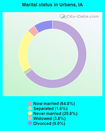
- Never married: 20.8%
- Now married: 64.8%
- Separated: 1.6%
- Widowed: 3.8%
- Divorced: 9.0%
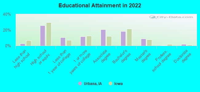
For population 25 years and over in Urbana:
- High school or higher: 97.0%
- Bachelor's degree or higher: 27.2%
- Graduate or professional degree: 10.0%
- Unemployed: 2.0%
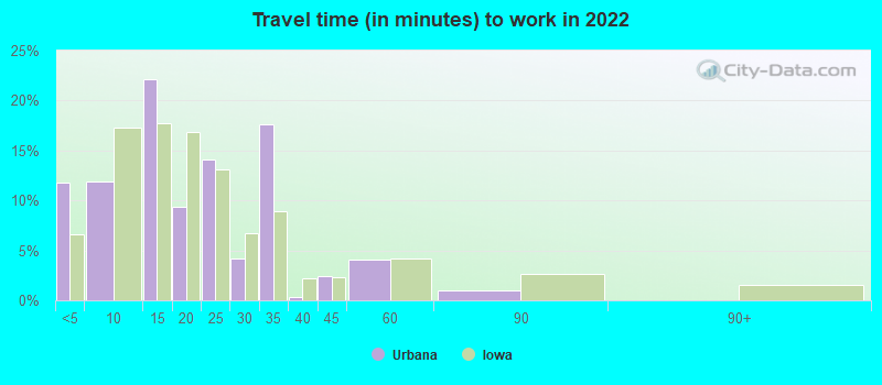
- Mean travel time to work (commute): 24.5 minutes
| Here: | 8.4 |
| Iowa average: | 10.5 |
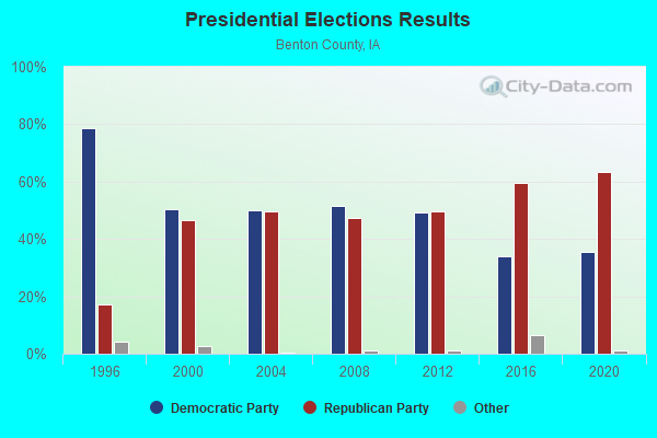
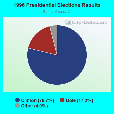
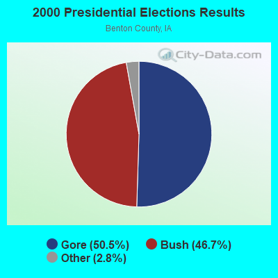
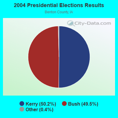
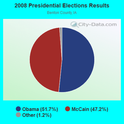
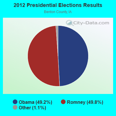
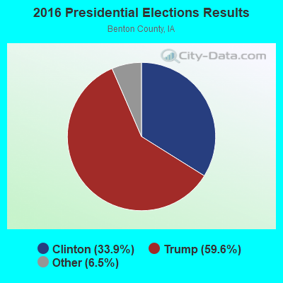
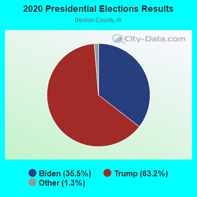
Graphs represent county-level data. Detailed 2008 Election Results
Religion statistics for Urbana, IA (based on Benton County data)
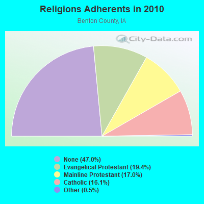
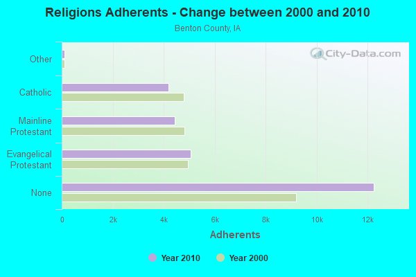
| Religion | Adherents | Congregations |
|---|---|---|
| Evangelical Protestant | 5,070 | 19 |
| Mainline Protestant | 4,433 | 21 |
| Catholic | 4,201 | 8 |
| Other | 120 | 3 |
| None | 12,252 | - |
Food Environment Statistics:
| This county: | 1.89 / 10,000 pop. |
| Iowa: | 2.14 / 10,000 pop. |
| This county: | 1.89 / 10,000 pop. |
| Iowa: | 0.43 / 10,000 pop. |
| Benton County: | 3.02 / 10,000 pop. |
| Iowa: | 5.55 / 10,000 pop. |
| Here: | 4.53 / 10,000 pop. |
| Iowa: | 8.01 / 10,000 pop. |
| Here: | 7.0% |
| Iowa: | 7.8% |
| This county: | 27.9% |
| Iowa: | 27.3% |
| Benton County: | 16.1% |
| Iowa: | 14.5% |
Health and Nutrition:
| Urbana: | 58.5% |
| Iowa: | 49.5% |
| Here: | 61.6% |
| State: | 46.1% |
| Urbana: | 27.5 |
| Iowa: | 28.6 |
| Urbana: | 16.9% |
| Iowa: | 21.4% |
| Here: | 6.8 |
| Iowa: | 6.8 |
| Urbana: | 29.0% |
| Iowa: | 33.8% |
| Urbana: | 67.9% |
| Iowa: | 55.9% |
| Urbana: | 82.8% |
| Iowa: | 77.7% |
More about Health and Nutrition of Urbana, IA Residents
| Local government employment and payroll (March 2022) | |||||
| Function | Full-time employees | Monthly full-time payroll | Average yearly full-time wage | Part-time employees | Monthly part-time payroll |
|---|---|---|---|---|---|
| Other Government Administration | 6 | $30,768 | $61,536 | 0 | $0 |
| Sewerage | 1 | $2,094 | $25,128 | 0 | $0 |
| Police Protection - Officers | 1 | $5,199 | $62,388 | 3 | $5,049 |
| Parks and Recreation | 1 | $1,739 | $20,868 | 0 | $0 |
| Streets and Highways | 1 | $2,657 | $31,884 | 0 | $0 |
| Financial Administration | 1 | $5,461 | $65,532 | 0 | $0 |
| Other and Unallocable | 0 | $0 | 1 | $68 | |
| Water Supply | 0 | $0 | 1 | $689 | |
| Totals for Government | 11 | $47,918 | $52,274 | 5 | $5,806 |
Urbana government finances - Expenditure in 2021 (per resident):
- Construction - Regular Highways: $1,741,000 ($1078.69)
- Current Operations - Regular Highways: $328,000 ($203.22)
Sewerage: $271,000 ($167.91)
Water Utilities: $266,000 ($164.81)
Police Protection: $205,000 ($127.01)
Solid Waste Management: $139,000 ($86.12)
Parks and Recreation: $113,000 ($70.01)
Local Fire Protection: $62,000 ($38.41)
General Public Buildings: $59,000 ($36.56)
Financial Administration: $47,000 ($29.12)
Libraries: $41,000 ($25.40)
General - Other: $23,000 ($14.25)
Central Staff Services: $21,000 ($13.01)
Judicial and Legal Services: $18,000 ($11.15)
Protective Inspection and Regulation - Other: $9,000 ($5.58)
Public Welfare - Other: $2,000 ($1.24)
- General - Interest on Debt: $72,000 ($44.61)
- Intergovernmental to Local - Other - General - Other: $62,000 ($38.41)
Other - Libraries: $11,000 ($6.82)
Other - Police Protection: $3,000 ($1.86)
- Total Salaries and Wages: $407,000 ($252.17)
Urbana government finances - Revenue in 2021 (per resident):
- Charges - Sewerage: $542,000 ($335.81)
Solid Waste Management: $154,000 ($95.42)
- Federal Intergovernmental - Other: $36,000 ($22.30)
- Local Intergovernmental - Other: $10,000 ($6.20)
- Miscellaneous - Interest Earnings: $9,000 ($5.58)
Fines and Forfeits: $8,000 ($4.96)
General Revenue - Other: $2,000 ($1.24)
Rents: $1,000 ($0.62)
- Revenue - Water Utilities: $295,000 ($182.78)
- State Intergovernmental - Highways: $411,000 ($254.65)
- Tax - Property: $1,151,000 ($713.14)
General Sales and Gross Receipts: $128,000 ($79.31)
Other License: $47,000 ($29.12)
Urbana government finances - Debt in 2021 (per resident):
- Long Term Debt - Outstanding Unspecified Public Purpose: $3,227,000 ($1999.38)
Beginning Outstanding - Unspecified Public Purpose: $2,352,000 ($1457.25)
Issue, Unspecified Public Purpose: $1,450,000 ($898.39)
Retired Unspecified Public Purpose: $575,000 ($356.26)
Urbana government finances - Cash and Securities in 2021 (per resident):
- Other Funds - Cash and Securities: $2,510,000 ($1555.14)
Strongest AM radio stations in Urbana:
- KXEL (1540 AM; 50 kW; WATERLOO, IA; Owner: KXEL BROADCASTING COMPANY, INC.)
- WMT (600 AM; 5 kW; CEDAR RAPIDS, IA; Owner: CITICASTERS LICENSES, L.P.)
- WHO (1040 AM; 50 kW; DES MOINES, IA; Owner: CITICASTERS LICENSES, L.P.)
- KDNZ (1650 AM; 10 kW; CEDAR FALLS, IA; Owner: FIFE COMMUNICATIONS CO., LLC)
- KKHQ (950 AM; 5 kW; OELWEIN, IA; Owner: CUMULUS LICENSING CORP.)
- KWLO (1330 AM; 5 kW; WATERLOO, IA; Owner: KXEL BROADCASTING COMPANY, INC.)
- KCNZ (1250 AM; 10 kW; CEDAR FALLS, IA; Owner: FIFE COMMUNICATION COMPANY, L.C.)
- KCRG (1600 AM; 5 kW; CEDAR RAPIDS, IA; Owner: CEDAR RAPIDS TELEVISION CO.)
- KCJJ (1630 AM; 10 kW; IOWA CITY, IA; Owner: RIVER CITY RADIO, INC.)
- KMRY (1450 AM; 1 kW; CEDAR RAPIDS, IA; Owner: SELLERS BROADCASTING, INC.)
- WSUI (910 AM; 5 kW; IOWA CITY, IA; Owner: THE UNIVERSITY OF IOWA)
- WTMJ (620 AM; 50 kW; MILWAUKEE, WI; Owner: JOURNAL BROADCAST CORPORATION)
- WSCR (670 AM; 50 kW; CHICAGO, IL; Owner: INFINITY BROADCASTING OPERATIONS, INC.)
Strongest FM radio stations in Urbana:
- KUNI (90.9 FM; CEDAR FALLS, IA; Owner: UNIVERSITY OF NORTHERN IOWA)
- KFMW (107.9 FM; WATERLOO, IA; Owner: KXEL BROADCASTING COMPANY, INC.)
- KDAT (104.5 FM; CEDAR RAPIDS, IA; Owner: CUMULUS LICENSING CORP.)
- KOKZ (105.7 FM; WATERLOO, IA; Owner: KXEL BROADCASTING COMPANY, INC.)
- KZIA (102.9 FM; CEDAR RAPIDS, IA; Owner: KZIA, INC.)
- KNWS-FM (101.9 FM; WATERLOO, IA; Owner: NORTHWESTERN COLLEGE)
- KOEL-FM (92.3 FM; OELWEIN, IA; Owner: CUMULUS LICENSING CORP.)
- WMT-FM (96.5 FM; CEDAR RAPIDS, IA; Owner: CITICASTERS LICENSES, L.P.)
- KRNA (94.1 FM; IOWA CITY, IA; Owner: CUMULUS LICENSING CORP.)
- KQMG-FM (95.3 FM; INDEPENDENCE, IA; Owner: KEENE OF IOWA, INC.)
- KSUI (91.7 FM; IOWA CITY, IA; Owner: THE UNIVERSITY OF IOWA)
- KHAK (98.1 FM; CEDAR RAPIDS, IA; Owner: CUMULUS LICENSING CORP.)
- KCCK-FM (88.3 FM; CEDAR RAPIDS, IA; Owner: KIRKWOOD COMMUNITY COLLEGE)
- KHKE (89.5 FM; CEDAR FALLS, IA; Owner: UNIVERSITY OF NORTHERN IOWA)
TV broadcast stations around Urbana:
- KGAN (Channel 2; CEDAR RAPIDS, IA; Owner: KGAN LICENSEE, LLC)
- KCRG-TV (Channel 9; CEDAR RAPIDS, IA; Owner: CEDAR RAPIDS TELEVISION CO.)
- KRIN (Channel 32; WATERLOO, IA; Owner: IOWA PUBLIC BROADCASTING BOARD)
- KPXR (Channel 48; CEDAR RAPIDS, IA; Owner: PAXSON COMMUNICATIONS LICENSE COMPANY, LLC)
- KWWL (Channel 7; WATERLOO, IA; Owner: RAYCOM AMERICA, INC.)
- KFXA (Channel 28; CEDAR RAPIDS, IA; Owner: SECOND GENERATION OF IOWA, LTD.)
- K17ET (Channel 17; CEDAR RAPIDS, IA; Owner: TRINITY BROADCASTING NETWORK)
- KWKB (Channel 20; IOWA CITY, IA; Owner: KM TELEVISION OF IOWA, L.L.C.)
- KIIN (Channel 12; IOWA CITY, IA; Owner: IOWA PUBLIC BROADCASTING BOARD)
Urbana fatal accident list:
Oct 29, 2004 10:16 PM, Sr-150, 55th St, Lat: 42.225587, Lon: -91.894822, Vehicles: 2, Persons: 3, Fatalities: 1, Drunk persons involved: 1
Aug 6, 2000 04:30 PM, Sr-363, Vehicles: 2, Persons: 3, Fatalities: 1
Dec 13, 1988 06:05 PM, Union St., Vehicles: 1, Persons: 2, Fatalities: 1
- National Bridge Inventory (NBI) Statistics
- 31Number of bridges
- 358ft / 109mTotal length
- 87,660Total average daily traffic
- 23,452Total average daily truck traffic
- New bridges - historical statistics
- 11940-1949
- 21960-1969
- 31970-1979
- 161980-1989
- 31990-1999
- 32000-2009
- 22010-2019
- 12020-2022
FCC Registered Cell Phone Towers:
1 (See the full list of FCC Registered Cell Phone Towers in Urbana)FCC Registered Antenna Towers:
21 (See the full list of FCC Registered Antenna Towers)FCC Registered Commercial Land Mobile Towers:
1- Lat: 42.294167 Lon: -91.886278, Call Sign: KAJ318,
Assigned Frequencies: 26.0900 MHz, 26.4700 MHz, Grant Date: 06/30/2000, Expiration Date: 02/01/2029, Registrant: Iheartmedia, Inc., 7136 S. Yale Avenue, Suite 501, Tulsa, OK 74136, Phone: (918) 664-4581, Fax: (918) 664-3066, Email:
FCC Registered Broadcast Land Mobile Towers:
1- Hwy 363 (Lat: 42.223333 Lon: -91.872389), Call Sign: KNEA267,
Assigned Frequencies: 154.280 MHz, 154.400 MHz, 154.430 MHz, Grant Date: 10/13/2012, Expiration Date: 11/30/2022, Cancellation Date: 02/04/2023, Registrant: Radio Communications Company, Inc., 2131 North Towne Lane Ne, Cedar Rapids, IA 52402, Phone: (319) 393-7150, Fax: (319) 393-9273, Email:
FCC Registered Microwave Towers:
6- URBANA, 3/4 Of Mile West Of Iintersection Of 32nd Street & Hwy 363 (Lat: 42.232083 Lon: -91.871472), Type: Gtower, Structure height: 54.8 m, Overall height: 59.4 m, Call Sign: WPSK464,
Assigned Frequencies: 6271.36 MHz, Grant Date: 04/27/2021, Expiration Date: 05/31/2031, Certifier: Steven T Campbell, Registrant: Wilkinson Barker Knauer, LLP, 1800 M Street Nw, Suite 800n, Washington, DC 20036, Phone: (202) 383-3420, Fax: (202) 783-5851, Email:
- URBANA, Lat: 42.223111 Lon: -91.876000, Call Sign: WQFF872,
Assigned Frequencies: 956.331 MHz, Grant Date: 05/07/2016, Expiration Date: 07/06/2026, Certifier: Charles Eldred, Registrant: Sensus, 450 N Gallatin Ave, Uniontown, PA 15401, Phone: (800) 638-3748, Fax: (800) 888-2403, Email:
- URBANA, 3287 55th Street Trail (Lat: 42.218028 Lon: -91.854028), Type: Ltower, Structure height: 57.9 m, Overall height: 60.7 m, Call Sign: WQSU498,
Assigned Frequencies: 6315.84 MHz, 6345.49 MHz, 6375.14 MHz, 6404.79 MHz, Grant Date: 11/18/2013, Expiration Date: 11/18/2023, Cancellation Date: 06/05/2023, Certifier: John Monday, Registrant: At&t Services, Inc., 208 S. Akard St. 20f, Dallas, TX 75202, Phone: (855) 699-7073, Email:
- BENTON, 5397 31st Ave. (Lat: 42.238472 Lon: -91.891722), Type: Ltower, Structure height: 91.4 m, Call Sign: WRCG660, Licensee ID: L00026454,
Assigned Frequencies: 5945.20 MHz, 6034.15 MHz, Grant Date: 09/26/2018, Expiration Date: 09/26/2028, Certifier: Heath Hove, Registrant: State Of Iowa, 215 East 7th St, Des Moines, IA 50319, Phone: (515) 725-6234, Email:
- 4.75 Mi N Of Urbana (Lat: 42.294139 Lon: -91.886278), Structure height: 76.2 m, Call Sign: KDD22,
Assigned Frequencies: 6950.00 MHz, Grant Date: 01/30/1968, Expiration Date: 02/01/1983, Cancellation Date: 06/11/2000, Registrant: Lee Enterprises Inc, 130 East Second St, Davenport, IA 52801
- 4.7 Mi N Of (Lat: 42.295250 Lon: -91.886278), Structure height: 413 m, Overall height: 413.3 m, Call Sign: WGR817,
Assigned Frequencies: 6950.00 MHz, Grant Date: 04/07/1980, Expiration Date: 02/01/2022, Registrant: Pillsbury Winthrop Shaw Pittman, LLP, 1200 Seventeenth Street, Nw, Washington, DC 20036, Phone: (202) 663-8195, Fax: (202) 663-8007, Email:
FCC Registered Amateur Radio Licenses:
8 (See the full list of FCC Registered Amateur Radio Licenses in Urbana)FAA Registered Aircraft:
1- Aircraft: PIPER PA-28-151 (Category: Land, Seats: 4, Weight: Up to 12,499 Pounds, Speed: 80 mph), Engine: LYCOMING 0-320 SERIES (180 HP) (Reciprocating)
N-Number: 42671, N42671, N-42671, Serial Number: 28-7415398, Year manufactured: 1974, Airworthiness Date: 04/08/1974, Certificate Issue Date: 03/11/2020
Registrant (Individual): Garry M Jensen, 300 E Main St, Urbana, IA 52345
2002 - 2018 National Fire Incident Reporting System (NFIRS) incidents
- Fire incident types reported to NFIRS in Urbana, IA
- 12658.9%Outside Fires
- 4822.4%Mobile Property/Vehicle Fires
- 3516.4%Structure Fires
- 52.3%Other
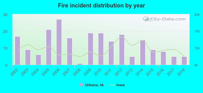 Based on the data from the years 2002 - 2018 the average number of fires per year is 13. The highest number of reported fire incidents - 27 took place in 2006, and the least - 1 in 2008. The data has a dropping trend.
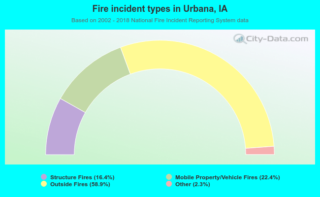 When looking into fire subcategories, the most reports belonged to: Outside Fires (58.9%), and Mobile Property/Vehicle Fires (22.4%).
| Most common first names in Urbana, IA among deceased individuals | ||
| Name | Count | Lived (average) |
|---|---|---|
| John | 6 | 78.2 years |
| George | 5 | 81.6 years |
| William | 5 | 68.4 years |
| Dorothy | 4 | 76.5 years |
| Alice | 4 | 86.3 years |
| Harold | 4 | 71.3 years |
| Mary | 4 | 87.2 years |
| Harry | 3 | 86.6 years |
| Donald | 3 | 80.6 years |
| Clarence | 3 | 79.7 years |
| Most common last names in Urbana, IA among deceased individuals | ||
| Last name | Count | Lived (average) |
|---|---|---|
| Kramer | 10 | 77.7 years |
| Smith | 8 | 77.3 years |
| Hepker | 6 | 82.8 years |
| Ferguson | 6 | 80.5 years |
| Cook | 4 | 81.7 years |
| Boyles | 4 | 75.2 years |
| Kisling | 4 | 82.5 years |
| Dripps | 4 | 78.2 years |
| Zieser | 4 | 86.8 years |
| Strait | 4 | 71.2 years |
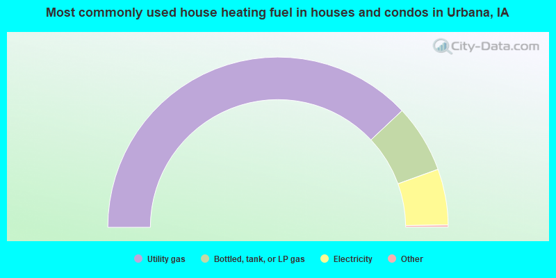
- 76.3%Utility gas
- 13.0%Bottled, tank, or LP gas
- 10.7%Electricity
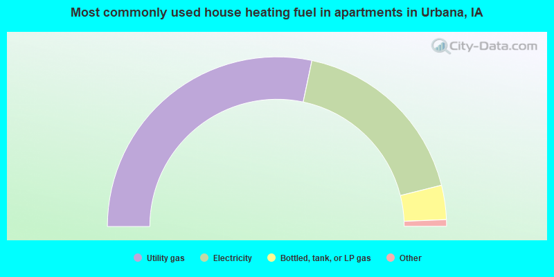
- 57.4%Utility gas
- 36.1%Electricity
- 6.6%Bottled, tank, or LP gas
Urbana compared to Iowa state average:
- Median household income above state average.
- Unemployed percentage significantly below state average.
- Black race population percentage below state average.
- Median age significantly below state average.
- Foreign-born population percentage significantly below state average.
- Renting percentage significantly below state average.
- House age below state average.

|
Total of 6 patent applications in 2008-2024.