Verona Island, Maine
Submit your own pictures of this town and show them to the world
- OSM Map
- Google Map
- MSN Map
| Males: 270 | |
| Females: 274 |
| Median resident age: | 47.3 years |
| Maine median age: | 43.0 years |
| Verona Island: | $70,956 |
| ME: | $69,543 |
Estimated per capita income in 2022: $45,044
Verona Island town income, earnings, and wages data
Estimated median house or condo value in 2022: $328,112
| Verona Island: | $328,112 |
| ME: | $290,600 |
Mean prices in 2022: all housing units: $415,956; detached houses: $442,502; townhouses or other attached units: $442,441; in 2-unit structures: $393,150; in 3-to-4-unit structures: $266,359; in 5-or-more-unit structures: $407,319; mobile homes: $150,042; occupied boats, rvs, vans, etc.: $76,651
Detailed information about poverty and poor residents in Verona Island, ME


- 53097.4%White alone
- 112.0%Two or more races
- 20.4%Hispanic
- 10.2%American Indian alone

 Recent articles from our blog. Our writers, many of them Ph.D. graduates or candidates, create easy-to-read articles on a wide variety of topics.
Current Local Time: EST time zone
Nearest city with pop. 50,000+: Portland, ME  (95.3 miles , pop. 64,249).
Nearest city with pop. 200,000+: Boston, MA (192.1 miles , pop. 589,141).
Nearest city with pop. 1,000,000+: Bronx, NY (363.4 miles , pop. 1,332,650).
Nearest cities:
), ), ), )Latitude: 44.54 N, Longitude: 68.78 W
Area code commonly used in this area: 207
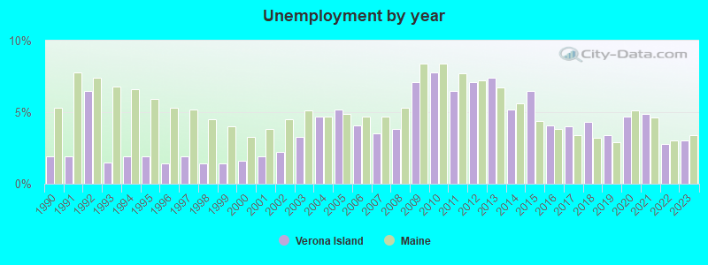
| Here: | 3.0% |
| Maine: | 3.4% |
(lower is better)

Air Quality Index (AQI) level in 2023 was 61.1. This is about average.
| City: | 61.1 |
| U.S.: | 72.6 |

Ozone [ppb] level in 2023 was 33.6. This is about average. Closest monitor was 7.9 miles away from the city center.
| City: | 33.6 |
| U.S.: | 33.3 |

Particulate Matter (PM2.5) [µg/m3] level in 2023 was 5.62. This is significantly better than average. Closest monitor was 18.2 miles away from the city center.
| City: | 5.62 |
| U.S.: | 8.11 |
Earthquake activity:
Verona Island-area historical earthquake activity is significantly above Maine state average. It is 79% smaller than the overall U.S. average.On 10/16/2012 at 23:12:25, a magnitude 4.7 (4.7 ML, Depth: 10.0 mi, Class: Light, Intensity: IV - V) earthquake occurred 113.6 miles away from Verona Island center
On 4/20/2002 at 10:50:47, a magnitude 5.3 (5.3 ML, Depth: 3.0 mi, Class: Moderate, Intensity: VI - VII) earthquake occurred 242.4 miles away from Verona Island center
On 4/20/2002 at 10:50:47, a magnitude 5.2 (5.2 MB, 4.2 MS, 5.2 MW, 5.0 MW) earthquake occurred 243.5 miles away from the city center
On 1/19/1982 at 00:14:42, a magnitude 4.7 (4.5 MB, 4.7 MD, 4.5 LG) earthquake occurred 157.5 miles away from the city center
On 10/7/1983 at 10:18:46, a magnitude 5.3 (5.1 MB, 5.3 LG, 5.1 ML) earthquake occurred 278.4 miles away from Verona Island center
On 2/26/1999 at 03:38:43, a magnitude 3.8 (3.8 LG, Depth: 2.0 mi, Class: Light, Intensity: II - III) earthquake occurred 36.7 miles away from Verona Island center
Magnitude types: regional Lg-wave magnitude (LG), body-wave magnitude (MB), duration magnitude (MD), local magnitude (ML), surface-wave magnitude (MS), moment magnitude (MW)
Natural disasters:
The number of natural disasters in Lincoln County (24) is greater than the US average (15).Major Disasters (Presidential) Declared: 19
Emergencies Declared: 4
Causes of natural disasters: Floods: 15, Storms: 11, Winter Storms: 4, Hurricanes: 2, Snows: 2, Winds: 2, Blizzard: 1, Heavy Rain: 1, Ice Storm: 1, Landslide: 1, Snowfall: 1, Tropical Storm: 1, Other: 2 (Note: some incidents may be assigned to more than one category).
Hospitals and medical centers near Verona Island:
- HARBOR HILL CENTER (Nursing Home, about 14 miles away; BELFAST, ME)
- BRADBURY MANOR (Nursing Home, about 14 miles away; BELFAST, ME)
- THE COMMONS AT TALL PINES (Nursing Home, about 14 miles away; BELFAST, ME)
- DIALYSIS CLINIC INC. - BELFAST (Dialysis Facility, about 14 miles away; BELFAST, ME)
- WALDO COUNTY GENERAL HOSPITAL Critical Access Hospitals (about 14 miles away; BELFAST, ME)
Colleges/universities with over 2000 students nearest to Verona Island:
- Husson University (about 21 miles; Bangor, ME; Full-time enrollment: 2,421)
- University of Maine (about 26 miles; Orono, ME; FT enrollment: 8,931)
- University of Maine at Augusta (about 52 miles; Augusta, ME; FT enrollment: 3,204)
- University of Maine at Farmington (about 68 miles; Farmington, ME; FT enrollment: 2,036)
- Southern Maine Community College (about 95 miles; South Portland, ME; FT enrollment: 4,666)
- University of Southern Maine (about 96 miles; Portland, ME; FT enrollment: 6,647)
- Saint Joseph's College of Maine (about 98 miles; Standish, ME; FT enrollment: 2,010)
| This town: | 2.3 people |
| Maine: | 2.3 people |
| This town: | 68.9% |
| Whole state: | 62.9% |
| This town: | 10.1% |
| Whole state: | 9.4% |
No gay or lesbian households reported
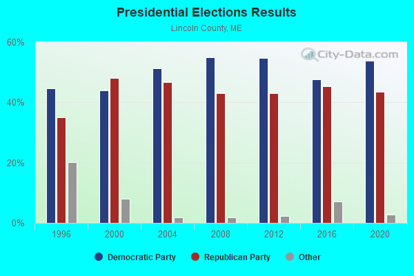
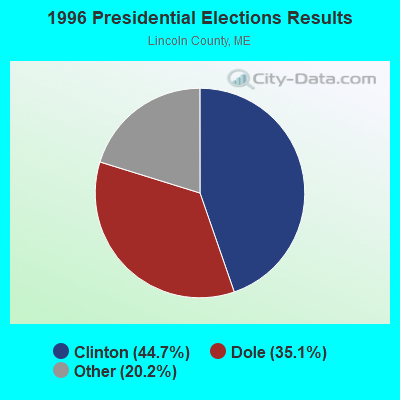
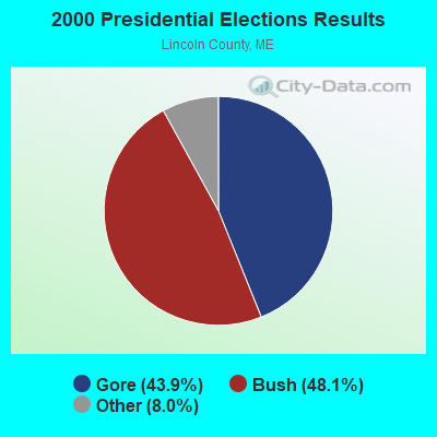


Graphs represent county-level data. Detailed 2008 Election Results
Religion statistics for Verona Island, ME (based on Lincoln County data)
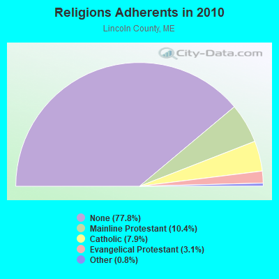

| Religion | Adherents | Congregations |
|---|---|---|
| Mainline Protestant | 3,586 | 29 |
| Catholic | 2,725 | 3 |
| Evangelical Protestant | 1,065 | 12 |
| Other | 279 | 4 |
| None | 26,802 | - |
Food Environment Statistics:
| Here: | 4.03 / 10,000 pop. |
| Maine: | 2.80 / 10,000 pop. |
| Here: | 2.59 / 10,000 pop. |
| Maine: | 2.20 / 10,000 pop. |
| Lincoln County: | 6.62 / 10,000 pop. |
| State: | 5.75 / 10,000 pop. |
| Lincoln County: | 13.23 / 10,000 pop. |
| Maine: | 11.02 / 10,000 pop. |
| Lincoln County: | 7.0% |
| Maine: | 8.2% |
| Lincoln County: | 21.9% |
| Maine: | 25.0% |
Strongest AM radio stations in Verona Island:
- WABI (910 AM; 5 kW; BANGOR, ME; Owner: CLEAR CHANNEL BROADCASTING LICENSES, INC.)
- WZON (620 AM; 5 kW; BANGOR, ME; Owner: THE ZONE CORPORATION)
- WDEA (1370 AM; 5 kW; ELLSWORTH, ME; Owner: CUMULUS LICENSING CORP.)
- WSKW (1160 AM; 10 kW; SKOWHEGAN, ME; Owner: MOUNTAIN WIRELESS, INCORPORATED)
- WRKO (680 AM; 50 kW; BOSTON, MA; Owner: ENTERCOM BOSTON LICENSE, LLC)
- WTME (780 AM; 10 kW; RUMFORD, ME; Owner: MOUNTAIN VALLEY BROADCASTING, INC.)
- WNZS (1340 AM; 1 kW; VEAZIE, ME; Owner: WATERFRONT COMMUNICATIONS INC.)
- WEEI (850 AM; 50 kW; BOSTON, MA; Owner: ENTERCOM BOSTON LICENSE, LLC)
- WBZ (1030 AM; 50 kW; BOSTON, MA; Owner: INFINITY BROADCASTING OPERATIONS, INC.)
- WFAU (1280 AM; 5 kW; GARDINER, ME; Owner: CAPSTAR TX LIMITED PARTNERSHIP)
- WCRN (830 AM; 50 kW; WORCESTER, MA; Owner: CARTER BROADCASTING CORPORATION)
- WNNZ (640 AM; 50 kW; WESTFIELD, MA; Owner: CLEAR CHANNEL BROADCASTING LICENSES, INC.)
- WMTW (870 AM; 10 kW; GORHAM, ME; Owner: RADIO PARTNERS OF MAINE, L.P.)
Strongest FM radio stations in Verona Island:
- WBFB (104.7 FM; BELFAST, ME; Owner: CLEAR CHANNEL BROADCASTING LICENSES, INC.)
- WFZX (101.7 FM; SEARSPORT, ME; Owner: CLEAR CHANNEL BROADCASTING LICENSES, INC.)
- WKIT-FM (100.3 FM; BREWER, ME; Owner: THE ZONE CORPORATION)
- WWMJ (95.7 FM; ELLSWORTH, ME; Owner: CUMULUS LICENSING CORP.)
- WERU-FM (89.9 FM; BLUE HILL, ME; Owner: SALT POND COMMUNITY B/C COMPANY)
- WWBX (97.1 FM; BANGOR, ME; Owner: CLEAR CHANNEL BROADCASTING LICENSES, INC.)
- WMEH (90.9 FM; BANGOR, ME; Owner: MAINE PUBLIC BROADCASTING CORPORATION)
- WEZQ (92.9 FM; BANGOR, ME; Owner: CUMULUS LICENSING CORP.)
- WMEP (90.5 FM; CAMDEN, ME; Owner: MAINE PUBLIC BROADCASTING CORP.)
- WQSS (102.5 FM; CAMDEN, ME; Owner: CLEAR CHANNEL BROADCASTING LICENSES, INC.)
- WHCF (88.5 FM; BANGOR, ME; Owner: BANGOR BAPTIST CHURCH)
- WVOM (103.9 FM; HOWLAND, ME; Owner: CLEAR CHANNEL BROADCASTING LICENSES, INC.)
- WNSX (97.7 FM; WINTER HARBOR, ME; Owner: CLEAR CHANNEL BROADCASTING LICENSES, INC.)
- WLKE (99.1 FM; BAR HARBOR, ME; Owner: CLEAR CHANNEL BROADCASTING LICENSES, INC.)
- WQCB (106.5 FM; BREWER, ME; Owner: CUMULUS LICENSING CORP.)
- WMCM (103.3 FM; ROCKLAND, ME; Owner: CLEAR CHANNEL BROADCASTING LICENSES, INC.)
- WBYA (105.5 FM; ISLESBORO, ME; Owner: MARINER BROADCASTING LIMTED PARTNERSHIP)
- WBQX (106.9 FM; THOMASTON, ME; Owner: MARINER BROADCASTING LIMITED PARTNER)
- WBZN (107.3 FM; OLD TOWN, ME; Owner: CUMULUS LICENSING CORP.)
TV broadcast stations around Verona Island:
- WCKD-LP (Channel 30; BANGOR/DEDHAM, ME; Owner: J. MCLEOD, ME FAMILY B/CING., INC.)
- WABI-TV (Channel 5; BANGOR, ME; Owner: COMMUNITY BROADCASTING SERVICE)
- WLBZ (Channel 2; BANGOR, ME; Owner: PACIFIC AND SOUTHERN COMPANY, INC.)
- WBGR-LP (Channel 33; BANGOR/DEDHAM, ME; Owner: MAINE FAMILY BROADCASTING, INC.)
- WMEB-TV (Channel 12; ORONO, ME; Owner: MAINE PUBLIC BROADCASTING CORPORATION)
- W36CK (Channel 36; BANGOR, ME; Owner: TRINITY BROADCASTING NETWORK)
- W66CL (Channel 66; BANGOR, ME; Owner: MS COMMUNICATIONS, LLC)
FCC Registered Antenna Towers:
7- Richard Houde, East Side Drive (Lat: 44.552944 Lon: -68.782333), Type: 59.7, Overall height: 57.9 m, Registrant: Holland & Knight LLP, Pconnolly@hklaw.Com, , Washi-ngton, Phone: (202) 862-5989
- Erik Brooks, East Side Drive (Lat: 44.552944 Lon: -68.782333), Type: 59.7, Overall height: 57.9 m, Registrant: Holland & Knight LLP, Pconnolly@hklaw.Com, , Washi-ngton, Phone: (202) 862-5989
- Cayla Gamble, East Side Drive (Lat: 44.552944 Lon: -68.782333), Type: 59.7, Structure height: 23009 m, Overall height: 57.9 m, Registrant: Holland & Knight LLP, Peter.Connolly@hklaw.Com, , Washi-ngton, Phone: (202) 862-5989
- Cayla Gamble, East Side Drive (Lat: 44.552944 Lon: -68.782333), Type: 59.7, Structure height: 23009 m, Overall height: 57.9 m, Registrant: Holland & Knight LLP, Peter.Connolly@hklaw.Com, , Washi-ngton, Phone: (202) 862-5989
- Cayla Gamble, East Side Drive (Lat: 44.552944 Lon: -68.782333), Type: 59.7, Structure height: 23009 m, Overall height: 57.9 m, Registrant: Holland & Knight LLP, Peter.Connolly@hklaw.Com, , Washi-ngton, Phone: (202) 862-5989
- Cayla Gamble, East Side Drive (Lat: 44.552944 Lon: -68.782333), Type: 59.7, Structure height: 23009 m, Overall height: 57.9 m, Registrant: Holland & Knight LLP, Peter.Connolly@hklaw.Com, , Washi-ngton, Phone: (202) 862-5989
- Cayla Gamble, East Side Drive (Lat: 44.552944 Lon: -68.782333), Type: 59.7, Structure height: 23009 m, Overall height: 57.9 m, Registrant: Wilkinson Barker Knauer, LLP, Gwerner@wbklaw.Com, , Washi-ngton, Phone: (202) 383-3420
FCC Registered Microwave Towers:
1- Verona Island, East Side Drive (Lat: 44.552944 Lon: -68.782333), Type: Ltower, Structure height: 57.9 m, Overall height: 59.7 m, Call Sign: WREW379,
Assigned Frequencies: 11485.0 MHz, 11485.0 MHz, 11485.0 MHz, 11485.0 MHz, 11485.0 MHz, 11485.0 MHz, 11485.0 MHz, 11485.0 MHz, Grant Date: 12/12/2019, Expiration Date: 12/12/2029, Certifier: Jim Mckenna, Registrant: Intelpath, Hinsdale, IL 60522, Phone: (312) 841-9188, Email:
FCC Registered Maritime Coast & Aviation Ground Towers:
1- Fire Road 17 (Lat: 44.564806 Lon: -68.776417), Type: Building, Overall height: 11 m, Call Sign: WQB337, Licensee ID: L00099082,
Assigned Frequencies: 156.350 MHz, 156.450 MHz, 156.800 MHz, Grant Date: 06/09/1997, Expiration Date: 06/09/2002, Cancellation Date: 09/08/2002, Registrant: Kirk C Plender, Rr 2 Fire Rd 17, Verona, ME 04416
FCC Registered Amateur Radio Licenses:
4- Call Sign: N1ZFH, Licensee ID: L01161162, Grant Date: 03/22/2017, Expiration Date: 05/16/2027, Certifier: Paul H Webster, Registrant: Paul H Webster, 249 E Side Drive, Verona Island, ME 04416-3400
- Call Sign: NW0W, Previous Call Sign: NN4DX, Licensee ID: L00183612, Grant Date: 06/13/2009, Expiration Date: 06/13/2019, Cancellation Date: 02/16/2018, Certifier: Timothy R Havens, Registrant: Timothy R Havens, 196 West Side Dr, Verona Island, ME 04416
- Call Sign: KO1DX, Previous Call Sign: NW0W, Licensee ID: L00183612, Grant Date: 02/16/2018, Expiration Date: 02/16/2028, Cancellation Date: 08/27/2019, Certifier: Timothy R Havens 370, Registrant: Timothy R Havens, 196 West Side Dr, Verona Island, ME 04416
- Call Sign: WW1L, Previous Call Sign: KO1DX, Licensee ID: L00183612, Grant Date: 08/27/2019, Expiration Date: 08/27/2029, Certifier: Timothy R Havens, Registrant: Timothy R Havens, 196 West Side Dr, Verona Island, ME 04416
FAA Registered Aircraft:
1- Aircraft: TAYLORCRAFT BC12-D (Category: Land, Seats: 2, Weight: Up to 12,499 Pounds, Speed: 78 mph), Engine: CONT MOTOR A&C65 SERIES (65 HP) (Reciprocating)
N-Number: 5110M, N5110M, N-5110M, Serial Number: 10410, Airworthiness Date: 09/19/1956, Certificate Issue Date: 02/14/2018
Registrant (Individual): Vaughn A Peters, 14 Admiral Perry Ln, Verona Island, ME 04416
Deregistered: Cancel Date: 05/31/2017
Verona Island compared to Maine state average:
- Unemployed percentage significantly below state average.
- Black race population percentage significantly below state average.
- Hispanic race population percentage significantly below state average.
- Median age above state average.
- Foreign-born population percentage significantly below state average.
- Renting percentage below state average.
- Length of stay since moving in significantly above state average.
- Number of rooms per house significantly below state average.
- House age significantly below state average.
- Number of college students significantly below state average.
- Percentage of population with a bachelor's degree or higher significantly below state average.