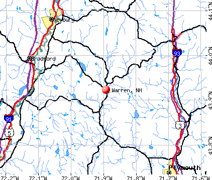
Warren, New Hampshire
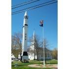
Warren: Warren NH Church Rocket Flag
Warren: i thought this kind of looked like a birds head
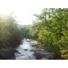
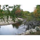
Warren: Baker River, Warren NH
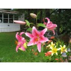
Warren: Beautiful flowers grown by Deb Ferland Warren Village Estates
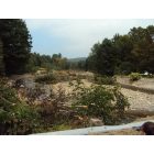
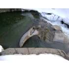
Warren: The devastation of Irene on Studio Rd of the Baker River
Warren: a "shout" out to Mount Moosilauke
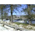
Warren: Scenic View Campground Lot 24 View
- add
your
Submit your own pictures of this town and show them to the world
- OSM Map
- General Map
- Google Map
- MSN Map
Population change since 2000: +3.6%
 |
| Males: 465 | |
| Females: 439 |
| Median resident age: | 45.2 years |
| New Hampshire median age: | 43.9 years |
Zip codes: 03279.
| Warren: | $67,322 |
| NH: | $89,992 |
Estimated per capita income in 2022: $37,416 (it was $16,454 in 2000)
Warren town income, earnings, and wages data
Estimated median house or condo value in 2022: $225,973 (it was $70,700 in 2000)
| Warren: | $225,973 |
| NH: | $384,700 |
Mean prices in 2022: all housing units: $486,096; detached houses: $533,852; townhouses or other attached units: $375,744; in 2-unit structures: $230,260; in 3-to-4-unit structures: $242,363; in 5-or-more-unit structures: $588,257; mobile homes: $127,035
Detailed information about poverty and poor residents in Warren, NH
Compare current foreclosures near Warren, NH:
| Photo | Address | Area | Beds / Baths | Price | Details |
|---|---|---|---|---|---|

|
#1
Nh Route 118
Warren, NH 03279
|
- sq. feet
|
- baths - beds |
show details | |

|
#2
Hallelujah Ave
Rumney, NH 03266
|
981 sq. feet
|
1 baths 1 beds |
show details | |

|
#3
Adams St
Haverhill, NH 03765
|
1,017 sq. feet
|
1 baths 2 beds |
show details | |

|
#4
Depot St
Haverhill, NH 03765
|
- sq. feet
|
- baths - beds |
show details | |

|
#5
Streeter Woods Rd
Rumney, NH 03266
|
- sq. feet
|
- baths - beds |
show details | |

|
#6
Beaver Path
Thornton, NH 03285
|
- sq. feet
|
- baths - beds |
show details | |

|
#7
New Hebron Rd
Plymouth, NH 03264
|
- sq. feet
|
- baths - beds |
show details | |

|
#8
Summit Dr
Campton, NH 03223
|
- sq. feet
|
- baths - beds |
show details | |

|
#9
Sugar Hill Rd
Franconia, NH 03580
|
- sq. feet
|
- baths - beds |
show details | |

|
#10
Eastside Rd
North Woodstock, NH 03262
|
- sq. feet
|
- baths - beds |
show details |
| Photo | Address | Area | Beds / Baths | Price | Details |
|---|---|---|---|---|---|

|
#11
Mountain Rd
Fairlee, VT 05045
|
- sq. feet
|
- baths - beds |
show details | |

|
#12
Adams Dr
Woodsville, NH 03785
|
- sq. feet
|
- baths - beds |
show details | |

|
#13
Mayhew Tpke
Plymouth, NH 03264
|
- sq. feet
|
- baths - beds |
show details | |

|
#14
Fairgrounds Rd
Plymouth, NH 03264
|
- sq. feet
|
- baths - beds |
show details | |

|
#15
Skyline Dr
Fairlee, VT 05045
|
- sq. feet
|
- baths - beds |
show details | |

|
#16
Wallace Hill Rd
Wells River, VT 05081
|
- sq. feet
|
- baths - beds |
show details | |

|
Check over 1 million property listings on Foreclosure.com!
|
browse all offers | |||

- 87196.3%White alone
- 222.4%Two or more races
- 50.6%Hispanic
- 30.3%American Indian alone
- 20.2%Black alone
- 10.1%Asian alone

Races in Warren detailed stats: ancestries, foreign born residents, place of birth
According to our research of New Hampshire and other state lists, there was 1 registered sex offender living in Warren, New Hampshire as of June 01, 2024.
The ratio of all residents to sex offenders in Warren is 904 to 1.
The ratio of registered sex offenders to all residents in this city is lower than the state average.
Full-time law enforcement employees in 2021, including police officers: 1 (1 officers - 1 male; 0 female).
| Officers per 1,000 residents here: | 1.05 |
| New Hampshire average: | 2.14 |
 Recent articles from our blog. Our writers, many of them Ph.D. graduates or candidates, create easy-to-read articles on a wide variety of topics.

 | where to buy a 500-gallon propane tank? (56 replies) |
| A sampling of squatters (Before Corona) (40 replies) |
| NH democrats try once again to enact back door income tax. (55 replies) |
| Recommendations affordable living Lebanon area (9 replies) |
| Live Free or Die? Why do so many candidates want to restrict freedom? (22 replies) |
| Moving too Milan or Berlin from Tennessee. (24 replies) |
Latest news from Warren, NH collected exclusively by city-data.com from local newspapers, TV, and radio stations
Ancestries: English (28.3%), French (19.5%), Irish (12.5%), United States (10.7%), Scottish (7.1%), German (6.4%).
Current Local Time: EST time zone
Incorporated in 1763
Elevation: 770 feet
Land area: 48.7 square miles.
Population density: 19 people per square mile (very low).

11 residents are foreign born
| This town: | 1.3% |
| New Hampshire: | 4.4% |
| Warren town: | 2.0% ($1,394) |
| New Hampshire: | 2.3% ($2,946) |
Nearest city with pop. 50,000+: Manchester, NH  (69.4 miles , pop. 107,006).
Nearest city with pop. 200,000+: Boston, MA (118.9 miles , pop. 589,141).
Nearest city with pop. 1,000,000+: Bronx, NY (236.6 miles , pop. 1,332,650).
Nearest cities:
), ), ), ), ), )Latitude: 43.94 N, Longitude: 71.89 W
Area code: 603


Single-family new house construction building permits:
- 2011: 2 buildings, average cost: $200,000
- 2010: 2 buildings, average cost: $200,000
- 2009: 2 buildings, average cost: $200,000
- 2008: 3 buildings, average cost: $200,000
- 2007: 4 buildings, average cost: $200,000
- 2006: 6 buildings, average cost: $93,300
- 2005: 8 buildings, average cost: $93,300
- 2004: 9 buildings, average cost: $93,300
- 2003: 6 buildings, average cost: $132,800
- 2002: 4 buildings, average cost: $94,300
- 2001: 6 buildings, average cost: $73,700
- 2000: 8 buildings, average cost: $118,000
- 1999: 5 buildings, average cost: $40,000
- 1998: 3 buildings, average cost: $30,000
- 1997: 3 buildings, average cost: $30,000


| Here: | 1.9% |
| New Hampshire: | 2.5% |


- Health care (13.8%)
- Educational services (9.5%)
- Wood products (8.6%)
- Construction (6.9%)
- Accommodation & food services (5.5%)
- Public administration (5.2%)
- Agriculture, forestry, fishing & hunting (3.8%)

- Construction (13.6%)
- Wood products (11.3%)
- Agriculture, forestry, fishing & hunting (7.5%)
- Truck transportation (5.2%)
- Public administration (4.7%)
- Lumber & other construction materials merchant wholesalers (4.7%)
- Accommodation & food services (4.7%)

- Health care (23.7%)
- Educational services (15.0%)
- Accommodation & food services (6.3%)
- Wood products (5.8%)
- Public administration (5.8%)
- Finance & insurance (5.3%)
- Food & beverage stores (3.9%)

- Building and grounds cleaning and maintenance occupations (6.4%)
- Information and record clerks, except customer service representatives (5.0%)
- Laborers and material movers, hand (4.3%)
- Other production occupations, including supervisors (4.0%)
- Other management occupations, except farmers and farm managers (4.0%)
- Material recording, scheduling, dispatching, and distributing workers (3.6%)
- Driver/sales workers and truck drivers (2.9%)

- Other management occupations, except farmers and farm managers (7.0%)
- Other production occupations, including supervisors (7.0%)
- Laborers and material movers, hand (6.6%)
- Fishing, hunting, and forestry occupations (5.2%)
- Driver/sales workers and truck drivers (5.2%)
- Carpenters (4.7%)
- Metal workers and plastic workers (3.8%)

- Building and grounds cleaning and maintenance occupations (10.1%)
- Information and record clerks, except customer service representatives (9.2%)
- Nursing, psychiatric, and home health aides (5.8%)
- Cashiers (5.3%)
- Secretaries and administrative assistants (4.3%)
- Registered nurses (4.3%)
- Material recording, scheduling, dispatching, and distributing workers (3.9%)
Average climate in Warren, New Hampshire
Based on data reported by over 4,000 weather stations


(lower is better)

Air Quality Index (AQI) level in 2021 was 39.8. This is significantly better than average.
| City: | 39.8 |
| U.S.: | 72.6 |

Ozone [ppb] level in 2021 was 25.7. This is better than average. Closest monitor was 9.3 miles away from the city center.
| City: | 25.7 |
| U.S.: | 33.3 |

Tornado activity:
Warren-area historical tornado activity is below New Hampshire state average. It is 75% smaller than the overall U.S. average.
On 8/11/1966, a category F2 (max. wind speeds 113-157 mph) tornado 9.3 miles away from the Warren town center caused between $50,000 and $500,000 in damages.
On 5/11/1973, a category F2 tornado 25.7 miles away from the town center .
Earthquake activity:
Warren-area historical earthquake activity is significantly above New Hampshire state average. It is 71% smaller than the overall U.S. average.On 4/20/2002 at 10:50:47, a magnitude 5.3 (5.3 ML, Depth: 3.0 mi, Class: Moderate, Intensity: VI - VII) earthquake occurred 98.1 miles away from the city center
On 4/20/2002 at 10:50:47, a magnitude 5.2 (5.2 MB, 4.2 MS, 5.2 MW, 5.0 MW) earthquake occurred 98.3 miles away from the city center
On 10/7/1983 at 10:18:46, a magnitude 5.3 (5.1 MB, 5.3 LG, 5.1 ML) earthquake occurred 122.2 miles away from Warren center
On 1/19/1982 at 00:14:42, a magnitude 4.7 (4.5 MB, 4.7 MD, 4.5 LG, Class: Light, Intensity: IV - V) earthquake occurred 33.6 miles away from the city center
On 10/16/2012 at 23:12:25, a magnitude 4.7 (4.7 ML, Depth: 10.0 mi) earthquake occurred 65.9 miles away from the city center
On 6/16/1995 at 12:13:11, a magnitude 3.8 (3.8 LG, Depth: 3.1 mi, Class: Light, Intensity: II - III) earthquake occurred 24.1 miles away from Warren center
Magnitude types: regional Lg-wave magnitude (LG), body-wave magnitude (MB), duration magnitude (MD), local magnitude (ML), surface-wave magnitude (MS), moment magnitude (MW)
Natural disasters:
The number of natural disasters in Grafton County (32) is a lot greater than the US average (15).Major Disasters (Presidential) Declared: 20
Emergencies Declared: 9
Causes of natural disasters: Floods: 16, Storms: 16, Hurricanes: 3, Snows: 3, Winter Storms: 3, Tropical Storms: 2, Blizzard: 1, Heavy Rain: 1, Ice Storm: 1, Landslide: 1, Snowfall: 1, Snowstorm: 1, Wind: 1, Other: 1 (Note: some incidents may be assigned to more than one category).

Hospitals and medical centers near Warren:
- GLENCLIFF HOME FOR THE ELDERLY (Nursing Home, about 4 miles away; GLENCLIFF, NH)
- GRAFTON COUNTY NURSING HOME (Nursing Home, about 13 miles away; NORTH HAVERHILL, NH)
- COTTAGE HOSPITAL Critical Access Hospitals (about 13 miles away; WOODSVILLE, NH)
- SPEARE MEMORIAL HOSPITAL Critical Access Hospitals (about 16 miles away; PLYMOUTH, NH)
Colleges/universities with over 2000 students nearest to Warren:
- Plymouth State University (about 16 miles; Plymouth, NH; Full-time enrollment: 4,838)
- Dartmouth College (about 26 miles; Hanover, NH; FT enrollment: 6,030)
- Norwich University (about 41 miles; Northfield, VT; FT enrollment: 4,221)
- NHTI-Concord's Community College (about 53 miles; Concord, NH; FT enrollment: 2,865)
- Middlebury College (about 65 miles; Middlebury, VT; FT enrollment: 3,077)
- Southern New Hampshire University (about 66 miles; Manchester, NH; FT enrollment: 16,552)
- Castleton State College (about 69 miles; Castleton, VT; FT enrollment: 2,079)
Public elementary/middle school in Warren:
- WARREN VILLAGE SCHOOL (Students: 76, Location: 11 SCHOOL ST., Grades: PK-7)
Points of interest:
Notable locations in Warren: Moosilauke Golf Club (A), New Hampshire State Fish Hatchery (B), Warren - Wentworth Ambulance Service (C), Warren Fire Department (D). Display/hide their locations on the map
Churches in Warren include: Saint Johns Chapel (A), Warren Methodist Church (B). Display/hide their locations on the map
Lakes and reservoirs: Wachipauka Pond (A), Three Ponds (B), Foxglove Pond (C), Baker Floodwater Reservoir Site (D). Display/hide their locations on the map
Streams, rivers, and creeks: Hurricane Brook (A), Merrill Brook (B), East Branch Baker River (C), Blodgett Brook (D), Black Brook (E), Big Brook (F), Berry Brook (G), Batchelder Brook (H), Little Brook (I). Display/hide their locations on the map
Hotel: Warren Village Inn LLC (254 Nh Route 25) (1). Display/hide its approximate location on the map
Birthplace of: Norris Cotton - Politician.
Drinking water stations with addresses in Warren and their reported violations in the past:
SCENIC VIEW CAMPGROUND (Population served: 248, Groundwater):Past health violations:
- MCL, Monthly (TCR) - Between JUL-2012 and SEP-2012, Contaminant: Coliform. Follow-up actions: St Public Notif requested (AUG-29-2012), St Violation/Reminder Notice (AUG-29-2012), St Public Notif received (SEP-05-2012), St Compliance achieved (FEB-13-2013)
| This town: | 2.4 people |
| New Hampshire: | 2.5 people |
| This town: | 62.5% |
| Whole state: | 66.3% |
| This town: | 9.7% |
| Whole state: | 8.3% |
Likely homosexual households (counted as self-reported same-sex unmarried-partner households)
- Lesbian couples: 0.0% of all households
- Gay men: 0.3% of all households
| This town: | 10.7% |
| Whole state: | 6.5% |
| This town: | 2.2% |
| Whole state: | 2.8% |
For population 15 years and over in Warren:

- Never married: 24.5%
- Now married: 56.5%
- Separated: 0.9%
- Widowed: 6.7%
- Divorced: 11.5%
For population 25 years and over in Warren:
- High school or higher: 78.0%
- Bachelor's degree or higher: 14.4%
- Graduate or professional degree: 5.4%
- Unemployed: 7.7%
- Mean travel time to work (commute): 30.9 minutes


| Here: | 11.2 |
| New Hampshire average: | 10.9 |


Graphs represent county-level data. Detailed 2008 Election Results
Religion statistics for Warren, NH (based on Grafton County data)


| Religion | Adherents | Congregations |
|---|---|---|
| Catholic | 9,503 | 12 |
| Mainline Protestant | 7,832 | 57 |
| Evangelical Protestant | 1,494 | 29 |
| Other | 1,320 | 11 |
| None | 68,969 | - |
Food Environment Statistics:
| Here: | 3.87 / 10,000 pop. |
| State: | 2.14 / 10,000 pop. |
| Here: | 0.23 / 10,000 pop. |
| New Hampshire: | 0.15 / 10,000 pop. |
| Grafton County: | 1.29 / 10,000 pop. |
| State: | 1.78 / 10,000 pop. |
| Here: | 6.45 / 10,000 pop. |
| State: | 4.02 / 10,000 pop. |
| Grafton County: | 14.41 / 10,000 pop. |
| New Hampshire: | 9.70 / 10,000 pop. |
| This county: | 7.2% |
| New Hampshire: | 7.6% |
| Grafton County: | 22.9% |
| New Hampshire: | 24.4% |
| Here: | 15.9% |
| State: | 15.9% |
Strongest AM radio stations in Warren:
- WPNH (1300 AM; 5 kW; PLYMOUTH, NH; Owner: NORTHEAST COMMUNICATIONS CORPORATION)
- WTWN (1100 AM; daytime; 5 kW; WELLS RIVER, VT; Owner: PUFFER BROADCASTING, INC.)
- WRKO (680 AM; 50 kW; BOSTON, MA; Owner: ENTERCOM BOSTON LICENSE, LLC)
- WNTK (1020 AM; 10 kW; NEWPORT, NH; Owner: KOOR COMMUNICATIONS, INC.)
- WNNZ (640 AM; 50 kW; WESTFIELD, MA; Owner: CLEAR CHANNEL BROADCASTING LICENSES, INC.)
- WCRN (830 AM; 50 kW; WORCESTER, MA; Owner: CARTER BROADCASTING CORPORATION)
- WCHP (760 AM; 35 kW; CHAMPLAIN, NY; Owner: CHAMPLAIN RADIO, INC.)
- WEEI (850 AM; 50 kW; BOSTON, MA; Owner: ENTERCOM BOSTON LICENSE, LLC)
- WGY (810 AM; 50 kW; SCHENECTADY, NY; Owner: CLEAR CHANNEL BROADCASTING LICENSES, INC.)
- WDEV (550 AM; 5 kW; WATERBURY, VT; Owner: RADIO VERMONT, INC.)
- WKOX (1200 AM; 50 kW; FRAMINGHAM, MA; Owner: CAPSTAR TX LIMITED PARTNERSHIP)
- WBZ (1030 AM; 50 kW; BOSTON, MA; Owner: INFINITY BROADCASTING OPERATIONS, INC.)
- WEZS (1350 AM; 5 kW; LACONIA, NH; Owner: GARY W. HAMMOND)
Strongest FM radio stations in Warren:
- WVFM (105.7 FM; CAMPTON, NH; Owner: DEVON BROADCASTING COMPANY, INC.)
- WPNH-FM (100.1 FM; PLYMOUTH, NH; Owner: NORTHEAST COMMUNICATIONS CORPORATION)
- WPKQ (103.7 FM; NORTH CONWAY, NH; Owner: CITADEL BROADCASTING COMPANY)
- WHOM (94.9 FM; MT. WASHINGTON, NH; Owner: CITADEL BROADCASTING COMPANY)
- WEVH (91.3 FM; HANOVER, NH; Owner: NEW HAMPSHIRE PUBLIC RADIO INC)
- WSCY (106.9 FM; MOULTONBOROUGH, NH; Owner: NORTHEAST COMMUNICATIONS CORPORATION)
- WHDQ (106.1 FM; CLAREMONT, NH; Owner: GREAT NORTHERN RADIO, L.L.C.)
- WGMT (97.7 FM; LYNDON, VT; Owner: VERMONT BROADCAST ASSOCIATES, INC.)
- WMTK (106.3 FM; LITTLETON, NH; Owner: VERMONT BROADCAST ASSOCIATES, INC.)
- WVPR (89.5 FM; WINDSOR, VT; Owner: VERMONT PUBLIC RADIO)
- WEBK (105.3 FM; KILLINGTON, VT; Owner: 6 JOHNSON ROAD LICENSES, INC.)
- WJJR (98.1 FM; RUTLAND, VT; Owner: 6 JOHNSON ROAD LICENSES, INC.)
- WZRT (97.1 FM; RUTLAND, VT; Owner: CAPSTAR TX LIMITED PARTNERSHIP)
- WCVT (101.7 FM; STOWE, VT; Owner: RADIO VERMONT CLASSICS, L.L.C.)
- WLTN-FM (96.7 FM; LISBON, NH; Owner: PROFILE BROADCASTING CO., INC.)
- WGLV (91.7 FM; WOODSTOCK, VT; Owner: CHRISTIAN MINISTRIES INC)
- WHDQ-FM1 (106.1 FM; RUTLAND, VT; Owner: GREAT NORTHERN RADIO, L.L.C.)
- WDEV-FM (96.1 FM; WARREN, VT; Owner: RADIO VERMONT, INC.)
- WVPS (107.9 FM; BURLINGTON, VT; Owner: VERMONT PUBLIC RADIO)
- WLKC (103.3 FM; WATERBURY, VT; Owner: RADIO BROADCASTING SERVICES, INC.)
TV broadcast stations around Warren:
- WMTW-TV (Channel 8; POLAND SPRING, ME; Owner: WMTW BROADCAST GROUP, LLC)
- W15BK (Channel 15; HANOVER, NH; Owner: UNIVERSITY OF NEW HAMPSHIRE)
Warren fatal accident list:
Jan 10, 2000 08:48 PM, Sr-25, Vehicles: 1, Persons: 1, Fatalities: 1, Drunk persons involved: 1
Jul 2, 1989 05:40 PM, 23542, Vehicles: 1, Persons: 3, Fatalities: 1, Drunk persons involved: 1
Nov 29, 1989 11:40 PM, 23235, Vehicles: 2, Persons: 4, Fatalities: 3
- National Bridge Inventory (NBI) Statistics
- 14Number of bridges
- 85ft / 26.4mTotal length
- $43,988,000Total costs
- 13,142Total average daily traffic
- 493Total average daily truck traffic
- 19,441Total future (year 2042) average daily traffic

- New bridges - historical statistics
- 21930-1939
- 11940-1949
- 21950-1959
- 41960-1969
- 21970-1979
- 11980-1989
- 22000-2009
FCC Registered Antenna Towers:
8 (See the full list of FCC Registered Antenna Towers in Warren)FCC Registered Broadcast Land Mobile Towers:
1- Warren Fire Dept, 12 Water Street (Lat: 43.925667 Lon: -71.891417), Type: Ltower, Structure height: 13.7 m, Call Sign: WPZW929,
Assigned Frequencies: 159.900 MHz, 154.280 MHz, 159.900 MHz, 160.110 MHz, 160.155 MHz, Grant Date: 03/26/2014, Expiration Date: 03/31/2024, Certifier: Douglas M Aiken, Registrant: Lakes Region Mutual Fire Aid Association, 62 Communications Drive, Laconia, NH 03246, Phone: (603) 528-9111, Fax: (603) 528-5989, Email:
FCC Registered Amateur Radio Licenses:
10 (See the full list of FCC Registered Amateur Radio Licenses in Warren)FAA Registered Aircraft:
3- Aircraft: CESSNA R182 (Category: Land, Seats: 4, Weight: Up to 12,499 Pounds, Speed: 111 mph), Engine: LYCOMING 0-540 SERIES (250 HP) (Reciprocating)
N-Number: 3621C, N3621C, N-3621C, Serial Number: R18200280, Year manufactured: 1978, Airworthiness Date: 04/12/1978, Certificate Issue Date: 12/04/2019
Registrant (LLC): Airplane 1 LLC, 660 Beech Hill Rd, Warren, NH 03279 - Aircraft: ROBINSON HELICOPTER R44 (Category: Land, Seats: 4, Weight: Up to 12,499 Pounds), Engine: LYCOMING O-540-F1B5 (260 HP) (Reciprocating)
N-Number: 562T, N562T, N-562T, Serial Number: 2121, Year manufactured: 2011, Airworthiness Date: 04/19/2011, Certificate Issue Date: 03/22/2016
Registrant (LLC): Vcs Acquisition LLC, 220 Swain Hill Rd, Warren, NH 03279 - Aircraft: MAULE M-7-260C (Category: Land, Seats: 5, Weight: Up to 12,499 Pounds), Engine: LYCOMING IO-540-V4A5D (260 HP) (Reciprocating)
N-Number: 753DW, N753DW, N-753DW, Serial Number: 30043C, Year manufactured: 2008, Airworthiness Date: 07/08/2008, Certificate Issue Date: 06/01/2016
Registrant (LLC): Vcs Acquisition LLC, 220 Swain Hill Rd, Warren, NH 03279

- 65.4%Fuel oil, kerosene, etc.
- 18.5%Wood
- 14.7%Bottled, tank, or LP gas
- 0.7%Electricity
- 0.7%Coal or coke

- 61.7%Fuel oil, kerosene, etc.
- 21.7%Bottled, tank, or LP gas
- 16.7%Wood
Warren compared to New Hampshire state average:
- Median house value below state average.
- Black race population percentage significantly below state average.
- Hispanic race population percentage significantly below state average.
- Foreign-born population percentage significantly below state average.
- Renting percentage below state average.
- Length of stay since moving in significantly above state average.
- Number of rooms per house significantly below state average.
- House age significantly below state average.
- Percentage of population with a bachelor's degree or higher below state average.