Wheatland, New York
Submit your own pictures of this town and show them to the world
- OSM Map
- Google Map
- MSN Map
Population change since 2000: -7.3%
 |
| Males: 2,392 | |
| Females: 2,383 |
| Median resident age: | 42.6 years |
| New York median age: | 40.7 years |
Zip codes: 14546.
| Wheatland: | $83,580 |
| NY: | $79,557 |
Estimated per capita income in 2022: $42,598 (it was $24,024 in 2000)
Wheatland town income, earnings, and wages data
Estimated median house or condo value in 2022: $198,470 (it was $97,400 in 2000)
| Wheatland: | $198,470 |
| NY: | $400,400 |
Mean prices in 2022: all housing units: $223,138; detached houses: $228,957; townhouses or other attached units: $212,541; in 2-unit structures: $243,541; in 3-to-4-unit structures: $249,438; in 5-or-more-unit structures: $387,764; mobile homes: $74,393; occupied boats, rvs, vans, etc.: $198,823
Detailed information about poverty and poor residents in Wheatland, NY


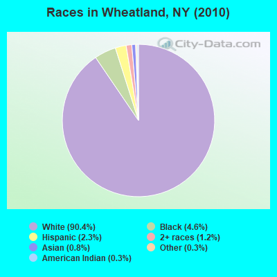
- 4,31690.4%White alone
- 2204.6%Black alone
- 1102.3%Hispanic
- 581.2%Two or more races
- 390.8%Asian alone
- 140.3%American Indian alone
- 150.3%Other race alone
- 30.06%Native Hawaiian and Other
Pacific Islander alone
Races in Wheatland detailed stats: ancestries, foreign born residents, place of birth
According to our research of New York and other state lists, there was 1 registered sex offender living in Wheatland, New York as of May 21, 2024.
The ratio of all residents to sex offenders in Wheatland is 4,775 to 1.
The ratio of registered sex offenders to all residents in this city is much lower than the state average.
 Recent articles from our blog. Our writers, many of them Ph.D. graduates or candidates, create easy-to-read articles on a wide variety of topics.

Ancestries: German (26.2%), Irish (21.7%), English (19.4%), Italian (13.2%), United States (9.8%), Polish (6.4%).
Current Local Time: EST time zone
Land area: 30.6 square miles.
Population density: 156 people per square mile (very low).
83 residents are foreign born
| This town: | 1.6% |
| New York: | 20.4% |
| Wheatland town: | 2.7% ($2,673) |
| New York: | 1.9% ($2,847) |
Nearest city with pop. 50,000+: Rochester, NY  (14.9 miles , pop. 219,773).
Nearest city with pop. 1,000,000+: Philadelphia, PA (250.0 miles , pop. 1,517,550).
Nearest cities:
), ), ), ), ), Latitude: 43.01 N, Longitude: 77.82 W
Area code commonly used in this area: 585
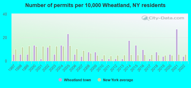
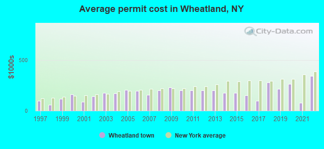
Single-family new house construction building permits:
- 2022: 2 buildings, average cost: $342,500
- 2021: 14 buildings, average cost: $80,000
- 2020: 3 buildings, average cost: $261,700
- 2019: 2 buildings, average cost: $213,500
- 2018: 4 buildings, average cost: $279,300
- 2017: 1 building, cost: $100,000
- 2016: 5 buildings, average cost: $150,000
- 2015: 7 buildings, average cost: $175,000
- 2014: 9 buildings, average cost: $175,000
- 2013: 1 building, cost: $200,000
- 2012: 1 building, cost: $200,000
- 2011: 1 building, cost: $200,000
- 2010: 1 building, cost: $200,000
- 2009: 4 buildings, average cost: $230,000
- 2008: 4 buildings, average cost: $201,800
- 2007: 2 buildings, average cost: $155,000
- 2006: 3 buildings, average cost: $196,700
- 2005: 12 buildings, average cost: $206,200
- 2004: 7 buildings, average cost: $169,700
- 2003: 3 buildings, average cost: $176,700
- 2002: 6 buildings, average cost: $144,000
- 2001: 1 building, cost: $90,000
- 2000: 7 buildings, average cost: $163,100
- 1999: 3 buildings, average cost: $115,000
- 1998: 3 buildings, average cost: $60,000
- 1997: 3 buildings, average cost: $98,000
| Here: | 4.1% |
| New York: | 4.4% |
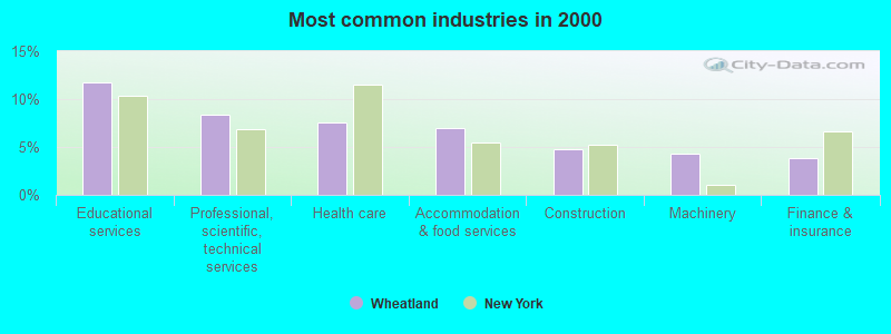
- Educational services (11.8%)
- Professional, scientific, technical services (8.4%)
- Health care (7.6%)
- Accommodation & food services (6.9%)
- Construction (4.8%)
- Machinery (4.3%)
- Finance & insurance (3.8%)
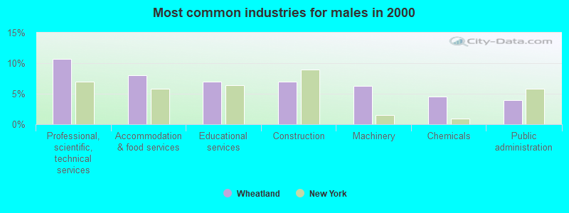
- Professional, scientific, technical services (10.7%)
- Accommodation & food services (8.0%)
- Educational services (7.0%)
- Construction (6.9%)
- Machinery (6.3%)
- Chemicals (4.5%)
- Public administration (3.9%)
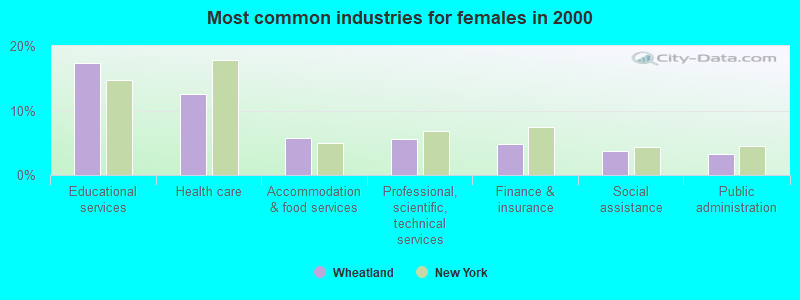
- Educational services (17.3%)
- Health care (12.6%)
- Accommodation & food services (5.7%)
- Professional, scientific, technical services (5.6%)
- Finance & insurance (4.8%)
- Social assistance (3.7%)
- Public administration (3.3%)
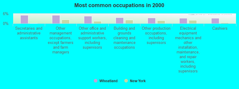
- Secretaries and administrative assistants (5.1%)
- Other management occupations, except farmers and farm managers (5.0%)
- Other office and administrative support workers, including supervisors (4.6%)
- Building and grounds cleaning and maintenance occupations (3.6%)
- Other production occupations, including supervisors (3.4%)
- Electrical equipment mechanics and other installation, maintenance, and repair workers, including supervisors (3.2%)
- Cashiers (3.2%)
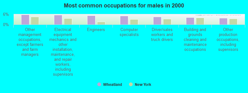
- Other management occupations, except farmers and farm managers (5.7%)
- Electrical equipment mechanics and other installation, maintenance, and repair workers, including supervisors (5.5%)
- Engineers (5.3%)
- Computer specialists (5.1%)
- Driver/sales workers and truck drivers (4.6%)
- Building and grounds cleaning and maintenance occupations (4.1%)
- Other production occupations, including supervisors (3.8%)
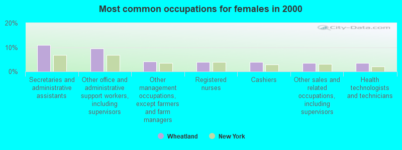
- Secretaries and administrative assistants (11.0%)
- Other office and administrative support workers, including supervisors (9.6%)
- Other management occupations, except farmers and farm managers (4.2%)
- Registered nurses (4.0%)
- Cashiers (3.9%)
- Other sales and related occupations, including supervisors (3.5%)
- Health technologists and technicians (3.5%)
Average climate in Wheatland, New York
Based on data reported by over 4,000 weather stations


(lower is better)
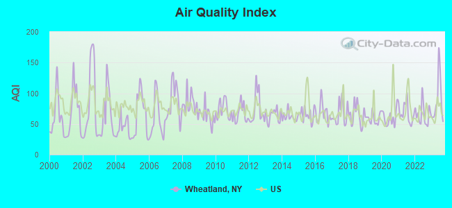
Air Quality Index (AQI) level in 2023 was 88.5. This is worse than average.
| City: | 88.5 |
| U.S.: | 72.6 |
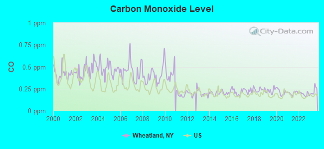
Carbon Monoxide (CO) [ppm] level in 2023 was 0.225. This is about average. Closest monitor was 12.4 miles away from the city center.
| City: | 0.225 |
| U.S.: | 0.251 |
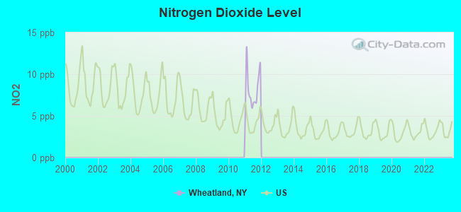
Nitrogen Dioxide (NO2) [ppb] level in 2011 was 8.11. This is significantly worse than average. Closest monitor was 15.0 miles away from the city center.
| City: | 8.11 |
| U.S.: | 5.11 |

Sulfur Dioxide (SO2) [ppb] level in 2023 was 0.128. This is significantly better than average. Closest monitor was 7.6 miles away from the city center.
| City: | 0.128 |
| U.S.: | 1.515 |
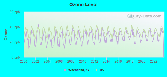
Ozone [ppb] level in 2023 was 31.3. This is about average. Closest monitor was 6.9 miles away from the city center.
| City: | 31.3 |
| U.S.: | 33.3 |
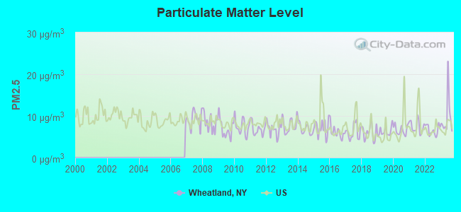
Particulate Matter (PM2.5) [µg/m3] level in 2023 was 9.83. This is worse than average. Closest monitor was 15.0 miles away from the city center.
| City: | 9.83 |
| U.S.: | 8.11 |
Tornado activity:
Wheatland-area historical tornado activity is below New York state average. It is 79% smaller than the overall U.S. average.
On 6/20/1969, a category F3 (max. wind speeds 158-206 mph) tornado 49.1 miles away from the Wheatland town center caused between $500,000 and $5,000,000 in damages.
On 5/2/1972, a category F2 (max. wind speeds 113-157 mph) tornado 28.4 miles away from the town center caused between $50,000 and $500,000 in damages.
Earthquake activity:
Wheatland-area historical earthquake activity is significantly above New York state average. It is 68% smaller than the overall U.S. average.On 10/7/1983 at 10:18:46, a magnitude 5.3 (5.1 MB, 5.3 LG, 5.1 ML, Class: Moderate, Intensity: VI - VII) earthquake occurred 186.1 miles away from Wheatland center
On 9/25/1998 at 19:52:52, a magnitude 5.2 (4.8 MB, 4.3 MS, 5.2 LG, 4.5 MW, Depth: 3.1 mi) earthquake occurred 168.7 miles away from Wheatland center
On 4/20/2002 at 10:50:47, a magnitude 5.3 (5.3 ML, Depth: 3.0 mi) earthquake occurred 230.5 miles away from Wheatland center
On 4/20/2002 at 10:50:47, a magnitude 5.2 (5.2 MB, 4.2 MS, 5.2 MW, 5.0 MW) earthquake occurred 228.8 miles away from Wheatland center
On 1/31/1986 at 16:46:43, a magnitude 5.0 (5.0 MB) earthquake occurred 196.8 miles away from Wheatland center
On 8/23/2011 at 17:51:04, a magnitude 5.8 (5.8 MW, Depth: 3.7 mi) earthquake occurred 352.8 miles away from the city center
Magnitude types: regional Lg-wave magnitude (LG), body-wave magnitude (MB), local magnitude (ML), surface-wave magnitude (MS), moment magnitude (MW)
Natural disasters:
The number of natural disasters in Monroe County (17) is near the US average (15).Major Disasters (Presidential) Declared: 10
Emergencies Declared: 6
Causes of natural disasters: Floods: 5, Storms: 5, Winter Storms: 3, Hurricanes: 2, Ice Storms: 2, Blizzard: 1, Power Outage: 1, Tropical Storm: 1, Wind: 1, Other: 2 (Note: some incidents may be assigned to more than one category).
Hospitals and medical centers near Wheatland:
- MARY CARIOLA CHILDREN'S CENTER, INC (Hospital, about 6 miles away; RUSH, NY)
- LIFETIME ASSISTANCE, INC (Hospital, about 8 miles away; ROCHESTER, NY)
- LIFETIME ASSISTANCE, INC (Hospital, about 8 miles away; CHURCHVILLE, NY)
- AVON NURSING HOME (Nursing Home, about 9 miles away; AVON, NY)
- LIFETIME ASSISTANCE, INC (Hospital, about 9 miles away; ROCHESTER, NY)
- LEROY VILLAGE GREEN R H C F INC (Nursing Home, about 10 miles away; LEROY, NY)
- WESTGATE NURSING HOME (Nursing Home, about 11 miles away; ROCHESTER, NY)
Operable nuclear power plant near Wheatland:
- 15 miles: R.E. Ginna in Rochester, NY.
Colleges/universities with over 2000 students nearest to Wheatland:
- Rochester Institute of Technology (about 10 miles; Rochester, NY; Full-time enrollment: 14,177)
- Monroe Community College (about 13 miles; Rochester, NY; FT enrollment: 14,295)
- University of Rochester (about 13 miles; Rochester, NY; FT enrollment: 10,201)
- SUNY College at Geneseo (about 15 miles; Geneseo, NY; FT enrollment: 5,520)
- SUNY College at Brockport (about 16 miles; Brockport, NY; FT enrollment: 7,398)
- Genesee Community College (about 17 miles; Batavia, NY; FT enrollment: 4,290)
- Nazareth College (about 17 miles; Rochester, NY; FT enrollment: 2,632)
Points of interest:
Notable locations in Wheatland: Scottsville Sewage Plant (A), Wheatland Senior Center (B), Scottsville Free Library (C), Town of Wheatland Courthouse (D), Scottsville Town and Village Office Building (E), Scottsville Volunteer Fire Department (F), Mumford Fire Department (G). Display/hide their locations on the map
Churches in Wheatland include: Saint Patrick's Roman Catholic Church (A), Second Baptist Church (B), Mumford United Presbyterian Church (C), First Baptist Church (D). Display/hide their locations on the map
Cemeteries: Quaker Cemetery (1), Holy Angels Cemetery (2), Cox Cemetery (3), Warren Cemetery (4), Garbutt Cemetery (5), Mumford Rural Cemetery (6), Oatka Cemetery (7). Display/hide their locations on the map
Lake: Blue Pond (A). Display/hide its location on the map
Creek: Oatka Creek (A). Display/hide its location on the map
Park in Wheatland: Oatka Creek Park (1). Display/hide its location on the map
| This town: | 2.4 people |
| New York: | 2.6 people |
| This town: | 65.2% |
| Whole state: | 63.5% |
| This town: | 8.0% |
| Whole state: | 6.8% |
Likely homosexual households (counted as self-reported same-sex unmarried-partner households)
- Lesbian couples: 0.2% of all households
- Gay men: 0.6% of all households
| This town: | 3.5% |
| Whole state: | 14.6% |
| This town: | 2.1% |
| Whole state: | 7.4% |
12 people in homes for the mentally retarded in 2000
7 people in homes or halfway houses for drug/alcohol abuse in 2000
For population 15 years and over in Wheatland:
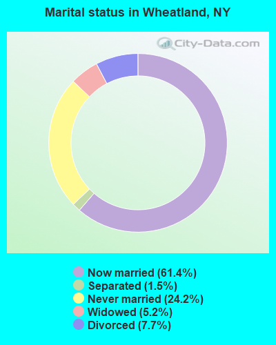
- Never married: 24.2%
- Now married: 61.4%
- Separated: 1.5%
- Widowed: 5.2%
- Divorced: 7.7%
For population 25 years and over in Wheatland:
- High school or higher: 91.1%
- Bachelor's degree or higher: 32.8%
- Graduate or professional degree: 12.7%
- Unemployed: 4.9%
- Mean travel time to work (commute): 23.5 minutes
| Here: | 10.2 |
| New York average: | 14.2 |
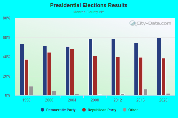
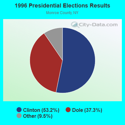
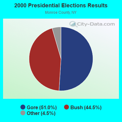
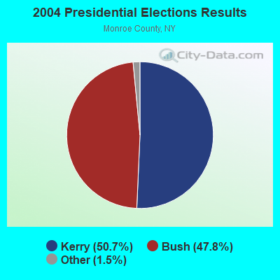
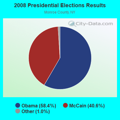
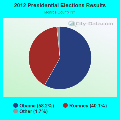
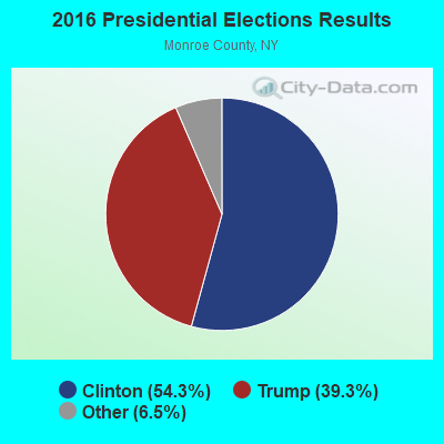
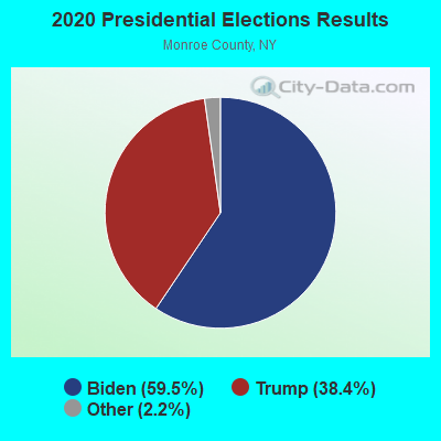
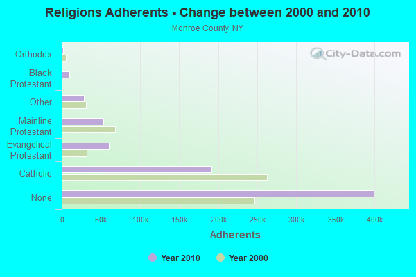
Graphs represent county-level data. Detailed 2008 Election Results
Religion statistics for Wheatland, NY (based on Monroe County data)
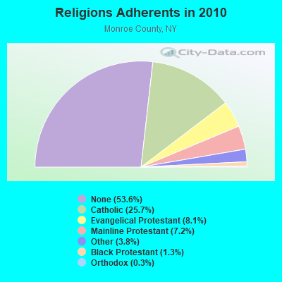
| Religion | Adherents | Congregations |
|---|---|---|
| Catholic | 191,112 | 65 |
| Evangelical Protestant | 60,385 | 240 |
| Mainline Protestant | 53,463 | 151 |
| Other | 28,550 | 74 |
| Black Protestant | 9,459 | 30 |
| Orthodox | 2,038 | 11 |
| None | 399,337 | - |
Food Environment Statistics:
| Monroe County: | 2.39 / 10,000 pop. |
| New York: | 4.13 / 10,000 pop. |
| This county: | 0.10 / 10,000 pop. |
| State: | 0.06 / 10,000 pop. |
| Monroe County: | 0.96 / 10,000 pop. |
| New York: | 0.92 / 10,000 pop. |
| This county: | 2.32 / 10,000 pop. |
| New York: | 1.68 / 10,000 pop. |
| Monroe County: | 7.54 / 10,000 pop. |
| New York: | 8.82 / 10,000 pop. |
| This county: | 7.9% |
| New York: | 8.2% |
| Monroe County: | 26.4% |
| New York: | 23.8% |
| This county: | 13.4% |
| State: | 15.6% |
3.45% of this county's 2021 resident taxpayers lived in other counties in 2020 ($64,907 average adjusted gross income)
| Here: | 3.45% |
| New York average: | 5.29% |
0.01% of residents moved from foreign countries ($70 average AGI)
Monroe County: 0.01% New York average: 0.01%
Top counties from which taxpayers relocated into this county between 2020 and 2021:
| from Ontario County, NY | |
| from Wayne County, NY | |
| from Erie County, NY |
4.11% of this county's 2020 resident taxpayers moved to other counties in 2021 ($66,936 average adjusted gross income)
| Here: | 4.11% |
| New York average: | 6.93% |
0.01% of residents moved to foreign countries ($84 average AGI)
Monroe County: 0.01% New York average: 0.02%
Top counties to which taxpayers relocated from this county between 2020 and 2021:
| to Ontario County, NY | |
| to Wayne County, NY | |
| to Livingston County, NY |
Strongest AM radio stations in Wheatland:
- WHAM (1180 AM; 50 kW; ROCHESTER, NY; Owner: CITICASTERS LICENSES, L.P.)
- WHTK (1280 AM; 5 kW; ROCHESTER, NY)
- WLGZ (990 AM; 5 kW; ROCHESTER, NY; Owner: KIMTRON, INC.)
- WXXI (1370 AM; 5 kW; ROCHESTER, NY; Owner: WXXI PUBLIC BROADCASTING COUNCIL)
- WHIC (1460 AM; 5 kW; ROCHESTER, NY; Owner: HOLY FAMILY COMMUNICATIONS)
- WYSL (1040 AM; 2 kW; AVON, NY; Owner: RADIO LIVINGSTON, LTD)
- WWKB (1520 AM; 50 kW; BUFFALO, NY; Owner: ENTERCOM BUFFALO LICENSE, LLC)
- WROC (950 AM; 1 kW; ROCHESTER, NY)
- WCJW (1140 AM; daytime; 2 kW; WARSAW, NY; Owner: LLOYD LANE, INCORPORATED)
- WTOR (770 AM; daytime; 9 kW; YOUNGSTOWN, NY; Owner: BIRACH BROADCASTING CORPORATION)
- WASB (1590 AM; 1 kW; BROCKPORT, NY; Owner: DAVID L. WOLFE)
- WGR (550 AM; 5 kW; BUFFALO, NY; Owner: ENTERCOM BUFFALO LICENSE, LLC)
- WACK (1420 AM; 5 kW; NEWARK, NY; Owner: PEMBROOK PINES, INC.)
Strongest FM radio stations in Wheatland:
- WRMM-FM (101.3 FM; ROCHESTER, NY; Owner: INFINITY RADIO OPERATIONS INC.)
- WBZA (98.9 FM; ROCHESTER, NY; Owner: ENTERCOM ROCHESTER LICENSE, LLC.)
- WDKX (103.9 FM; ROCHESTER, NY; Owner: MONROE COUNTY BROADCASTING CO., LTD.)
- WMJQ (105.5 FM; BROCKPORT, NY; Owner: CANANDAIGUA BROADCASTING, INC.)
- WDCZ-FM (102.7 FM; WEBSTER, NY; Owner: KIMTRON, INC.)
- WCIY (88.9 FM; CANANDAIGUA, NY; Owner: FAMILY LIFE MINISTRIES, INC.)
- WCMF-FM (96.5 FM; ROCHESTER, NY; Owner: INFINITY RADIO OPERATIONS INC.)
- WFXF (107.3 FM; SOUTH BRISTOL TOWNSH, NY; Owner: CITICASTERS LICENSES, L.P.)
- WNVE (95.1 FM; HONEOYE FALLS, NY; Owner: CITICASTERS LICENSES, L.P.)
- WXXI-FM (91.5 FM; ROCHESTER, NY; Owner: WXXI PUBLIC BROADCASTING COUNCIL)
- W238AB (95.5 FM; ROCHESTER, NY; Owner: CITICASTERS LICENSES, L.P.)
- WZNE (94.1 FM; BRIGHTON, NY; Owner: INFINITY RADIO OPERATIONS INC.)
- WPXY-FM (97.9 FM; ROCHESTER, NY; Owner: INFINITY RADIO OPERATIONS INC.)
- WISY (102.3 FM; CANANDAIGUA, NY; Owner: CITICASTERS LICENSES, L.P.)
- WRUR-FM (88.5 FM; ROCHESTER, NY; Owner: UNIVERSITY OF ROCHESTER B/CAST CORP.)
- WZXV (99.7 FM; PALMYRA, NY; Owner: CALVARY CHAPEL OF FINGER LAKES, INC.)
- WVOR-FM (100.5 FM; ROCHESTER, NY; Owner: CITICASTERS LICENSES, L.P.)
- WBEE-FM (92.5 FM; ROCHESTER, NY; Owner: ENTERCOM ROCHESTER LICENSE, LLC.)
- WKGS (106.7 FM; IRONDEQUOIT, NY; Owner: CITICASTERS LICENSES, L.P.)
- WCOU (88.3 FM; WARSAW, NY; Owner: FAMILY LIFE MINISTRIES, INC.)
TV broadcast stations around Wheatland:
- WPXJ-TV (Channel 51; BATAVIA, NY; Owner: PAXSON BUFFALO LICENSE, INC.)
- WBXO-LP (Channel 15; ROCHESTER, NY; Owner: METRO TV, INC.)
- WUHF (Channel 31; ROCHESTER, NY; Owner: WUHF LICENSEE, LLC)
- WOKR (Channel 13; ROCHESTER, NY; Owner: CENTRAL NY NEWS, INC.)
- WNYO-TV (Channel 49; BUFFALO, NY; Owner: NEW YORK TELEVISION, INC.)
- WGRZ-TV (Channel 2; BUFFALO, NY; Owner: MULTIMEDIA ENTERTAINMENT, INC.)
- WBGT-LP (Channel 40; ROCHESTER, NY; Owner: WBGT, LLC)
- WHEC-TV (Channel 10; ROCHESTER, NY; Owner: WHEC-TV, LLC)
- W42CO (Channel 42; ROCHESTER, NY; Owner: TRI-STATE CHRISTIAN TV, INC.)
- WROC-TV (Channel 8; ROCHESTER, NY; Owner: NEXSTAR BROADCASTING OF ROCHESTER, LLC)
- WXXI-TV (Channel 21; ROCHESTER, NY; Owner: WXXI PUBLIC BROADCASTING COUNCIL)
- W26BZ (Channel 26; VICTOR, NY; Owner: WBGT, LLC)
- WAWW-LP (Channel 38; ROCHESTER, NY; Owner: VENTURE TECHNOLOGIES GROUP, LLC)
- WROH-LP (Channel 47; ROCHESTER, NY; Owner: TIGER EYE BROADCASTING CORPORATION)
- National Bridge Inventory (NBI) Statistics
- 21Number of bridges
- 220ft / 67.0mTotal length
- $35,301,000Total costs
- 121,096Total average daily traffic
- 16,122Total average daily truck traffic
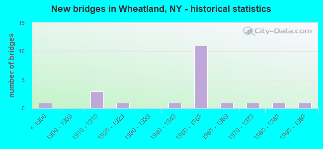
- New bridges - historical statistics
- 1Before 1900
- 31910-1919
- 11920-1929
- 11940-1949
- 111950-1959
- 11960-1969
- 11970-1979
- 11980-1989
- 11990-1999
FCC Registered Microwave Towers:
2- Lat: 43.042833 Lon: -77.773889, Overall height: 6.1 m, Call Sign: WPJF692,
Assigned Frequencies: 956.256 MHz, 956.256 MHz, Grant Date: 05/24/2001, Expiration Date: 07/09/2011, Cancellation Date: 09/10/2011, Registrant: Itron, Inc., 2111 N. Molter Rd., Liberty Lake, WA 99019, Phone: (509) 891-3636, Fax: (509) 891-3727, Email:
- MONROE, Lat: 43.032500 Lon: -77.667500, Call Sign: WPVZ478,
Assigned Frequencies: 956.406 MHz, Grant Date: 07/01/2022, Expiration Date: 09/19/2032, Certifier: Donald H Regoord, Registrant: Utilities Technology Council, 2550 South Clark St., Suite 960, Arlington, VA 22202, Phone: (202) 833-6818, Email:
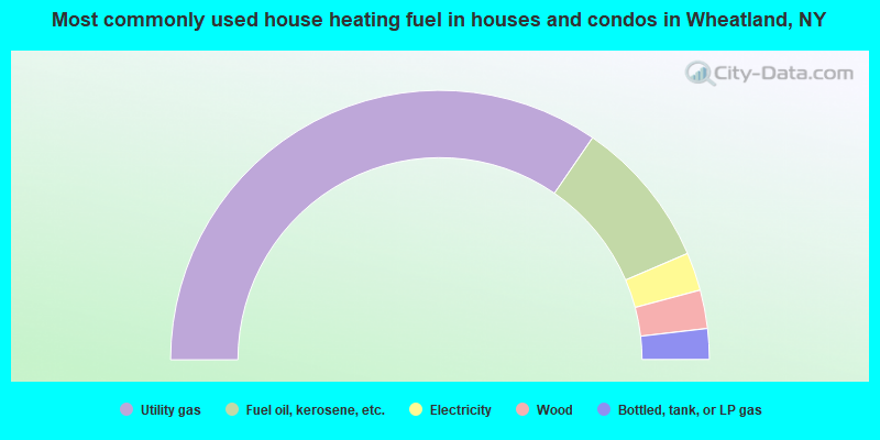
- 69.2%Utility gas
- 17.9%Fuel oil, kerosene, etc.
- 4.6%Electricity
- 4.6%Wood
- 3.7%Bottled, tank, or LP gas
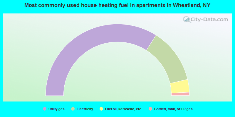
- 68.0%Utility gas
- 24.7%Electricity
- 5.8%Fuel oil, kerosene, etc.
- 1.5%Bottled, tank, or LP gas
Wheatland compared to New York state average:
- Median house value below state average.
- Unemployed percentage significantly below state average.
- Black race population percentage significantly below state average.
- Hispanic race population percentage significantly below state average.
- Foreign-born population percentage significantly below state average.
- Renting percentage below state average.
- Length of stay since moving in significantly above state average.
- Number of rooms per house significantly below state average.
- House age significantly below state average.