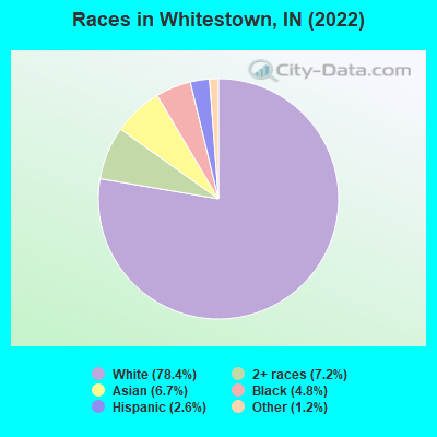
Percentage of residents living in poverty in 2022: 3.8%
(2.4% for White Non-Hispanic residents, 1.5% for Hispanic or Latino residents, 4.3% for other race residents, 9.3% for two or more races residents)
According to our research of Indiana and other state lists, there was 1 registered sex offender living in Whitestown, Indiana as of May 14, 2024. The ratio of all residents to sex offenders in Whitestown is 5,083 to 1. The ratio of registered sex offenders to all residents in this city is much lower than the state average.
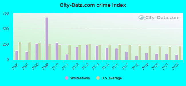
Crime rates in Whitestown by year
Type
2009
2010
2011
2012
2013
2014
2015
2016
2017
2018
2019
2020
2021
2022
Murders (per 100,000)
1 (141.0)
3 (104.6)
0 (0.0)
0 (0.0)
0 (0.0)
0 (0.0)
0 (0.0)
0 (0.0)
0 (0.0)
0 (0.0)
0 (0.0)
0 (0.0)
0 (0.0)
0 (0.0)
Rapes (per 100,000)
0 (0.0)
0 (0.0)
0 (0.0)
0 (0.0)
0 (0.0)
0 (0.0)
1 (16.7)
0 (0.0)
0 (0.0)
0 (0.0)
2 (20.4)
1 (9.8)
1 (9.3)
2 (16.8)
Robberies (per 100,000)
0 (0.0)
0 (0.0)
2 (69.4)
1 (34.2)
0 (0.0)
0 (0.0)
0 (0.0)
3 (43.8)
2 (26.8)
1 (10.7)
1 (10.2)
2 (19.5)
0 (0.0)
2 (16.8)
Assaults (per 100,000)
1 (141.0)
1 (34.9)
2 (69.4)
9 (308.2)
19 (502.9)
22 (514.5)
28 (467.9)
29 (423.4)
12 (160.8)
5 (53.3)
19 (193.7)
18 (175.6)
11 (102.4)
12 (100.8)
Burglaries (per 100,000)
11 (1,551)
1 (34.9)
5 (173.5)
13 (445.2)
11 (291.2)
10 (233.9)
8 (133.7)
19 (277.4)
16 (214.4)
7 (74.6)
2 (20.4)
10 (97.6)
4 (37.3)
7 (58.8)
Thefts (per 100,000)
39 (5,501)
34 (1,186)
17 (589.9)
68 (2,329)
98 (2,594)
103 (2,409)
105 (1,755)
111 (1,620)
109 (1,460)
80 (852.2)
98 (999.0)
106 (1,034)
126 (1,173)
102 (856.5)
Auto thefts (per 100,000)
4 (564.2)
5 (174.4)
7 (242.9)
3 (102.7)
5 (132.3)
6 (140.3)
4 (66.8)
3 (43.8)
15 (201.0)
16 (170.4)
14 (142.7)
8 (78.0)
23 (214.2)
12 (100.8)
Arson (per 100,000)
0 (0.0)
0 (0.0)
0 (0.0)
0 (0.0)
0 (0.0)
0 (0.0)
0 (0.0)
0 (0.0)
0 (0.0)
0 (0.0)
0 (0.0)
0 (0.0)
0 (0.0)
0 (0.0)
City-Data.com crime index
684.1
280.1
89.9
204.5
235.3
226.8
191.8
185.5
129.7
66.8
110.9
103.2
94.6
85.1
The City-Data.com crime index weighs serious crimes and violent crimes more heavily. Higher means more crime, U.S. average is 246.1. It adjusts for the number of visitors and daily workers commuting into cities.
Latest news from Whitestown, IN collected exclusively by city-data.com from local newspapers, TV, and radio stations
Ancestries: American (29.4%), German (15.3%), English (10.0%), Irish (5.7%), European (3.8%), Italian (1.7%).
Current Local Time: EST time zone
Elevation: 940 feet
Land area: 0.26 square miles.
Population density: 46,815 people per square mile (very high).
882 residents are foreign born (4.7% Asia, 1.4% Europe, 1.3% Latin America).
This town:
8.3%
Indiana:
5.6%
Median real estate property taxes paid for housing units with mortgages in 2022: $2,772 (0.8%) Median real estate property taxes paid for housing units with no mortgage in 2022: $2,947 (0.7%)
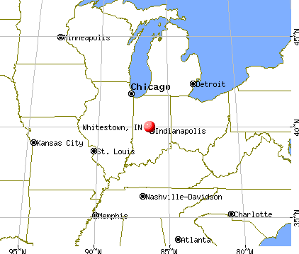
Nearest city with pop. 50,000+: Indianapolis, IN (17.6 miles , pop. 781,870).
Nearest city with pop. 1,000,000+: Chicago, IL (145.4 miles , pop. 2,896,016).
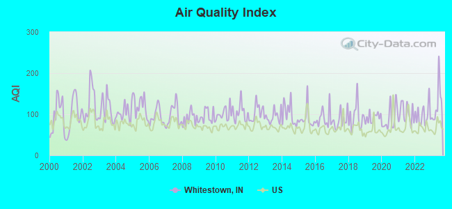
Air Quality Index (AQI) level in 2023 was 125. This is significantly worse than average.
City:
125
U.S.:
73
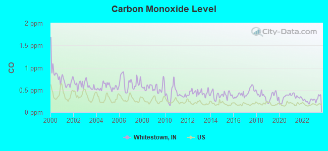
Carbon Monoxide (CO) [ppm] level in 2023 was 0.317. This is worse than average.Closest monitor was 14.2 miles away from the city center.
City:
0.317
U.S.:
0.251
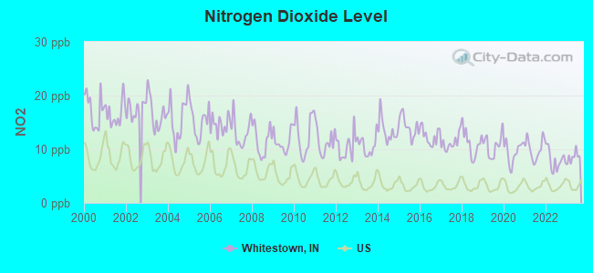
Nitrogen Dioxide (NO2) [ppb] level in 2023 was 8.56. This is significantly worse than average.Closest monitor was 15.4 miles away from the city center.
City:
8.56
U.S.:
5.11
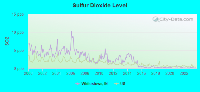
Sulfur Dioxide (SO2) [ppb] level in 2023 was 0.165. This is significantly better than average.Closest monitor was 8.6 miles away from the city center.
City:
0.165
U.S.:
1.515
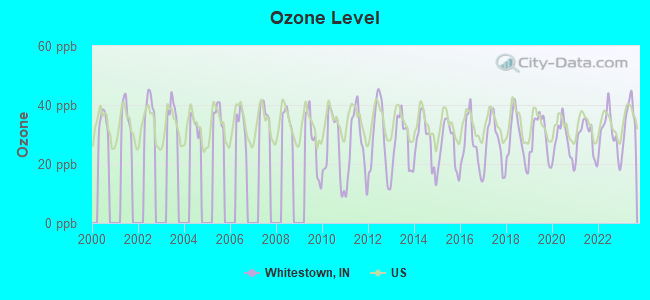
Ozone [ppb] level in 2023 was 35.0. This is about average.Closest monitor was 2.7 miles away from the city center.
City:
35.0
U.S.:
33.3
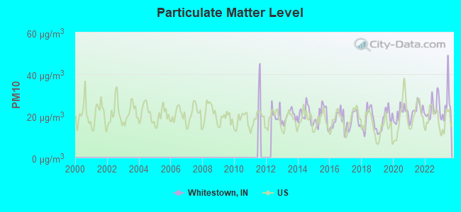
Particulate Matter (PM10) [µg/m3] level in 2023 was 25.4. This is worse than average.Closest monitor was 13.2 miles away from the city center.
City:
25.4
U.S.:
19.2
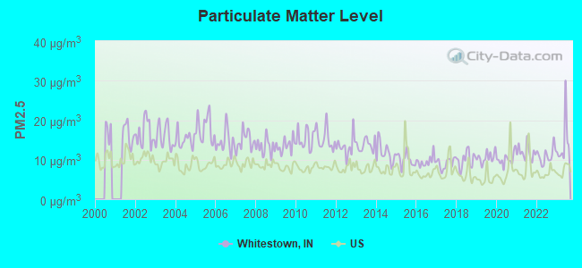
Particulate Matter (PM2.5) [µg/m3] level in 2023 was 14.2. This is significantly worse than average.Closest monitor was 14.8 miles away from the city center.
City:
14.2
U.S.:
8.1
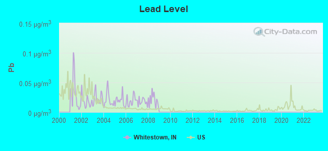
Lead (Pb) [µg/m3] level in 2008 was 0.0206. This is significantly worse than average.Closest monitor was 15.4 miles away from the city center.
City:
0.0206
U.S.:
0.0093
Tornado activity:
Whitestown-area historical tornado activity is slightly above Indiana state average. It is 121% greater than the overall U.S. average.
On 4/11/1965, a category F4 (max. wind speeds 207-260 mph) tornado 21.0 miles away from the Whitestown town center killed 28 peopleand injured 123 peopleand causedbetween $5,000,000 and $50,000,000 in damages.
On 5/14/1972, a category F4 tornado 21.0 miles away from the town center injured 20 peopleand causedbetween $50,000 and $500,000 in damages.
Earthquake activity:
Whitestown-area historical earthquake activity is significantly above Indiana state average. It is 79% greater than the overall U.S. average.
On 4/18/2008 at 09:36:59, a magnitude 5.4 (5.1 MB, 4.8 MS, 5.4 MW, 5.2 MW, Class: Moderate, Intensity: VI - VII) earthquake occurred 135.0 miles away from the city center On 4/18/2008 at 09:36:59, a magnitude 5.2 (5.2 MW, Depth: 8.9 mi) earthquake occurred 135.0 miles away from Whitestown center On 6/10/1987 at 23:48:54, a magnitude 5.1 (4.9 MB, 4.4 MS, 4.6 MS, 5.1 LG) earthquake occurred 115.7 miles away from Whitestown center On 7/27/1980 at 18:52:21, a magnitude 5.2 (5.1 MB, 4.7 MS, 5.0 UK, 5.2 UK) earthquake occurred 178.8 miles away from Whitestown center On 6/18/2002 at 17:37:15, a magnitude 5.0 (4.3 MB, 4.6 MW, 5.0 LG) earthquake occurred 158.9 miles away from the city center On 4/18/2008 at 15:14:16, a magnitude 4.8 (4.5 MB, 4.8 MW, 4.6 MW, Class: Light, Intensity: IV - V) earthquake occurred 132.4 miles away from the city center Magnitude types: regional Lg-wave magnitude (LG), body-wave magnitude (MB), surface-wave magnitude (MS), moment magnitude (MW)
Natural disasters:
The number of natural disasters in Boone County (14) is near the US average (15). Major Disasters (Presidential) Declared: 9 Emergencies Declared: 4
Causes of natural disasters: Storms: 6, Floods: 5, Tornadoes: 4, Winter Storms: 3, Snowstorms: 2, Blizzard: 1, Hurricane: 1, Ice Storm: 1, Snow: 1, Other: 1 (Note: some incidents may be assigned to more than one category).
Hospitals and medical centers near Whitestown:
ZIONSVILLE MEADOWS (Nursing Home, about 5 miles away; ZIONSVILLE, IN)
COUNTRYSIDE HEALTHCARE CENTER (Nursing Home, about 6 miles away; LEBANON, IN)
HICKORY CREEK AT LEBANON (Nursing Home, about 6 miles away; LEBANON, IN)
KINDRED TRANSITIONAL CARE AND REHAB-PARKWOOD (Nursing Home, about 8 miles away; LEBANON, IN)
PARKWOOD HEALTHCARE CENTER (Nursing Home, about 8 miles away; LEBANON, IN)
INDIANA ORTHOPAEDIC HOSPITAL Acute Care Hospitals (about 8 miles away; INDIANAPOLIS, IN)
ST VINCENT NEW HOPE INC (Hospital, about 8 miles away; INDIANAPOLIS, IN)
Amtrak station near Whitestown:
19 miles: INDIANAPOLIS (350 S. ILLINOIS ST.) . Services: ticket office, partially wheelchair accessible, public payphones, full-service food facilities, free short-term parking, paid long-term parking, call for car rental service, taxi stand, intercity bus service.
Colleges/universities with over 2000 students nearest to Whitestown:
Churches in Whitestown include: Ebenezer Baptist Church (A), Saint Marks Lutheran Church (B), Whitestown United Methodist Church (C). Display/hide their locations on the map
Boone County has a predicted average indoor radon screening level greater than 4 pCi/L (pico curies per liter) - Highest Potential
Average household size:
This town:
2.7 people
Indiana:
2.5 people
Percentage of family households:
This town:
73.5%
Whole state:
66.9%
Percentage of households with unmarried partners:
This town:
8.1%
Whole state:
6.9%
Likely homosexual households (counted as self-reported same-sex unmarried-partner households)
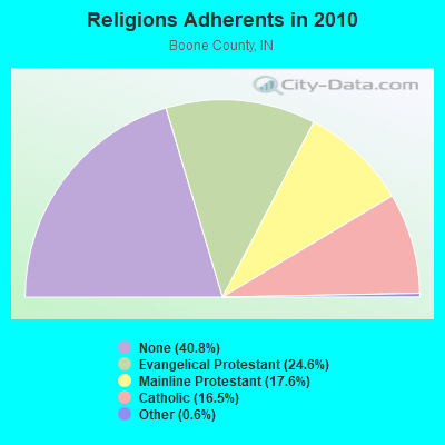
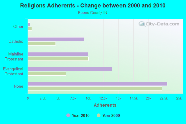
Religion statistics for Whitestown, IN (based on Boone County data)
Religion
Adherents
Congregations
Evangelical Protestant
13,919
36
Mainline Protestant
9,955
22
Catholic
9,333
2
Other
340
3
None
23,093
-
Source: Clifford Grammich, Kirk Hadaway, Richard Houseal, Dale E.Jones, Alexei Krindatch, Richie Stanley and Richard H.Taylor. 2012. 2010 U.S.Religion Census: Religious Congregations & Membership Study. Association of Statisticians of American Religious Bodies. Jones, Dale E., et al. 2002. Congregations and Membership in the United States 2000. Nashville, TN: Glenmary Research Center. Graphs represent county-level data
MW07037B, 5930 E. Rd. 750 S. (Lat: 39.932528 Lon: -86.355833), Type: Tower, Structure height: 76.2 m, Overall height: 77.4 m, Call Sign: WQPW415, Licensee ID: L00127664, Assigned Frequencies: 19375.0 MHz, 19525.0 MHz, 19375.0 MHz, 19525.0 MHz, 19375.0 MHz, 19525.0 MHz, 19375.0 MHz, 19525.0 MHz, 19375.0 MHz, 19525.0 MHz... (+6 more), Grant Date: 08/29/2012, Expiration Date: 08/29/2022, Cancellation Date: 02/19/2014, Certifier: Dan Menser, Registrant: T-Mobile License LLC, 12920 Se 38th Street, Bellevue, WA 98006, Phone: (425) 383-8401, Fax: (425) 383-4040, Email:
IN33XC028, County Road 650n And County Road 200s (Lat: 40.012111 Lon: -86.366444), Type: Gtower, Structure height: 90.2 m, Overall height: 91.1 m, Call Sign: WQQH390, Assigned Frequencies: 10855.0 MHz, Grant Date: 12/11/2012, Expiration Date: 12/11/2022, Cancellation Date: 12/08/2022, Certifier: David Werblow, Registrant: T-Mobile Usa Inc, 12920 Se 38th St, Bellevue, WA 98006, Phone: (425) 383-8401, Fax: (425) 383-4840, Email:
WHITESTOWN, Whitestown, 8505 E Cr 400 S (Lat: 39.983028 Lon: -86.307611), Type: Mtower, Structure height: 34.8 m, Overall height: 36.6 m, Call Sign: WQZJ304, Assigned Frequencies: 6404.79 MHz, 6404.79 MHz, 6404.79 MHz, 6404.79 MHz, 6404.79 MHz, 6404.79 MHz, 6404.79 MHz, 6404.79 MHz, 6256.54 MHz, 6256.54 MHz... (+14 more), Grant Date: 06/05/2017, Expiration Date: 06/05/2027, Certifier: John Kuklinski, Registrant: Duke Energy Business Services, LLC, 1000 E Main Street, Plainfield, IN 46168, Phone: (317) 838-2443, Email:
CCI 829072, 341 S. Peters Street (Mw07256a) (Lat: 39.994083 Lon: -86.342361), Type: Mtower, Structure height: 57.9 m, Overall height: 59.1 m, Call Sign: WRTC542, Assigned Frequencies: 11075.0 MHz, 18060.0 MHz, 11075.0 MHz, 18060.0 MHz, 11075.0 MHz, 18060.0 MHz, 11075.0 MHz, 18060.0 MHz, 11075.0 MHz, 18060.0 MHz... (+22 more), Grant Date: 06/01/2022, Expiration Date: 06/01/2032, Certifier: Stephen Hon, Registrant: Micronet Communications, Inc., 812 Lexington Dr, Plano, TX 75075, Phone: (972) 422-7200, Email:
Beyond Reach, East County Rd 500 South (Lat: 39.968972 Lon: -86.367389), Type: Building, Structure height: 6.7 m, Overall height: 12.8 m, Call Sign: WRXP665, Assigned Frequencies: 23125.0 MHz, 23125.0 MHz, 23125.0 MHz, 23125.0 MHz, 23125.0 MHz, 23125.0 MHz, 23125.0 MHz, 23125.0 MHz, 23125.0 MHz, 23125.0 MHz, Grant Date: 06/06/2023, Expiration Date: 06/06/2033, Certifier: Stephen Hon, Registrant: Micronet Communications, Inc., 812 Lexington Dr, Plano, TX 75075, Phone: (972) 422-7200, Email:
WHITESTOWN, 2 Mi Se Of (Lat: 39.982806 Lon: -86.307778), Type: Tower, Structure height: 30.5 m, Call Sign: WGV79, Assigned Frequencies: 6755.00 MHz, Grant Date: 03/04/2011, Expiration Date: 05/14/2021, Cancellation Date: 06/28/2019, Certifier: Richard A Donaldson, Registrant: Duke Energy Business Services, LLC, 401 South College Street, Charlotte, NC 28201-1008, Phone: (317) 838-1032, Email:
Aircraft: CESSNA 150G (Category: Land, Seats: 2, Weight: Up to 12,499 Pounds, Speed: 90 mph), Engine: CONT MOTOR 0-200 SERIES (100 HP) (4 Cycle) N-Number: 3922J, N3922J, N-3922J, Serial Number: 15065222, Airworthiness Date: 09/30/1966, Certificate Issue Date: 05/18/2018 Registrant (Individual): Thomas N Pettit, 6259 Dusty Laurel Dr, Whitestown, IN 46075 Deregistered:Cancel Date: 10/18/2013
Aircraft: TAYLORCRAFT BC12-D (Category: Land, Seats: 2, Weight: Up to 12,499 Pounds, Speed: 78 mph), Engine: CONT MOTOR A&C65 SERIES (65 HP) (Reciprocating) N-Number: 44170, N44170, N-44170, Serial Number: 9970, Year manufactured: 1946, Airworthiness Date: 08/05/1955, Certificate Issue Date: 03/07/1991 Registrant (Individual): William R Heine, 1533 N Us 421, Whitestown, IN 46075
Aircraft: SEIPLE LARRY W HARVEY-IV (Category: Land, Seats: 2, Weight: Up to 12,499 Pounds), Engine: LYCOMING 0-320 SERIES (180 HP) (Reciprocating) N-Number: 737RV, N737RV, N-737RV, Serial Number: 737, Year manufactured: 1995, Airworthiness Date: 09/27/1996, Certificate Issue Date: 01/16/2015 Registrant (Individual): Mark A Balaska, 5783 New Hope Blvd, Whitestown, IN 46075
Aircraft: AERONCA 7AC (Category: Land, Seats: 2, Weight: Up to 12,499 Pounds, Speed: 90 mph), Engine: CONT MOTOR A&C65 SERIES (65 HP) (Reciprocating) N-Number: 82418, N82418, N-82418, Serial Number: 7AC-1051, Year manufactured: 1946, Certificate Issue Date: 12/20/1984 Registrant (Individual): Gene R Hollingsworth, 7388e E 550 S, Whitestown, IN 46075
Aircraft: FLIGHTSTAR INC FLIGHTSTAR II (Category: Land, Seats: 2, Weight: Up to 12,499 Pounds), Engine: ROTAX 503 SERIES (52 HP) (2 Cycle) N-Number: 769W, N769W, N-769W, Serial Number: 1924, Year manufactured: 1997, Airworthiness Date: 10/25/2007 Registrant (Individual): Pending Registration, 4393 E 300 S, Whitestown, IN 46075
Home Mortgage Disclosure Act Aggregated Statistics For Year 2009 (Based on 1 partial tract)
A) FHA, FSA/RHS & VA Home Purchase Loans
C) Refinancings
Number
Average Value
Number
Average Value
LOANS ORIGINATED
1
$99,290
1
$285,790
APPLICATIONS APPROVED, NOT ACCEPTED
0
$0
0
$0
APPLICATIONS DENIED
0
$0
0
$0
APPLICATIONS WITHDRAWN
0
$0
0
$0
FILES CLOSED FOR INCOMPLETENESS
0
$0
0
$0
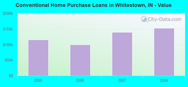
Aggregated Statistics For Year 2008 (Based on 1 partial tract)
B) Conventional Home Purchase Loans
C) Refinancings
Number
Average Value
Number
Average Value
LOANS ORIGINATED
1
$152,590
1
$136,830
APPLICATIONS APPROVED, NOT ACCEPTED
0
$0
0
$0
APPLICATIONS DENIED
0
$0
0
$0
APPLICATIONS WITHDRAWN
0
$0
0
$0
FILES CLOSED FOR INCOMPLETENESS
0
$0
0
$0
Aggregated Statistics For Year 2007 (Based on 1 partial tract)
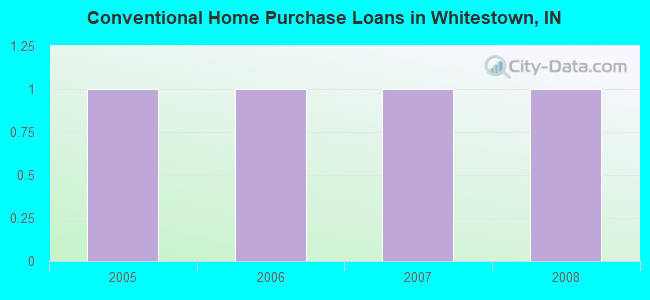
B) Conventional Home Purchase Loans
Number
Average Value
LOANS ORIGINATED
1
$139,850
APPLICATIONS APPROVED, NOT ACCEPTED
0
$0
APPLICATIONS DENIED
0
$0
APPLICATIONS WITHDRAWN
0
$0
FILES CLOSED FOR INCOMPLETENESS
0
$0
Aggregated Statistics For Year 2006 (Based on 1 partial tract)
B) Conventional Home Purchase Loans
C) Refinancings
Number
Average Value
Number
Average Value
LOANS ORIGINATED
1
$99,560
1
$110,360
APPLICATIONS APPROVED, NOT ACCEPTED
0
$0
0
$0
APPLICATIONS DENIED
0
$0
0
$0
APPLICATIONS WITHDRAWN
0
$0
0
$0
FILES CLOSED FOR INCOMPLETENESS
0
$0
0
$0
Aggregated Statistics For Year 2005 (Based on 1 partial tract)
B) Conventional Home Purchase Loans
C) Refinancings
Number
Average Value
Number
Average Value
LOANS ORIGINATED
1
$115,370
1
$155,040
APPLICATIONS APPROVED, NOT ACCEPTED
0
$0
0
$0
APPLICATIONS DENIED
0
$0
0
$0
APPLICATIONS WITHDRAWN
0
$0
0
$0
FILES CLOSED FOR INCOMPLETENESS
0
$0
0
$0
Aggregated Statistics For Year 2004 (Based on 1 partial tract)
C) Refinancings
Number
Average Value
LOANS ORIGINATED
1
$156,400
APPLICATIONS APPROVED, NOT ACCEPTED
0
$0
APPLICATIONS DENIED
0
$0
APPLICATIONS WITHDRAWN
0
$0
FILES CLOSED FOR INCOMPLETENESS
0
$0
Aggregated Statistics For Year 2003 (Based on 1 partial tract)
C) Refinancings
Number
Average Value
LOANS ORIGINATED
2
$184,025
APPLICATIONS APPROVED, NOT ACCEPTED
0
$0
APPLICATIONS DENIED
0
$0
APPLICATIONS WITHDRAWN
0
$0
FILES CLOSED FOR INCOMPLETENESS
0
$0
Aggregated Statistics For Year 2002 (Based on 1 partial tract)
C) Refinancings
Number
Average Value
LOANS ORIGINATED
1
$271,770
APPLICATIONS APPROVED, NOT ACCEPTED
0
$0
APPLICATIONS DENIED
0
$0
APPLICATIONS WITHDRAWN
0
$0
FILES CLOSED FOR INCOMPLETENESS
0
$0
Aggregated Statistics For Year 2001 (Based on 1 partial tract)
C) Refinancings
Number
Average Value
LOANS ORIGINATED
1
$212,450
APPLICATIONS APPROVED, NOT ACCEPTED
0
$0
APPLICATIONS DENIED
0
$0
APPLICATIONS WITHDRAWN
0
$0
FILES CLOSED FOR INCOMPLETENESS
0
$0
Aggregated Statistics For Year 1999 (Based on 1 partial tract)
Detailed HMDA statistics for the following Tracts:8106.01
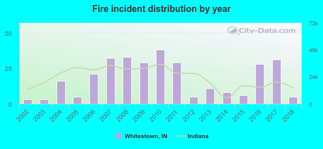
2002 - 2018 National Fire Incident Reporting System (NFIRS) incidents
Based on the data from the years 2002 - 2018 the average number of fire incidents per year is 18. The highest number of fire incidents - 38 took place in 2010, and the least - 3 in 2002. The data has a rising trend.
When looking into fire subcategories, the most reports belonged to: Outside Fires (42.6%), and Structure Fires (30.0%).
Fire incident types reported to NFIRS in Whitestown, IN


 Recent articles from our blog. Our writers, many of them Ph.D. graduates or candidates, create easy-to-read articles on a wide variety of topics.

 (17.6 miles
 Based on the data from the years 2002 - 2018 the average number of fire incidents per year is 18. The highest number of fire incidents - 38 took place in 2010, and the least - 3 in 2002. The data has a rising trend.
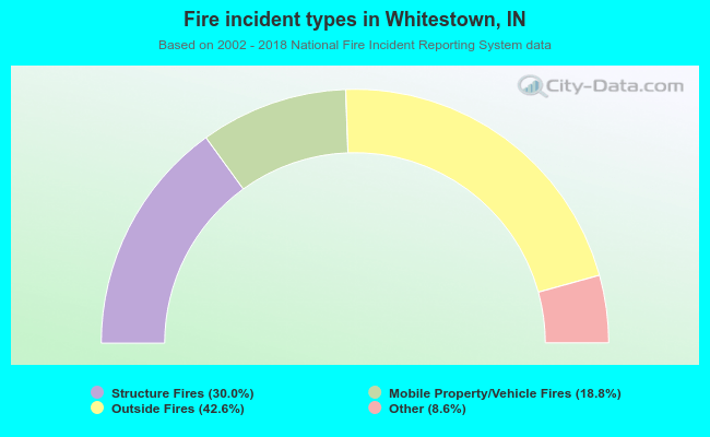 When looking into fire subcategories, the most reports belonged to: Outside Fires (42.6%), and Structure Fires (30.0%).