Please register to participate in our discussions with 2 million other members - it's free and quick! Some forums can only be seen by registered members. After you create your account, you'll be able to customize options and access all our 15,000 new posts/day with fewer ads.
Some towns are laid out in a grid; but others follow a local river or mountain ridge.
For example, Palmdale, California was established by a bunch of aerospace engineers, so the north-south streets are numbered, and the east-west avenues are lettered. Same for parts of Denver.
On the other hand, New Orleans lies inside a curve of the Mississippi River, and streets curve to follow the river. But the cross streets all fan out to stay perpendicular to the curve, so streets parallel to the river run upstream-downstream (or, uptown-downtown), and the cross streets run from the river toward Lake Pontchartrain (riverside-lakeside). North-south-east-west directions are meaningless for a uptown-downtown road that points northeast-southwest at one end and northwest-southeast at the other, or for the cross-streets that are perpendicular.
I'd imagine towns like New York or Boston have the same ideosyncracies.
I'd like to hear what YOUR town uses for directions.
Well, there's "mauka" for towards the mountains and "makai" is toward the ocean. The other two directions are filled in depending on where you're starting.
From my place, heading one way on the highway (there's only one highway so nobody really calls it anything other than "the highway" or "the road" only tourists refer to it by a number) anyway, one way on the highway is "towards Hilo" and the other direction is "towards Waimea".
This nomenclature works pretty much throughout the state, although the non Mauka/Makai directions are filled in with other areas of significance depending on where you are. If you're in downtown Honolulu, the two other directions would be 'Ewa' for out towards Ewa Beach and "Diamond Head" is the other direction which would be towards Waikiki which has Diamond Head at the far end of it.
When asking for directions, a common question will be "what's it next to?" as opposed to any address. And frequently, the answer will be something that is no longer there. "It's next to where Aloha Motors used to be" is a valid answer.
For basic sides of the islands, there's the Windward side and the Leeward side, so that gives you a basic starting point as well.
In the Florida Keys people refer to mile markers since the Overseas Highway is the only major route through the islands. Also a lot of references to ocean side vs bay side or Gulf side. Many ads for businesses mention the mile marker as part of the address.
On Cape Cod there is Bayside/Oceanside and Up=SW and Down =NE so the Lower Cape is further north than the lower Cape.
Nantucket and Martha's Vinyard East =Down West =Up
The Up/Down is relative to prevailing winds.
I would assume most river valleys there is up the valley and down the valley regardless of the direction of the valley. (Although most in the East tend to be North to south
"On a grander scale, Philadelphia was designed on a rectilinear street grid in 1682: one of the first cities in North America to use a grid system. At the urging of city founder William Penn, surveyor Thomas Holme designed a system of wide streets intersecting at right angles between the Schuylkill River to the west and the Delaware River to the east, including five squares of dedicated parkland. Penn advertised this orderly design as a safeguard against overcrowding, fire, and disease, which plagued European cities.". https://en.m.wikipedia.org/wiki/Grid_plan
Interestingly, Philadelphians walk that same grid commissioned by William Penn in 1682 today.
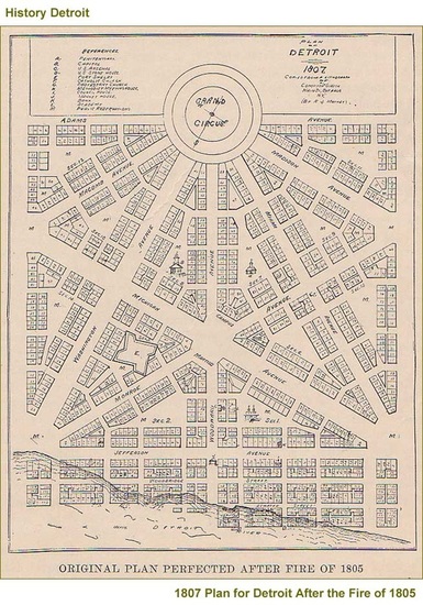
We don't really have any special directional words we use in Detroit. Obviously, there are names for areas, but I think you will find that anywhere. The dividing line is typically I-75, even though you would think it would be Woodward Avenue, which runs through the center of Downtown, Midtown, and New Center, the main business districts. Anyway, for the most part, it is just east side and west side.
Of course, Detroit was supposed to be on a triangular grid, so it can get confusing downtown. Roads aren't straight. Giving directions is difficult. I gave someone directions to the bus station last week- I had to use a building as a marker because the road curves, stops at a park, restarts with a different name, and is hard to follow if you don't know where you are going. After identifying the building, my directions were basically "Follow this road, even as it curves and appears to end. Keep going. About 6 blocks down you will get to that building. The bus station is across the street."
At each corner of the triangular grid was supposed to be a park. The triangles were supposed to repeat. Of course, this plan came well before cars, so they had no idea how difficult it would have been had they competed the entire city this way.
A close up of the plan:
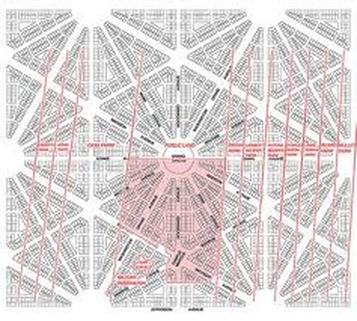
The whole plan. Only the 'pink' area was built. The pink lines are where main roads are now, obviously not following the original plan.
Savannah's urban grid has been called the most brilliant in the United States, if not the world. The city was originally laid out around 4 public squares in 1733, which had expanded to 24 squares and a large urban park (Forsyt Park) by the mid-1800s. This are today makes up the Savannah Landmark Historic District, the largest urban historic district in the country. As the city continued to grow south (away from the Savannah River) in the early 1900s, additional neighborhoods and "wards" were built along the same narrow street grid, which means Savannah of today has one of the most urban layouts of any city in the South.
Here are some links about Savannah's unique urban plan:
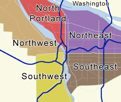
"Quad" means "four" (from Latin), but Portland, Oregon has five quadrants. The center point is the Burnside Bridge. The north/south dividing line is Burnside Street, and the east/west line is the Willamette River in the downtown area. The problem is that the river curves just north of downtown, so there's a large area that's east of the river but west of the center point on the bridge. That section is labeled "North":
Please register to post and access all features of our very popular forum. It is free and quick. Over $68,000 in prizes has already been given out to active posters on our forum. Additional giveaways are planned.
Detailed information about all U.S. cities, counties, and zip codes on our site: City-data.com.

 Please register to participate in our discussions with 2 million other members - it's free and quick! Some forums can only be seen by registered members. After you create your account, you'll be able to customize options and access all our 15,000 new posts/day with fewer ads.