Welcome to City-Data.com Forum!
U.S. CitiesCity-Data Forum Index
Go Back   City-Data Forum > U.S. Forums > General U.S.
 [Register]
Please register to participate in our discussions with 2 million other members - it's free and quick! Some forums can only be seen by registered members. After you create your account, you'll be able to customize options and access all our 15,000 new posts/day with fewer ads.
View detailed profile (Advanced) or search
site with Google Custom Search

Search Forums  (Advanced)
Reply Start New Thread
 
Old 02-17-2009, 03:28 PM
 
93,414 posts, read 124,120,588 times
Reputation: 18273

Advertisements

Elmira, NY
http://www.cityofelmira.net/map/mapitems/districts_council.gif (broken link)

1st district-Westside
2nd district-Eastside
3rd and 4th districts-Northside
5th and 6th districts-Southside

Last edited by ckhthankgod; 02-17-2009 at 03:43 PM..
Reply With Quote Quick reply to this message

 
Old 02-17-2009, 04:07 PM
 
Location: Cleveland
3,070 posts, read 11,928,797 times
Reputation: 998
Lorain, OH
http://www.cityoflorain.org/images/ward-map2000.gif (broken link)
Wards
1) Eastside
2) Downtown/Eastside/Central Lorain
3) Central Lorain/Westside
4) South Central/SW
5) South Central/South Lorain
6) South Lorain/SE/Steel Mills
7) Westside
8) SW Lorain
Reply With Quote Quick reply to this message
 
Old 02-17-2009, 06:02 PM
 
812 posts, read 4,085,266 times
Reputation: 389
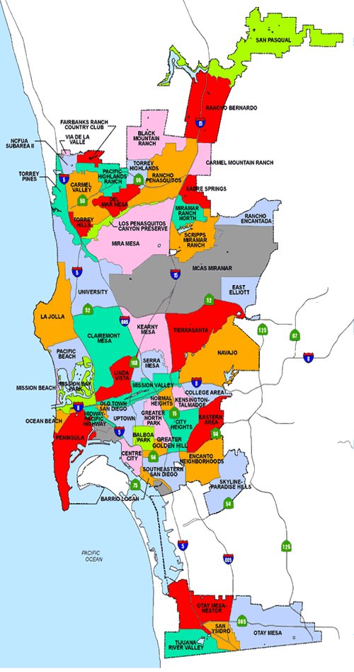
This map tends to pick out some areas that most locals haven't heard of/names they'd never use, and also jumbles together some areas that locals would refer to separately, especially closer to downtown, the suburbs are pretty good... think of it more as a "district map" over a "neighborhood map" for the inner city areas, I suppose. Either way, it's about the best I can find right now.


San Diego:
Reply With Quote Quick reply to this message
 
Old 02-17-2009, 06:22 PM
 
Location: West Michigan
12,083 posts, read 38,868,928 times
Reputation: 17006
Let's see now. Southside, Northend, Westlake, wesco, SSB, and Admiral.


OK; I made all that crap up.
here is my ENTIRE town. No neighborhood divisions here at all, just plain old Scottville. Not big enough to divide up really.
Attached Thumbnails
Map of neighborhoods in your city......-scottville.jpg  
Reply With Quote Quick reply to this message
 
Old 02-17-2009, 06:29 PM
 
Location: Back home in Kaguawagpjpa.
1,990 posts, read 7,635,939 times
Reputation: 1082
Rach, beat me to the punch ( like always) but I've found a better map of Queens! Who ever finds Flushing, gets a cookie.

Map of neighborhoods in your city......-map_boundaries2.gif
Reply With Quote Quick reply to this message
 
Old 02-17-2009, 07:44 PM
 
1,084 posts, read 3,871,158 times
Reputation: 348
i live in the flagami area, this i just the city of Miami, not the whole county.

http://www.uwec.edu/freitard/GroupAndMinority/Miami/Images/district%20map.gif (broken link)
Reply With Quote Quick reply to this message
 
Old 02-17-2009, 11:20 PM
 
Location: Connecticut
527 posts, read 1,282,452 times
Reputation: 949
Reply With Quote Quick reply to this message
 
Old 02-18-2009, 02:00 AM
 
3,635 posts, read 10,753,564 times
Reputation: 1922
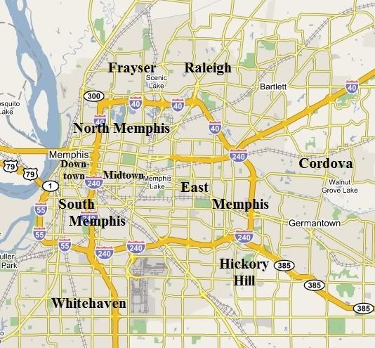
I couldn't find one so I made one. These aren't the neighborhoods, but they're the main districts. All the bolded names are in the city, Bartlett & Germantown are suburbs.

Reply With Quote Quick reply to this message
 
Old 02-18-2009, 04:46 AM
 
Location: New England & The Maritimes
2,114 posts, read 4,919,524 times
Reputation: 1114
I couldn't fit a map of neighborhoods of my town because there is no official kind of division other than voting districts which really doesn't mean anything anyways. Here is a map I found. I might add in my own neighborhood names on it if I can think of enough that people use.


note: there is no border with Melrose. that should say Stoneham. There are probably other mistakes I just haven't noticed yet.
Reply With Quote Quick reply to this message
 
Old 02-18-2009, 04:52 AM
 
Location: New England & The Maritimes
2,114 posts, read 4,919,524 times
Reputation: 1114
Here is one of the Halifax Regional Municipality in Nova Scotia. Although, the only area that is really "Halifax" is what says "Halifax Peninsula" and maybe "Halifax Mainland", "Clayton Park", "Spryfield", and "Fairview. Other than that, these were all separate towns until fairly recently.

Reply With Quote Quick reply to this message
Please register to post and access all features of our very popular forum. It is free and quick. Over $68,000 in prizes has already been given out to active posters on our forum. Additional giveaways are planned.

Detailed information about all U.S. cities, counties, and zip codes on our site: City-data.com.


Reply
Please update this thread with any new information or opinions. This open thread is still read by thousands of people, so we encourage all additional points of view.

Quick Reply
Message:


Over $104,000 in prizes was already given out to active posters on our forum and additional giveaways are planned!

Go Back   City-Data Forum > U.S. Forums > General U.S.

All times are GMT -6.

© 2005-2024, Advameg, Inc. · Please obey Forum Rules · Terms of Use and Privacy Policy · Bug Bounty

City-Data.com - Contact Us - Archive 1, 2, 3, 4, 5, 6, 7, 8, 9, 10, 11, 12, 13, 14, 15, 16, 17, 18, 19, 20, 21, 22, 23, 24, 25, 26, 27, 28, 29, 30, 31, 32, 33, 34, 35, 36, 37 - Top