Mohawk, Tennessee
Submit your own pictures of this place and show them to the world
- OSM Map
- General Map
- Google Map
- MSN Map

| Males: 1,615 | |
| Females: 1,634 |
| Median resident age: | 37.1 years |
| Tennessee median age: | 35.9 years |
Zip code: 37810
| Mohawk: | $45,712 |
| TN: | $65,254 |
Estimated per capita income in 2022: $21,376 (it was $12,878 in 2000)
Mohawk CCD income, earnings, and wages data
Estimated median house or condo value in 2022: $169,532 (it was $66,300 in 2000)
| Mohawk: | $169,532 |
| TN: | $284,800 |
Detailed information about poverty and poor residents in Mohawk, TN


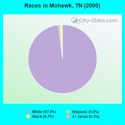
- 3,04497.9%White alone
- 311.0%Hispanic
- 210.7%Black alone
- 100.3%Two or more races
- 20.06%American Indian alone
- 10.03%Native Hawaiian and Other
Pacific Islander alone - 10.03%Other race alone
Races in Mohawk detailed stats: ancestries, foreign born residents, place of birth
According to our research of Tennessee and other state lists, there were 3 registered sex offenders living in Mohawk, Tennessee as of June 08, 2024.
The ratio of all residents to sex offenders in Mohawk is 1,083 to 1.
The ratio of registered sex offenders to all residents in this city is much lower than the state average.
 Recent articles from our blog. Our writers, many of them Ph.D. graduates or candidates, create easy-to-read articles on a wide variety of topics.
Current Local Time: EST time zone
Elevation: 1086 feet
Land area: 61.8 square miles.
Population density: 53 people per square mile (very low).

| Mohawk CCD: | 0.4% ($292) |
| Tennessee: | 0.8% ($715) |
Nearest city with pop. 50,000+: Johnson City, TN  (40.6 miles , pop. 55,469).
Nearest city with pop. 200,000+: Charlotte, NC (143.1 miles , pop. 540,828).
Nearest city with pop. 1,000,000+: Chicago, IL (462.8 miles , pop. 2,896,016).
Nearest cities:
), ), ), )Latitude: 36.18 N, Longitude: 83.08 W
Area code commonly used in this area: 423

| Here: | 3.9% |
| Tennessee: | 3.0% |
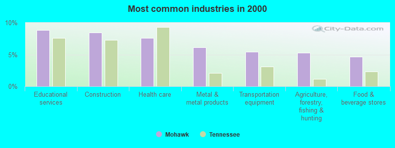
- Educational services (8.8%)
- Construction (8.4%)
- Health care (7.6%)
- Metal & metal products (6.1%)
- Transportation equipment (5.4%)
- Agriculture, forestry, fishing & hunting (5.3%)
- Food & beverage stores (4.7%)
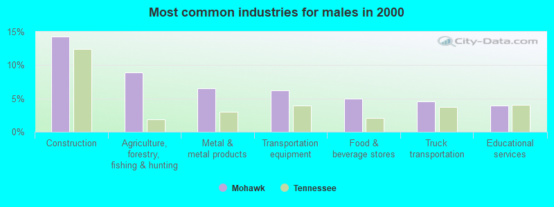
- Construction (14.3%)
- Agriculture, forestry, fishing & hunting (8.9%)
- Metal & metal products (6.5%)
- Transportation equipment (6.2%)
- Food & beverage stores (5.0%)
- Truck transportation (4.6%)
- Educational services (3.9%)
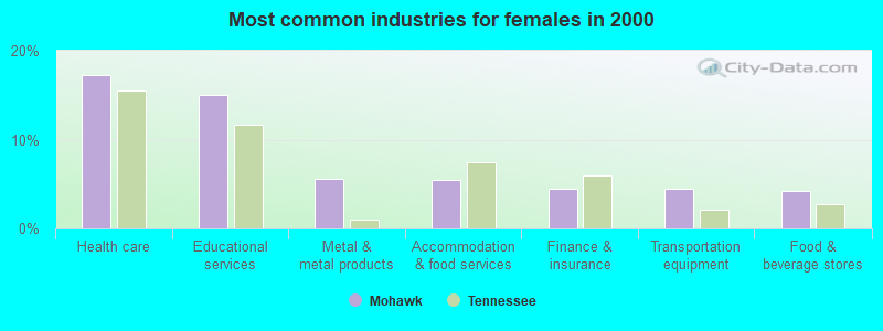
- Health care (17.3%)
- Educational services (15.1%)
- Metal & metal products (5.7%)
- Accommodation & food services (5.5%)
- Finance & insurance (4.5%)
- Transportation equipment (4.5%)
- Food & beverage stores (4.3%)
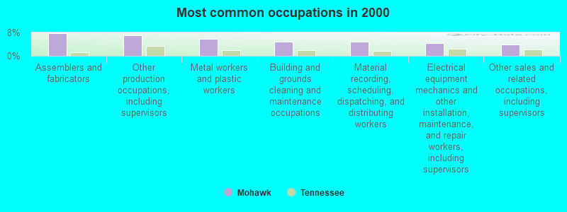
- Assemblers and fabricators (7.8%)
- Other production occupations, including supervisors (6.9%)
- Metal workers and plastic workers (5.8%)
- Building and grounds cleaning and maintenance occupations (4.8%)
- Material recording, scheduling, dispatching, and distributing workers (4.8%)
- Electrical equipment mechanics and other installation, maintenance, and repair workers, including supervisors (4.3%)
- Other sales and related occupations, including supervisors (4.0%)
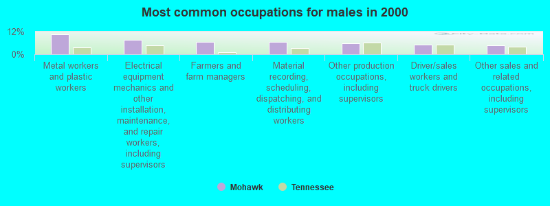
- Metal workers and plastic workers (10.4%)
- Electrical equipment mechanics and other installation, maintenance, and repair workers, including supervisors (7.7%)
- Farmers and farm managers (6.6%)
- Material recording, scheduling, dispatching, and distributing workers (6.6%)
- Other production occupations, including supervisors (5.9%)
- Driver/sales workers and truck drivers (5.3%)
- Other sales and related occupations, including supervisors (4.6%)
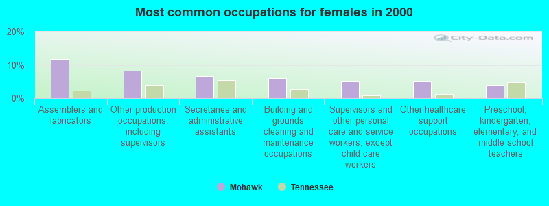
- Assemblers and fabricators (11.8%)
- Other production occupations, including supervisors (8.2%)
- Secretaries and administrative assistants (6.7%)
- Building and grounds cleaning and maintenance occupations (6.0%)
- Supervisors and other personal care and service workers, except child care workers (5.1%)
- Other healthcare support occupations (5.1%)
- Preschool, kindergarten, elementary, and middle school teachers (3.9%)
Average climate in Mohawk, Tennessee
Based on data reported by over 4,000 weather stations


(lower is better)
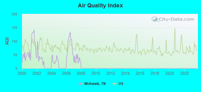
Air Quality Index (AQI) level in 2007 was 31.9. This is significantly better than average.
| City: | 31.9 |
| U.S.: | 72.6 |
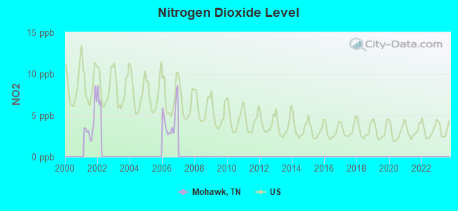
Nitrogen Dioxide (NO2) [ppb] level in 2006 was 4.41. This is about average. Closest monitor was 9.3 miles away from the city center.
| City: | 4.41 |
| U.S.: | 5.11 |
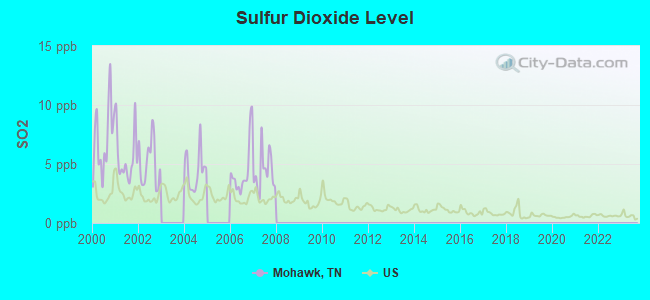
Sulfur Dioxide (SO2) [ppb] level in 2007 was 4.34. This is significantly worse than average. Closest monitor was 9.3 miles away from the city center.
| City: | 4.34 |
| U.S.: | 1.51 |
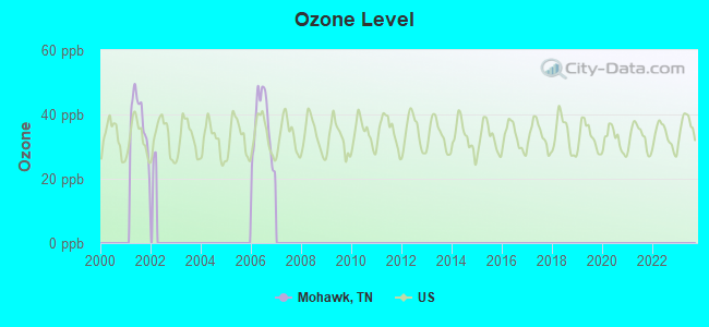
Ozone [ppb] level in 2006 was 36.4. This is about average. Closest monitor was 9.3 miles away from the city center.
| City: | 36.4 |
| U.S.: | 33.3 |
Tornado activity:
Mohawk-area historical tornado activity is significantly below Tennessee state average. It is 64% smaller than the overall U.S. average.
On 3/12/1967, a category F2 (max. wind speeds 113-157 mph) tornado 9.5 miles away from the Mohawk place center killed one person and injured 5 people and caused between $50,000 and $500,000 in damages.
On 3/11/1963, a category F2 tornado 11.0 miles away from the place center killed one person and injured one person and caused between $50,000 and $500,000 in damages.
Earthquake activity:
Mohawk-area historical earthquake activity is significantly above Tennessee state average. It is 47% greater than the overall U.S. average.On 8/9/2020 at 12:07:37, a magnitude 5.1 (5.1 MW, Depth: 4.7 mi, Class: Moderate, Intensity: VI - VII) earthquake occurred 112.3 miles away from the city center
On 7/27/1980 at 18:52:21, a magnitude 5.2 (5.1 MB, 4.7 MS, 5.0 UK, 5.2 UK) earthquake occurred 147.8 miles away from the city center
On 11/30/1973 at 07:48:41, a magnitude 4.7 (4.7 MB, 4.6 ML, Class: Light, Intensity: IV - V) earthquake occurred 56.2 miles away from Mohawk center
On 8/23/2011 at 17:51:04, a magnitude 5.8 (5.8 MW, Depth: 3.7 mi) earthquake occurred 307.8 miles away from the city center
On 8/2/1974 at 08:52:09, a magnitude 4.9 (4.3 MB, 4.9 LG) earthquake occurred 163.2 miles away from the city center
On 4/29/2003 at 08:59:39, a magnitude 4.9 (4.4 MB, 4.6 MW, 4.9 LG) earthquake occurred 185.4 miles away from the city center
Magnitude types: regional Lg-wave magnitude (LG), body-wave magnitude (MB), local magnitude (ML), surface-wave magnitude (MS), moment magnitude (MW)
Natural disasters:
The number of natural disasters in Greene County (11) is smaller than the US average (15).Major Disasters (Presidential) Declared: 7
Emergencies Declared: 2
Causes of natural disasters: Floods: 7, Storms: 5, Winter Storms: 3, Flash Flood: 1, Heavy Rain: 1, Hurricane: 1, Ice Storm: 1, Landslide: 1, Mudslide: 1, Snowfall: 1, Tornado: 1, Wind: 1, Other: 1 (Note: some incidents may be assigned to more than one category).
Hospitals and medical centers near Mohawk:
- INTERIM HEALTH CARE OF EAST TENNESSEE (Home Health Center, about 12 miles away; MORRISTOWN, TN)
- FMC MORRISTOWN (Dialysis Facility, about 13 miles away; MORRISTOWN, TN)
- LAKEWAY REGIONAL HOSPITAL Acute Care Hospitals (about 13 miles away; MORRISTOWN, TN)
- SIGNATURE HEALTHCARE OF GREENEVILLE (Nursing Home, about 13 miles away; GREENEVILLE, TN)
- GREENEVILLE WEST HLTH CARE CTR (Nursing Home, about 13 miles away; GREENEVILLE, TN)
- ADVANCED HOME CARE, INC (Home Health Center, about 14 miles away; GREENEVILLE, TN)
- HERITAGE CENTER, THE (Nursing Home, about 14 miles away; MORRISTOWN, TN)
Colleges/universities with over 2000 students nearest to Mohawk:
- Walters State Community College (about 11 miles; Morristown, TN; Full-time enrollment: 4,359)
- Tusculum College (about 18 miles; Greeneville, TN; FT enrollment: 2,070)
- East Tennessee State University (about 41 miles; Johnson City, TN; FT enrollment: 12,774)
- Lincoln Memorial University (about 43 miles; Harrogate, TN; FT enrollment: 3,706)
- Northeast State Community College (about 43 miles; Blountville, TN; FT enrollment: 4,480)
- University of North Carolina at Asheville (about 49 miles; Asheville, NC; FT enrollment: 3,312)
- The University of Tennessee-Knoxville (about 51 miles; Knoxville, TN; FT enrollment: 25,483)
Public elementary/middle school in Mohawk:
- MCDONALD ELEMENTARY (Students: 420, Location: 8120 MCDONALD RD, Grades: PK-8)
Points of interest:
Notable locations in Mohawk: Darrow Mill (A), McDonald Volunteer Fire Department (B). Display/hide their locations on the map
Churches in Mohawk include: Fairview Church (A), Sinking Springs Church (B), Bible Chapel (C), Warrensburg Baptist Church (D), Warrensburg United Methodist Church (E), Beulah Church (F), Wesley Churh (G), Bewley Chapel (H), Guthrie Gap Church (I). Display/hide their locations on the map
Cemeteries: Kesterson Cemetery (1), Wisecarver Cemetery (2), Wright Cemetery (3), Lyle Cemetery (4), Bible Cemetery (5), McCorkel Cemetery (6), Courtney Cemetery (7). Display/hide their locations on the map
Lakes: Easterly Pond (A), Scruggs Pond (B). Display/hide their locations on the map
Streams, rivers, and creeks: Lollar Branch (A), Cobble Branch (B), Stullz Branch (C), Jackson Branch (D), Little Chucky Creek (E), Gray Branch (F), Fox Branch (G), Lick Creek (H), Skipper Creek (I). Display/hide their locations on the map
Drinking water stations with addresses in Mohawk and their reported violations in the past:
OLD KNOXVILLE HWY U D (Population served: 8,497, Purch surface water):Past monitoring violations:
- Monitoring, Repeat Major (TCR) - In JUL-2006, Contaminant: Coliform (TCR). Follow-up actions: St Compliance achieved (AUG-21-2006), St Public Notif requested (SEP-05-2006), St Violation/Reminder Notice (SEP-05-2006), St Public Notif received (JUN-01-2007)
| This place: | 2.5 people |
| Tennessee: | 2.5 people |
| This place: | 62.7% |
| Whole state: | 69.8% |
| This place: | 4.8% |
| Whole state: | 4.2% |
Likely homosexual households (counted as self-reported same-sex unmarried-partner households)
- Lesbian couples: 0.2% of all households
- Gay men: 0.0% of all households
| This place: | 15.6% |
| Whole state: | 13.5% |
| This place: | 6.3% |
| Whole state: | 5.8% |
For population 15 years and over in Mohawk:
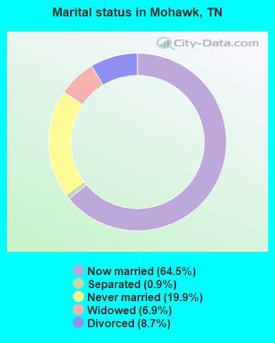
- Never married: 19.9%
- Now married: 64.5%
- Separated: 0.9%
- Widowed: 6.9%
- Divorced: 8.7%
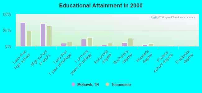
For population 25 years and over in Mohawk:
- High school or higher: 62.4%
- Bachelor's degree or higher: 8.9%
- Graduate or professional degree: 3.0%
- Unemployed: 5.9%
- Mean travel time to work (commute): 25.8 minutes
| Here: | 13.5 |
| Tennessee average: | 13.3 |
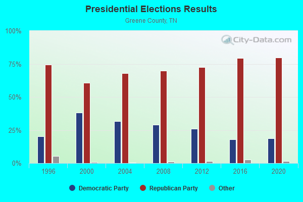
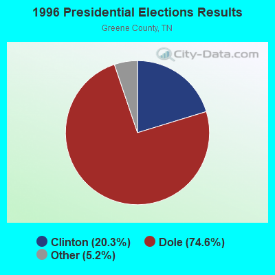
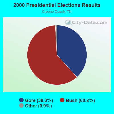

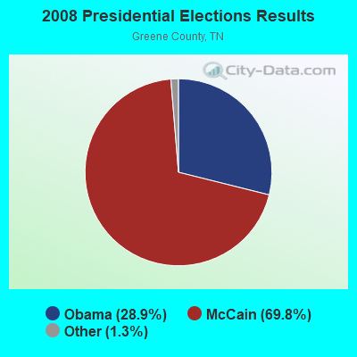

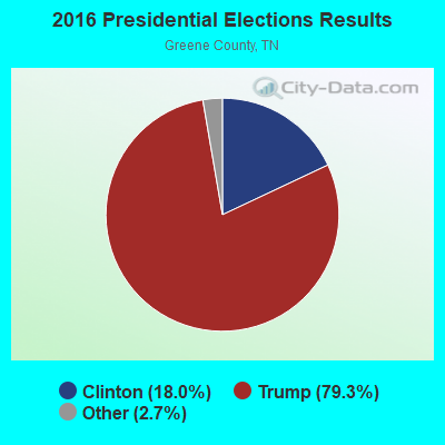
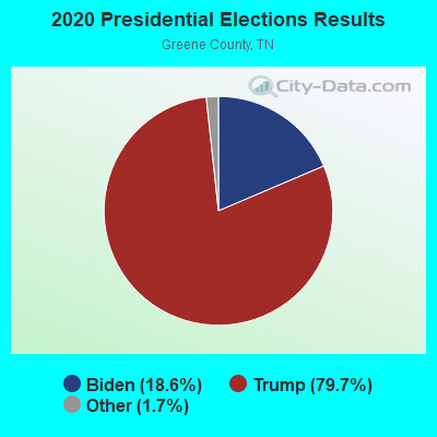
Graphs represent county-level data. Detailed 2008 Election Results
Religion statistics for Mohawk, TN (based on Greene County data)
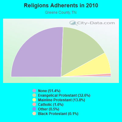

| Religion | Adherents | Congregations |
|---|---|---|
| Evangelical Protestant | 22,449 | 110 |
| Mainline Protestant | 9,496 | 74 |
| Catholic | 1,094 | 1 |
| Other | 326 | 2 |
| Black Protestant | 95 | 1 |
| None | 35,371 | - |
Food Environment Statistics:
| This county: | 1.67 / 10,000 pop. |
| Tennessee: | 1.99 / 10,000 pop. |
| Greene County: | 0.46 / 10,000 pop. |
| State: | 0.65 / 10,000 pop. |
| This county: | 6.68 / 10,000 pop. |
| Tennessee: | 5.16 / 10,000 pop. |
| This county: | 5.16 / 10,000 pop. |
| Tennessee: | 6.56 / 10,000 pop. |
| Here: | 11.3% |
| Tennessee: | 11.4% |
| Greene County: | 31.2% |
| Tennessee: | 30.2% |
| This county: | 11.9% |
| State: | 13.5% |
Strongest AM radio stations in Mohawk:
- WCRK (1150 AM; 5 kW; MORRISTOWN, TN; Owner: RADIO ACQUISITION CORP.)
- WKVL (850 AM; daytime; 50 kW; KNOXVILLE, TN; Owner: HORNE RADIO, LLC)
- WMTN (1300 AM; 5 kW; MORRISTOWN, TN)
- WFGW (1010 AM; 50 kW; BLACK MOUNTAIN, NC; Owner: BLUE RIDGE BROADCASTING CORP.)
- WLIK (1270 AM; 5 kW; NEWPORT, TN; Owner: WLIK, INC)
- WKJV (1380 AM; 25 kW; ASHEVILLE, NC; Owner: INTERNATIONAL BAPTIST OUTREACH MISSIONS)
- WGOC (640 AM; 10 kW; BLOUNTVILLE, TN; Owner: CITADEL BROADCASTING COMPANY)
- WLFJ (660 AM; daytime; 50 kW; GREENVILLE, SC; Owner: CLEAR CHANNEL BROADCASTING LICENSES, INC.)
- WPWT (870 AM; daytime; 10 kW; COLONIAL HEIGHTS, TN; Owner: INFORMATION COMMUNICATIONS CORP.)
- WHGG (1090 AM; daytime; 10 kW; KINGSPORT, TN; Owner: APPALACHIAN EDUCATIONAL COMMUNICATIO)
- WCSZ (1070 AM; 50 kW; SANS SOUCI, SC; Owner: WHYZ RADIO, L.P.)
- WKTP (1590 AM; 10 kW; JONESBOROUGH, TN; Owner: HOLSTON VALLEY BROADCASTING CORP.)
- WGRV (1340 AM; 1 kW; GREENEVILLE, TN; Owner: RADIO GREENEVILLE, INC.)
Strongest FM radio stations in Mohawk:
- WBGQ (100.7 FM; BULLS GAP, TN; Owner: CHEROKEE BROADCASTING)
- WJDT (106.5 FM; ROGERSVILLE, TN; Owner: C & S BROADCASTING)
- WMXK (94.1 FM; MORRISTOWN, TN; Owner: HORNE RADIO, LLC)
- WNPC-FM (92.9 FM; NEWPORT, TN; Owner: HARRIS BROADCASTING INC DBA WNPC INC)
- WTFM (98.5 FM; KINGSPORT, TN; Owner: HOLSTON VALLEY BROADCASTING CORP.)
- WAEZ (94.9 FM; GREENEVILLE, TN; Owner: BRISTOL BROADCASTING COMPANY, INC.)
- WMIT (106.9 FM; BLACK MOUNTAIN, NC; Owner: BLUE RIDGE BROADCASTING CORPORATION)
- WNCW (88.7 FM; SPINDALE, NC; Owner: ISOTHERMAL COMMUNITY COLLEGE)
- WIMZ-FM (103.5 FM; KNOXVILLE, TN; Owner: SOUTH CENTRAL COMM., CORP.)
- WIVK-FM (107.7 FM; KNOXVILLE, TN; Owner: CITADEL BROADCASTING COMPANY)
- WWST (102.1 FM; SEVIERVILLE, TN; Owner: JOURNAL BROADCAST CORPORATION)
- W237AR (95.3 FM; HAZELWOOD, ETC., NC; Owner: WESTERN NORTH CAROLINA PUBLIC RADIO)
- WKSF (99.9 FM; ASHEVILLE, NC; Owner: CAPSTAR TX LIMITED PARTNERSHIP)
- WPJO (99.3 FM; ELIZABETHTON, TN; Owner: BRISTOL BROADCASTING COMPANY, INC.)
- WHCB (91.5 FM; BRISTOL, TN; Owner: APPALACHIAN EDUC. COMMUNICATION CORP)
- WRZK (95.9 FM; COLONIAL HEIGHTS, TN; Owner: MURRAY COMMUNICATIONS)
- WETS-FM (89.5 FM; JOHNSON CITY, TN; Owner: EAST TENNESSEE STATE UNIVERSITY)
- WXBQ-FM (96.9 FM; BRISTOL, TN; Owner: BRISTOL BROADCASTING COMPANY, INC.)
- WQUT (101.5 FM; JOHNSON CITY, TN; Owner: CITADEL BROADCASTING COMPANY)
- WQNS (104.9 FM; WAYNESVILLE, NC; Owner: CLEAR CHANNEL BROADCASTING LICENSES, INC.)
TV broadcast stations around Mohawk:
- WASV-TV (Channel 62; ASHEVILLE, NC; Owner: MEDIA GENERAL BROADCASTING OF SOUTH CAROLINA HOLDINGS, INC.)
- WKOP-TV (Channel 15; KNOXVILLE, TN; Owner: EAST TENNESSEE PUBLIC COMMUNICATIONS CORP.)
- WVLT-TV (Channel 8; KNOXVILLE, TN; Owner: WVLT LICENSEE CORP.)
- WBIR-TV (Channel 10; KNOXVILLE, TN; Owner: GANNETT PACIFIC CORPORATION)
- WATE-TV (Channel 6; KNOXVILLE, TN; Owner: WATE, G.P.)
- WTNZ (Channel 43; KNOXVILLE, TN; Owner: RAYCOM AMERICA, INC.)
- WETP-TV (Channel 2; SNEEDVILLE, TN; Owner: EAST TENNESSEE PUBLIC COMMUNICATIONS CORP.)
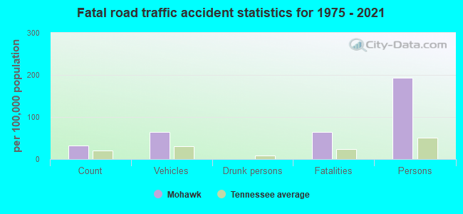
Mohawk fatal accident list:
FCC Registered Antenna Towers:
18 (See the full list of FCC Registered Antenna Towers in Mohawk)FCC Registered Microwave Towers:
1- THULA, 1095 Green Road (Lat: 36.181167 Lon: -83.054028), Type: Ltower, Structure height: 59 m, Overall height: 60.6 m, Call Sign: WQYT699,
Assigned Frequencies: 10835.0 MHz, 10915.0 MHz, Grant Date: 01/17/2017, Expiration Date: 01/17/2027, Cancellation Date: 07/11/2023, Certifier: Gregory M Romano, Registrant: Verizon, 1300 I St Nw - Suite 500 East, Washington, DC 20005, Phone: (202) 515-2453, Email:
FCC Registered Amateur Radio Licenses:
14 (See the full list of FCC Registered Amateur Radio Licenses in Mohawk)FAA Registered Aircraft:
3- Aircraft: SIXCHUTER SR7 (Category: Land, Seats: 2, Weight: Up to 12,499 Pounds), Engine: ROTAX 582SER (65 HP) (2 Cycle)
N-Number: 2601C, N2601C, N-2601C, Serial Number: 99-2230SR7X1, Year manufactured: 1999, Airworthiness Date: 09/21/2007, Certificate Issue Date: 03/14/2013
Registrant (Individual): George E Mcmullen, 240 Bays Mountain Rd, Mohawk, TN 37810 - Aircraft: HEAD BALLOONS INC AX8-88B (Category: Land, Seats: 4, Weight: Up to 12,499 Pounds), Engine: None
N-Number: 45164, N45164, N-45164, Serial Number: 203, Year manufactured: 1992, Airworthiness Date: 11/18/1992, Certificate Issue Date: 03/14/2013
Registrant (Individual): George E Mcmullen, 240 Bays Mountain Rd, Mohawk, TN 37810 - Aircraft: THUNDER BALLOONS LIMITED AX8-105 (Category: Land, Seats: 4, Weight: Up to 12,499 Pounds), Engine: None
N-Number: 936BC, N936BC, N-936BC, Serial Number: 1411, Year manufactured: 1989, Airworthiness Date: 07/07/1989, Certificate Issue Date: 04/09/1997
Registrant (Co-Owned): George E Mcmullen, 240 Bays Mountain Rd, Mohawk, TN 37810, Other Owners: Renee M Mcmullen
Deregistered: Cancel Date: 03/06/2017
2004 - 2018 National Fire Incident Reporting System (NFIRS) incidents
- Fire incident types reported to NFIRS in Mohawk, TN
- 8157.4%Structure Fires
- 4632.6%Outside Fires
- 107.1%Mobile Property/Vehicle Fires
- 42.8%Other
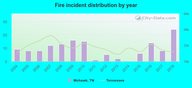 Based on the data from the years 2004 - 2018 the average number of fire incidents per year is 9. The highest number of fire incidents - 24 took place in 2018, and the least - 0 in 2014. The data has an increasing trend.
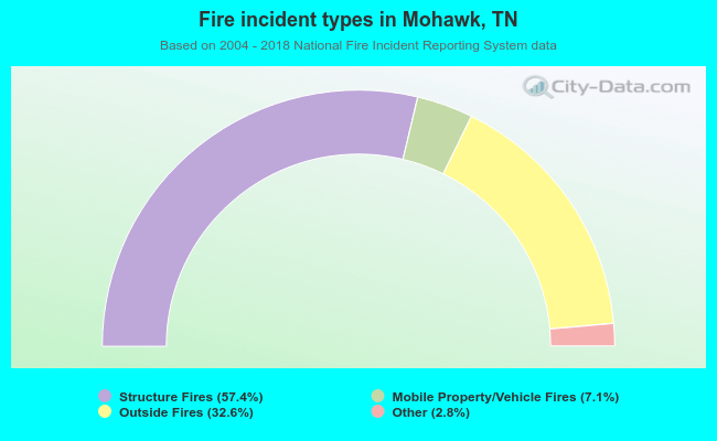 When looking into fire subcategories, the most reports belonged to: Structure Fires (57.4%), and Outside Fires (32.6%).
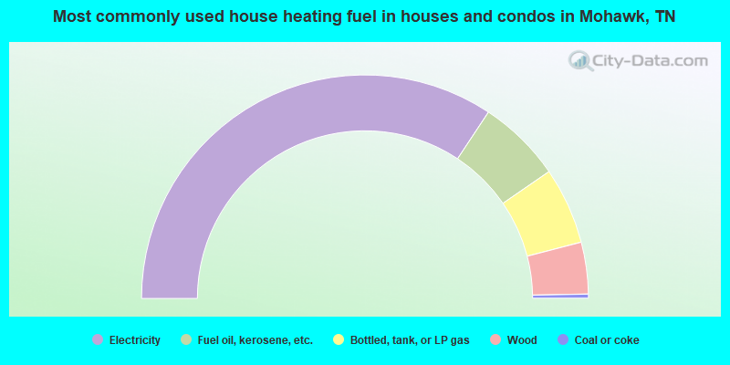
- 68.7%Electricity
- 12.2%Fuel oil, kerosene, etc.
- 11.1%Bottled, tank, or LP gas
- 7.5%Wood
- 0.6%Coal or coke
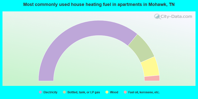
- 71.9%Electricity
- 14.9%Bottled, tank, or LP gas
- 10.2%Wood
- 3.0%Fuel oil, kerosene, etc.
Mohawk compared to Tennessee state average:
- Median house value below state average.
- Unemployed percentage below state average.
- Black race population percentage significantly below state average.
- Hispanic race population percentage significantly below state average.
- Foreign-born population percentage significantly below state average.
- Renting percentage significantly below state average.
- Length of stay since moving in significantly above state average.
- Number of rooms per house significantly below state average.
- House age significantly below state average.
- Number of college students below state average.
- Percentage of population with a bachelor's degree or higher significantly below state average.