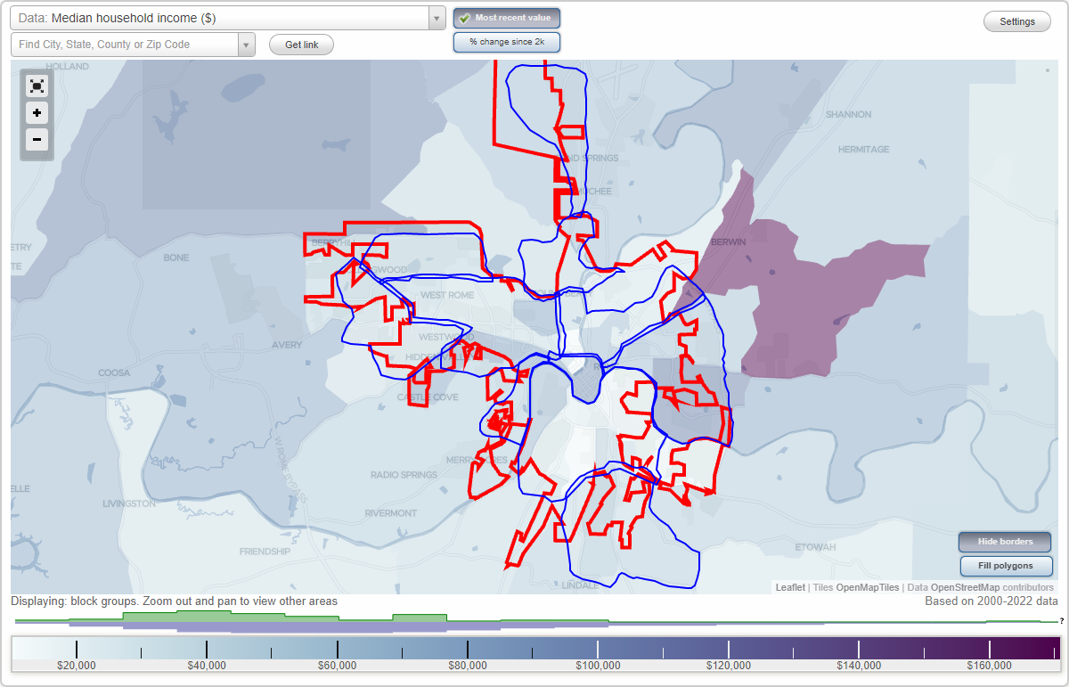
Rome, Georgia Neighborhood Map - Income, House Prices, Occupations, Boundaries
Settings
X

- City boundary
- Neighborhood boundaries
Business Search - 14 Million verified businesses
Neighborhoods:
Atlanta Junction, Downtown, Garden Lakes, Glenwood, Horseleg Estates, Huffaker, Mount Berry, Riverside, Rosemont Park, Sherwood Forest, West RomeAtlanta Junction neighborhood in Rome statistics: (Find on map)
Area: 6.982 square miles
Population: 5,185
Population density:
Median household income in 2021:
Median rent in in 2021:
Male vs Females
Median age
Average estimated value of detached houses in 2021 (62.3% of all units):
Most popular occupations of males: production occupations (20.1%); sales and office occupations (16.7%); service occupations (16.1%); construction, extraction, and maintenance occupations (9.7%); arts, design, entertainment, sports, and media occupations (6.9%); education, training, and library occupations (4.7%); business and financial operations occupations (4.2%)
Most popular occupations of females: service occupations (20.9%); sales and office occupations (20.1%); education, training, and library occupations (13.8%); production occupations (13.6%); healthcare practitioners and technical occupations (12.6%); management occupations (except farmers) (3.9%); business and financial operations occupations (3.1%)
Highways in this neighborhood: State Rte 1 (US Hwy 27, State Rte 53, US Hwy 411, Cedartown Hwy); State Rte 1 (State Rte 20, US Hwy 27, State Rte 53, E 2nd Ave); State Rte 20 (US Hwy 411); State Rte 1 (State Rte 20, US Hwy 27, Turner McCall Blvd); State Rte 101 (Dean Ave, Rockmart Rd SE); Cartersville Hwy SE (State Rte 20, US Hwy 411); State Rte 101 (2nd Ave); State Rte 101 (Rockmart Hwy SE).
Roads and streets: Cave Spring Rd SW; Lindale Rd (Maple St, Maple Ave SW); E 12th St; Branham Ave; S Broad St; Cedar Ave; Blacks Bluff Rd SW; Callier Springs Rd SE; E 11th St; Dodd Blvd SE; E 14th St; E 19th St; E 20th St; E 9th St; Pennington Ave; E 10th St; E 8th St; Roy St; Flannery St; Darlington Dr SW; Park Rd SW; E 15th St; Riverbend Dr; Agnes St SW; Nixon Ave; Pinehurst Dr SE; Hardy Ave; E 17th St; Crane St; E 18th St; Turnbull Dr; Myrtle St; Cooper Dr; Cherokee St; Vinings Dr; E Main St; E 7th St; Wilson Ave; Hull Ave; Holmes Rd; E 16th St; Highland Ave; Riverview Rd; E 13th St; Lookout Cir; Hemlock St; Grover St; Cave Spring St SW; Blanch Ave; S Blanch Ave; Cheney St; Walnut Ave; Pine Park Dr SE; Harper Ave; Woodland St; Brown St; W Glover St; Collinwood Rd; Porter St; Cooper Dr SE; Laporte St; Virginia Cir; McLin St; Lenox Cir; Evergreen St; Olmstead St; Spring Creek St; Crescent Ave; Mc Henry Dr SW; River Ave; Haley Dr; Vocational Dr; Silver Ave; Line St; Darlington Way; High St; Townview Rd; Greenbriar Ln; E Glover St; Noble St; Butler St; Worsham St; W Forest St; Willingham St; Lee Ave; Marvin Crowe Dr SW; O Neill St; Crawford St; Etowah Ter; S McLin St; Lombardy Way; Pollock St; Benvenue Dr; Clover St; Notasulga Dr; Hicks Rd; Webb St; King St; Berry St; Coral Ave; Matelda Dr (Matilda Dr); Lookout Ave; Briarcliff Rd; Overhill Rd; Woodcrest Dr; Orlystus Dr; Busby Ln; Clark Dr; Coosa St; Peachtree St; Mc Ghee St; E 6th St; Mulberry St; W Main St; Vinings Ct; Charles St; Moultrie Ln; Gables Dr SE; Park Blvd; Tiger Flower Dr SE; Miller Dr; Wimpee St; Joe Louis Blvd SE; Klassing St; Watson Dr SW; Morningside Dr SW; Landrum Pl; Holiday Dr; Silver St; Grove St; Eastwood Ln SE; Strand St; Commerce Ct; Hosea Ave; Wheeler St; Merrell Ave; Jervis St; Vasser Dr SE; Terrace Dr; E 6th St SW; Cotton Ave; Elberta St; E Boundary St SE; Summit; Co Rd 307; Mason Ln; Lincoln St; Roswell Ave; Margaret St; Club Dr; Higgins St; Wallace Dr; Grace Dr SE; Queen; Tennessee Ave; E Ridge Ct; N Mc Lin St; Clifford St; Orchid Pl; Mayfield St; Campbell St; Lyte Ave; Old Lindale Rd; Carver Ave; Skyview Ter; Sunset Dr SE; Crestview Ln SE; Bobo St; Castleberry St; Hopewell St; Cobb Dr; Beal Ln; Rambler Rd SE; Denney Dr; Camp Ln; E Forest St; Moore Ave SW; Hill St; Plant St; Cantrell Dr; Cantrell St; Archer St; Brennel Rd; Richland Ct; Cole St; Townview Pl; Mary St; Kentucky Ave; Holder St; Alto St; Sunrise Dr; N Pennington Ave; Morningside Dr; Maurice Culberson Dr SW; Park Ct; Co Rd 307 (Swlumber St); Mumford St; Fair St; Rutledge St; Harbin Aly SW; Club View Dr SE; Milco Pl SE; Maple Rd; Chulio Rd SE; Daniel St; Tuckawana Dr SE.
Railroad features: Southern Rlwy; Norfolk Southern Corporation RR.
Other features: Etowah Riv; Silver Crk.
Atlanta Junction neighborhood detailed profile
Area: 6.982 square miles
Population: 5,185
Population density:
| Atlanta Junction: | 743 people per square mile |
| Rome: | 1,277 people per square mile |
Median household income in 2021:
| Atlanta Junction: | $42,093 |
| Rome: | $40,000 |
Median rent in in 2021:
| Atlanta Junction: | $470 |
| Rome: | $600 |
Male vs Females
| Males: | 2,488 |
| Females: | 2,696 |
Median age
| Males: | 37.5 years |
| Females: | 45.5 years |
Average estimated value of detached houses in 2021 (62.3% of all units):
| Atlanta Junction: | $223,029 |
| Georgia: | $321,242 |
Most popular occupations of males: production occupations (20.1%); sales and office occupations (16.7%); service occupations (16.1%); construction, extraction, and maintenance occupations (9.7%); arts, design, entertainment, sports, and media occupations (6.9%); education, training, and library occupations (4.7%); business and financial operations occupations (4.2%)
Most popular occupations of females: service occupations (20.9%); sales and office occupations (20.1%); education, training, and library occupations (13.8%); production occupations (13.6%); healthcare practitioners and technical occupations (12.6%); management occupations (except farmers) (3.9%); business and financial operations occupations (3.1%)
Highways in this neighborhood: State Rte 1 (US Hwy 27, State Rte 53, US Hwy 411, Cedartown Hwy); State Rte 1 (State Rte 20, US Hwy 27, State Rte 53, E 2nd Ave); State Rte 20 (US Hwy 411); State Rte 1 (State Rte 20, US Hwy 27, Turner McCall Blvd); State Rte 101 (Dean Ave, Rockmart Rd SE); Cartersville Hwy SE (State Rte 20, US Hwy 411); State Rte 101 (2nd Ave); State Rte 101 (Rockmart Hwy SE).
Roads and streets: Cave Spring Rd SW; Lindale Rd (Maple St, Maple Ave SW); E 12th St; Branham Ave; S Broad St; Cedar Ave; Blacks Bluff Rd SW; Callier Springs Rd SE; E 11th St; Dodd Blvd SE; E 14th St; E 19th St; E 20th St; E 9th St; Pennington Ave; E 10th St; E 8th St; Roy St; Flannery St; Darlington Dr SW; Park Rd SW; E 15th St; Riverbend Dr; Agnes St SW; Nixon Ave; Pinehurst Dr SE; Hardy Ave; E 17th St; Crane St; E 18th St; Turnbull Dr; Myrtle St; Cooper Dr; Cherokee St; Vinings Dr; E Main St; E 7th St; Wilson Ave; Hull Ave; Holmes Rd; E 16th St; Highland Ave; Riverview Rd; E 13th St; Lookout Cir; Hemlock St; Grover St; Cave Spring St SW; Blanch Ave; S Blanch Ave; Cheney St; Walnut Ave; Pine Park Dr SE; Harper Ave; Woodland St; Brown St; W Glover St; Collinwood Rd; Porter St; Cooper Dr SE; Laporte St; Virginia Cir; McLin St; Lenox Cir; Evergreen St; Olmstead St; Spring Creek St; Crescent Ave; Mc Henry Dr SW; River Ave; Haley Dr; Vocational Dr; Silver Ave; Line St; Darlington Way; High St; Townview Rd; Greenbriar Ln; E Glover St; Noble St; Butler St; Worsham St; W Forest St; Willingham St; Lee Ave; Marvin Crowe Dr SW; O Neill St; Crawford St; Etowah Ter; S McLin St; Lombardy Way; Pollock St; Benvenue Dr; Clover St; Notasulga Dr; Hicks Rd; Webb St; King St; Berry St; Coral Ave; Matelda Dr (Matilda Dr); Lookout Ave; Briarcliff Rd; Overhill Rd; Woodcrest Dr; Orlystus Dr; Busby Ln; Clark Dr; Coosa St; Peachtree St; Mc Ghee St; E 6th St; Mulberry St; W Main St; Vinings Ct; Charles St; Moultrie Ln; Gables Dr SE; Park Blvd; Tiger Flower Dr SE; Miller Dr; Wimpee St; Joe Louis Blvd SE; Klassing St; Watson Dr SW; Morningside Dr SW; Landrum Pl; Holiday Dr; Silver St; Grove St; Eastwood Ln SE; Strand St; Commerce Ct; Hosea Ave; Wheeler St; Merrell Ave; Jervis St; Vasser Dr SE; Terrace Dr; E 6th St SW; Cotton Ave; Elberta St; E Boundary St SE; Summit; Co Rd 307; Mason Ln; Lincoln St; Roswell Ave; Margaret St; Club Dr; Higgins St; Wallace Dr; Grace Dr SE; Queen; Tennessee Ave; E Ridge Ct; N Mc Lin St; Clifford St; Orchid Pl; Mayfield St; Campbell St; Lyte Ave; Old Lindale Rd; Carver Ave; Skyview Ter; Sunset Dr SE; Crestview Ln SE; Bobo St; Castleberry St; Hopewell St; Cobb Dr; Beal Ln; Rambler Rd SE; Denney Dr; Camp Ln; E Forest St; Moore Ave SW; Hill St; Plant St; Cantrell Dr; Cantrell St; Archer St; Brennel Rd; Richland Ct; Cole St; Townview Pl; Mary St; Kentucky Ave; Holder St; Alto St; Sunrise Dr; N Pennington Ave; Morningside Dr; Maurice Culberson Dr SW; Park Ct; Co Rd 307 (Swlumber St); Mumford St; Fair St; Rutledge St; Harbin Aly SW; Club View Dr SE; Milco Pl SE; Maple Rd; Chulio Rd SE; Daniel St; Tuckawana Dr SE.
Railroad features: Southern Rlwy; Norfolk Southern Corporation RR.
Other features: Etowah Riv; Silver Crk.
Atlanta Junction neighborhood detailed profile
Downtown neighborhood in Rome statistics: (Find on map)
Area: 0.842 square miles
Population: 1,476
Population density:
Median household income in 2021:
Median rent in in 2021:
Male vs Females
Median age
Average estimated value of detached houses in 2021 (40.1% of all units):
Most popular occupations of males: sales and office occupations (18.3%); service occupations (16.2%); management occupations (except farmers) (9.7%); education, training, and library occupations (9.1%); healthcare practitioners and technical occupations (9.1%); material moving occupations (7.7%); architecture and engineering occupations (7.5%)
Most popular occupations of females: service occupations (30.7%); sales and office occupations (22.3%); business and financial operations occupations (13.1%); healthcare practitioners and technical occupations (12.0%); production occupations (5.9%); arts, design, entertainment, sports, and media occupations (5.1%); legal occupations (3.5%)
Highways in this neighborhood: State Rte 1 (State Rte 20, US Hwy 27, Turner McCall Blvd); State Rte 101 (E 2nd Ave); State Rte 101 (2nd Ave); State Rte 101 (W 2nd Ave); Martha Berry Blvd (State Rte 101).
Roads and streets: Glenn Milner Blvd; W 1st St; E 3rd St; Broad St; E 1st St; N 2nd Ave; E 2nd St; E 3rd Ave; E 1st Ave; E 4th St; E 4th Ave; E 5th Ave; N 5th Ave; Riverside Pkwy NE; N 4th Ave; W 2nd St; E 6th Ave; W 3rd St; Bale St; W 5th St; Tribune St; E 8th Ave; W 6th St; Hospital Cir; College Ave; Ave A; W 5th Ave; W 6th Ave; W 8th Ave; Romega Pl; Professional Ct; W 4th Ave; Plaza Pl; 4th Ave; N 3rd Ave; W 4th St; Ave B; 3rd Ave; Bridgepoint Plz; W 3rd Ave; Garner Way; Central Plz.
Railroad features: Southern Rlwy; Norfolk Southern Corporation RR.
Downtown neighborhood detailed profile
Area: 0.842 square miles
Population: 1,476
Population density:
| Downtown: | 1,754 people per square mile |
| Rome: | 1,277 people per square mile |
Median household income in 2021:
| Downtown: | $28,853 |
| Rome: | $40,000 |
Median rent in in 2021:
| Downtown: | $652 |
| Rome: | $600 |
Male vs Females
| Males: | 716 |
| Females: | 759 |
Median age
| Males: | 35.6 years |
| Females: | 43.2 years |
Average estimated value of detached houses in 2021 (40.1% of all units):
| Downtown: | $185,894 |
| Georgia: | $321,242 |
Most popular occupations of males: sales and office occupations (18.3%); service occupations (16.2%); management occupations (except farmers) (9.7%); education, training, and library occupations (9.1%); healthcare practitioners and technical occupations (9.1%); material moving occupations (7.7%); architecture and engineering occupations (7.5%)
Most popular occupations of females: service occupations (30.7%); sales and office occupations (22.3%); business and financial operations occupations (13.1%); healthcare practitioners and technical occupations (12.0%); production occupations (5.9%); arts, design, entertainment, sports, and media occupations (5.1%); legal occupations (3.5%)
Highways in this neighborhood: State Rte 1 (State Rte 20, US Hwy 27, Turner McCall Blvd); State Rte 101 (E 2nd Ave); State Rte 101 (2nd Ave); State Rte 101 (W 2nd Ave); Martha Berry Blvd (State Rte 101).
Roads and streets: Glenn Milner Blvd; W 1st St; E 3rd St; Broad St; E 1st St; N 2nd Ave; E 2nd St; E 3rd Ave; E 1st Ave; E 4th St; E 4th Ave; E 5th Ave; N 5th Ave; Riverside Pkwy NE; N 4th Ave; W 2nd St; E 6th Ave; W 3rd St; Bale St; W 5th St; Tribune St; E 8th Ave; W 6th St; Hospital Cir; College Ave; Ave A; W 5th Ave; W 6th Ave; W 8th Ave; Romega Pl; Professional Ct; W 4th Ave; Plaza Pl; 4th Ave; N 3rd Ave; W 4th St; Ave B; 3rd Ave; Bridgepoint Plz; W 3rd Ave; Garner Way; Central Plz.
Railroad features: Southern Rlwy; Norfolk Southern Corporation RR.
Downtown neighborhood detailed profile
Garden Lakes neighborhood in Rome statistics: (Find on map)
Area: 2.572 square miles
Population: 1,035
Population density:
Median household income in 2021:
Median rent in in 2021:
Male vs Females
Median age
Average estimated value of detached houses in 2021 (73.7% of all units):
Most popular occupations of males: construction, extraction, and maintenance occupations (35.6%); service occupations (20.3%); sales and office occupations (10.1%); material moving occupations (8.4%); production occupations (3.9%); management occupations (except farmers) (3.0%); architecture and engineering occupations (2.8%)
Most popular occupations of females: sales and office occupations (26.6%); service occupations (24.6%); healthcare practitioners and technical occupations (16.0%); production occupations (15.3%); construction, extraction, and maintenance occupations (6.2%); education, training, and library occupations (4.0%); business and financial operations occupations (3.5%)
Highways in this neighborhood: State Loop 1 (Redmond Cir); State Loop 1 (Redmond Cir, E Rome Byp).
Roads and streets: Technology Pkwy; Elliott Dr NW; Garden Lakes Blvd; Benton Dr NW; Mathis Dr; Trove Dr NW; Addington Dr; Shoreline Dr NW; Huffaker Rd NW; Malone Dr; Simpson Dr; Crosscreek Dr; Pine Bower Dr (Pine Bower Rd); Sagewood Dr; Harrison Rd; Gray Rock Dr; Bent Creek Dr; Glendale Rd; Plymouth Rd; Boulder Dr; Rogers Dr; Long Meadow Dr; Conway Pl; Trentwood Pl; Frances Dr; Ridgehaven Dr; Wilma Dr; Venetian Way NW; Glenrise Ter; Rollingwood Dr; Hunters Glen; Wentworth Pl; Lindsey Dr; Morgan Dr; Woodvalley Ter; Widgeon Way; Green Leaf Trl; Cornerstone Dr; Asbury Dr; Oxford Pl; Tyler St; Donley Dr; Elliott Cir; General Ave; Stonecreek Dr; Vail Pkwy NW; Lindsey Ter; ; Heritage Way Dr; Sandy Beach Ter; Eugenia Cir; Franklin St; Wakefield Pl; Redmond Ct; Deer Run Trl; Rockcreek Dr; Paris Ln; Longmeadow Dr NW (Long Meadow Dr); Idlewood Ct; Lake View Dr; Pebblecreek Dr; Pinestream Dr; Addington Ct; Sandcreek Dr NW; Roy Rogers Dr NW (Rogers Dr NW); S Garden Ct; E Tara Ln; Stonecreek Dr NW; Garden Court N NW; Deer Run Trl NW (Deer Run Trl); Lake Ridge Cir; Conasauga Pl; Conasauga Ter; Conasauga Ct; Heritage Way Dr NW; Ivywood Trl; Phillip Vann Dr; Aubie Ln; Tiger Ln; Pintail Ct; Mallard Ct NW; Lucia Ct; Clarendon Pl; W Tara Ln; Shallowford Ct; Jessie Head Dr.
Railroad features: Central of Georgia RR.
Other features: Little Dry Crk; Beech Crk.
Garden Lakes neighborhood detailed profile
Area: 2.572 square miles
Population: 1,035
Population density:
| Garden Lakes: | 402 people per square mile |
| Rome: | 1,277 people per square mile |
Median household income in 2021:
| Garden Lakes: | $46,762 |
| Rome: | $40,000 |
Median rent in in 2021:
| Garden Lakes: | $577 |
| Rome: | $600 |
Male vs Females
| Males: | 530 |
| Females: | 505 |
Median age
| Males: | 46.2 years |
| Females: | 38.1 years |
Average estimated value of detached houses in 2021 (73.7% of all units):
| Garden Lakes: | $96,454 |
| Georgia: | $321,242 |
Most popular occupations of males: construction, extraction, and maintenance occupations (35.6%); service occupations (20.3%); sales and office occupations (10.1%); material moving occupations (8.4%); production occupations (3.9%); management occupations (except farmers) (3.0%); architecture and engineering occupations (2.8%)
Most popular occupations of females: sales and office occupations (26.6%); service occupations (24.6%); healthcare practitioners and technical occupations (16.0%); production occupations (15.3%); construction, extraction, and maintenance occupations (6.2%); education, training, and library occupations (4.0%); business and financial operations occupations (3.5%)
Highways in this neighborhood: State Loop 1 (Redmond Cir); State Loop 1 (Redmond Cir, E Rome Byp).
Roads and streets: Technology Pkwy; Elliott Dr NW; Garden Lakes Blvd; Benton Dr NW; Mathis Dr; Trove Dr NW; Addington Dr; Shoreline Dr NW; Huffaker Rd NW; Malone Dr; Simpson Dr; Crosscreek Dr; Pine Bower Dr (Pine Bower Rd); Sagewood Dr; Harrison Rd; Gray Rock Dr; Bent Creek Dr; Glendale Rd; Plymouth Rd; Boulder Dr; Rogers Dr; Long Meadow Dr; Conway Pl; Trentwood Pl; Frances Dr; Ridgehaven Dr; Wilma Dr; Venetian Way NW; Glenrise Ter; Rollingwood Dr; Hunters Glen; Wentworth Pl; Lindsey Dr; Morgan Dr; Woodvalley Ter; Widgeon Way; Green Leaf Trl; Cornerstone Dr; Asbury Dr; Oxford Pl; Tyler St; Donley Dr; Elliott Cir; General Ave; Stonecreek Dr; Vail Pkwy NW; Lindsey Ter; ; Heritage Way Dr; Sandy Beach Ter; Eugenia Cir; Franklin St; Wakefield Pl; Redmond Ct; Deer Run Trl; Rockcreek Dr; Paris Ln; Longmeadow Dr NW (Long Meadow Dr); Idlewood Ct; Lake View Dr; Pebblecreek Dr; Pinestream Dr; Addington Ct; Sandcreek Dr NW; Roy Rogers Dr NW (Rogers Dr NW); S Garden Ct; E Tara Ln; Stonecreek Dr NW; Garden Court N NW; Deer Run Trl NW (Deer Run Trl); Lake Ridge Cir; Conasauga Pl; Conasauga Ter; Conasauga Ct; Heritage Way Dr NW; Ivywood Trl; Phillip Vann Dr; Aubie Ln; Tiger Ln; Pintail Ct; Mallard Ct NW; Lucia Ct; Clarendon Pl; W Tara Ln; Shallowford Ct; Jessie Head Dr.
Railroad features: Central of Georgia RR.
Other features: Little Dry Crk; Beech Crk.
Garden Lakes neighborhood detailed profile
Glenwood neighborhood in Rome statistics: (Find on map)
Area: 3.162 square miles
Highways in this neighborhood: State Rte 1 (US Hwy 27, Martha Berry Hwy).
Roads and streets: Old Summerville Rd NW; Stonebridge Dr; Nelson Blvd NW; Ashley Oaks Trl NW; Central Grove Rd NW; Berry Forest Dr; Hennon Dr NW; Legend Cove NW; Walenda Dr NW; Amberwood Trl NW; Bent Oak Trl NW; Lindsey Rd NW; Lynn Dr NW; Selman Rd NW; Nicklaus Dr NW; Windrush Dr NW; Snead Ave NW; Norman Ln; Meadowood Dr NW; Sugarwood Dr; Palmer Dr; Argon Dr NW; Old Dalton Rd NE; Baby Doe Dr NW; Hogan Ln NW; Hummingbird Pl; Dempsey St NW; Conway St; Deerfield Trl NW; Old School Rd NE; Hidden Glen Rd; Old School Rd; Regina Dr NW; Dugger Dr NE; Stewart Ct NW; Irwin Ct NW; Bobby Jones Ct NW; Player Ct NW; Fuqua Ct; Berryview Ct NW; Duval Ct NW; Violet St NE.
Glenwood neighborhood detailed profile
Horseleg Estates neighborhood in Rome statistics: (Find on map)
Area: 1.196 square miles
Population: 389
Population density:
Median household income in 2021:
Median rent in in 2021:
Male vs Females
Median age
Average estimated value of detached houses in 2021 (76.2% of all units):
Most popular occupations of males: service occupations (21.5%); sales and office occupations (13.2%); farming, fishing, and forestry occupations (12.8%); construction, extraction, and maintenance occupations (12.8%); production occupations (10.4%); management occupations (except farmers) (5.4%); healthcare practitioners and technical occupations (5.0%)
Most popular occupations of females: sales and office occupations (28.5%); production occupations (23.0%); healthcare practitioners and technical occupations (21.9%); service occupations (21.4%); education, training, and library occupations (12.1%); business and financial operations occupations (12.0%); management occupations (except farmers) (7.5%)
Roads and streets: Horseleg Creek Rd SW; Pine Valley Rd; Greenview Rd; Featherston Rd SW; Crestwood Dr; Hilldale Ln; Creek Side Way SW; Bridlewood Ln SW; Oakhill Ln; Woodglen Rd; Forest Ln; Andrea Ct SW; Featherstone Ridge; Featherston Ct SW; Ridge Creek Ct SW.
Other features: Horseleg Crk.
Horseleg Estates neighborhood detailed profile
Area: 1.196 square miles
Population: 389
Population density:
| Horseleg Estates: | 325 people per square mile |
| Rome: | 1,277 people per square mile |
Median household income in 2021:
| Horseleg Estates: | $64,917 |
| Rome: | $40,000 |
Median rent in in 2021:
| Horseleg Estates: | $681 |
| Rome: | $600 |
Male vs Females
| Males: | 189 |
| Females: | 199 |
Median age
| Males: | 38.1 years |
| Females: | 37.9 years |
Average estimated value of detached houses in 2021 (76.2% of all units):
| Horseleg Estates: | $199,836 |
| Georgia: | $321,242 |
Most popular occupations of males: service occupations (21.5%); sales and office occupations (13.2%); farming, fishing, and forestry occupations (12.8%); construction, extraction, and maintenance occupations (12.8%); production occupations (10.4%); management occupations (except farmers) (5.4%); healthcare practitioners and technical occupations (5.0%)
Most popular occupations of females: sales and office occupations (28.5%); production occupations (23.0%); healthcare practitioners and technical occupations (21.9%); service occupations (21.4%); education, training, and library occupations (12.1%); business and financial operations occupations (12.0%); management occupations (except farmers) (7.5%)
Roads and streets: Horseleg Creek Rd SW; Pine Valley Rd; Greenview Rd; Featherston Rd SW; Crestwood Dr; Hilldale Ln; Creek Side Way SW; Bridlewood Ln SW; Oakhill Ln; Woodglen Rd; Forest Ln; Andrea Ct SW; Featherstone Ridge; Featherston Ct SW; Ridge Creek Ct SW.
Other features: Horseleg Crk.
Horseleg Estates neighborhood detailed profile
Huffaker neighborhood in Rome statistics: (Find on map)
Area: 3.723 square miles
Population: 4,297
Population density:
Median household income in 2021:
Median rent in in 2021:
Male vs Females
Median age
Average estimated value of detached houses in 2021 (89.0% of all units):
Most popular occupations of males: production occupations (52.3%); sales and office occupations (12.6%); service occupations (12.1%); construction, extraction, and maintenance occupations (6.4%); education, training, and library occupations (5.5%); farming, fishing, and forestry occupations (4.0%); transportation occupations (3.9%)
Most popular occupations of females: service occupations (33.3%); healthcare practitioners and technical occupations (28.0%); production occupations (11.3%); education, training, and library occupations (10.1%); transportation occupations (9.3%); sales and office occupations (6.0%); business and financial operations occupations (1.8%)
Highways in this neighborhood: State Rte 20 (Shorter Ave); Alabama Hwy (State Rte 20, Shorter Ave).
Roads and streets: Huffaker Rd NW; Burnett Ferry Rd SW; Billy Pyle Rd SW; Garden Lakes Pkwy; W Brook Dr; Rolling Wood Cir NW; Rolling Oaks Dr; Westwood Cir; Albion Dr SW; Rooney Rd SW; Thornwood Dr; East Dr NW; Kenwood Dr; Coker Dr; John Ross Dr; Williamsburg Dr NW; West Dr; Grandview Dr SW; Brown Fox Dr; Hycliff Rd; Coosawattee Ave; Fox Croft Rd; Echota Cir; Drexel Dr; Glenda Dr (Glenda Dr SW); Beech Creek Dr; Treeside Dr; E Kenora Dr SW; Amelia Ln; Marshall Ln; Lovell Ln; Rolling Pines Rd; Deerbrook Dr; Shorter Industrial Blvd NW; Beacon Dr SW; Windwood Way; Chief Vann Dr; Hicks Rd NW; Westover Dr; Conifer Ring; Westlyn Dr; Eden Dr; Southern Industrial Blvd NW; Nan Lee Dr; Brentwood Dr; Larkspur Ln; W Kenora Dr SW; Meadow Ln; Acadia Dr; Cameo Dr; Blankenship Pl; Pine Village Dr SW; Anders Rd; Betty Kay Ave; Ridge Dr; Kingfisher Cir; Wilson Dr; Greenleaf Dr; Westdale Ave; Jefferson Dr; Bennington Dr NW; Sunridge Dr; Lynnwood Dr; Baker Dr; Quiet Acres Rd SW; Robinson Ave; Intervale Dr SW; Blackhawk Cir; Castlewood Dr; Elmwood Dr; Graben Dr; Marigold Rd; Susan Wayne Cir; Alma Rd; Barker Rd SW; Old Alabama Rd; la Donna Pl; Knollwood Dr; Halbury Dr SW; Gregory Dr; Crestridge Dr; Lynnhaven Dr; Westbrook Dr; N Kenora Dr SW; S Heathrow Dr; Fremont Dr SW; Judson Dr SW; Fernwood Dr; Lemont Dr SW; Seven Hills Pl; Belmont Dr; Rice Springs Dr SW; Burnett Cir; Ellawood Dr; Bush Arbor Pl; Emerson Dr SW; Tarawood Dr; Beaver Run; Arlington Ct; Randolph Dr; Jordan Dr; Gaddy Rd (Gaddy Rd SW); Cabot Dr SW; June Ln; Presley St; Tall Pines Rd NW; Bramblewood Dr; Michael; Fallow Dr; W Wood Pl; Border Rd NW; Burnett Ferry Rd; Brookcrest Dr; Arbor Ct; Abigail Ln; Payne Ave; Charlene Dr; Tamassee Ln; Arbor Club Dr; Payne Rd; Chelsea Ct NW; Christopher Pl; Garden Lakes Blvd; Villa Dr; Westlyn Pl; Morgan Pl; N Heathrow Dr NW; Melody Ln; Westlyn Ct; Lyons Dr.
Railroad features: Southern Rlwy.
Other features: Horseleg Crk; Beech Crk.
Huffaker neighborhood detailed profile
Area: 3.723 square miles
Population: 4,297
Population density:
| Huffaker: | 1,154 people per square mile |
| Rome: | 1,277 people per square mile |
Median household income in 2021:
| Huffaker: | $57,972 |
| Rome: | $40,000 |
Median rent in in 2021:
| Huffaker: | $659 |
| Rome: | $600 |
Male vs Females
| Males: | 2,139 |
| Females: | 2,157 |
Median age
| Males: | 38.5 years |
| Females: | 43.3 years |
Average estimated value of detached houses in 2021 (89.0% of all units):
| Huffaker: | $207,413 |
| Georgia: | $321,242 |
Most popular occupations of males: production occupations (52.3%); sales and office occupations (12.6%); service occupations (12.1%); construction, extraction, and maintenance occupations (6.4%); education, training, and library occupations (5.5%); farming, fishing, and forestry occupations (4.0%); transportation occupations (3.9%)
Most popular occupations of females: service occupations (33.3%); healthcare practitioners and technical occupations (28.0%); production occupations (11.3%); education, training, and library occupations (10.1%); transportation occupations (9.3%); sales and office occupations (6.0%); business and financial operations occupations (1.8%)
Highways in this neighborhood: State Rte 20 (Shorter Ave); Alabama Hwy (State Rte 20, Shorter Ave).
Roads and streets: Huffaker Rd NW; Burnett Ferry Rd SW; Billy Pyle Rd SW; Garden Lakes Pkwy; W Brook Dr; Rolling Wood Cir NW; Rolling Oaks Dr; Westwood Cir; Albion Dr SW; Rooney Rd SW; Thornwood Dr; East Dr NW; Kenwood Dr; Coker Dr; John Ross Dr; Williamsburg Dr NW; West Dr; Grandview Dr SW; Brown Fox Dr; Hycliff Rd; Coosawattee Ave; Fox Croft Rd; Echota Cir; Drexel Dr; Glenda Dr (Glenda Dr SW); Beech Creek Dr; Treeside Dr; E Kenora Dr SW; Amelia Ln; Marshall Ln; Lovell Ln; Rolling Pines Rd; Deerbrook Dr; Shorter Industrial Blvd NW; Beacon Dr SW; Windwood Way; Chief Vann Dr; Hicks Rd NW; Westover Dr; Conifer Ring; Westlyn Dr; Eden Dr; Southern Industrial Blvd NW; Nan Lee Dr; Brentwood Dr; Larkspur Ln; W Kenora Dr SW; Meadow Ln; Acadia Dr; Cameo Dr; Blankenship Pl; Pine Village Dr SW; Anders Rd; Betty Kay Ave; Ridge Dr; Kingfisher Cir; Wilson Dr; Greenleaf Dr; Westdale Ave; Jefferson Dr; Bennington Dr NW; Sunridge Dr; Lynnwood Dr; Baker Dr; Quiet Acres Rd SW; Robinson Ave; Intervale Dr SW; Blackhawk Cir; Castlewood Dr; Elmwood Dr; Graben Dr; Marigold Rd; Susan Wayne Cir; Alma Rd; Barker Rd SW; Old Alabama Rd; la Donna Pl; Knollwood Dr; Halbury Dr SW; Gregory Dr; Crestridge Dr; Lynnhaven Dr; Westbrook Dr; N Kenora Dr SW; S Heathrow Dr; Fremont Dr SW; Judson Dr SW; Fernwood Dr; Lemont Dr SW; Seven Hills Pl; Belmont Dr; Rice Springs Dr SW; Burnett Cir; Ellawood Dr; Bush Arbor Pl; Emerson Dr SW; Tarawood Dr; Beaver Run; Arlington Ct; Randolph Dr; Jordan Dr; Gaddy Rd (Gaddy Rd SW); Cabot Dr SW; June Ln; Presley St; Tall Pines Rd NW; Bramblewood Dr; Michael; Fallow Dr; W Wood Pl; Border Rd NW; Burnett Ferry Rd; Brookcrest Dr; Arbor Ct; Abigail Ln; Payne Ave; Charlene Dr; Tamassee Ln; Arbor Club Dr; Payne Rd; Chelsea Ct NW; Christopher Pl; Garden Lakes Blvd; Villa Dr; Westlyn Pl; Morgan Pl; N Heathrow Dr NW; Melody Ln; Westlyn Ct; Lyons Dr.
Railroad features: Southern Rlwy.
Other features: Horseleg Crk; Beech Crk.
Huffaker neighborhood detailed profile
Mount Berry neighborhood in Rome statistics: (Find on map)
Area: 2.245 square miles
Population: 213
Population density:
Median household income in 2021:
Median rent in in 2021:
Male vs Females
Median age
Average estimated value of detached houses in 2021 (85.0% of all units):
Most popular occupations of males: production occupations (20.6%); sales and office occupations (19.0%); management occupations (except farmers) (13.2%); transportation occupations (11.2%); construction, extraction, and maintenance occupations (10.8%); service occupations (8.7%); farming, fishing, and forestry occupations (6.4%)
Most popular occupations of females: service occupations (26.4%); healthcare practitioners and technical occupations (23.0%); sales and office occupations (17.5%); production occupations (13.8%); community and social services occupations (7.5%); education, training, and library occupations (6.7%); business and financial operations occupations (6.5%)
Highways in this neighborhood: State Loop 1 (Veterans Memorial Pkwy NE); State Rte 1 (US Hwy 27, Martha Berry Hwy); State Loop 1 (N Rome Con); State Loop 1 (Veterans Memorial Hwy NE).
Roads and streets: Opportunity Dr; Bertrand Way; Faculty Dr; Robinwood; Memorial Dr; Fairfield Dr; Maple Dr; Braves Blvd NE; Martha Berry Cir N; Cottage Cir; Martha Berry Cir S; Rd of Rememberance; Three Mile Rd NE; Old Summerville Rd NW; Thespian Way; Short Stop Way NE; Dellwood; Raymond Ave.
Other features: Big Dry Crk; Little Dry Crk.
Mount Berry neighborhood detailed profile
Area: 2.245 square miles
Population: 213
Population density:
| Mount Berry (Mt Berry): | 95 people per square mile |
| Rome: | 1,277 people per square mile |
Median household income in 2021:
| Mount Berry (Mt Berry): | $47,461 |
| Rome: | $40,000 |
Median rent in in 2021:
| Mount Berry (Mt Berry): | $580 |
| Rome: | $600 |
Male vs Females
| Males: | 102 |
| Females: | 110 |
Median age
| Males: | 46.0 years |
| Females: | 40.7 years |
Average estimated value of detached houses in 2021 (85.0% of all units):
| Mount Berry (Mt Berry): | $180,277 |
| Georgia: | $321,242 |
Most popular occupations of males: production occupations (20.6%); sales and office occupations (19.0%); management occupations (except farmers) (13.2%); transportation occupations (11.2%); construction, extraction, and maintenance occupations (10.8%); service occupations (8.7%); farming, fishing, and forestry occupations (6.4%)
Most popular occupations of females: service occupations (26.4%); healthcare practitioners and technical occupations (23.0%); sales and office occupations (17.5%); production occupations (13.8%); community and social services occupations (7.5%); education, training, and library occupations (6.7%); business and financial operations occupations (6.5%)
Highways in this neighborhood: State Loop 1 (Veterans Memorial Pkwy NE); State Rte 1 (US Hwy 27, Martha Berry Hwy); State Loop 1 (N Rome Con); State Loop 1 (Veterans Memorial Hwy NE).
Roads and streets: Opportunity Dr; Bertrand Way; Faculty Dr; Robinwood; Memorial Dr; Fairfield Dr; Maple Dr; Braves Blvd NE; Martha Berry Cir N; Cottage Cir; Martha Berry Cir S; Rd of Rememberance; Three Mile Rd NE; Old Summerville Rd NW; Thespian Way; Short Stop Way NE; Dellwood; Raymond Ave.
Other features: Big Dry Crk; Little Dry Crk.
Mount Berry neighborhood detailed profile
Riverside neighborhood in Rome statistics: (Find on map)
Area: 3.260 square miles
Population: 3,173
Population density:
Median household income in 2021:
Median rent in in 2021:
Male vs Females
Median age
Average estimated value of detached houses in 2021 (44.3% of all units):
Most popular occupations of males: production occupations (22.3%); service occupations (18.8%); sales and office occupations (16.5%); education, training, and library occupations (12.3%); material moving occupations (6.2%); management occupations (except farmers) (4.9%); construction, extraction, and maintenance occupations (4.4%)
Most popular occupations of females: service occupations (42.1%); sales and office occupations (15.3%); production occupations (12.3%); healthcare practitioners and technical occupations (7.5%); community and social services occupations (7.2%); business and financial operations occupations (4.7%); management occupations (except farmers) (3.9%)
Highways in this neighborhood: State Loop 1 (E Rome Byp); New Calhoun Hwy NE (State Rte 53); State Rte 53 (N Broad St); State Rte 1 (US Hwy 27, Martha Berry Hwy); State Loop 1 (Veterans Memorial Pkwy NE); State Rte 1 (State Rte 20, US Hwy 27, Turner McCall Blvd); State Rte 293 (Martin Luther King Jr Blvd); State Rte 53 (N Broad St NE); State Loop 1 (Veterans Memorial Hwy NE).
Roads and streets: Calhoun Ave; Bells Ferry Rd NE; Ross St NE (W Ross St); Vaughn Rd; Dogwood Dr; Calhoun Hwy NE (Calhoun Rd NE); Stansbury St; Gibbons St; Riverside Pkwy NE; North Ave; Tolbert St; Reservoir St; Reece St; Rudy St; Ave B; Southern St; N 5th Ave; Woodward St; W 10th St; W 11th St; Burton Rd NE; Ave A; Reynolds St; W 12th St; W 9th St; Forsyth St; Howell St; Pine St; King Bee Cir; Couper St; Civic Center Dr; W Callahan St; W 13th St; Harvey St; Kingston Ave NE; Clervue Cir NE; Wright St; Euclid Ave; Smith St; Reservation St; W 8th St; Bell View Dr NE; Camp St; Reservior St; Roseway Cir; Jackson St; Superba Ave; Davis St; Ross St; Cybertyme Ln; Lindberg Dr; Palmore St; Heard St; Duke St; Superba Ave NE; Broad St; Stevens St; Cooperage St NE; Evans St; Dale St; Russell St; Foster Ave NE; E Callahan St; Dwinell St; Rainbow Cir NE; Whatley St; Chester Ave; W 1st St; Copeland St; Burnett St; Middle St; Watters St; Merriam St; 4th Ave; Keelway Dr; Earl Ln; Anderson St NE; Oostanaula Dr; Henry St; Berrien St; Mc Donald St; Link St; Ragan St; Hunter St; Arthur Ln; Gardner Dr; Perkins St; Huran St; Bale St; Maxwell Ln; Griffin St; Alford St; Jackson Hill Dr; Reservoir Dr; Dodd St; Clervue Cir; Opportunity Dr.
Railroad features: Southern Rlwy; Norfolk Southern Corporation RR.
Other features: Burwell Crk; Little Dry Crk.
Riverside neighborhood detailed profile
Area: 3.260 square miles
Population: 3,173
Population density:
| Riverside: | 973 people per square mile |
| Rome: | 1,277 people per square mile |
Median household income in 2021:
| Riverside: | $65,384 |
| Rome: | $40,000 |
Median rent in in 2021:
| Riverside: | $530 |
| Rome: | $600 |
Male vs Females
| Males: | 1,419 |
| Females: | 1,754 |
Median age
| Males: | 39.0 years |
| Females: | 41.1 years |
Average estimated value of detached houses in 2021 (44.3% of all units):
| Riverside: | $213,180 |
| Georgia: | $321,242 |
Most popular occupations of males: production occupations (22.3%); service occupations (18.8%); sales and office occupations (16.5%); education, training, and library occupations (12.3%); material moving occupations (6.2%); management occupations (except farmers) (4.9%); construction, extraction, and maintenance occupations (4.4%)
Most popular occupations of females: service occupations (42.1%); sales and office occupations (15.3%); production occupations (12.3%); healthcare practitioners and technical occupations (7.5%); community and social services occupations (7.2%); business and financial operations occupations (4.7%); management occupations (except farmers) (3.9%)
Highways in this neighborhood: State Loop 1 (E Rome Byp); New Calhoun Hwy NE (State Rte 53); State Rte 53 (N Broad St); State Rte 1 (US Hwy 27, Martha Berry Hwy); State Loop 1 (Veterans Memorial Pkwy NE); State Rte 1 (State Rte 20, US Hwy 27, Turner McCall Blvd); State Rte 293 (Martin Luther King Jr Blvd); State Rte 53 (N Broad St NE); State Loop 1 (Veterans Memorial Hwy NE).
Roads and streets: Calhoun Ave; Bells Ferry Rd NE; Ross St NE (W Ross St); Vaughn Rd; Dogwood Dr; Calhoun Hwy NE (Calhoun Rd NE); Stansbury St; Gibbons St; Riverside Pkwy NE; North Ave; Tolbert St; Reservoir St; Reece St; Rudy St; Ave B; Southern St; N 5th Ave; Woodward St; W 10th St; W 11th St; Burton Rd NE; Ave A; Reynolds St; W 12th St; W 9th St; Forsyth St; Howell St; Pine St; King Bee Cir; Couper St; Civic Center Dr; W Callahan St; W 13th St; Harvey St; Kingston Ave NE; Clervue Cir NE; Wright St; Euclid Ave; Smith St; Reservation St; W 8th St; Bell View Dr NE; Camp St; Reservior St; Roseway Cir; Jackson St; Superba Ave; Davis St; Ross St; Cybertyme Ln; Lindberg Dr; Palmore St; Heard St; Duke St; Superba Ave NE; Broad St; Stevens St; Cooperage St NE; Evans St; Dale St; Russell St; Foster Ave NE; E Callahan St; Dwinell St; Rainbow Cir NE; Whatley St; Chester Ave; W 1st St; Copeland St; Burnett St; Middle St; Watters St; Merriam St; 4th Ave; Keelway Dr; Earl Ln; Anderson St NE; Oostanaula Dr; Henry St; Berrien St; Mc Donald St; Link St; Ragan St; Hunter St; Arthur Ln; Gardner Dr; Perkins St; Huran St; Bale St; Maxwell Ln; Griffin St; Alford St; Jackson Hill Dr; Reservoir Dr; Dodd St; Clervue Cir; Opportunity Dr.
Railroad features: Southern Rlwy; Norfolk Southern Corporation RR.
Other features: Burwell Crk; Little Dry Crk.
Riverside neighborhood detailed profile
Rosemont Park neighborhood in Rome statistics: (Find on map)
Area: 5.694 square miles
Population: 4,857
Population density:
Median household income in 2021:
Median rent in in 2021:
Male vs Females
Median age
Average estimated value of detached houses in 2021 (84.2% of all units):
Most popular occupations of males: sales and office occupations (30.0%); service occupations (15.0%); production occupations (9.7%); transportation occupations (6.9%); management occupations (except farmers) (4.4%); education, training, and library occupations (3.8%); arts, design, entertainment, sports, and media occupations (3.4%)
Most popular occupations of females: service occupations (29.3%); sales and office occupations (25.5%); healthcare practitioners and technical occupations (10.7%); production occupations (8.9%); community and social services occupations (8.2%); education, training, and library occupations (7.4%); computer and mathematical occupations (4.4%)
Highways in this neighborhood: State Rte 1 (US Hwy 27, State Rte 53, US Hwy 411, Cedartown Hwy); State Rte 101 (Rockmart Hwy SE); State Rte 20 (US Hwy 411); State Rte 101 (Rockmart Rd SE); Cartersville Hwy SE (State Rte 20, US Hwy 411); State Rte 1 (State Rte 20, US Hwy 27, State Rte 53, E 2nd Ave).
Roads and streets: Chulio Rd SE; Maple Rd; Chateau Dr SE; Pleasant Valley Rd; Saddle Mountain Rd; Margo Trl SE; Old Lindale Rd; Flora Ave; Twickenham Rd SE; Spr 101 SE; Boyd Valley Rd SE; Wellington Way SE; Alfred Ave; Saddle Trl; Old Rockmart Rd SE; Lombardy Way; Devonshire Dr SE; Teat St; Cumberland Dr; Summit Dr; McCord Dr; Pheasant Run; Flannery St; Tom Bing Rd; Coventry Dr SE; Linden St; London Ln SE; Dover Dr SE; Woodruff St; Saddlebrook Dr; Warwick Way SE; N Pheasant Run; Nelson St SE; Jack St; Walnut St; Van Wert Rd; Ave C; Arrowhead Dr SE; Juniper Way; Rosemont Dr; Camelot Cir SE; Roy St; Warwick Way; Ave D; Holiday Dr; Alexander Ave; Sunset Dr; Azalea St; Cambridge Dr SE; Spring Cir; Silver St SE; Hickory St; Dean St; Darlington Dr SW; Hawthorn St; Ayers Rd SE; Downing St SE; Holley St; Spruce St; Flora Ave Extended SE; Helen St; Avenue E; Oak St; Tuckawana Dr SE; Hooper Ave; Berry St; Pecan St; Ford St; Commerce Ct; Douglas St; Valley View Rd; Nancy St; N 2nd St; Wisteria St; Maple St; N 3rd St; Twin Ct SE; Quail Hollow; Chateau Ct; Sunset Dr SE; Cliffview Dr SE; Mahan St; Ivey St; Blackwelder Ln; Cliffbrink Ave; Guest House Ct SE; Saddle Horn Dr; N 4th St; Tennessee Ave; Stratford St SE; Holiday Dr SE; N Pine St; Black Forest Trl SE; S Pine St; W Mahan St; Rousaville St; Legion Dr; N 1st St; Hillcrest Dr; Pinehurst Dr SE; Macbeth Ct SE; Hillside Dr; Kent Dr; Cedar St; Grace Dr SE; Ave A; Shadowbrook Dr SE; Saddle Ln; Ridgepoint Dr SE; Willow St; Turner Springs Dr SE; Irvinwood Dr; Hillwood Dr; Belmont Ct SE; Trent Dr; Canterbury Ct SE; Wren Pl; Elm St; Preakness Ct SE; Popular St; Cole Rd SE; Paddock Pl SE; Derby Ct SE; Ave F; Crandalls Ct; Triple Crown Ct SE; Curry St; E Mahan St; Park Ave; Cliffbrink Dr; Paddlock Pl; Peppers Rd SE; Dodd Blvd SE.
Railroad features: Southern Rlwy; Norfolk Southern Corporation RR.
Other features: Silver Crk.
Rosemont Park neighborhood detailed profile
Area: 5.694 square miles
Population: 4,857
Population density:
| Rosemont Park: | 853 people per square mile |
| Rome: | 1,277 people per square mile |
Median household income in 2021:
| Rosemont Park: | $39,138 |
| Rome: | $40,000 |
Median rent in in 2021:
| Rosemont Park: | $631 |
| Rome: | $600 |
Male vs Females
| Males: | 2,656 |
| Females: | 2,201 |
Median age
| Males: | 33.7 years |
| Females: | 48.4 years |
Average estimated value of detached houses in 2021 (84.2% of all units):
| Rosemont Park: | $233,813 |
| Georgia: | $321,242 |
Most popular occupations of males: sales and office occupations (30.0%); service occupations (15.0%); production occupations (9.7%); transportation occupations (6.9%); management occupations (except farmers) (4.4%); education, training, and library occupations (3.8%); arts, design, entertainment, sports, and media occupations (3.4%)
Most popular occupations of females: service occupations (29.3%); sales and office occupations (25.5%); healthcare practitioners and technical occupations (10.7%); production occupations (8.9%); community and social services occupations (8.2%); education, training, and library occupations (7.4%); computer and mathematical occupations (4.4%)
Highways in this neighborhood: State Rte 1 (US Hwy 27, State Rte 53, US Hwy 411, Cedartown Hwy); State Rte 101 (Rockmart Hwy SE); State Rte 20 (US Hwy 411); State Rte 101 (Rockmart Rd SE); Cartersville Hwy SE (State Rte 20, US Hwy 411); State Rte 1 (State Rte 20, US Hwy 27, State Rte 53, E 2nd Ave).
Roads and streets: Chulio Rd SE; Maple Rd; Chateau Dr SE; Pleasant Valley Rd; Saddle Mountain Rd; Margo Trl SE; Old Lindale Rd; Flora Ave; Twickenham Rd SE; Spr 101 SE; Boyd Valley Rd SE; Wellington Way SE; Alfred Ave; Saddle Trl; Old Rockmart Rd SE; Lombardy Way; Devonshire Dr SE; Teat St; Cumberland Dr; Summit Dr; McCord Dr; Pheasant Run; Flannery St; Tom Bing Rd; Coventry Dr SE; Linden St; London Ln SE; Dover Dr SE; Woodruff St; Saddlebrook Dr; Warwick Way SE; N Pheasant Run; Nelson St SE; Jack St; Walnut St; Van Wert Rd; Ave C; Arrowhead Dr SE; Juniper Way; Rosemont Dr; Camelot Cir SE; Roy St; Warwick Way; Ave D; Holiday Dr; Alexander Ave; Sunset Dr; Azalea St; Cambridge Dr SE; Spring Cir; Silver St SE; Hickory St; Dean St; Darlington Dr SW; Hawthorn St; Ayers Rd SE; Downing St SE; Holley St; Spruce St; Flora Ave Extended SE; Helen St; Avenue E; Oak St; Tuckawana Dr SE; Hooper Ave; Berry St; Pecan St; Ford St; Commerce Ct; Douglas St; Valley View Rd; Nancy St; N 2nd St; Wisteria St; Maple St; N 3rd St; Twin Ct SE; Quail Hollow; Chateau Ct; Sunset Dr SE; Cliffview Dr SE; Mahan St; Ivey St; Blackwelder Ln; Cliffbrink Ave; Guest House Ct SE; Saddle Horn Dr; N 4th St; Tennessee Ave; Stratford St SE; Holiday Dr SE; N Pine St; Black Forest Trl SE; S Pine St; W Mahan St; Rousaville St; Legion Dr; N 1st St; Hillcrest Dr; Pinehurst Dr SE; Macbeth Ct SE; Hillside Dr; Kent Dr; Cedar St; Grace Dr SE; Ave A; Shadowbrook Dr SE; Saddle Ln; Ridgepoint Dr SE; Willow St; Turner Springs Dr SE; Irvinwood Dr; Hillwood Dr; Belmont Ct SE; Trent Dr; Canterbury Ct SE; Wren Pl; Elm St; Preakness Ct SE; Popular St; Cole Rd SE; Paddock Pl SE; Derby Ct SE; Ave F; Crandalls Ct; Triple Crown Ct SE; Curry St; E Mahan St; Park Ave; Cliffbrink Dr; Paddlock Pl; Peppers Rd SE; Dodd Blvd SE.
Railroad features: Southern Rlwy; Norfolk Southern Corporation RR.
Other features: Silver Crk.
Rosemont Park neighborhood detailed profile
Sherwood Forest neighborhood in Rome statistics: (Find on map)
Area: 5.234 square miles
Population: 2,390
Population density:
Median household income in 2021:
Median rent in in 2021:
Male vs Females
Median age
Housing prices:
Average estimated value of detached houses in 2021 (80.3% of all units):
Average estimated value of mobile home in 2021 (3.1% of all units):
Most popular occupations of males: production occupations (17.1%); community and social services occupations (13.9%); material moving occupations (13.4%); management occupations (except farmers) (11.9%); education, training, and library occupations (9.5%); business and financial operations occupations (7.3%); sales and office occupations (6.7%)
Most popular occupations of females: education, training, and library occupations (22.6%); sales and office occupations (13.9%); production occupations (12.4%); service occupations (10.0%); arts, design, entertainment, sports, and media occupations (9.2%); healthcare practitioners and technical occupations (7.4%); management occupations (except farmers) (6.8%)
Highways in this neighborhood: State Loop 1 (E Rome Byp); State Rte 53 (Martin Luther King Jr Blvd); State Rte 293 (Kingston Hwy NE); State Rte 1 (State Rte 20, US Hwy 27, Turner McCall Blvd).
Roads and streets: Turner Chapel Rd SE; Robin Hood Rd; Calhoun Ave; Wilshire Rd NE; Kingston Ave NE; Valley Brook Dr; Kingston Rd NE; Surrey Trl; Sequoia Dr SE; Church St; Spider Webb Dr; Calhoun Hwy NE (Calhoun Rd NE); Wade St NE; View Dr SE; Lakeshore Dr; Atteiram Dr; Gordon St; Mitchell Cir; E Valley Rd; Ford Rd SE; Doncaster Dr; Watters St; Berkshire Dr; Ford Dr SE; Mimosa Dr; Northwood Dr; Fieldwood Rd; Stonewall St; Keown Rd; Nelm St; Perkins St; Maplewood Sq; Friar Tuck Rd; S Ivy Ridge Rd; Maple Crest Ln; Lady Marian Dr; Maplewood Dr; Dekle Dr NE; Etowah Dr SE; Brittany Ln SE; Burton Rd NE; Bridgeview Dr SE; Tate Estates Rd SE; Gibbons St; Washington Dr; Cottage Pkwy; Parkway Dr; Glen Ridge Rd; Highland Cir; Chambers St; Lionel Ln; Waddell St; George Griffin Jr Dr; S Cloudview Rd SE; Laurchris Dr SE; Lakeview Dr SE; Barnesdale Way; Mae Bill St; Pine View Way; Jim Lee Dr; Williamson; Lakemore Dr; Hillcroft Dr; Atkins Dr SE; Heather Rd; Shadowood Dr; Wells Dr; Heights Dr SE; N Ivy Ridge Rd SE (Navy Ridge Rd SE); Hood Dr; Kings Ct; Ambleside Dr; Woodland Dr; Riverside Dr SE; Little John Cir; E Greer Dr NE; Hillcrest Ave; Echles Dr NE; Breckenridge Rd SE; Highland St NE; Goodman Rd; Dibrell St; Luminosa Ter; Grady Ave; Broad St; Victory Dr; Nottingham Way; Green & Gold Blvd; Oakfield Dr SE; Wadsworth St; Poinsettias Dr; Mitchell Way; Carrington Pl; Reservation St; Sheibley St; Kyle St; Bray Rd; Penncrest Dr; Pembroke Pl; N Cloudview Rd SE; Tate Dr; Old Wilshire Rd; Dell Pl; Orchard St; Haynes Creek Rd; Crane Dr; North Ave SE; Village Blvd; Pearl St; Tasso Cir; Short Dr; W Center Rd SE; Primulas Dr; Turkey Run Rd; E North Ave SE; Windmere Ln; Akins Ct; Ferndell Rd; Neals Ln; Ruth Pl; House St; Banister Dr NE; Elliott Dr SE; McGinnis Dr SE; Duke St; Lester Ln; Coach Trl; St James Dr SE; Nottingham Ct; S Cloudview Rd; S Shadowood Dr; Juniper Dr NE; Forest Ln; Smith St; Berkshire Ln; E Center Rd SE; E Lake Dr SE; Wildflower Rd NE; Scarlet Ln; N Shadowood Dr; Spurlock St; Jackson Hill Dr; W Greer Dr; Don Ct; Clervue Cir NE; Brogdon Ct.
Railroad features: Southern Rlwy.
Other features: Etowah Riv; Burwell Crk.
Sherwood Forest neighborhood detailed profile
Area: 5.234 square miles
Population: 2,390
Population density:
| Sherwood Forest: | 457 people per square mile |
| Rome: | 1,277 people per square mile |
Median household income in 2021:
| Sherwood Forest: | $62,666 |
| Rome: | $40,000 |
Median rent in in 2021:
| Sherwood Forest: | $675 |
| Rome: | $600 |
Male vs Females
| Males: | 994 |
| Females: | 1,396 |
Median age
| Males: | 41.8 years |
| Females: | 44.9 years |
Housing prices:
Average estimated value of detached houses in 2021 (80.3% of all units):
| Sherwood Forest: | $137,922 |
| Georgia: | $321,242 |
Average estimated value of mobile home in 2021 (3.1% of all units):
| Sherwood Forest: | $50,921 |
| Georgia: | $83,555 |
Most popular occupations of males: production occupations (17.1%); community and social services occupations (13.9%); material moving occupations (13.4%); management occupations (except farmers) (11.9%); education, training, and library occupations (9.5%); business and financial operations occupations (7.3%); sales and office occupations (6.7%)
Most popular occupations of females: education, training, and library occupations (22.6%); sales and office occupations (13.9%); production occupations (12.4%); service occupations (10.0%); arts, design, entertainment, sports, and media occupations (9.2%); healthcare practitioners and technical occupations (7.4%); management occupations (except farmers) (6.8%)
Highways in this neighborhood: State Loop 1 (E Rome Byp); State Rte 53 (Martin Luther King Jr Blvd); State Rte 293 (Kingston Hwy NE); State Rte 1 (State Rte 20, US Hwy 27, Turner McCall Blvd).
Roads and streets: Turner Chapel Rd SE; Robin Hood Rd; Calhoun Ave; Wilshire Rd NE; Kingston Ave NE; Valley Brook Dr; Kingston Rd NE; Surrey Trl; Sequoia Dr SE; Church St; Spider Webb Dr; Calhoun Hwy NE (Calhoun Rd NE); Wade St NE; View Dr SE; Lakeshore Dr; Atteiram Dr; Gordon St; Mitchell Cir; E Valley Rd; Ford Rd SE; Doncaster Dr; Watters St; Berkshire Dr; Ford Dr SE; Mimosa Dr; Northwood Dr; Fieldwood Rd; Stonewall St; Keown Rd; Nelm St; Perkins St; Maplewood Sq; Friar Tuck Rd; S Ivy Ridge Rd; Maple Crest Ln; Lady Marian Dr; Maplewood Dr; Dekle Dr NE; Etowah Dr SE; Brittany Ln SE; Burton Rd NE; Bridgeview Dr SE; Tate Estates Rd SE; Gibbons St; Washington Dr; Cottage Pkwy; Parkway Dr; Glen Ridge Rd; Highland Cir; Chambers St; Lionel Ln; Waddell St; George Griffin Jr Dr; S Cloudview Rd SE; Laurchris Dr SE; Lakeview Dr SE; Barnesdale Way; Mae Bill St; Pine View Way; Jim Lee Dr; Williamson; Lakemore Dr; Hillcroft Dr; Atkins Dr SE; Heather Rd; Shadowood Dr; Wells Dr; Heights Dr SE; N Ivy Ridge Rd SE (Navy Ridge Rd SE); Hood Dr; Kings Ct; Ambleside Dr; Woodland Dr; Riverside Dr SE; Little John Cir; E Greer Dr NE; Hillcrest Ave; Echles Dr NE; Breckenridge Rd SE; Highland St NE; Goodman Rd; Dibrell St; Luminosa Ter; Grady Ave; Broad St; Victory Dr; Nottingham Way; Green & Gold Blvd; Oakfield Dr SE; Wadsworth St; Poinsettias Dr; Mitchell Way; Carrington Pl; Reservation St; Sheibley St; Kyle St; Bray Rd; Penncrest Dr; Pembroke Pl; N Cloudview Rd SE; Tate Dr; Old Wilshire Rd; Dell Pl; Orchard St; Haynes Creek Rd; Crane Dr; North Ave SE; Village Blvd; Pearl St; Tasso Cir; Short Dr; W Center Rd SE; Primulas Dr; Turkey Run Rd; E North Ave SE; Windmere Ln; Akins Ct; Ferndell Rd; Neals Ln; Ruth Pl; House St; Banister Dr NE; Elliott Dr SE; McGinnis Dr SE; Duke St; Lester Ln; Coach Trl; St James Dr SE; Nottingham Ct; S Cloudview Rd; S Shadowood Dr; Juniper Dr NE; Forest Ln; Smith St; Berkshire Ln; E Center Rd SE; E Lake Dr SE; Wildflower Rd NE; Scarlet Ln; N Shadowood Dr; Spurlock St; Jackson Hill Dr; W Greer Dr; Don Ct; Clervue Cir NE; Brogdon Ct.
Railroad features: Southern Rlwy.
Other features: Etowah Riv; Burwell Crk.
Sherwood Forest neighborhood detailed profile
West Rome neighborhood in Rome statistics: (Find on map)
Area: 5.772 square miles
Population: 7,855
Population density:
Median household income in 2021:
Median rent in in 2021:
Male vs Females
Median age
Average estimated value of detached houses in 2021 (73.6% of all units):
Most popular occupations of males: construction, extraction, and maintenance occupations (26.4%); service occupations (20.8%); production occupations (11.8%); sales and office occupations (10.8%); material moving occupations (6.7%); education, training, and library occupations (4.9%); management occupations (except farmers) (2.5%)
Most popular occupations of females: service occupations (30.8%); sales and office occupations (24.0%); healthcare practitioners and technical occupations (15.2%); production occupations (9.9%); education, training, and library occupations (8.1%); business and financial operations occupations (3.4%); construction, extraction, and maintenance occupations (2.8%)
Highways in this neighborhood: State Rte 20 (Shorter Ave); State Loop 1 (N Rome Con); State Loop 1 (Redmond Cir); State Rte 1 (US Hwy 27, Martha Berry Hwy); State Loop 1 (Redmond Cir, E Rome Byp); State Rte 20 (Turner McCall Blvd); State Loop 1 (Veterans Memorial Pkwy NE); State Loop 1 (Veterans Memorial Hwy NE).
Roads and streets: John Davenport Dr; Garden Lakes Blvd; Charlton St; Huffaker Rd NW; Wilkerson Rd SW; Lavender Dr; Redmond Rd; Brookwood Ave; N Division St; Woodbine Ave; N Elm St; Decatur St; Burnett Ferry Rd SW; Lake Ridge Cir; Paris Dr; Oakland Ave; Magnolia Ave; Donley Dr; John Maddox Dr; Old Airport Rd; Timothy Ave; Garrard Ave (Garrard Ave NW); Excelsior St; Watson St; Sherwood Rd SW; Presley St; N 2nd Ave; Westside Industrial Blvd; Tamassee Ln; Battey Dr; Oakwood St; Lyons Dr; Rockwood Pl NW; Robin St; Raymond Ave; Delwood Dr; Desoto Ave; Edgewood Ave; Leland Ave; Conn St; Abercrombile Dr; Iron St NW; E Clinton Dr; Rockridge Dr; S Sycamore St; Lake View Dr; Fortune St; S Elm St; Walton Creek Dr; Beaumont St; Reed St; S Hanks St; Drummond Dr SW; Woodrow Wilson Way NW; Ridgewood Rd; Wood Valley Dr; Norcross Way; Little Dry Creek Rd; Melody Ln; S Hughes St; Yarbrough Bend Rd NE; W Butler St; Ethel Ave SW; Dellvue Pl; Griffin Rd SW; Dodd St; Cherry St; E Creekview Dr; Bollen Dr; Williamson St; Trentwood Pl; Sternberg Ave; Beverly Dr SW; Williamson St SW; Sheridan Dr; Beverly Ave; Briarwood Cir; John Maddox Con; Cilanco St; Piedmont Ave; Vineland Dr; Walter St; Ohio Dr; Payne Rd; Kirton St; Kennemore Rd; Melton Ave SW; Cleveland Ave; Greenwood Ave; Wood Creek Way; Center St; Hawk Spring Dr; Ave D; Wingfield St; S Division St; Leon St SW; Melody Ln NW; Carter Ave; Graham St; Southfork Dr; Gorgas Ave; Wilkins St; Clark Ave; Fay St SW; N Sycamore St; Wallace St; Frost Dr; W 10th St; Rosewood Rd SW; Newland St; Hillside Ave; Pine Hill Dr; Pappalardo St; Brookstone Dr NW; Chieftain Dr; Battey Cir; Whiteway Dr; Hamilton Ave; Watts Way; Westmore Rd SW; Berkmans Ln; Mississippi Dr; Whitehead St; Old Alabama Rd; Elizabeth St; Brook Valley Ct; Westbury Dr NW; Lawton St; Sylvan St; South Ave; Sampson St; Nanellen Rd; Gadson St; Springdale Dr; Melrose Ave; Texas Ave; Dude St NW (Alpine Ct); April Dr; Mc Donald St; Laurel Ave; Webster St NW; Lamar St; Wilson Rd; Holmes Ave; Armstrong Ave; Duncan St; Payne Rd SW; Mount Alto Rd SW; Pineway Dr; Shorter Cir SW; Auburn Ln; Hill Rd; Dougherty St; Wooten Dr; Fairway Dr; Walton Dr; Johnson St; McCrary Dr; Lawrence Ave; Bass Ave; Knotting Pine Trl; Ethel Ave; N Hanks St; Edwards St SW; Maryland Dr; Wesley Dr; Homestead Cir; Old Wilkerson Rd; Fountain Dr; Clinton Dr; Butler Cir; Towers Dr; N Hughes St NW; Fountain Sq; Grasul Ave SW; Moore St; Cardinal Dr; Vista Ave; Alexander St; Turpin St; Ellison St NW; Central Ave; Bass Ave SW; Pike Ave; Tyler St; Lucile Ave; Bowen Ln NW (Pappalardo St); W Creekview Dr; Marchmont Dr; Fairbanks St; Verbena St; Pinewood Ter SW; Jones Ave; W Laurel Ave; Dogwood St (Nanellen Rd); Beverly Rd; Eberhart St; 2nd Ave; Colonial Dr; Walker Dr; Brookcrest Dr; Mardi Way; Briar St; Landmark Ln; Bollen Ct; May St; Payne Ave; Benton Dr NW; Maxwell Ln; Chesney Dr NW; Pebble Bend Ct; N 5th Ave; W 13th St; Shoreline Dr NW; Brookwood Ct; Quarry St; Ken Ct; Prescott Ln NW; Coker Dr; Villa Dr; Creekstone Cir; Cottage Cir; Welch Ave; Conn Pl.
Railroad features: Southern Rlwy; Central of Georgia RR; Norfolk Southern Corporation RR.
Other features: Little Dry Crk; Horseleg Crk.
West Rome neighborhood detailed profile
Area: 5.772 square miles
Population: 7,855
Population density:
| West Rome: | 1,361 people per square mile |
| Rome: | 1,277 people per square mile |
Median household income in 2021:
| West Rome: | $47,819 |
| Rome: | $40,000 |
Median rent in in 2021:
| West Rome: | $564 |
| Rome: | $600 |
Male vs Females
| Males: | 3,925 |
| Females: | 3,929 |
Median age
| Males: | 39.0 years |
| Females: | 40.1 years |
Average estimated value of detached houses in 2021 (73.6% of all units):
| West Rome: | $156,026 |
| Georgia: | $321,242 |
Most popular occupations of males: construction, extraction, and maintenance occupations (26.4%); service occupations (20.8%); production occupations (11.8%); sales and office occupations (10.8%); material moving occupations (6.7%); education, training, and library occupations (4.9%); management occupations (except farmers) (2.5%)
Most popular occupations of females: service occupations (30.8%); sales and office occupations (24.0%); healthcare practitioners and technical occupations (15.2%); production occupations (9.9%); education, training, and library occupations (8.1%); business and financial operations occupations (3.4%); construction, extraction, and maintenance occupations (2.8%)
Highways in this neighborhood: State Rte 20 (Shorter Ave); State Loop 1 (N Rome Con); State Loop 1 (Redmond Cir); State Rte 1 (US Hwy 27, Martha Berry Hwy); State Loop 1 (Redmond Cir, E Rome Byp); State Rte 20 (Turner McCall Blvd); State Loop 1 (Veterans Memorial Pkwy NE); State Loop 1 (Veterans Memorial Hwy NE).
Roads and streets: John Davenport Dr; Garden Lakes Blvd; Charlton St; Huffaker Rd NW; Wilkerson Rd SW; Lavender Dr; Redmond Rd; Brookwood Ave; N Division St; Woodbine Ave; N Elm St; Decatur St; Burnett Ferry Rd SW; Lake Ridge Cir; Paris Dr; Oakland Ave; Magnolia Ave; Donley Dr; John Maddox Dr; Old Airport Rd; Timothy Ave; Garrard Ave (Garrard Ave NW); Excelsior St; Watson St; Sherwood Rd SW; Presley St; N 2nd Ave; Westside Industrial Blvd; Tamassee Ln; Battey Dr; Oakwood St; Lyons Dr; Rockwood Pl NW; Robin St; Raymond Ave; Delwood Dr; Desoto Ave; Edgewood Ave; Leland Ave; Conn St; Abercrombile Dr; Iron St NW; E Clinton Dr; Rockridge Dr; S Sycamore St; Lake View Dr; Fortune St; S Elm St; Walton Creek Dr; Beaumont St; Reed St; S Hanks St; Drummond Dr SW; Woodrow Wilson Way NW; Ridgewood Rd; Wood Valley Dr; Norcross Way; Little Dry Creek Rd; Melody Ln; S Hughes St; Yarbrough Bend Rd NE; W Butler St; Ethel Ave SW; Dellvue Pl; Griffin Rd SW; Dodd St; Cherry St; E Creekview Dr; Bollen Dr; Williamson St; Trentwood Pl; Sternberg Ave; Beverly Dr SW; Williamson St SW; Sheridan Dr; Beverly Ave; Briarwood Cir; John Maddox Con; Cilanco St; Piedmont Ave; Vineland Dr; Walter St; Ohio Dr; Payne Rd; Kirton St; Kennemore Rd; Melton Ave SW; Cleveland Ave; Greenwood Ave; Wood Creek Way; Center St; Hawk Spring Dr; Ave D; Wingfield St; S Division St; Leon St SW; Melody Ln NW; Carter Ave; Graham St; Southfork Dr; Gorgas Ave; Wilkins St; Clark Ave; Fay St SW; N Sycamore St; Wallace St; Frost Dr; W 10th St; Rosewood Rd SW; Newland St; Hillside Ave; Pine Hill Dr; Pappalardo St; Brookstone Dr NW; Chieftain Dr; Battey Cir; Whiteway Dr; Hamilton Ave; Watts Way; Westmore Rd SW; Berkmans Ln; Mississippi Dr; Whitehead St; Old Alabama Rd; Elizabeth St; Brook Valley Ct; Westbury Dr NW; Lawton St; Sylvan St; South Ave; Sampson St; Nanellen Rd; Gadson St; Springdale Dr; Melrose Ave; Texas Ave; Dude St NW (Alpine Ct); April Dr; Mc Donald St; Laurel Ave; Webster St NW; Lamar St; Wilson Rd; Holmes Ave; Armstrong Ave; Duncan St; Payne Rd SW; Mount Alto Rd SW; Pineway Dr; Shorter Cir SW; Auburn Ln; Hill Rd; Dougherty St; Wooten Dr; Fairway Dr; Walton Dr; Johnson St; McCrary Dr; Lawrence Ave; Bass Ave; Knotting Pine Trl; Ethel Ave; N Hanks St; Edwards St SW; Maryland Dr; Wesley Dr; Homestead Cir; Old Wilkerson Rd; Fountain Dr; Clinton Dr; Butler Cir; Towers Dr; N Hughes St NW; Fountain Sq; Grasul Ave SW; Moore St; Cardinal Dr; Vista Ave; Alexander St; Turpin St; Ellison St NW; Central Ave; Bass Ave SW; Pike Ave; Tyler St; Lucile Ave; Bowen Ln NW (Pappalardo St); W Creekview Dr; Marchmont Dr; Fairbanks St; Verbena St; Pinewood Ter SW; Jones Ave; W Laurel Ave; Dogwood St (Nanellen Rd); Beverly Rd; Eberhart St; 2nd Ave; Colonial Dr; Walker Dr; Brookcrest Dr; Mardi Way; Briar St; Landmark Ln; Bollen Ct; May St; Payne Ave; Benton Dr NW; Maxwell Ln; Chesney Dr NW; Pebble Bend Ct; N 5th Ave; W 13th St; Shoreline Dr NW; Brookwood Ct; Quarry St; Ken Ct; Prescott Ln NW; Coker Dr; Villa Dr; Creekstone Cir; Cottage Cir; Welch Ave; Conn Pl.
Railroad features: Southern Rlwy; Central of Georgia RR; Norfolk Southern Corporation RR.
Other features: Little Dry Crk; Horseleg Crk.
West Rome neighborhood detailed profile