Downtown Port Huron (Downtown) neighborhood in Port Huron, Michigan (MI), 48060 detailed profile
Settings
X


Business Search - 14 Million verified businesses
Area: 1.412 square miles
Population: 6,434
Population density:
| Downtown Port Huron (Downtown): | 4,556 people per square mile |
| Port Huron: | 3,574 people per square mile |

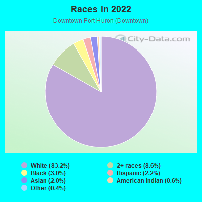
- 5,44483.2%White
- 5628.6%Two or more races
- 1963.0%Black
- 1432.2%Hispanic or Latino
- 1342.0%Asian
- 370.6%American Indian
- 250.4%Some other race

Distribution of median household income
![Distribution of median household income]()
- 538Less than $10,000
- 723$10,000 to $19,999
- 469$20,000 to $29,999
- 226$30,000 to $39,999
- 456$40,000 to $49,999
- 200$50,000 to $59,999
- 191$60,000 to $74,999
- 189$75,000 to $99,999
- 126$100,000 to $124,999
- 171$125,000 to $149,999
- 95$150,000 to $199,999
- 191$200,000 or more

Distribution of owner-occupied house/condo value
![Distribution of owner-occupied house/condo value]()
- 822Less than $50,000
- 1,058$50,000 to $99,999
- 302$100,000 to $149,999
- 560$150,000 to $199,999
- 157$200,000 to $249,999
- 183$250,000 to $299,999
- 159$300,000 to $399,999
- 261$400,000 to $499,999
- 79$500,000 to $749,999
- 27$750,000 to $999,999

Distribution of rent paid by renters
![Distribution of rent paid by renters]()
- 247$100 to $199
- 1,110$200 to $299
- 708$300 to $399
- 436$400 to $499
- 307$500 to $599
- 247$600 to $699
- 414$700 to $799
- 173$800 to $899
- 188$900 to $999
- 70$1,000 to $1,249
- 174$1,250 to $1,499

| Males: | 3,180 |
| Females: | 3,253 |
Males:
| This neighborhood: | |
| Whole city: |
| This neighborhood: | |
| Whole city: |
Percentage of family households:
| Downtown Port Huron (Downtown): | 44.0% |
| Port Huron: | 43.4% |
| Here: | 25.5% |
| Port Huron: | 32.9% |
Percentage of married-couple families with children (among all households):
| Downtown Port Huron (Downtown): | 29.0% |
| Port Huron: | 18.6% |
Percentage of single-mother households (among all households):
| Downtown Port Huron (Downtown): | 22.2% |
| Port Huron: | 18.7% |
Percentage of never married males 15 years old and over:
Percentage of never married females 15 years old and over:
| Downtown Port Huron (Downtown): | 21.2% |
| Port Huron: | 20.6% |
Percentage of never married females 15 years old and over:
| Downtown Port Huron (Downtown): | 18.2% |
| city: | 18.1% |
Percentage of people that speak English not well or not at all:
| Downtown Port Huron (Downtown): | 2.1% |
| Port Huron: | 0.3% |
Percentage of people born in this state:
Percentage of people born in another U.S. state:
Percentage of native residents but born outside the U.S.:
Percentage of foreign born residents:
| Here: | 86.9% |
| Port Huron: | 86.8% |
Percentage of people born in another U.S. state:
| Downtown Port Huron (Downtown): | 8.6% |
| Port Huron: | 9.9% |
Percentage of native residents but born outside the U.S.:
| Here: | 0.5% |
| city: | 1.0% |
Percentage of foreign born residents:
| Here: | 4.0% |
| Port Huron: | 2.4% |
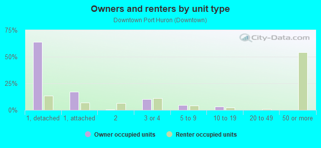
Owner-occupied
Renter-occupied

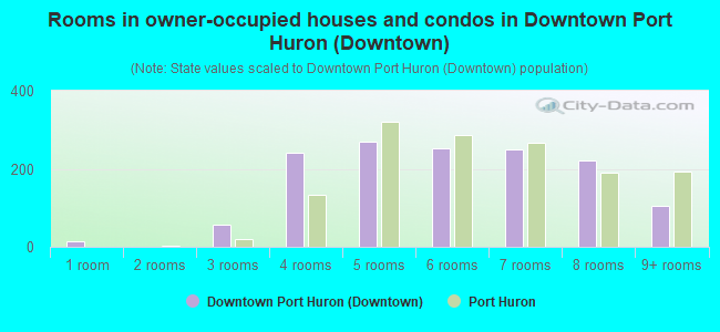
- Rooms in owner-occupied houses and condos in Downtown Port Huron <
> - 131 room
- 02 rooms
- 573 rooms
- 2424 rooms
- 2705 rooms
- 2536 rooms
- 2507 rooms
- 2208 rooms
- 1069+ rooms
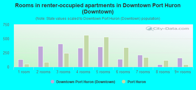
- Rooms in renter-occupied apartments in Downtown Port Huron <
> - 1331 room
- 3692 rooms
- 4073 rooms
- 3364 rooms
- 3575 rooms
- 1386 rooms
- 2117 rooms
- 438 rooms
- 1579+ rooms
Owner-occupied
Renter-occupied
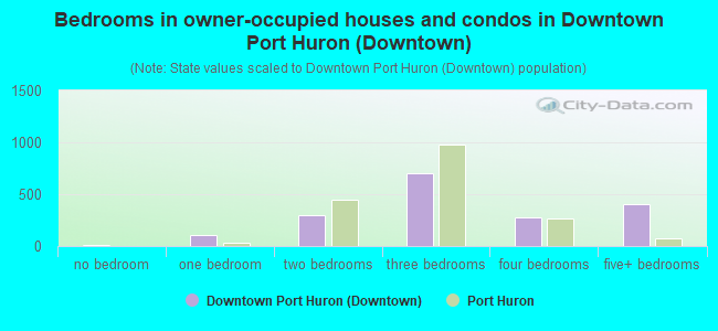
- Bedrooms in owner-occupied houses and condos in Downtown Port Huron <
> - 13no bedroom
- 1101 bedroom
- 2932 bedrooms
- 7033 bedrooms
- 2814 bedrooms
- 4035+ bedrooms
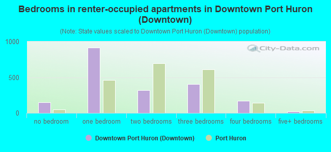
- Bedrooms in renter-occupied apartments in Downtown Port Huron <
> - 152no bedroom
- 9131 bedroom
- 3222 bedrooms
- 4073 bedrooms
- 1684 bedrooms
- 245+ bedrooms
Average number of cars or other vehicles available in houses/condos:
Average number of cars or other vehicles available in apartments:
| This neighborhood: | |
| Port Huron: |
Average number of cars or other vehicles available in apartments:
| Here: | |
| city: |
Percentage of units with a mortgage:
| Downtown Port Huron (Downtown): | 57.4% |
| Port Huron: | 55.9% |
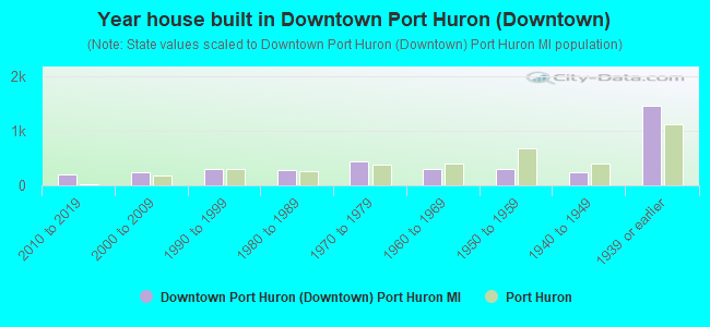
- Year house built in Downtown Port Huron <
> - 02020 or later
- 2022010 to 2019
- 2332000 to 2009
- 2911990 to 1999
- 2871980 to 1989
- 4381970 to 1979
- 3031960 to 1969
- 2961950 to 1959
- 2381940 to 1949
- 1,4481939 or earlier
City-data.com crime index for city in 2020 (higher means more crime):
| City: | 339.7 |
| U.S. average: | 219.5 |
Travel time to work (commute)
![Travel time to work (commute)]()
- 51Less than 5 minutes
- 2515 to 9 minutes
- 30110 to 14 minutes
- 39015 to 19 minutes
- 24720 to 24 minutes
- 20325 to 29 minutes
- 14230 to 34 minutes
- 2435 to 39 minutes
- 3240 to 44 minutes
- 9545 to 59 minutes
- 7960 to 89 minutes
- 4390 or more minutes

Means of transportation to work
![Means of transportation to work]()
- 71.1%1,468Drove a car alone
- 19.0%393Carpooled
- 5.5%114Bus
- 1.0%20Taxi
- 1.9%40Bicycle
- 3.7%76Walked
- 4.2%86Other means
- 3.3%68Worked at home

Time leaving home to go to work
![Time leaving home to go to work]()
- 9712:00 a.m. to 4:59 a.m.
- 765:00 a.m. to 5:29 a.m.
- 1025:30 a.m. to 5:59 a.m.
- 1946:00 a.m. to 6:29 a.m.
- 1386:30 a.m. to 6:59 a.m.
- 517:00 a.m. to 7:29 a.m.
- 977:30 a.m. to 7:59 a.m.
- 2228:00 a.m. to 8:29 a.m.
- 768:30 a.m. to 8:59 a.m.
- 429:00 a.m. to 9:59 a.m.
- 14810:00 a.m. to 10:59 a.m.
- 9011:00 a.m. to 11:59 a.m.
- 44812:00 p.m. to 3:59 p.m.
- 1574:00 p.m. to 11:59 p.m.

Occupations of males:
- Percentage of males in management occupations (except farmers):
Here: 2.5% city: 8.3%
- Percentage of males in business and financial operations occupations:
Here: 4.1% city: 3.7%
- Percentage of males in architecture and engineering occupations:
Here: 4.7% city: 4.8%
- Percentage of males in education, training, and library occupations:
Here: 2.1% city: 2.6%
- Percentage of males in service occupations:
Here: 16.2% city: 14.4%
- Percentage of males in sales and office occupations:
Here: 7.4% city: 13.7%
- Percentage of males in farming, fishing, and forestry occupations:
Here: 3.3% city: 0.4%
- Percentage of males in construction, extraction, and maintenance occupations:
Here: 7.9% city: 7.6%
- Percentage of males in production occupations:
Here: 37.6% city: 20.6%
- Percentage of males in transportation occupations:
Here: 3.3% city: 5.0%
- Percentage of males in material moving occupations:
Here: 3.5% city: 5.2%
Occupations of females:
- Percentage of females in management occupations (except farmers):
Here: 4.5% city: 6.2%
- Percentage of females in business and financial operations occupations:
Here: 1.1% city: 2.9%
- Percentage of females in community and social services occupations:
Here: 1.2% city: 2.2%
- Percentage of females in legal occupations:
Here: 12.1% city: 1.0%
- Percentage of females in education, training, and library occupations:
Here: 2.5% city: 5.4%
- Percentage of females in arts, design, entertainment, sports, and media occupations:
Here: 2.9% city: 2.1%
- Percentage of females in healthcare practitioners and technical occupations:
Here: 5.6% city: 5.9%
- Percentage of females in service occupations:
Here: 33.1% city: 30.9%
- Percentage of females in sales and office occupations:
Here: 11.7% city: 28.3%
- Percentage of females in construction, extraction, and maintenance occupations:
Here: 2.8% city: 0.9%
- Percentage of females in production occupations:
Here: 10.9% city: 7.5%
- Percentage of females in transportation occupations:
Here: 1.9% city: 2.1%
- Percentage of females in material moving occupations:
Here: 9.6% city: 3.3%
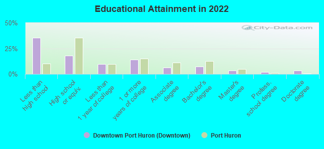
Education in this neighborhood (subdivision or community):
- Percentage of people 3 years and older in K-12 schools:
Downtown Port Huron (Downtown): 30.8% Port Huron: 17.0%
- Percentage of people 3 years and older in undergraduate colleges:
Downtown Port Huron (Downtown): 2.6% Port Huron: 3.6%
- Percentage of people 3 years and older in grad. or professional schools:
Downtown Port Huron (Downtown): 2.0% Port Huron: 0.5%
- Percentage of students K-12 enrolled in private schools:
Downtown Port Huron (Downtown): 19.8% Port Huron: 6.3%
Percentage of population below poverty level:
| Downtown Port Huron (Downtown): | 37.6% |
| Port Huron: | 22.2% |
Percentage of married-couple families with both working:
| Downtown Port Huron (Downtown): | 101.6% |
| Port Huron: | 72.0% |
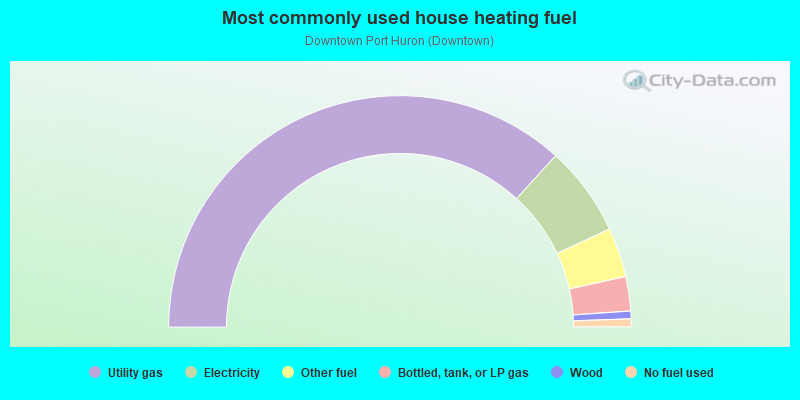
- 73.5%Utility gas
- 12.6%Electricity
- 6.9%Other fuel
- 4.8%Bottled, tank, or LP gas
- 1.1%Wood
- 1.1%No fuel used
Limited-access highways (interstate or state) in this neighborhood:
Pine Grove Ave (I- 69 Bus, State Hwy 25, I- 94 Bus)
Length: 2.11 miles
Directions: E-W, N-S, SE-NW, SW-NE
Address range: 100 to 1799
Directions: E-W, N-S, SE-NW, SW-NE
Address range: 100 to 1799
Highways in this neighborhood:
Military St (State Hwy 25, I- 94 Bus)
Length: 0.19 miles
Direction: N-S
Address range: 1600 to 1899
Direction: N-S
Address range: 1600 to 1899
Roads and streets:
Water St
Length: 1.19 miles
Directions: E-W, SE-NW
Address range: 100 to 1499
Directions: E-W, SE-NW
Address range: 100 to 1499
Stone St
Length: 0.93 miles
Direction: N-S
Address range: 700 to 1806
Direction: N-S
Address range: 700 to 1806
Fort St
Length: 0.90 miles
Directions: N-S, SE-NW, SW-NE
Address range: 100 to 899
Directions: N-S, SE-NW, SW-NE
Address range: 100 to 899
Stanton St
Length: 0.86 miles
Direction: E-W
Address range: 300 to 1499
Direction: E-W
Address range: 300 to 1499
Glenwood Ave
Length: 0.83 miles
Directions: E-W, SW-NE
Address range: 200 to 1399
Directions: E-W, SW-NE
Address range: 200 to 1399
Poplar St
Length: 0.82 miles
Directions: N-S, SE-NW
Address range: 700 to 1799
Directions: N-S, SE-NW
Address range: 700 to 1799
Merchant St
Length: 0.81 miles
Directions: N-S, SE-NW, SW-NE
Address range: 1 to 1099
Directions: N-S, SE-NW, SW-NE
Address range: 1 to 1099
Mc Morran Blvd
Length: 0.80 miles
Directions: E-W, SE-NW, SW-NE
Address range: 100 to 899
Directions: E-W, SE-NW, SW-NE
Address range: 100 to 899
Rawlins St
Length: 0.80 miles
Direction: E-W
Address range: 300 to 1499
Direction: E-W
Address range: 300 to 1499
Lincoln Ave
Length: 0.80 miles
Direction: E-W
Address range: 500 to 1599
Direction: E-W
Address range: 500 to 1599
Kearney St
Length: 0.78 miles
Direction: E-W
Address range: 800 to 1799
Direction: E-W
Address range: 800 to 1799
10th Ave
Length: 0.78 miles
Direction: N-S
Address range: 800 to 1799
Direction: N-S
Address range: 800 to 1799
Whipple St
Length: 0.77 miles
Directions: E-W, N-S, SE-NW
Address range: 800 to 1799
Directions: E-W, N-S, SE-NW
Address range: 800 to 1799
Elk St
Length: 0.76 miles
Directions: N-S, SW-NE
Address range: 800 to 1799
Directions: N-S, SW-NE
Address range: 800 to 1799
Erie St
Length: 0.75 miles
Directions: N-S, SW-NE
Address range: 200 to 1599
Directions: N-S, SW-NE
Address range: 200 to 1599
Mc Pherson St
Length: 0.72 miles
Direction: E-W
Address range: 1100 to 1799
Direction: E-W
Address range: 1100 to 1799
River St
Length: 0.70 miles
Direction: SE-NW
Address range: 500 to 1199
Direction: SE-NW
Address range: 500 to 1199
Thomas St
Length: 0.69 miles
Direction: E-W
Address range: 900 to 1799
Direction: E-W
Address range: 900 to 1799
Sedgwick St
Length: 0.68 miles
Direction: E-W
Address range: 800 to 1599
Direction: E-W
Address range: 800 to 1599
11th Ave
Length: 0.60 miles
Direction: N-S
Address range: 1000 to 1799
Direction: N-S
Address range: 1000 to 1799
Michigan St
Length: 0.59 miles
Directions: N-S, SW-NE
Address range: 100 to 1028
Directions: N-S, SW-NE
Address range: 100 to 1028
Washington Ave
Length: 0.55 miles
Direction: E-W
Address range: 1000 to 1799
Direction: E-W
Address range: 1000 to 1799
Grand River Ave
Length: 0.53 miles
Direction: E-W
Address range: 100 to 699
Direction: E-W
Address range: 100 to 699
Lapeer Ave
Length: 0.51 miles
Direction: E-W
Address range: 700 to 1099
Direction: E-W
Address range: 700 to 1099
Willow St
Length: 0.51 miles
Direction: N-S
Address range: 800 to 1699
Direction: N-S
Address range: 800 to 1699
Pine St
Length: 0.50 miles
Directions: E-W, SW-NE
Address range: 200 to 799
Directions: E-W, SW-NE
Address range: 200 to 799
12th Ave
Length: 0.50 miles
Directions: N-S, SE-NW
Address range: 1100 to 1799
Directions: N-S, SE-NW
Address range: 1100 to 1799
Bard St
Length: 0.49 miles
Direction: E-W
Address range: 200 to 799
Direction: E-W
Address range: 200 to 799
4th St
Length: 0.49 miles
Direction: N-S
Address range: 700 to 1599
Direction: N-S
Address range: 700 to 1599
Quay St
Length: 0.48 miles
Directions: E-W, SE-NW
Address range: 200 to 581
Directions: E-W, SE-NW
Address range: 200 to 581
Wall St
Length: 0.47 miles
Direction: E-W
Address range: 300 to 799
Direction: E-W
Address range: 300 to 799
Court St
Length: 0.47 miles
Direction: E-W
Address range: 200 to 799
Direction: E-W
Address range: 200 to 799
Richardson St
Length: 0.44 miles
Direction: E-W
Address range: 1100 to 1599
Direction: E-W
Address range: 1100 to 1599
Superior St
Length: 0.41 miles
Directions: N-S, SE-NW
Address range: 500 to 1199
Directions: N-S, SE-NW
Address range: 500 to 1199
Thomas Edison Pkwy
Length: 0.41 miles
Directions: N-S, SE-NW
Address range: 500 to 1455
Directions: N-S, SE-NW
Address range: 500 to 1455
10th St
Length: 0.40 miles
Direction: N-S
Address range: 100 to 699
Direction: N-S
Address range: 100 to 699
Edison Shores Pl
Length: 0.39 miles
Directions: N-S, SE-NW, SW-NE
Address range: 1500 to 1899
Directions: N-S, SE-NW, SW-NE
Address range: 1500 to 1899
Beers St
Length: 0.37 miles
Direction: E-W
Address range: 200 to 699
Direction: E-W
Address range: 200 to 699
Michigan
Length: 0.35 miles
Directions: N-S, SE-NW
Address range: 1100 to 1399
Directions: N-S, SE-NW
Address range: 1100 to 1399
Ontario St
Length: 0.34 miles
Direction: N-S
Address range: 600 to 1099
Direction: N-S
Address range: 600 to 1099
Mc Brady
Length: 0.32 miles
Direction: E-W
Address range: 1600 to 1724
Direction: E-W
Address range: 1600 to 1724
11th St
Length: 0.31 miles
Directions: N-S, SE-NW
Address range: 300 to 699
Directions: N-S, SE-NW
Address range: 300 to 699
St Clair St
Length: 0.30 miles
Direction: N-S
Address range: 800 to 1199
Direction: N-S
Address range: 800 to 1199
8th St
Length: 0.30 miles
Direction: N-S
Address range: 800 to 1199
Direction: N-S
Address range: 800 to 1199
7th St
Length: 0.28 miles
Direction: N-S
Address range: 800 to 1199
Direction: N-S
Address range: 800 to 1199
Edison Shores Ln
Length: 0.26 miles
Directions: N-S, SW-NE
Address range: 1500 to 1799
Directions: N-S, SW-NE
Address range: 1500 to 1799
Arch St
Length: 0.26 miles
Directions: E-W, N-S, SE-NW, SW-NE
Address range: 1300 to 1399
Directions: E-W, N-S, SE-NW, SW-NE
Address range: 1300 to 1399
6th St
Length: 0.26 miles
Direction: N-S
Address range: 900 to 1199
Direction: N-S
Address range: 900 to 1199
Dockside Dr
Length: 0.25 miles
Directions: E-W, N-S, SE-NW, SW-NE
Address range: 800 to 999
Directions: E-W, N-S, SE-NW, SW-NE
Address range: 800 to 999
River Centre Dr
Length: 0.25 miles
Directions: E-W, N-S, SE-NW, SW-NE
Directions: E-W, N-S, SE-NW, SW-NE
Huron Ave
Length: 0.22 miles
Direction: N-S
Address range: 800 to 1099
Direction: N-S
Address range: 800 to 1099
Prospect
Length: 0.16 miles
Directions: E-W, SW-NE
Address range: 800 to 999
Directions: E-W, SW-NE
Address range: 800 to 999
3rd St
Length: 0.16 miles
Direction: N-S
Address range: 900 to 1199
Direction: N-S
Address range: 900 to 1199
Pointe Dr
Length: 0.15 miles
Directions: E-W, N-S, SE-NW, SW-NE
Address range: 700 to 899
Directions: E-W, N-S, SE-NW, SW-NE
Address range: 700 to 899
Pine Grove Park Dr
Length: 0.14 miles
Directions: E-W, N-S, SW-NE
Address range: 500 to 699
Directions: E-W, N-S, SW-NE
Address range: 500 to 699
Andrew Murphy Ave
Length: 0.14 miles
Direction: E-W
Address range: 400 to 599
Direction: E-W
Address range: 400 to 599
Miller St
Length: 0.13 miles
Direction: E-W
Address range: 1000 to 1099
Direction: E-W
Address range: 1000 to 1099
Wells St
Length: 0.13 miles
Direction: E-W
Address range: 1000 to 1099
Direction: E-W
Address range: 1000 to 1099
Pearl St
Length: 0.13 miles
Direction: E-W
Address range: 1000 to 1099
Direction: E-W
Address range: 1000 to 1099
Howard St
Length: 0.13 miles
Direction: E-W
Address range: 700 to 799
Direction: E-W
Address range: 700 to 799
Varney St
Length: 0.13 miles
Direction: E-W
Address range: 1000 to 1099
Direction: E-W
Address range: 1000 to 1099
Edison Shores Ct
Length: 0.12 miles
Directions: E-W, N-S, SE-NW, SW-NE
Address range: 900 to 1099
Directions: E-W, N-S, SE-NW, SW-NE
Address range: 900 to 1099
Clyde St
Length: 0.10 miles
Directions: E-W, N-S, SE-NW
Directions: E-W, N-S, SE-NW
White St
Length: 0.09 miles
Direction: E-W
Address range: 400 to 499
Direction: E-W
Address range: 400 to 499
Chestnut St
Length: 0.09 miles
Direction: E-W
Address range: 400 to 499
Direction: E-W
Address range: 400 to 499
Pleasant
Length: 0.09 miles
Direction: SE-NW
Address range: 1400 to 1435
Direction: SE-NW
Address range: 1400 to 1435
Superior Mall
Length: 0.08 miles
Direction: N-S
Address range: 300 to 399
Direction: N-S
Address range: 300 to 399
Cross Pointe Dr
Length: 0.07 miles
Directions: N-S, SW-NE
Address range: 700 to 799
Directions: N-S, SW-NE
Address range: 700 to 799
Edison Shores St
Length: 0.06 miles
Direction: E-W
Direction: E-W
13th St
Length: 0.06 miles
Directions: N-S, SW-NE
Address range: 1 to 80
Directions: N-S, SW-NE
Address range: 1 to 80
Gillett St
Length: 0.05 miles
Direction: E-W
Address range: 800 to 812
Direction: E-W
Address range: 800 to 812
N Pointe Dr
Length: 0.05 miles
Direction: SE-NW
Address range: 800 to 899
Direction: SE-NW
Address range: 800 to 899
Ward St
Length: 0.05 miles
Directions: E-W, SW-NE
Address range: 1000 to 1099
Directions: E-W, SW-NE
Address range: 1000 to 1099
Dockside Ct
Length: 0.05 miles
Direction: SE-NW
Address range: 900 to 999
Direction: SE-NW
Address range: 900 to 999
W Pointe Dr
Length: 0.04 miles
Direction: SE-NW
Address range: 800 to 899
Direction: SE-NW
Address range: 800 to 899
E Pointe Dr
Length: 0.04 miles
Direction: SE-NW
Address range: 801 to 827
Direction: SE-NW
Address range: 801 to 827
Sherman St
Length: 0.03 miles
Direction: SW-NE
Direction: SW-NE
Railroad features:
Grand Trunk Western RR
Length: 1.84 miles
Directions: E-W, N-S, SE-NW, SW-NE
Directions: E-W, N-S, SE-NW, SW-NE