North End neighborhood in Port Huron, Michigan (MI), 48059, 48060 detailed profile
Settings
X


Business Search - 14 Million verified businesses
Area: 3.514 square miles
Population: 7,934
Population density:
| North End: | 2,258 people per square mile |
| Port Huron: | 3,574 people per square mile |

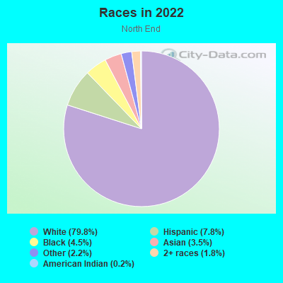
- 6,74979.8%White
- 6637.8%Hispanic or Latino
- 3784.5%Black
- 2953.5%Asian
- 1882.2%Some other race
- 1561.8%Two or more races
- 200.2%American Indian
- 60.07%Native Hawaiian and Other
Pacific Islander
Distribution of median household income
![Distribution of median household income]()
- 181Less than $10,000
- 276$10,000 to $19,999
- 330$20,000 to $29,999
- 449$30,000 to $39,999
- 373$40,000 to $49,999
- 221$50,000 to $59,999
- 351$60,000 to $74,999
- 504$75,000 to $99,999
- 146$100,000 to $124,999
- 249$125,000 to $149,999
- 306$150,000 to $199,999
- 326$200,000 or more

Distribution of owner-occupied house/condo value
![Distribution of owner-occupied house/condo value]()
- 1,485Less than $50,000
- 1,870$50,000 to $99,999
- 607$100,000 to $149,999
- 692$150,000 to $199,999
- 386$200,000 to $249,999
- 270$250,000 to $299,999
- 362$300,000 to $399,999
- 166$400,000 to $499,999
- 125$500,000 to $749,999
- 211$750,000 to $999,999
- 525$1,000,000 or more

Distribution of rent paid by renters
![Distribution of rent paid by renters]()
- 13Less than $100
- 456$100 to $199
- 77$200 to $299
- 197$300 to $399
- 455$400 to $499
- 171$500 to $599
- 336$600 to $699
- 583$700 to $799
- 142$800 to $899
- 157$900 to $999
- 152$1,000 to $1,249
- 97$1,250 to $1,499
- 12$1,500 to $1,999
- 143$2,000 or more

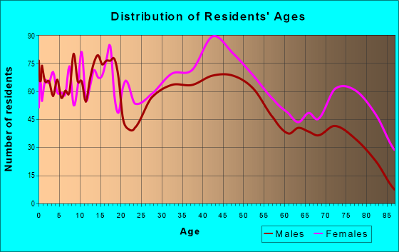
| Males: | 3,925 |
| Females: | 4,008 |
Males:
| This neighborhood: | 42.2 years |
| Whole city: | 34.8 years |
| This neighborhood: | 45.1 years |
| Whole city: | 41.2 years |
Average household size:
| North End: | 2.3 people |
| Port Huron: | 2.3 people |
Percentage of family households:
| North End: | 44.0% |
| Port Huron: | 43.4% |
| Here: | 46.0% |
| Port Huron: | 32.9% |
Percentage of married-couple families with children (among all households):
| North End: | 28.8% |
| Port Huron: | 18.6% |
Percentage of single-mother households (among all households):
| North End: | 6.7% |
| Port Huron: | 18.7% |
Percentage of never married males 15 years old and over:
Percentage of never married females 15 years old and over:
| North End: | 17.3% |
| Port Huron: | 20.6% |
Percentage of never married females 15 years old and over:
| North End: | 15.4% |
| city: | 18.1% |
Percentage of people that speak English not well or not at all:
| North End: | 0.2% |
| Port Huron: | 0.3% |
Percentage of people born in this state:
Percentage of people born in another U.S. state:
Percentage of native residents but born outside the U.S.:
Percentage of foreign born residents:
| Here: | 86.3% |
| Port Huron: | 86.8% |
Percentage of people born in another U.S. state:
| North End: | 9.1% |
| Port Huron: | 9.9% |
Percentage of native residents but born outside the U.S.:
| Here: | 2.8% |
| city: | 1.0% |
Percentage of foreign born residents:
| Here: | 2.8% |
| Port Huron: | 2.4% |
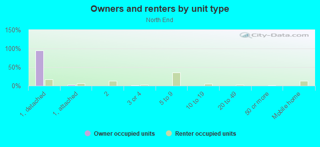
Owner-occupied
Renter-occupied

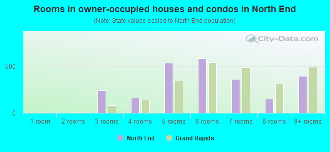
- Rooms in owner-occupied houses and condos in North End
- 61 room
- 1322 rooms
- 4153 rooms
- 2584 rooms
- 4375 rooms
- 5406 rooms
- 4847 rooms
- 3928 rooms
- 4479+ rooms
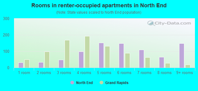
- Rooms in renter-occupied apartments in North End
- 1321 room
- 2032 rooms
- 883 rooms
- 3084 rooms
- 2665 rooms
- 3456 rooms
- 2867 rooms
- 1408 rooms
- 729+ rooms
Owner-occupied
Renter-occupied
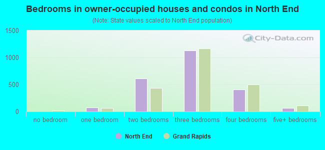
- Bedrooms in owner-occupied houses and condos in North End
- 79no bedroom
- 1291 bedroom
- 4482 bedrooms
- 1,5013 bedrooms
- 4814 bedrooms
- 2345+ bedrooms
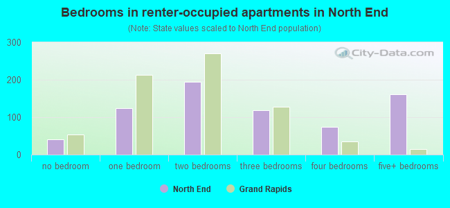
- Bedrooms in renter-occupied apartments in North End
- 132no bedroom
- 1441 bedroom
- 5472 bedrooms
- 2983 bedrooms
- 1874 bedrooms
- 1575+ bedrooms
Average number of cars or other vehicles available in houses/condos:
Average number of cars or other vehicles available in apartments:
| This neighborhood: | 1.8 |
| Port Huron: | 1.8 |
Average number of cars or other vehicles available in apartments:
| Here: | |
| city: |
Percentage of units with a mortgage:
| North End: | 57.9% |
| Port Huron: | 55.9% |
Average estimated value of detached houses in 2022 (82.2% of all units):
| North End: | $224,107 |
| Port Huron: | $157,151 |
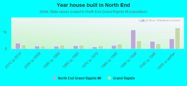
- Year house built in North End
- 502020 or later
- 1582010 to 2019
- 2632000 to 2009
- 2771990 to 1999
- 2861980 to 1989
- 4621970 to 1979
- 7121960 to 1969
- 8091950 to 1959
- 4261940 to 1949
- 7231939 or earlier
City-data.com crime index for city in 2020 (higher means more crime):
| City: | 339.7 |
| U.S. average: | 219.5 |
Travel time to work (commute)
![Travel time to work (commute)]()
- 314Less than 5 minutes
- 6475 to 9 minutes
- 90810 to 14 minutes
- 62215 to 19 minutes
- 27020 to 24 minutes
- 7125 to 29 minutes
- 32930 to 34 minutes
- 9735 to 39 minutes
- 13340 to 44 minutes
- 28245 to 59 minutes
- 29960 to 89 minutes
- 13690 or more minutes

Means of transportation to work
![Means of transportation to work]()
- 78.5%2,911Drove a car alone
- 12.3%455Carpooled
- 2.6%96Bus
- 2.0%75Ferryboat
- 0.1%4Taxi
- 3.2%119Bicycle
- 1.5%55Walked
- 3.6%133Other means
- 6.7%250Worked at home

Time leaving home to go to work
![Time leaving home to go to work]()
- 21912:00 a.m. to 4:59 a.m.
- 1415:00 a.m. to 5:29 a.m.
- 1845:30 a.m. to 5:59 a.m.
- 2356:00 a.m. to 6:29 a.m.
- 2866:30 a.m. to 6:59 a.m.
- 4327:00 a.m. to 7:29 a.m.
- 6927:30 a.m. to 7:59 a.m.
- 4808:00 a.m. to 8:29 a.m.
- 2998:30 a.m. to 8:59 a.m.
- 3139:00 a.m. to 9:59 a.m.
- 15410:00 a.m. to 10:59 a.m.
- 5211:00 a.m. to 11:59 a.m.
- 33712:00 p.m. to 3:59 p.m.
- 1404:00 p.m. to 11:59 p.m.

Occupations of males:
- Percentage of males in management occupations (except farmers):
Here: 16.8% city: 8.3%
- Percentage of males in business and financial operations occupations:
Here: 9.3% city: 3.7%
- Percentage of males in computer and mathematical occupations:
Here: 2.6% city: 1.4%
- Percentage of males in architecture and engineering occupations:
Here: 4.3% city: 4.8%
- Percentage of males in community and social services occupations:
Here: 5.7% city: 2.3%
- Percentage of males in legal occupations:
Here: 1.4% city: 0.2%
- Percentage of males in education, training, and library occupations:
Here: 1.8% city: 2.6%
- Percentage of males in arts, design, entertainment, sports, and media occupations:
Here: 1.2% city: 0.7%
- Percentage of males in healthcare practitioners and technical occupations:
Here: 5.6% city: 2.1%
- Percentage of males in service occupations:
Here: 11.7% city: 14.4%
- Percentage of males in sales and office occupations:
Here: 10.7% city: 13.7%
- Percentage of males in construction, extraction, and maintenance occupations:
Here: 4.0% city: 7.6%
- Percentage of males in production occupations:
Here: 12.9% city: 20.6%
- Percentage of males in transportation occupations:
Here: 2.0% city: 5.0%
- Percentage of males in material moving occupations:
Here: 5.0% city: 5.2%
Occupations of females:
- Percentage of females in management occupations (except farmers):
Here: 4.7% city: 6.2%
- Percentage of females in business and financial operations occupations:
Here: 8.1% city: 2.9%
- Percentage of females in community and social services occupations:
Here: 1.4% city: 2.2%
- Percentage of females in education, training, and library occupations:
Here: 11.4% city: 5.4%
- Percentage of females in arts, design, entertainment, sports, and media occupations:
Here: 3.1% city: 2.1%
- Percentage of females in healthcare practitioners and technical occupations:
Here: 9.2% city: 5.9%
- Percentage of females in service occupations:
Here: 22.9% city: 30.9%
- Percentage of females in sales and office occupations:
Here: 29.1% city: 28.3%
- Percentage of females in production occupations:
Here: 5.2% city: 7.5%
- Percentage of females in transportation occupations:
Here: 1.1% city: 2.1%
- Percentage of females in material moving occupations:
Here: 2.7% city: 3.3%
Percentage of people 16-64 in Armed Forces:
| North End: | 0.0% |
| Port Huron: | 0.0% |
Education in this neighborhood (subdivision or community):
- Percentage of people 3 years and older in K-12 schools:
North End: 17.3% Port Huron: 17.0%
- Percentage of people 3 years and older in undergraduate colleges:
North End: 6.9% Port Huron: 3.6%
- Percentage of people 3 years and older in grad. or professional schools:
North End: 3.0% Port Huron: 0.5%
- Percentage of students K-12 enrolled in private schools:
North End: 39.7% Port Huron: 6.3%
Percentage of population below poverty level:
| North End: | 9.3% |
| Port Huron: | 22.2% |
Median year owner moved in (as recorded in 2022):
| North End: | 2008 |
| Port Huron: | 2007 |
Percentage of married-couple families with both working:
| North End: | 113.8% |
| Port Huron: | 72.0% |
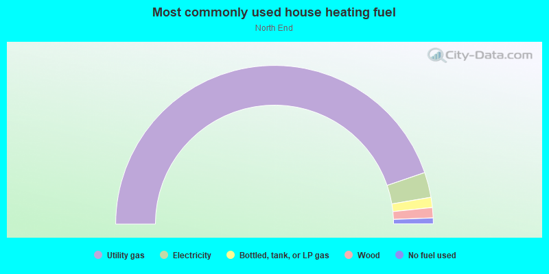
- 72.3%Utility gas
- 7.7%Electricity
- 6.3%No fuel used
- 5.9%Bottled, tank, or LP gas
- 3.8%Wood
- 2.5%Other fuel
- 1.4%Fuel oil, kerosene, etc.
Highways in this neighborhood:
Pine Grove Ave (State Hwy 136)
Length: 2.52 miles
Directions: E-W, N-S, SE-NW
Address range: 2400 to 3833
Directions: E-W, N-S, SE-NW
Address range: 2400 to 3833
State Hwy 25 (24th Ave)
Length: 0.37 miles
Directions: N-S, SW-NE
Address range: 3800 to 3999
Directions: N-S, SW-NE
Address range: 3800 to 3999
State Hwy 25
Length: 0.08 miles
Directions: N-S, SE-NW
Directions: N-S, SE-NW
I- 94 Bus (Pine Grove Ave, I- 69 Bus, State Hwy 25)
Length: 0.03 miles
Direction: SE-NW
Address range: 2300 to 2399
Direction: SE-NW
Address range: 2300 to 2399
Roads and streets:
I- 94
Length: 4.43 miles
Directions: E-W, N-S, SW-NE
Directions: E-W, N-S, SW-NE
Gratiot Ave
Length: 3.25 miles
Directions: E-W, N-S, SE-NW, SW-NE
Address range: 2300 to 4499
Directions: E-W, N-S, SE-NW, SW-NE
Address range: 2300 to 4499
Hancock St
Length: 1.99 miles
Directions: E-W, SW-NE
Address range: 300 to 2799
Directions: E-W, SW-NE
Address range: 300 to 2799
Garfield St
Length: 1.93 miles
Direction: E-W
Address range: 300 to 2705
Direction: E-W
Address range: 300 to 2705
Elmwood St
Length: 1.86 miles
Directions: E-W, SE-NW, SW-NE
Address range: 400 to 2999
Directions: E-W, SE-NW, SW-NE
Address range: 400 to 2999
Kraft Rd
Length: 1.80 miles
Direction: E-W
Address range: 1100 to 3173
Direction: E-W
Address range: 1100 to 3173
Riverside Dr
Length: 1.73 miles
Directions: E-W, N-S, SE-NW, SW-NE
Address range: 2000 to 3499
Directions: E-W, N-S, SE-NW, SW-NE
Address range: 2000 to 3499
Sanborn St
Length: 1.59 miles
Directions: E-W, SW-NE
Address range: 500 to 2413
Directions: E-W, SW-NE
Address range: 500 to 2413
Holland Ave
Length: 1.57 miles
Direction: E-W
Address range: 401 to 2099
Direction: E-W
Address range: 401 to 2099
Church St
Length: 1.53 miles
Directions: E-W, SW-NE
Address range: 400 to 2599
Directions: E-W, SW-NE
Address range: 400 to 2599
Riverview St
Length: 1.39 miles
Directions: E-W, N-S
Address range: 100 to 2399
Directions: E-W, N-S
Address range: 100 to 2399
10th Ave
Length: 1.33 miles
Direction: N-S
Address range: 2400 to 3599
Direction: N-S
Address range: 2400 to 3599
Armour St
Length: 1.33 miles
Directions: N-S, SE-NW, SW-NE
Address range: 2300 to 3599
Directions: N-S, SE-NW, SW-NE
Address range: 2300 to 3599
Stone St
Length: 1.30 miles
Direction: N-S
Address range: 2300 to 3599
Direction: N-S
Address range: 2300 to 3599
Fairway Dr
Length: 1.13 miles
Directions: N-S, SE-NW
Address range: 4000 to 4499
Directions: N-S, SE-NW
Address range: 4000 to 4499
Conger St
Length: 1.02 miles
Directions: E-W, N-S, SE-NW, SW-NE
Address range: 2800 to 3699
Directions: E-W, N-S, SE-NW, SW-NE
Address range: 2800 to 3699
Walnut St
Length: 0.98 miles
Direction: N-S
Address range: 2300 to 3599
Direction: N-S
Address range: 2300 to 3599
12th Ave
Length: 0.83 miles
Directions: N-S, SE-NW
Address range: 2300 to 3299
Directions: N-S, SE-NW
Address range: 2300 to 3299
Wright St
Length: 0.79 miles
Directions: N-S, SW-NE
Address range: 2401 to 3179
Directions: N-S, SW-NE
Address range: 2401 to 3179
Ballentine St
Length: 0.74 miles
Direction: E-W
Address range: 200 to 1599
Direction: E-W
Address range: 200 to 1599
Omar St
Length: 0.71 miles
Directions: N-S, SE-NW
Address range: 2600 to 3299
Directions: N-S, SE-NW
Address range: 2600 to 3299
Forest St
Length: 0.68 miles
Direction: N-S
Address range: 2300 to 3199
Direction: N-S
Address range: 2300 to 3199
17th Ave
Length: 0.68 miles
Directions: E-W, N-S, SE-NW
Address range: 2300 to 2999
Directions: E-W, N-S, SE-NW
Address range: 2300 to 2999
Edison Blvd
Length: 0.66 miles
Directions: E-W, SW-NE
Address range: 300 to 1215
Directions: E-W, SW-NE
Address range: 300 to 1215
18th Ave
Length: 0.64 miles
Direction: N-S
Address range: 2300 to 2999
Direction: N-S
Address range: 2300 to 2999
Cherry St
Length: 0.64 miles
Direction: N-S
Address range: 2300 to 3515
Direction: N-S
Address range: 2300 to 3515
Maple St
Length: 0.63 miles
Directions: N-S, SE-NW
Address range: 2300 to 3453
Directions: N-S, SE-NW
Address range: 2300 to 3453
Lakeview Ave
Length: 0.60 miles
Directions: E-W, N-S, SE-NW, SW-NE
Address range: 200 to 899
Directions: E-W, N-S, SE-NW, SW-NE
Address range: 200 to 899
Brandywine Ln
Length: 0.59 miles
Directions: E-W, SW-NE
Address range: 2000 to 2517
Directions: E-W, SW-NE
Address range: 2000 to 2517
16th Ave
Length: 0.58 miles
Directions: N-S, SE-NW
Address range: 2401 to 2951
Directions: N-S, SE-NW
Address range: 2401 to 2951
Palmer Ct
Length: 0.58 miles
Directions: E-W, N-S, SE-NW
Address range: 1100 to 2960
Directions: E-W, N-S, SE-NW
Address range: 1100 to 2960
Woodstock Dr
Length: 0.58 miles
Directions: E-W, N-S, SE-NW, SW-NE
Address range: 2200 to 2999
Directions: E-W, N-S, SE-NW, SW-NE
Address range: 2200 to 2999
Lasalle Blvd
Length: 0.57 miles
Direction: E-W
Address range: 300 to 1038
Direction: E-W
Address range: 300 to 1038
Access Rd
Length: 0.55 miles
Direction: SE-NW
Direction: SE-NW
Florida St
Length: 0.53 miles
Directions: E-W, SW-NE
Address range: 700 to 1312
Directions: E-W, SW-NE
Address range: 700 to 1312
Monticello Dr
Length: 0.51 miles
Directions: N-S, SW-NE
Address range: 2800 to 3246
Directions: N-S, SW-NE
Address range: 2800 to 3246
19th Ave
Length: 0.51 miles
Direction: N-S
Address range: 2400 to 2999
Direction: N-S
Address range: 2400 to 2999
15th Ave
Length: 0.48 miles
Directions: N-S, SE-NW
Address range: 2401 to 2950
Directions: N-S, SE-NW
Address range: 2401 to 2950
Oak Hills Cir
Length: 0.47 miles
Directions: E-W, N-S, SE-NW, SW-NE
Address range: 3800 to 3999
Directions: E-W, N-S, SE-NW, SW-NE
Address range: 3800 to 3999
Jack Pine Ln
Length: 0.45 miles
Directions: E-W, N-S, SE-NW
Address range: 2001 to 3998
Directions: E-W, N-S, SE-NW
Address range: 2001 to 3998
State St
Length: 0.41 miles
Direction: E-W
Address range: 664 to 1099
Direction: E-W
Address range: 664 to 1099
Aspen
Length: 0.39 miles
Directions: N-S, SE-NW
Address range: 3800 to 3999
Directions: N-S, SE-NW
Address range: 3800 to 3999
W Village Ln
Length: 0.37 miles
Directions: E-W, N-S, SW-NE
Address range: 2800 to 3199
Directions: E-W, N-S, SW-NE
Address range: 2800 to 3199
Butternut Ct
Length: 0.37 miles
Directions: E-W, N-S, SE-NW, SW-NE
Address range: 2700 to 3999
Directions: E-W, N-S, SE-NW, SW-NE
Address range: 2700 to 3999
Robinson St
Length: 0.36 miles
Direction: E-W
Address range: 901 to 1599
Direction: E-W
Address range: 901 to 1599
20th Ave
Length: 0.36 miles
Direction: N-S
Address range: 2400 to 2999
Direction: N-S
Address range: 2400 to 2999
Jones Pl
Length: 0.36 miles
Direction: E-W
Address range: 1400 to 1699
Direction: E-W
Address range: 1400 to 1699
Tamarack Dr
Length: 0.33 miles
Directions: E-W, N-S, SW-NE
Address range: 3800 to 3999
Directions: E-W, N-S, SW-NE
Address range: 3800 to 3999
Hollis St
Length: 0.31 miles
Direction: E-W
Address range: 700 to 1099
Direction: E-W
Address range: 700 to 1099
Elk St
Length: 0.29 miles
Direction: N-S
Address range: 3112 to 3433
Direction: N-S
Address range: 3112 to 3433
Shenandoah Ave
Length: 0.28 miles
Direction: N-S
Address range: 3300 to 3599
Direction: N-S
Address range: 3300 to 3599
Riverwood Dr
Length: 0.27 miles
Directions: N-S, SE-NW, SW-NE
Address range: 2300 to 2606
Directions: N-S, SE-NW, SW-NE
Address range: 2300 to 2606
Bonhomme Ct
Length: 0.27 miles
Directions: E-W, N-S, SE-NW, SW-NE
Address range: 800 to 999
Directions: E-W, N-S, SE-NW, SW-NE
Address range: 800 to 999
Ramblewood Dr
Length: 0.27 miles
Directions: E-W, N-S, SE-NW, SW-NE
Address range: 3600 to 3899
Directions: E-W, N-S, SE-NW, SW-NE
Address range: 3600 to 3899
Mount Vernon Rd
Length: 0.26 miles
Direction: SE-NW
Address range: 3019 to 3261
Direction: SE-NW
Address range: 3019 to 3261
Poplar St
Length: 0.25 miles
Directions: N-S, SE-NW
Address range: 3100 to 3399
Directions: N-S, SE-NW
Address range: 3100 to 3399
Canal Dr
Length: 0.25 miles
Direction: E-W
Address range: 2820 to 2962
Direction: E-W
Address range: 2820 to 2962
Hazelwood Ln
Length: 0.24 miles
Direction: E-W
Address range: 1400 to 1699
Direction: E-W
Address range: 1400 to 1699
Catalpa Ct
Length: 0.24 miles
Directions: E-W, N-S, SE-NW, SW-NE
Address range: 3800 to 3899
Directions: E-W, N-S, SE-NW, SW-NE
Address range: 3800 to 3899
Wilbur St
Length: 0.24 miles
Direction: E-W
Address range: 2100 to 2223
Direction: E-W
Address range: 2100 to 2223
Harker St
Length: 0.24 miles
Directions: E-W, SW-NE
Address range: 1400 to 1599
Directions: E-W, SW-NE
Address range: 1400 to 1599
Hickory Ln
Length: 0.23 miles
Direction: N-S
Address range: 3214 to 3370
Direction: N-S
Address range: 3214 to 3370
Cooper Ave
Length: 0.23 miles
Directions: N-S, SE-NW
Address range: 2800 to 3099
Directions: N-S, SE-NW
Address range: 2800 to 3099
11th Ave
Length: 0.22 miles
Direction: N-S
Address range: 2800 to 3099
Direction: N-S
Address range: 2800 to 3099
Watson St
Length: 0.22 miles
Direction: E-W
Address range: 1131 to 1177
Direction: E-W
Address range: 1131 to 1177
Schumaker St
Length: 0.21 miles
Direction: E-W
Address range: 1400 to 1599
Direction: E-W
Address range: 1400 to 1599
Russell Ave
Length: 0.21 miles
Direction: E-W
Address range: 1100 to 1399
Direction: E-W
Address range: 1100 to 1399
E Village Ln
Length: 0.21 miles
Directions: E-W, SE-NW
Address range: 3001 to 3299
Directions: E-W, SE-NW
Address range: 3001 to 3299
Joann Ct
Length: 0.21 miles
Direction: E-W
Address range: 1100 to 1325
Direction: E-W
Address range: 1100 to 1325
Myrtle St
Length: 0.21 miles
Direction: E-W
Address range: 1100 to 1322
Direction: E-W
Address range: 1100 to 1322
21st Ave
Length: 0.21 miles
Direction: N-S
Address range: 2400 to 2699
Direction: N-S
Address range: 2400 to 2699
Appomattox Dr
Length: 0.21 miles
Direction: N-S
Address range: 3300 to 3499
Direction: N-S
Address range: 3300 to 3499
Mansfield St
Length: 0.20 miles
Directions: E-W, SE-NW, SW-NE
Address range: 1771 to 1899
Directions: E-W, SE-NW, SW-NE
Address range: 1771 to 1899
Woodstock Cir
Length: 0.20 miles
Direction: E-W
Address range: 2828 to 2956
Direction: E-W
Address range: 2828 to 2956
14th Ave
Length: 0.18 miles
Direction: N-S
Address range: 2600 to 2799
Direction: N-S
Address range: 2600 to 2799
Butternut Dr
Length: 0.17 miles
Directions: E-W, SW-NE
Address range: 2700 to 2899
Directions: E-W, SW-NE
Address range: 2700 to 2899
Kennelworth Dr
Length: 0.17 miles
Directions: E-W, SW-NE
Address range: 1800 to 1999
Directions: E-W, SW-NE
Address range: 1800 to 1999
Colonial
Length: 0.17 miles
Direction: E-W
Address range: 2400 to 2599
Direction: E-W
Address range: 2400 to 2599
Briarwood Dr
Length: 0.16 miles
Directions: E-W, N-S, SW-NE
Address range: 1100 to 1399
Directions: E-W, N-S, SW-NE
Address range: 1100 to 1399
Crimson Ct
Length: 0.16 miles
Directions: N-S, SW-NE
Address range: 3500 to 3599
Directions: N-S, SW-NE
Address range: 3500 to 3599
E Woodland Dr
Length: 0.16 miles
Directions: N-S, SE-NW
Address range: 2932 to 3126
Directions: N-S, SE-NW
Address range: 2932 to 3126
Thomas Edison Pkwy
Length: 0.16 miles
Directions: N-S, SW-NE
Address range: 2300 to 2399
Directions: N-S, SW-NE
Address range: 2300 to 2399
Concord Pl
Length: 0.16 miles
Direction: SW-NE
Address range: 2100 to 2299
Direction: SW-NE
Address range: 2100 to 2299
N River Rd
Length: 0.15 miles
Direction: E-W
Address range: 2900 to 2983
Direction: E-W
Address range: 2900 to 2983
Homer Pl
Length: 0.14 miles
Direction: E-W
Address range: 700 to 819
Direction: E-W
Address range: 700 to 819
W Woodland Dr
Length: 0.13 miles
Directions: N-S, SE-NW
Address range: 2935 to 3141
Directions: N-S, SE-NW
Address range: 2935 to 3141
Continental Ct
Length: 0.13 miles
Direction: E-W
Address range: 1500 to 1699
Direction: E-W
Address range: 1500 to 1699
Parkway Dr
Length: 0.13 miles
Directions: N-S, SE-NW
Address range: 3400 to 3599
Directions: N-S, SE-NW
Address range: 3400 to 3599
Williamsburg Dr
Length: 0.13 miles
Direction: N-S
Address range: 3400 to 3599
Direction: N-S
Address range: 3400 to 3599
Riverwood Ct
Length: 0.13 miles
Directions: E-W, SW-NE
Address range: 2800 to 2899
Directions: E-W, SW-NE
Address range: 2800 to 2899
13th Ave
Length: 0.12 miles
Direction: N-S
Address range: 2600 to 2699
Direction: N-S
Address range: 2600 to 2699
22nd Ave
Length: 0.12 miles
Direction: N-S
Address range: 2400 to 2599
Direction: N-S
Address range: 2400 to 2599
Conger Ave
Length: 0.12 miles
Directions: N-S, SW-NE
Directions: N-S, SW-NE
Holland Park Ln
Length: 0.11 miles
Direction: N-S
Address range: 3500 to 3555
Direction: N-S
Address range: 3500 to 3555
Keewahdin Rd
Length: 0.11 miles
Direction: E-W
Address range: 2600 to 2693
Direction: E-W
Address range: 2600 to 2693
S Woodland Dr
Length: 0.11 miles
Directions: E-W, N-S, SE-NW, SW-NE
Address range: 1800 to 1826
Directions: E-W, N-S, SE-NW, SW-NE
Address range: 1800 to 1826
Abernathy Dr
Length: 0.11 miles
Direction: E-W
Address range: 1200 to 1299
Direction: E-W
Address range: 1200 to 1299
Devonshire
Length: 0.10 miles
Direction: E-W
Address range: 1421 to 1454
Direction: E-W
Address range: 1421 to 1454
Coventry Ln
Length: 0.10 miles
Direction: E-W
Address range: 1420 to 1442
Direction: E-W
Address range: 1420 to 1442
Grace Rd
Length: 0.10 miles
Direction: E-W
Address range: 2600 to 2618
Direction: E-W
Address range: 2600 to 2618
Old Squire Ln
Length: 0.10 miles
Directions: E-W, SW-NE
Address range: 1400 to 1449
Directions: E-W, SW-NE
Address range: 1400 to 1449
Macdonald Rd
Length: 0.10 miles
Direction: E-W
Address range: 1200 to 1299
Direction: E-W
Address range: 1200 to 1299
Alden Ct
Length: 0.10 miles
Direction: N-S
Address range: 3001 to 3039
Direction: N-S
Address range: 3001 to 3039
N Woodland Dr
Length: 0.09 miles
Directions: E-W, SW-NE
Address range: 1801 to 1899
Directions: E-W, SW-NE
Address range: 1801 to 1899
Lakeside Park Dr
Length: 0.09 miles
Direction: E-W
Address range: 500 to 699
Direction: E-W
Address range: 500 to 699
Birch
Length: 0.08 miles
Direction: E-W
Address range: 2000 to 2099
Direction: E-W
Address range: 2000 to 2099
Sherman Ct
Length: 0.07 miles
Directions: N-S, SE-NW
Address range: 3423 to 3448
Directions: N-S, SE-NW
Address range: 3423 to 3448
Sparta Ct
Length: 0.06 miles
Direction: E-W
Address range: 1200 to 1222
Direction: E-W
Address range: 1200 to 1222
Anweiler Ln
Length: 0.06 miles
Direction: E-W
Address range: 2 to 99
Direction: E-W
Address range: 2 to 99
Ramblewood Ct
Length: 0.05 miles
Direction: SW-NE
Direction: SW-NE
Priscilla Ct
Length: 0.05 miles
Direction: E-W
Address range: 2300 to 2323
Direction: E-W
Address range: 2300 to 2323
Standish Ct
Length: 0.04 miles
Direction: E-W
Address range: 2200 to 2217
Direction: E-W
Address range: 2200 to 2217
Linda Ct
Length: 0.04 miles
Direction: SE-NW
Address range: 2900 to 2999
Direction: SE-NW
Address range: 2900 to 2999
Scenic Dr
Length: 0.03 miles
Direction: N-S
Address range: 2300 to 2324
Direction: N-S
Address range: 2300 to 2324
Scott Ave
Length: 0.03 miles
Direction: SE-NW
Address range: 1775 to 1777
Direction: SE-NW
Address range: 1775 to 1777
Lakeside Ct
Length: 0.03 miles
Direction: SE-NW
Address range: 3600 to 3624
Direction: SE-NW
Address range: 3600 to 3624
Railroad features:
Grand Trunk Western RR
Length: 0.46 miles
Directions: N-S, SW-NE
Directions: N-S, SW-NE
Other features:
Howe Drn
Length: 0.63 miles
Directions: E-W, N-S, SE-NW
Directions: E-W, N-S, SE-NW
Saint Clair Riv
Length: 0.08 miles
Direction: N-S
Direction: N-S
Black Riv
Length: 0.01 miles
Direction: SE-NW
Direction: SE-NW