Bridge Statistics for Bartlesville, Oklahoma (OK)
Condition, Traffic, Stress, Structural Evaluation, Project Costs
- National Bridge Inventory (NBI) Statistics
- 88Number of bridges
- 1,056ft / 322mTotal length
- $82,284,000Total costs
- 270,363Total average daily traffic
- 33,025Total average daily truck traffic
- National Bridge Inventory (NBI) Registered Bridges for Bartlesville
- No street view available for this location
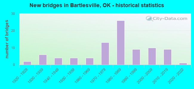
- New bridges - historical statistics
- 21920-1929
- 61930-1939
- 41940-1949
- 41950-1959
- 41960-1969
- 131970-1979
- 261980-1989
- 91990-1999
- 102000-2009
- 92010-2019
- 12020-2022

- Reconstructed bridges - Historical Statistics
- 21970-1979
- 01980-1989
- 11990-1999
- 12000-2009


- Bridge Condition - Deck
- 5.2%Very good
- 48.3%Good
- 36.2%Satisfactory
- 6.9%Fair
- 3.4%Poor

- Bridge Condition - Superstructure
- 1.7%Excellent
- 29.3%Very good
- 27.6%Good
- 20.7%Satisfactory
- 15.5%Fair
- 1.7%Poor
- 1.7%Serious
- 1.7%Critical

- Bridge Condition - Substructure
- 8.6%Very good
- 24.1%Good
- 22.4%Satisfactory
- 27.6%Fair
- 17.2%Poor

- Bridge Condition - Channel
- 1.2%Excellent
- 25.9%Very good
- 22.2%Good
- 28.4%Satisfactory
- 18.5%Fair
- 3.7%Poor

- Bridge Condition - Culverts
- 23.1%Very good
- 46.2%Good
- 23.1%Satisfactory
- 7.7%Fair
Find on map >> Show street view
Structure Number: 31326, Location: 1S 1.5E OF OCHELATA (Lat: 36.583139, Lng: -95.945361), Route carried "on" structure: County highway E0300, Year Built: 1990, Status: Open, Structure Length: 0.76m (2.49ft), Average Daily Traffic: 100 (year 2020), Truck Traffic: 10%, Average Future Daily Traffic: 160 (year 2040), Features Intersected: NORTH FORK CREEK
Minimum Vertical Clearance: 30+ m (98+ ft), Kilometerpoint: 0.805, Lanes on structure: 2, Owner: County Highway Agency, Approaching Roadway Width: 6.7m (22.0ft), Material/Design: Steel, Design/Construction: Stringer/Multi-beam, Number Of Spans In Main Unit: 1, Length of Maximum Span: 7.3m (24.0ft), Curb-To-Curb Width: 7.7m (25.3ft), Out-to-Out Width: 8.4m (27.6ft)
Condition: Deck: Good, Superstructure: Good, Substructure: Satisfactory, Channel: Good, Operating Rating: 65.2 metric tons, Method Used To Determine Operating Rating: Load Factor (LF), Inventory Rating: 39.1 metric tons, Method Used To Determine Inventory Rating: Load Factor (LF), Structural Evaluation: Equal to present minimum criteria, Deck Geometry: Equal to present minimum criteria, Waterway Adequacy: Better than present minimum criteria, Approach Roadway Alignment: Equal to present desirable criteria, Designated Inspection Frequency: Every 24 months, Inspection Date: November 2020, Deck Structure Type: Concrete Cast-file-Place, Wearing Surface/Protective System: Wearing Surface: Bituminous
Find on map >> Show street view
Structure Number: 31356, Location: .2W OF VIRGINIA (Lat: 36.757058, Lng: -95.993603), Route carried "on" structure: City street E0180, Year Built: 2001, Status: Open, Structure Length: 0.73m (2.40ft), Average Daily Traffic: 200 (year 2020), Truck Traffic: 5%, Average Future Daily Traffic: 320 (year 2040), Design Load: HS 20, Features Intersected: CREEK
Minimum Vertical Clearance: 30+ m (98+ ft), Kilometerpoint: 0.322, Lanes on structure: 2, Owner: City or Municipal Highway Agency, Approaching Roadway Width: 8.5m (27.9ft), Skew: 3 degrees, Material/Design: Concrete, Design/Construction: Culvert, Number Of Spans In Main Unit: 3, Length of Maximum Span: 1.8m (5.9ft), Curb-To-Curb Width: 8.5m (27.9ft), Out-to-Out Width: 9.1m (29.9ft)
Condition: Channel: Very good, Culverts: Satisfactory, Operating Rating: 57.7 metric tons, Method Used To Determine Operating Rating: Load Factor (LF), Inventory Rating: 34.6 metric tons, Method Used To Determine Inventory Rating: Load Factor (LF), Structural Evaluation: Equal to present minimum criteria, Deck Geometry: Equal to present minimum criteria, Waterway Adequacy: Equal to present minimum criteria, Approach Roadway Alignment: Equal to present desirable criteria, Designated Inspection Frequency: Every 24 months, Inspection Date: January 2021, Total Project Cost: $225,000, Wearing Surface/Protective System: Wearing Surface: Bituminous
Find on map >> Show street view
Structure Number: 31406, Location: 3.6 E U.S. 75 (Lat: 36.728056, Lng: -95.869722), Route carried "on" structure: US 60, Year Built: 2021, Status: Open, Structure Length: 0.82m (2.69ft), Average Daily Traffic: 5,800 (year 2020), Truck Traffic: 9%, Average Future Daily Traffic: 8,000 (year 2040), Design Load: HL 93, Features Intersected: FISH CREEK
Minimum Vertical Clearance: 30+ m (98+ ft), Kilometerpoint: 9.347, Lanes on structure: 2, Owner: State Highway Agency, Approaching Roadway Width: 12.2m (40.0ft), Skew: 4 degrees, Material/Design: Concrete, Design/Construction: Culvert, Number Of Spans In Main Unit: 2, Length of Maximum Span: 3.7m (12.1ft)
Condition: Channel: Very good, Culverts: Very good, Operating Rating: 43.3 metric tons, Method Used To Determine Operating Rating: Load and Resistance Factor (LRFR), Inventory Rating: 33.4 metric tons, Method Used To Determine Inventory Rating: Load and Resistance Factor (LRFR), Structural Evaluation: Equal to present desirable criteria, Waterway Adequacy: Equal to present desirable criteria, Approach Roadway Alignment: Equal to present desirable criteria, Designated Inspection Frequency: Every 24 months, Inspection Date: October 2021
Find on map >> Show street view
Structure Number: 31703, Location: 3W 4.8S OF JCT US75/US60 (Lat: 36.657986, Lng: -95.989375), Route carried "on" structure: County highway N3940, Year Built: 2017, Status: Open, Structure Length: 2.53m (8.30ft), Average Daily Traffic: 100 (year 2020), Truck Traffic: 10%, Average Future Daily Traffic: 160 (year 2040), Design Load: HS 20, Features Intersected: CREEK
Minimum Vertical Clearance: 30+ m (98+ ft), Kilometerpoint: 1.287, Lanes on structure: 2, Owner: County Highway Agency, Approaching Roadway Width: 7.9m (25.9ft), Material/Design: Prestressed concrete, Design/Construction: Stringer/Multi-beam, Number Of Spans In Main Unit: 1, Length of Maximum Span: 25.3m (83.0ft), Curb-To-Curb Width: 7.9m (25.9ft), Out-to-Out Width: 8.6m (28.2ft)
Condition: Deck: Good, Superstructure: Very good, Substructure: Good, Channel: Fair, Operating Rating: 82.0 metric tons, Method Used To Determine Operating Rating: Load Factor (LF), Inventory Rating: 40.3 metric tons, Method Used To Determine Inventory Rating: Load Factor (LF), Structural Evaluation: Better than present minimum criteria, Deck Geometry: Equal to present minimum criteria, Waterway Adequacy: Equal to present desirable criteria, Approach Roadway Alignment: Better than present minimum criteria, Designated Inspection Frequency: Every 24 months, Inspection Date: November 2020, Deck Structure Type: Concrete Cast-file-Place, Wearing Surface/Protective System: Wearing Surface: Monolithic Concrete
Find on map >> Show street view
Structure Number: 32324, Location: .25S of CUDAHY ST. (Lat: 36.754311, Lng: -95.993056), Route carried "on" structure: City street E0181, Year Built: 2018, Status: Open, Structure Length: 0.61m (2.00ft), Average Daily Traffic: 200 (year 2020), Truck Traffic: 5%, Average Future Daily Traffic: 320 (year 2040), Design Load: HS 20, Features Intersected: CREEK
Minimum Vertical Clearance: 30+ m (98+ ft), Kilometerpoint: 0.518, Lanes on structure: 2, Owner: City or Municipal Highway Agency, Approaching Roadway Width: 8.5m (27.9ft), Material/Design: Concrete, Design/Construction: Culvert, Number Of Spans In Main Unit: 3, Length of Maximum Span: 1.8m (5.9ft), Curb-To-Curb Width: 9.3m (30.5ft), Out-to-Out Width: 10.0m (32.8ft)
Condition: Channel: Very good, Culverts: Good, Operating Rating: 57.2 metric tons, Method Used To Determine Operating Rating: Load Factor (LF), Inventory Rating: 34.3 metric tons, Method Used To Determine Inventory Rating: Load Factor (LF), Structural Evaluation: Better than present minimum criteria, Deck Geometry: Equal to present minimum criteria, Waterway Adequacy: Better than present minimum criteria, Approach Roadway Alignment: Equal to present desirable criteria, Designated Inspection Frequency: Every 24 months, Inspection Date: January 2021, Total Project Cost: $225,000, Wearing Surface/Protective System: Wearing Surface: Bituminous
Find on map >> Show street view
Structure Number: 32325, Location: .25N of MCNAMARA ST. (Lat: 36.755394, Lng: -95.992911), Route carried "on" structure: City street E0182, Year Built: 2018, Status: Open, Structure Length: 0.61m (2.00ft), Average Daily Traffic: 200 (year 2020), Truck Traffic: 5%, Average Future Daily Traffic: 320 (year 2040), Design Load: HS 20, Features Intersected: CREEK
Minimum Vertical Clearance: 30+ m (98+ ft), Kilometerpoint: 0.518, Lanes on structure: 2, Owner: City or Municipal Highway Agency, Approaching Roadway Width: 8.5m (27.9ft), Material/Design: Concrete, Design/Construction: Culvert, Number Of Spans In Main Unit: 3, Length of Maximum Span: 1.8m (5.9ft), Curb-To-Curb Width: 9.2m (30.2ft), Out-to-Out Width: 9.8m (32.2ft)
Condition: Channel: Very good, Culverts: Satisfactory, Operating Rating: 55.1 metric tons, Method Used To Determine Operating Rating: Load Factor (LF), Inventory Rating: 33.0 metric tons, Method Used To Determine Inventory Rating: Load Factor (LF), Structural Evaluation: Equal to present minimum criteria, Deck Geometry: Equal to present minimum criteria, Waterway Adequacy: Better than present minimum criteria, Approach Roadway Alignment: Equal to present desirable criteria, Designated Inspection Frequency: Every 24 months, Inspection Date: January 2021, Total Project Cost: $225,000, Wearing Surface/Protective System: Wearing Surface: Bituminous
Find on map >> Show street view
Structure Number: 18066, Location: 3.7 MI E OSAGE CO (Lat: 36.742425, Lng: -95.935592), Route carried "under" structure: US 75, Year Built: 1971, Structure Length: 0. m, Average Daily Traffic: 22,600 (year 2020), Truck Traffic: 7%, Features Intersected: U.S. 75 UNDER, Facility Carried by Structure: U.S. 60
Minimum Vertical Clearance: 4.47m (14.67ft), Kilometerpoint: 1.609, Lanes on structure: 4, Lanes under structure: 5, Material/Design: Steel continuous, Design/Construction: Stringer/Multi-beam, Length of Maximum Span: 23.2m (76.1ft)
Find on map >> Show street view
Structure Number: 21328, Location: 5.5 MI S JCT US 60 (Lat: 36.655350, Lng: -95.935617), Route carried "under" structure: County highway , Year Built: 1986, Structure Length: 0. m, Average Daily Traffic: 100 (year 2020), Truck Traffic: 15%, Features Intersected: CANEY RI O'FL-CO RD UND, Facility Carried by Structure: U.S. 75
Minimum Vertical Clearance: 5.11m (16.77ft), Kilometerpoint: 25.630, Lanes on structure: 2, Lanes under structure: 2, Material/Design: Prestressed concrete, Design/Construction: Tee Beam, Length of Maximum Span: 13.7m (44.9ft)
Find on map >> Show street view
Structure Number: 21692, Location: 5.5 MI S US 60 (Lat: 36.655353, Lng: -95.935158), Route carried "under" structure: County highway , Year Built: 1987, Structure Length: 0. m, Average Daily Traffic: 100 (year 2020), Truck Traffic: 15%, Features Intersected: CANEY RI O'FL-CO RD UND, Facility Carried by Structure: U.S. 75
Minimum Vertical Clearance: 5.11m (16.77ft), Kilometerpoint: 25.630, Lanes on structure: 2, Lanes under structure: 2, Material/Design: Prestressed concrete, Design/Construction: Tee Beam, Length of Maximum Span: 13.7m (44.9ft)
Find on map >> Show street view
Structure Number: 27157, Location: E. OF OCHELATA (Lat: 36.583111, Lng: -95.930436), Route carried "under" structure: US 75, Year Built: 2004, Structure Length: 0. m, Average Daily Traffic: 13,900 (year 2020), Truck Traffic: 25%, Features Intersected: U.S. 75 UNDER, Facility Carried by Structure: OCHELATA RD.
Minimum Vertical Clearance: 5.33m (17.49ft), Kilometerpoint: 17.700, Lanes on structure: 2, Lanes under structure: 4, Material/Design: Prestressed concrete, Design/Construction: Stringer/Multi-beam, Length of Maximum Span: 27.4m (89.9ft)