Bridge Statistics for Bel Air North, Maryland (MD)
Condition, Traffic, Stress, Structural Evaluation, Project Costs
- National Bridge Inventory (NBI) Statistics
- 48Number of bridges
- 328ft / 100mTotal length
- $4,115,000Total costs
- 350,877Total average daily traffic
- 19,929Total average daily truck traffic
- National Bridge Inventory (NBI) Registered Bridges for Bel Air North
- No street view available for this location
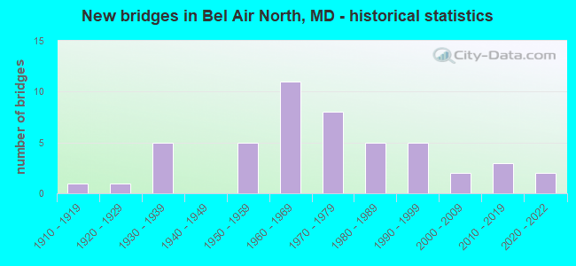
- New bridges - historical statistics
- 11910-1919
- 11920-1929
- 51930-1939
- 51950-1959
- 111960-1969
- 81970-1979
- 51980-1989
- 51990-1999
- 22000-2009
- 32010-2019
- 22020-2022

- Reconstructed bridges - Historical Statistics
- 11960-1969
- 11970-1979
- 41980-1989
- 21990-1999
- 02000-2009
- 12010-2019


- Bridge Condition - Deck
- 6.9%Very good
- 44.8%Good
- 37.9%Satisfactory
- 3.4%Fair
- 6.9%Poor

- Bridge Condition - Superstructure
- 27.6%Very good
- 24.1%Good
- 27.6%Satisfactory
- 20.7%Fair

- Bridge Condition - Substructure
- 10.3%Very good
- 37.9%Good
- 34.5%Satisfactory
- 13.8%Fair
- 3.4%Poor

- Bridge Condition - Channel
- 10.0%Very good
- 42.5%Good
- 40.0%Satisfactory
- 7.5%Fair

- Bridge Condition - Culverts
- 33.3%Good
- 53.3%Satisfactory
- 13.3%Fair
Find on map >> Show street view
Structure Number: 10000012001501, Location: 0.26 M S OF RED PUMP ROAD (Lat: 39.554689, Lng: -76.367608), Route carried "under" structure: State highway 24, Year Built: 1964, Structure Length: 0. m, Average Daily Traffic: 36,202 (year 2009), Features Intersected: MD 24, Facility Carried by Structure: US 1
Minimum Vertical Clearance: 5.18m (16.99ft), Kilometerpoint: 18.584, Lanes on structure: 3, Lanes under structure: 3, Material/Design: Steel, Design/Construction: Stringer/Multi-beam, Length of Maximum Span: 24.4m (80.1ft)
Find on map >> Show street view
Structure Number: 10000012006301, Location: 1.97 MILES S OF MD 165 (Lat: 39.576428, Lng: -76.438778), Route carried "under" structure: County highway 62, Year Built: 1961, Structure Length: 0. m, Features Intersected: PHILLIPS MILL ROAD, Facility Carried by Structure: MD 23
Minimum Vertical Clearance: 13.72m (45.01ft), Kilometerpoint: 1.947, Lanes on structure: 2, Lanes under structure: 2, Material/Design: Steel, Design/Construction: Stringer/Multi-beam, Length of Maximum Span: 22.3m (73.2ft)
Find on map >> Show street view
Structure Number: 10000012006601, Location: 1.44 MILES N OF MD 147 (Lat: 39.526072, Lng: -76.368883), Route carried "under" structure: County highway 1996, Year Built: 1963, Structure Length: 0. m, Average Daily Traffic: 8,071 (year 2009), Features Intersected: N TOLLGATE ROAD, Facility Carried by Structure: US 1
Minimum Vertical Clearance: 6.71m (22.01ft), Kilometerpoint: 1.464, Lanes on structure: 3, Lanes under structure: 2, Material/Design: Steel, Design/Construction: Stringer/Multi-beam, Length of Maximum Span: 13.7m (44.9ft)
Find on map >> Show street view
Structure Number: 10000012006701, Location: 0.74 MILE NORTH OF MD 24 (Lat: 39.543767, Lng: -76.369486), Route carried "under" structure: US 1, Year Built: 1963, Structure Length: 0. m, Average Daily Traffic: 36,122 (year 2009), Features Intersected: US I, Facility Carried by Structure: VALE ROAD
Minimum Vertical Clearance: 5.18m (16.99ft), Kilometerpoint: 8.608, Lanes on structure: 2, Lanes under structure: 4, Material/Design: Steel, Design/Construction: Stringer/Multi-beam, Length of Maximum Span: 23.5m (77.1ft)