Bridge Statistics for Bucyrus, Ohio (OH)
Condition, Traffic, Stress, Structural Evaluation, Project Costs
- New bridges - historical statistics
- 11930-1939
- 11950-1959
- 71960-1969
- 271970-1979
- 31980-1989
- 41990-1999
- 192000-2009
- Reconstructed bridges - Historical Statistics
- 11980-1989
- 41990-1999
- 02000-2009
- 22010-2019
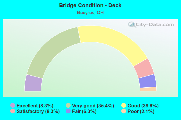
- Bridge Condition - Deck
- 8.3%Excellent
- 35.4%Very good
- 39.6%Good
- 8.3%Satisfactory
- 6.3%Fair
- 2.1%Poor
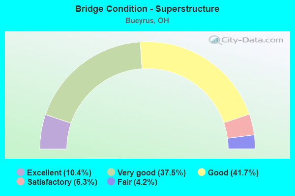
- Bridge Condition - Superstructure
- 10.4%Excellent
- 37.5%Very good
- 41.7%Good
- 6.3%Satisfactory
- 4.2%Fair
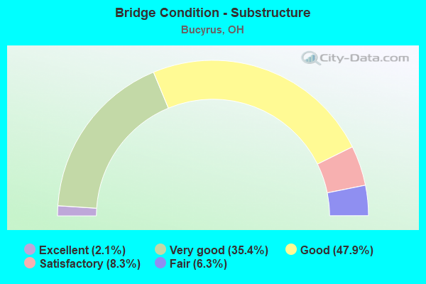
- Bridge Condition - Substructure
- 2.1%Excellent
- 35.4%Very good
- 47.9%Good
- 8.3%Satisfactory
- 6.3%Fair
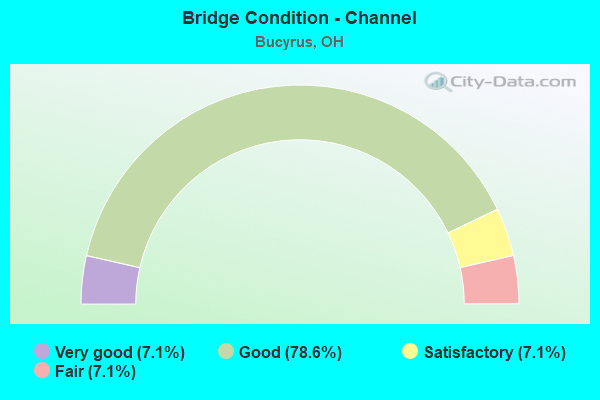
- Bridge Condition - Channel
- 7.1%Very good
- 78.6%Good
- 7.1%Satisfactory
- 7.1%Fair
Find on map >> Show street view
Structure Number: 1744259, Location: 0.7 MI N OF WYANDOT RD (Lat: 40.789439, Lng: -83.026669), Route carried "on" structure: County highway T0117, Year Built: 2001, Status: Open, Structure Length: 3.05m (10.01ft), Average Daily Traffic: 324 (year 2015), Truck Traffic: 7%, Average Future Daily Traffic: 450 (year 2035), Design Load: HS 20+Mod, Features Intersected: SANDUSKY RIVER, Facility Carried by Structure: DENZER ROAD
Minimum Vertical Clearance: 30+ m (98+ ft), Kilometerpoint: 3.862, Lanes on structure: 2, Owner: County Highway Agency, Approaching Roadway Width: 7.3m (24.0ft), Material/Design: Prestressed concrete, Design/Construction: Box Beam or Girders - Multiple, Number Of Spans In Main Unit: 3, Length of Maximum Span: 10.4m (34.1ft), Curb-To-Curb Width: 7.3m (24.0ft), Out-to-Out Width: 7.3m (24.0ft)
Condition: Deck: Very good, Superstructure: Excellent, Substructure: Excellent, Channel: Good, Operating Rating: 64.8 metric tons, Method Used To Determine Operating Rating: Load Factor (LF) rating reported by rating factor (RF) method using MS18 loading, Inventory Rating: 38.9 metric tons, Method Used To Determine Inventory Rating: Load Factor (LF) rating reported by rating factor (RF) method using MS18 loading, Structural Evaluation: Superior to present desirable criteria, Deck Geometry: Somewhat better than minimum adequacy, Waterway Adequacy: Equal to present desirable criteria, Approach Roadway Alignment: Equal to present desirable criteria, Designated Inspection Frequency: Every 24 months, Inspection Date: September 2020, Deck Structure Type: Concrete Cast-file-Place, Wearing Surface/Protective System: Wearing Surface: Bituminous, Membrane: Preformed Fabric
Find on map >> Show street view
Structure Number: 1744305, Location: 1.8 MILES WEST OF SR-4 (Lat: 40.803611, Lng: -83.005831), Route carried "on" structure: County highway C0121, Year Built: 2000, Status: Open, Structure Length: 3.20m (10.50ft), Average Daily Traffic: 1,949 (year 2015), Truck Traffic: 5%, Average Future Daily Traffic: 2,705 (year 2035), Design Load: HS 20+Mod, Features Intersected: SANDUSKY RIVER, Facility Carried by Structure: KERSTETTER ROAD
Minimum Vertical Clearance: 30+ m (98+ ft), Kilometerpoint: 0.080, Lanes on structure: 2, Owner: County Highway Agency, Approaching Roadway Width: 9.1m (29.9ft), Skew: 1 degrees, Material/Design: Concrete continuous, Design/Construction: Slab, Number Of Spans In Main Unit: 3, Length of Maximum Span: 12.2m (40.0ft), Curb-To-Curb Width: 9.3m (30.5ft), Out-to-Out Width: 9.3m (30.5ft)
Condition: Deck: Very good, Superstructure: Very good, Substructure: Very good, Channel: Good, Operating Rating: 71.3 metric tons, Method Used To Determine Operating Rating: Load Factor (LF) rating reported by rating factor (RF) method using MS18 loading, Inventory Rating: 42.1 metric tons, Method Used To Determine Inventory Rating: Load Factor (LF) rating reported by rating factor (RF) method using MS18 loading, Structural Evaluation: Equal to present desirable criteria, Deck Geometry: Somewhat better than minimum adequacy, Waterway Adequacy: Equal to present desirable criteria, Approach Roadway Alignment: Equal to present desirable criteria, Designated Inspection Frequency: Every 24 months, Inspection Date: September 2020, Deck Structure Type: Concrete Cast-file-Place, Wearing Surface/Protective System: Wearing Surface: Monolithic Concrete, Membrane: Epoxy, Deck Protection: Epoxy Coated Reinforcing
Find on map >> Show street view
Structure Number: 174519, Location: 0.1 MI S OF TR 34 (Lat: 40.738331, Lng: -82.915000), Route carried "on" structure: County highway T0157, Year Built: 1990, Status: Open, Structure Length: 4.45m (14.60ft), Average Daily Traffic: 351 (year 2015), Truck Traffic: 7%, Average Future Daily Traffic: 487 (year 2035), Design Load: HS 20+Mod, Features Intersected: OLENTANGY RIVER, Facility Carried by Structure: POE ROAD
Minimum Vertical Clearance: 30+ m (98+ ft), Kilometerpoint: 1.642, Lanes on structure: 2, Owner: County Highway Agency, Approaching Roadway Width: 6.1m (20.0ft), Skew: 2 degrees, Material/Design: Prestressed concrete, Design/Construction: Box Beam or Girders - Multiple, Number Of Spans In Main Unit: 3, Length of Maximum Span: 14.3m (46.9ft), Curb-To-Curb Width: 7.3m (24.0ft), Out-to-Out Width: 7.3m (24.0ft)
Condition: Deck: Very good, Superstructure: Very good, Substructure: Very good, Channel: Good, Operating Rating: 81.0 metric tons, Method Used To Determine Operating Rating: Load Factor (LF) rating reported by rating factor (RF) method using MS18 loading, Inventory Rating: 48.6 metric tons, Method Used To Determine Inventory Rating: Load Factor (LF) rating reported by rating factor (RF) method using MS18 loading, Structural Evaluation: Equal to present desirable criteria, Deck Geometry: Somewhat better than minimum adequacy, Waterway Adequacy: Equal to present minimum criteria, Approach Roadway Alignment: Better than present minimum criteria, Designated Inspection Frequency: Every 24 months, Inspection Date: November 2021, Deck Structure Type: Concrete Cast-file-Place, Wearing Surface/Protective System: Wearing Surface: Bituminous, Membrane: Built-up
Find on map >> Show street view
Structure Number: 1746723, Location: 0.5 MI. N. OF CR 12 (Lat: 40.768331, Lng: -83.055000), Route carried "on" structure: County highway T0214, Year Built: 1988, Status: Open, Structure Length: 5.33m (17.49ft), Average Daily Traffic: 139 (year 2015), Truck Traffic: 7%, Average Future Daily Traffic: 193 (year 2035), Design Load: HS 20+Mod, Features Intersected: SANDUSKY RIVER, Facility Carried by Structure: SHUPP ROAD
Minimum Vertical Clearance: 30+ m (98+ ft), Kilometerpoint: 2.462, Lanes on structure: 2, Owner: County Highway Agency, Approaching Roadway Width: 8.5m (27.9ft), Skew: 3 degrees, Material/Design: Steel continuous, Design/Construction: Stringer/Multi-beam, Number Of Spans In Main Unit: 3, Length of Maximum Span: 19.8m (65.0ft), Curb-To-Curb Width: 7.3m (24.0ft), Out-to-Out Width: 7.3m (24.0ft)
Condition: Deck: Very good, Superstructure: Very good, Substructure: Very good, Channel: Very good, Operating Rating: 48.6 metric tons, Method Used To Determine Operating Rating: Load Factor (LF) rating reported by rating factor (RF) method using MS18 loading, Inventory Rating: 29.2 metric tons, Method Used To Determine Inventory Rating: Load Factor (LF) rating reported by rating factor (RF) method using MS18 loading, Structural Evaluation: Better than present minimum criteria, Deck Geometry: Somewhat better than minimum adequacy, Waterway Adequacy: Equal to present minimum criteria, Approach Roadway Alignment: Equal to present desirable criteria, Designated Inspection Frequency: Every 24 months, Inspection Date: September 2020, Deck Structure Type: Concrete Cast-file-Place, Wearing Surface/Protective System: Wearing Surface: Monolithic Concrete, Deck Protection: Epoxy Coated Reinforcing
Find on map >> Show street view
Structure Number: 1746995, Location: 0.2 MI. E. OF US 30 (Lat: 40.825969, Lng: -83.038431), Route carried "on" structure: County highway C0330, Year Built: 1969, Status: Open, Structure Length: 2.23m (7.32ft), Average Daily Traffic: 2,726 (year 2015), Truck Traffic: 7%, Average Future Daily Traffic: 3,784 (year 2035), Design Load: H 20, Features Intersected: GRASS RUN, Facility Carried by Structure: LINCOLN HIGHWAY
Minimum Vertical Clearance: 30+ m (98+ ft), Kilometerpoint: 6.791, Lanes on structure: 2, Owner: County Highway Agency, Approaching Roadway Width: 9.1m (29.9ft), Skew: 2 degrees, Material/Design: Concrete continuous, Design/Construction: Slab, Number Of Spans In Main Unit: 3, Length of Maximum Span: 8.5m (27.9ft), Curb-To-Curb Width: 13.4m (44.0ft), Out-to-Out Width: 13.4m (44.0ft)
Condition: Deck: Good, Superstructure: Fair, Substructure: Satisfactory, Channel: Good, Operating Rating: 61.6 metric tons, Method Used To Determine Operating Rating: Load Factor (LF) rating reported by rating factor (RF) method using MS18 loading, Inventory Rating: 35.6 metric tons, Method Used To Determine Inventory Rating: Load Factor (LF) rating reported by rating factor (RF) method using MS18 loading, Structural Evaluation: Somewhat better than minimum adequacy, Deck Geometry: Better than present minimum criteria, Waterway Adequacy: Equal to present desirable criteria, Approach Roadway Alignment: Superior to present desirable criteria, Designated Inspection Frequency: Every 12 months, Inspection Date: November 2021, Deck Structure Type: Concrete Cast-file-Place, Wearing Surface/Protective System: Wearing Surface: Integral Concrete, Membrane: Preformed Fabric
Find on map >> Show street view
Structure Number: 1747118, Location: 0.3 MI. W. OF SR 4 (Lat: 40.809111, Lng: -82.982161), Route carried "on" structure: City street S0890, Year Built: 1933, Year Reconstructed: 1988, Status: Open, Structure Length: 3.90m (12.80ft), Average Daily Traffic: 3,764 (year 2015), Truck Traffic: 6%, Average Future Daily Traffic: 5,224 (year 2035), Design Load: HS 20+Mod, Features Intersected: SANDUSKY RIVER MANS ST, Facility Carried by Structure: W. MANSFIELD ST
Minimum Vertical Clearance: 30+ m (98+ ft), Kilometerpoint: 11.909, Lanes on structure: 2, Owner: County Highway Agency, Approaching Roadway Width: 11.0m (36.1ft), Skew: 4 degrees, Material/Design: Prestressed concrete continuous, Design/Construction: Box Beam or Girders - Multiple, Number Of Spans In Main Unit: 2, Length of Maximum Span: 18.9m (62.0ft), Curb or Sidewalk Widths: Left: 1.5m (4.9ft), Right: 1.5m (4.9ft), Curb-To-Curb Width: 11.0m (36.1ft), Out-to-Out Width: 14.6m (47.9ft)
Condition: Deck: Good, Superstructure: Good, Substructure: Good, Channel: Satisfactory, Operating Rating: 58.3 metric tons, Method Used To Determine Operating Rating: Load Factor (LF) rating reported by rating factor (RF) method using MS18 loading, Inventory Rating: 35.6 metric tons, Method Used To Determine Inventory Rating: Load Factor (LF) rating reported by rating factor (RF) method using MS18 loading, Structural Evaluation: Better than present minimum criteria, Deck Geometry: Somewhat better than minimum adequacy, Waterway Adequacy: Superior to present desirable criteria, Approach Roadway Alignment: Better than present minimum criteria, Length Of Structure Improvement: 3.96m (12.99ft), Designated Inspection Frequency: Every 24 months, Inspection Date: September 2020, Bridge Improvement Cost: $165,000, Roadway Improvement Cost: $17,000, Total Project Cost: $200,000 ( Estimate for 2019), Deck Structure Type: Concrete Cast-file-Place, Wearing Surface/Protective System: Wearing Surface: Monolithic Concrete, Deck Protection: Epoxy Coated Reinforcing
Find on map >> Show street view
Structure Number: 1760009, Location: 0.2 MI. W. OF SR4 BUCYRUS (Lat: 40.810800, Lng: -82.979481), Route carried "on" structure: City street WMARY, Year Built: 1964, Year Reconstructed: 1995, Status: Open, Structure Length: 4.24m (13.91ft), Average Daily Traffic: 1,689 (year 2015), Truck Traffic: 3%, Average Future Daily Traffic: 2,344 (year 2035), Features Intersected: SANDUSKY RIVER, Facility Carried by Structure: W. MARY STREET
Minimum Vertical Clearance: 30+ m (98+ ft), Kilometerpoint: 0.684, Lanes on structure: 2, Owner: City or Municipal Highway Agency, Approaching Roadway Width: 9.4m (30.8ft), Skew: 2 degrees, Material/Design: Prestressed concrete continuous, Design/Construction: Box Beam or Girders - Multiple, Number Of Spans In Main Unit: 2, Length of Maximum Span: 20.4m (66.9ft), Curb or Sidewalk Widths: Left: 1.5m (4.9ft), Right: 0.0m, Curb-To-Curb Width: 10.0m (32.8ft), Out-to-Out Width: 12.5m (41.0ft)
Condition: Deck: Satisfactory, Superstructure: Good, Substructure: Fair, Channel: Good, Operating Rating: 48.6 metric tons, Method Used To Determine Operating Rating: Load Factor (LF) rating reported by rating factor (RF) method using MS18 loading, Inventory Rating: 16.2 metric tons, Method Used To Determine Inventory Rating: Load Factor (LF) rating reported by rating factor (RF) method using MS18 loading, Structural Evaluation: Meets minimum limits, Deck Geometry: Somewhat better than minimum adequacy, Waterway Adequacy: Equal to present desirable criteria, Approach Roadway Alignment: Equal to present desirable criteria, Designated Inspection Frequency: Every 12 months, Inspection Date: July 2021, Deck Structure Type: Concrete Cast-file-Place, Wearing Surface/Protective System: Wearing Surface: Monolithic Concrete, Deck Protection: Epoxy Coated Reinforcing
Find on map >> Show street view
Structure Number: 1760068, Location: 0.3 MI S. OF SR98 (Lat: 40.811739, Lng: -82.971950), Route carried "on" structure: City street NLANE, Year Built: 1968, Year Reconstructed: 1996, Status: Open, Structure Length: 3.54m (11.61ft), Average Daily Traffic: 3,675 (year 2015), Truck Traffic: 5%, Average Future Daily Traffic: 5,101 (year 2035), Design Load: HS 20+Mod, Features Intersected: SANDUSKY RIVER, Facility Carried by Structure: N. LANE STREET
Minimum Vertical Clearance: 30+ m (98+ ft), Kilometerpoint: 0.779, Lanes on structure: 2, Owner: City or Municipal Highway Agency, Approaching Roadway Width: 8.5m (27.9ft), Material/Design: Steel continuous, Design/Construction: Stringer/Multi-beam, Number Of Spans In Main Unit: 2, Length of Maximum Span: 17.7m (58.1ft), Curb or Sidewalk Widths: Left: 1.5m (4.9ft), Right: 1.5m (4.9ft), Curb-To-Curb Width: 8.5m (27.9ft), Out-to-Out Width: 12.2m (40.0ft)
Condition: Deck: Very good, Superstructure: Very good, Substructure: Very good, Channel: Satisfactory, Operating Rating: 68.0 metric tons, Method Used To Determine Operating Rating: Load and Resistance Factor Rating (LRFR) rating reported by rating factor(RF) method using HL-93 loadings, Inventory Rating: 51.8 metric tons, Method Used To Determine Inventory Rating: Load and Resistance Factor Rating (LRFR) rating reported by rating factor(RF) method using HL-93 loadings, Structural Evaluation: Equal to present desirable criteria, Deck Geometry: Meets minimum limits, Waterway Adequacy: Better than present minimum criteria, Approach Roadway Alignment: Better than present minimum criteria, Designated Inspection Frequency: Every 24 months, Inspection Date: July 2021, Deck Structure Type: Concrete Cast-file-Place, Wearing Surface/Protective System: Wearing Surface: Monolithic Concrete, Deck Protection: Epoxy Coated Reinforcing
Find on map >> Show street view
Structure Number: 1760653, Location: 450 FT SOUTH OF RIVER ST. (Lat: 40.811850, Lng: -82.977931), Route carried "on" structure: City street 4X09, Year Built: 1976, Status: Open, Structure Length: 3.57m (11.71ft), Average Daily Traffic: 2,369 (year 2019), Truck Traffic: 1%, Average Future Daily Traffic: 3,288 (year 2039), Design Load: HS 20, Features Intersected: SANDUSKY RIVER, Facility Carried by Structure: N POPLAR ST.
Minimum Vertical Clearance: 30+ m (98+ ft), Kilometerpoint: 1.569, Lanes on structure: 2, Owner: City or Municipal Highway Agency, Approaching Roadway Width: 8.5m (27.9ft), Material/Design: Concrete continuous, Design/Construction: Slab, Number Of Spans In Main Unit: 3, Length of Maximum Span: 13.7m (44.9ft), Curb or Sidewalk Widths: Left: 1.5m (4.9ft), Right: 1.5m (4.9ft), Curb-To-Curb Width: 8.5m (27.9ft), Out-to-Out Width: 12.2m (40.0ft)
Condition: Deck: Good, Superstructure: Good, Substructure: Fair, Channel: Good, Operating Rating: 64.8 metric tons, Method Used To Determine Operating Rating: Load Factor (LF) rating reported by rating factor (RF) method using MS18 loading, Inventory Rating: 38.9 metric tons, Method Used To Determine Inventory Rating: Load Factor (LF) rating reported by rating factor (RF) method using MS18 loading, Structural Evaluation: Somewhat better than minimum adequacy, Deck Geometry: Meets minimum limits, Waterway Adequacy: Better than present minimum criteria, Approach Roadway Alignment: Better than present minimum criteria, Designated Inspection Frequency: Every 12 months, Inspection Date: July 2021, Deck Structure Type: Concrete Cast-file-Place, Wearing Surface/Protective System: Wearing Surface: Bituminous
Find on map >> Show street view
Structure Number: 1701045, Location: 3.5 MI.WEST OF SR.4 (Lat: 40.826869, Lng: -83.041339), Route carried "under" structure: County highway 330, Year Built: 2004, Structure Length: 0. m, Average Daily Traffic: 3,185 (year 2015), Truck Traffic: 7%, Features Intersected: UNDER US 30, Facility Carried by Structure: US 30
Minimum Vertical Clearance: 4.67m (15.32ft), Kilometerpoint: 6.534, Lanes on structure: 2, Lanes under structure: 2, Material/Design: Steel, Design/Construction: Stringer/Multi-beam, Length of Maximum Span: 51.3m (168.3ft)
Find on map >> Show street view
Structure Number: 1701177, Location: 2.25 MILES WEST OF SR 4 (Lat: 40.826881, Lng: -83.016489), Route carried "under" structure: US 30, Year Built: 1970, Structure Length: 0. m, Average Daily Traffic: 11,274 (year 2016), Truck Traffic: 39%, Features Intersected: CR-36 HOLMES CENTER RD, Facility Carried by Structure: C36 Holmes Ctr Rd
Minimum Vertical Clearance: 4.70m (15.42ft), Kilometerpoint: 8.449, Lanes on structure: 2, Lanes under structure: 4, Material/Design: Steel continuous, Design/Construction: Stringer/Multi-beam, Length of Maximum Span: 20.6m (67.6ft)
Find on map >> Show street view
Structure Number: 1701266, Location: .49 MI W OF SR 4 (Lat: 40.826839, Lng: -82.983011), Route carried "under" structure: County highway 16, Year Built: 1970, Structure Length: 0. m, Average Daily Traffic: 2,104 (year 2015), Truck Traffic: 1%, Features Intersected: UNDER CRA-030 -0711, Facility Carried by Structure: US 30
Minimum Vertical Clearance: 4.54m (14.90ft), Kilometerpoint: 0.386, Lanes on structure: 2, Lanes under structure: 2, Material/Design: Steel continuous, Design/Construction: Stringer/Multi-beam, Length of Maximum Span: 15.2m (49.9ft)
Find on map >> Show street view
Structure Number: 170129, Location: .49 MI W OF SR 4 (Lat: 40.826589, Lng: -82.982919), Route carried "under" structure: County highway 16, Year Built: 1970, Structure Length: 0. m, Average Daily Traffic: 2,104 (year 2015), Truck Traffic: 1%, Features Intersected: UNDER CRA-030 -0711, Facility Carried by Structure: US 30
Minimum Vertical Clearance: 4.45m (14.60ft), Kilometerpoint: 0.386, Lanes on structure: 2, Lanes under structure: 2, Material/Design: Steel continuous, Design/Construction: Stringer/Multi-beam, Length of Maximum Span: 15.2m (49.9ft)
Find on map >> Show street view
Structure Number: 170132, Location: OVER SR 4 (Lat: 40.826450, Lng: -82.973489), Route carried "under" structure: State highway 4, Year Built: 1970, Structure Length: 0. m, Average Daily Traffic: 7,864 (year 2015), Truck Traffic: 11%, Features Intersected: UNDER CRA-030 -0760L, Facility Carried by Structure: US 30
Minimum Vertical Clearance: 4.57m (14.99ft), Kilometerpoint: 16.641, Lanes on structure: 2, Lanes under structure: 4, Material/Design: Steel continuous, Design/Construction: Stringer/Multi-beam, Length of Maximum Span: 13.4m (44.0ft)
Find on map >> Show street view
Structure Number: 1701355, Location: OVER SR 4 (Lat: 40.826200, Lng: -82.973511), Route carried "under" structure: State highway 4, Year Built: 1970, Structure Length: 0. m, Average Daily Traffic: 7,864 (year 2015), Truck Traffic: 11%, Features Intersected: UNDER CRA-030 -0760R, Facility Carried by Structure: US 30
Minimum Vertical Clearance: 4.67m (15.32ft), Kilometerpoint: 16.608, Lanes on structure: 2, Lanes under structure: 4, Material/Design: Steel continuous, Design/Construction: Stringer/Multi-beam, Length of Maximum Span: 13.4m (44.0ft)
Find on map >> Show street view
Structure Number: 1701509, Location: OVER SR 98 (Lat: 40.825581, Lng: -82.952061), Route carried "under" structure: State highway 98, Year Built: 1970, Structure Length: 0. m, Average Daily Traffic: 2,581 (year 2015), Truck Traffic: 6%, Features Intersected: UNDER CRA-030 -0872L, Facility Carried by Structure: US 30
Minimum Vertical Clearance: 4.80m (15.75ft), Kilometerpoint: 15.031, Lanes on structure: 2, Lanes under structure: 4, Material/Design: Steel continuous, Design/Construction: Stringer/Multi-beam, Length of Maximum Span: 17.4m (57.1ft)
Find on map >> Show street view
Structure Number: 1701533, Location: OVER SR 98 (Lat: 40.825431, Lng: -82.952461), Route carried "under" structure: State highway 98, Year Built: 1970, Structure Length: 0. m, Average Daily Traffic: 2,581 (year 2015), Truck Traffic: 6%, Features Intersected: UNDER CRA-030 -0872R, Facility Carried by Structure: US 30
Minimum Vertical Clearance: 4.85m (15.91ft), Kilometerpoint: 14.999, Lanes on structure: 3, Lanes under structure: 4, Material/Design: Steel continuous, Design/Construction: Stringer/Multi-beam, Length of Maximum Span: 17.4m (57.1ft)
Find on map >> Show street view
Structure Number: 1701584, Location: OVER C.R.330 (OLD U.S.30) (Lat: 40.812881, Lng: -82.933719), Route carried "under" structure: County highway 330, Year Built: 2005, Structure Length: 0. m, Average Daily Traffic: 5,483 (year 2015), Truck Traffic: 6%, Features Intersected: NEW U.S.30, Facility Carried by Structure: NEW US 30
Minimum Vertical Clearance: 5.69m (18.67ft), Kilometerpoint: 16.158, Lanes on structure: 2, Lanes under structure: 4, Material/Design: Steel continuous, Design/Construction: Stringer/Multi-beam, Length of Maximum Span: 38.0m (124.7ft)
Find on map >> Show street view
Structure Number: 1701606, Location: 1.29MI E.OF OLD U.S.30 (Lat: 40.798450, Lng: -82.917881), Route carried "under" structure: County highway 13, Year Built: 2005, Structure Length: 0. m, Average Daily Traffic: 588 (year 2015), Truck Traffic: 7%, Features Intersected: NEW U.S.30, Facility Carried by Structure: NEW US 30
Minimum Vertical Clearance: 4.80m (15.75ft), Kilometerpoint: 0.000, Lanes on structure: 2, Lanes under structure: 2, Material/Design: Steel continuous, Design/Construction: Stringer/Multi-beam, Length of Maximum Span: 25.0m (82.0ft)
Find on map >> Show street view
Structure Number: 1701614, Location: OVER C.R.330 (OLD U.S.30) (Lat: 40.812869, Lng: -82.934161), Route carried "under" structure: County highway 330, Year Built: 2005, Structure Length: 0. m, Average Daily Traffic: 5,483 (year 2015), Truck Traffic: 6%, Features Intersected: NEW U.S.30, Facility Carried by Structure: NEW US 30
Minimum Vertical Clearance: 4.85m (15.91ft), Kilometerpoint: 16.110, Lanes on structure: 2, Lanes under structure: 4, Material/Design: Steel continuous, Design/Construction: Stringer/Multi-beam, Length of Maximum Span: 37.9m (124.3ft)
Find on map >> Show street view
Structure Number: 1701622, Location: 2.09 MI E OF SR 4 (Lat: 40.815950, Lng: -82.938581), Route carried "under" structure: US 30, Year Built: 1970, Structure Length: 0. m, Average Daily Traffic: 13,756 (year 2016), Truck Traffic: 28%, Features Intersected: UNDER CRA-45-0050 CR, Facility Carried by Structure: CR 45 Stetzer Rd
Minimum Vertical Clearance: 4.62m (15.16ft), Kilometerpoint: 15.459, Lanes on structure: 2, Lanes under structure: 4, Material/Design: Steel continuous, Design/Construction: Stringer/Multi-beam, Length of Maximum Span: 24.4m (80.1ft)
Find on map >> Show street view
Structure Number: 1701665, Location: 1.29MI E.OF OLD U.S.30 (Lat: 40.798450, Lng: -82.918300), Route carried "under" structure: County highway 13, Year Built: 2005, Structure Length: 0. m, Average Daily Traffic: 588 (year 2015), Truck Traffic: 7%, Features Intersected: NEW U.S.30, Facility Carried by Structure: NEW US 30
Minimum Vertical Clearance: 5.56m (18.24ft), Kilometerpoint: 0.000, Lanes on structure: 2, Lanes under structure: 2, Material/Design: Steel continuous, Design/Construction: Stringer/Multi-beam, Length of Maximum Span: 25.0m (82.0ft)
Find on map >> Show street view
Structure Number: 1701711, Location: 2.50MI W.OF S.R.602 (Lat: 40.784300, Lng: -82.902561), Route carried "under" structure: US 30, Year Built: 2005, Structure Length: 0. m, Average Daily Traffic: 13,670 (year 2016), Truck Traffic: 36%, Features Intersected: CR35 (CRESTLINE RD), Facility Carried by Structure: CR 35 Crestline Rd
Minimum Vertical Clearance: 5.66m (18.57ft), Kilometerpoint: 20.138, Lanes on structure: 2, Lanes under structure: 4, Material/Design: Steel continuous, Design/Construction: Stringer/Multi-beam, Length of Maximum Span: 41.3m (135.5ft)