Bridge Statistics for Byram, Mississippi (MS)
Condition, Traffic, Stress, Structural Evaluation, Project Costs
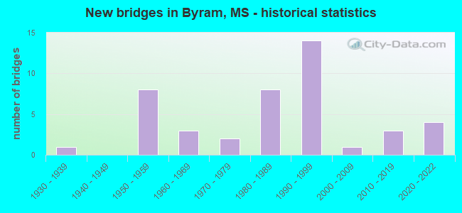
- New bridges - historical statistics
- 11930-1939
- 81950-1959
- 31960-1969
- 21970-1979
- 81980-1989
- 141990-1999
- 12000-2009
- 32010-2019
- 42020-2022

- Reconstructed bridges - Historical Statistics
- 12010-2019
- 12020-2022


- Bridge Condition - Deck
- 8.8%Very good
- 50.0%Good
- 26.5%Satisfactory
- 14.7%Fair

- Bridge Condition - Superstructure
- 26.5%Very good
- 38.2%Good
- 26.5%Satisfactory
- 8.8%Fair

- Bridge Condition - Substructure
- 26.5%Very good
- 35.3%Good
- 8.8%Satisfactory
- 11.8%Fair
- 11.8%Poor
- 2.9%Critical
- 2.9%Imminent failure

- Bridge Condition - Channel
- 30.8%Very good
- 23.1%Good
- 25.6%Satisfactory
- 15.4%Fair
- 5.1%Poor

- Bridge Condition - Culverts
- 50.0%Very good
- 33.3%Good
- 16.7%Satisfactory
Find on map >> Show street view
Structure Number: SA6100000000052, Location: SEC 20 T 4N R 1E B (Lat: 32.169278, Lng: -90.227494), Route carried "on" structure: County highway 425, Year Built: 1988, Status: Open, Structure Length: 12.19m (39.99ft), Average Daily Traffic: 7,300 (year 2020), Truck Traffic: 8%, Average Future Daily Traffic: 10,950 (year 2040), Design Load: HS 20, Features Intersected: PEARL RIVER RELIEF, Facility Carried by Structure: FLORENCE-BYRAM RD.
Minimum Vertical Clearance: 30+ m (98+ ft), Kilometerpoint: 1.770, Lanes on structure: 2, Owner: County Highway Agency, Approaching Roadway Width: 7.3m (24.0ft), Material/Design: Prestressed concrete, Design/Construction: Stringer/Multi-beam, Number Of Spans In Main Unit: 10, Length of Maximum Span: 12.2m (40.0ft), Curb or Sidewalk Widths: Left: 0.5m (1.6ft), Right: 0.5m (1.6ft), Curb-To-Curb Width: 9.1m (29.9ft), Out-to-Out Width: 10.1m (33.1ft)
Condition: Deck: Satisfactory, Superstructure: Satisfactory, Substructure: Good, Channel: Very good, Operating Rating: 62.1 metric tons, Method Used To Determine Operating Rating: Load Factor (LF), Inventory Rating: 37.6 metric tons, Method Used To Determine Inventory Rating: Load Factor (LF), Structural Evaluation: Equal to present minimum criteria, Deck Geometry: Meets minimum limits, Waterway Adequacy: Equal to present minimum criteria, Approach Roadway Alignment: Equal to present desirable criteria, Length Of Structure Improvement: 12.19m (39.99ft), Designated Inspection Frequency: Every 24 months, Inspection Date: November 2020, Bridge Improvement Cost: $728,000, Roadway Improvement Cost: $73,000, Total Project Cost: $897,000 ( Estimate for 2019), Deck Structure Type: Concrete Cast-file-Place, Wearing Surface/Protective System: Wearing Surface: Monolithic Concrete
Find on map >> Show street view
Structure Number: 41000550250841, Location: BYRAM INTERCHANGE (Lat: 32.183989, Lng: -90.257181), Route carried "under" structure: Interstate 55, Year Built: 1993, Structure Length: 0. m, Average Daily Traffic: 24,500 (year 2017), Truck Traffic: 8%, Features Intersected: I 55, Facility Carried by Structure: SIWELL ROAD
Minimum Vertical Clearance: 5.42m (17.78ft), Kilometerpoint: 27.415, Lanes on structure: 4, Lanes under structure: 7, Material/Design: Prestressed concrete continuous, Design/Construction: Stringer/Multi-beam, Length of Maximum Span: 26.2m (86.0ft)
Find on map >> Show street view
Structure Number: 41000550250841, Location: BYRAM INTERCHANGE (Lat: 32.183911, Lng: -90.257061), Route carried "under" structure: Interstate 55, Year Built: 1993, Structure Length: 0. m, Average Daily Traffic: 24,500 (year 2017), Truck Traffic: 8%, Features Intersected: I 55, Facility Carried by Structure: SIWELL ROAD
Minimum Vertical Clearance: 5.24m (17.19ft), Kilometerpoint: 16.847, Lanes on structure: 4, Lanes under structure: 7, Material/Design: Prestressed concrete continuous, Design/Construction: Stringer/Multi-beam, Length of Maximum Span: 26.2m (86.0ft)
Find on map >> Show street view
Structure Number: 41000550250864, Location: 4.9 MI S JCT I55S I20W (Lat: 32.209989, Lng: -90.235800), Route carried "under" structure: Interstate 55, Year Built: 1959, Structure Length: 0. m, Average Daily Traffic: 24,500 (year 2017), Truck Traffic: 8%, Features Intersected: I 55, Facility Carried by Structure: OLD BYRAM ROAD
Minimum Vertical Clearance: 5.04m (16.54ft), Kilometerpoint: 23.859, Lanes on structure: 2, Lanes under structure: 6, Material/Design: Concrete continuous, Design/Construction: Box Beam or Girders - Single/Spread, Length of Maximum Span: 20.4m (66.9ft)
Find on map >> Show street view
Structure Number: 41000550250864, Location: 4.9 MI S JCT I55S I20W (Lat: 32.209881, Lng: -90.235731), Route carried "under" structure: Interstate 55, Year Built: 1959, Structure Length: 0. m, Average Daily Traffic: 24,500 (year 2017), Truck Traffic: 8%, Features Intersected: I 55, Facility Carried by Structure: OLD BYRAM ROAD
Minimum Vertical Clearance: 4.87m (15.98ft), Kilometerpoint: 20.398, Lanes on structure: 2, Lanes under structure: 6, Material/Design: Concrete continuous, Design/Construction: Box Beam or Girders - Single/Spread, Length of Maximum Span: 20.4m (66.9ft)