Bridge Statistics for Campbellsville, Kentucky (KY)
Condition, Traffic, Stress, Structural Evaluation, Project Costs
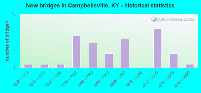
- New bridges - historical statistics
- 11920-1929
- 11930-1939
- 11940-1949
- 91950-1959
- 71960-1969
- 41970-1979
- 81980-1989
- 112000-2009
- 42010-2019
- 12020-2022

- Reconstructed bridges - Historical Statistics
- 11950-1959
- 01960-1969
- 01970-1979
- 01980-1989
- 01990-1999
- 02000-2009
- 02010-2019
- 12020-2022


- Bridge Condition - Deck
- 18.2%Very good
- 54.5%Good
- 15.2%Satisfactory
- 9.1%Fair
- 3.0%Poor

- Bridge Condition - Superstructure
- 33.3%Very good
- 45.5%Good
- 12.1%Satisfactory
- 9.1%Fair

- Bridge Condition - Substructure
- 18.2%Very good
- 63.6%Good
- 9.1%Satisfactory
- 9.1%Fair

- Bridge Condition - Channel
- 2.2%Very good
- 86.7%Good
- 8.9%Satisfactory
- 2.2%Fair

- Bridge Condition - Culverts
- 76.9%Good
- 15.4%Satisfactory
- 7.7%Fair
Find on map >> Show street view
Structure Number: 109C00069N, Location: 0.75 Miles SW of KY 55 (Lat: 37.245000, Lng: -85.364167), Route carried "on" structure: County highway 1236, Year Built: 2016, Status: Posted for load, Structure Length: 5.15m (16.90ft), Average Daily Traffic: 64 (year 2016), Average Future Daily Traffic: 2,036 (year 2036), Design Load: Greater than HL93, Features Intersected: Green River, Facility Carried by Structure: Tebbs Bend Rd.
Minimum Vertical Clearance: 5.49m (18.01ft), Kilometerpoint: 3.758, Lanes on structure: 1, Owner: County Highway Agency, Approaching Roadway Width: 5.8m (19.0ft), Material/Design: Steel, Design/Construction: Truss - Thru, Number Of Spans In Main Unit: 1, Length of Maximum Span: 49.1m (161.1ft), Curb-To-Curb Width: 4.6m (15.1ft), Out-to-Out Width: 5.6m (18.4ft)
Condition: Deck: Very good, Superstructure: Good, Substructure: Good, Channel: Good, Operating Rating: 56.4 metric tons, Method Used To Determine Operating Rating: Load and Resistance Factor Rating (LRFR) rating reported by rating factor(RF) method using HL-93 loadings, Inventory Rating: 43.4 metric tons, Method Used To Determine Inventory Rating: Load and Resistance Factor Rating (LRFR) rating reported by rating factor(RF) method using HL-93 loadings, Structural Evaluation: Better than present minimum criteria, Deck Geometry: Better than present minimum criteria, Waterway Adequacy: Better than present minimum criteria, Approach Roadway Alignment: Meets minimum limits, Designated Inspection Frequency: Every 12 months, Critical Feature Inspection Frequency: Every 24 months, Inspection Date: August 2021, Critical Feature Inspection Date: August 2020, Deck Structure Type: Concrete Cast-file-Place, Wearing Surface/Protective System: Wearing Surface: Monolithic Concrete, Deck Protection: Epoxy Coated Reinforcing
Find on map >> Show street view
Structure Number: 109C00071N, Location: 1.4 Mi NE Jct KY 210 (Lat: 37.382228, Lng: -85.380875), Route carried "on" structure: County highway 1203, Year Built: 2001, Status: Open, Structure Length: 1.52m (4.99ft), Average Daily Traffic: 48 (year 2017), Average Future Daily Traffic: 2,037 (year 2037), Design Load: HS 25 or greater, Features Intersected: Middle Pitman Creek, Facility Carried by Structure: Salem Church Rd
Minimum Vertical Clearance: 30+ m (98+ ft), Kilometerpoint: 2.087, Lanes on structure: 2, Owner: County Highway Agency, Approaching Roadway Width: 5.5m (18.0ft), Material/Design: Prestressed concrete, Design/Construction: Box Beam or Girders - Multiple, Number Of Spans In Main Unit: 1, Length of Maximum Span: 14.3m (46.9ft), Curb or Sidewalk Widths: Left: 0.2m (0.7ft), Right: 0.2m (0.7ft), Curb-To-Curb Width: 6.9m (22.6ft), Out-to-Out Width: 7.3m (24.0ft)
Condition: Deck: Good, Superstructure: Good, Substructure: Good, Channel: Good, Operating Rating: 81.5 metric tons, Method Used To Determine Operating Rating: Load Factor (LF), Inventory Rating: 48.9 metric tons, Method Used To Determine Inventory Rating: Load Factor (LF), Structural Evaluation: Better than present minimum criteria, Deck Geometry: Somewhat better than minimum adequacy, Waterway Adequacy: Somewhat better than minimum adequacy, Approach Roadway Alignment: Equal to present minimum criteria, Designated Inspection Frequency: Every 24 months, Inspection Date: August 2021, Deck Structure Type: Concrete Precast Panels, Wearing Surface/Protective System: Wearing Surface: Monolithic Concrete
Find on map >> Show street view
Structure Number: 109C00072N, Location: 50' W of Jct KY 289 (Lat: 37.394039, Lng: -85.360181), Route carried "on" structure: County highway 1362, Year Built: 2017, Status: Open, Structure Length: 1.10m (3.61ft), Average Daily Traffic: 48 (year 2017), Average Future Daily Traffic: 2,037 (year 2037), Features Intersected: Middle Pitman Creek, Facility Carried by Structure: W. OWL CREEK RD.
Minimum Vertical Clearance: 30+ m (98+ ft), Kilometerpoint: 1.231, Lanes on structure: 2, Owner: County Highway Agency, Approaching Roadway Width: 6.1m (20.0ft), Material/Design: Steel, Design/Construction: Stringer/Multi-beam, Number Of Spans In Main Unit: 1, Length of Maximum Span: 10.1m (33.1ft), Curb or Sidewalk Widths: Left: 0.2m (0.7ft), Right: 0.2m (0.7ft), Curb-To-Curb Width: 6.9m (22.6ft), Out-to-Out Width: 7.3m (24.0ft)
Condition: Deck: Very good, Superstructure: Very good, Substructure: Very good, Channel: Good, Operating Rating: 87.2 metric tons, Method Used To Determine Operating Rating: Load Factor (LF), Inventory Rating: 52.3 metric tons, Method Used To Determine Inventory Rating: Load Factor (LF), Structural Evaluation: Equal to present desirable criteria, Deck Geometry: Somewhat better than minimum adequacy, Waterway Adequacy: Better than present minimum criteria, Approach Roadway Alignment: Meets minimum limits, Designated Inspection Frequency: Every 24 months, Inspection Date: August 2020, Deck Structure Type: Concrete Cast-file-Place, Wearing Surface/Protective System: Wearing Surface: Monolithic Concrete
Find on map >> Show street view
Structure Number: 109C00075N, Location: 300' SE of jct MLK Blvd (Lat: 37.341944, Lng: -85.338333), Route carried "on" structure: City street 1241, Year Built: 2020, Status: Open, Structure Length: 1.16m (3.81ft), Average Daily Traffic: 1,356 (year 2010), Average Future Daily Traffic: 1,274 (year 2030), Design Load: Greater than HL93, Features Intersected: Buckhorn Creek, Facility Carried by Structure: South Jackson St.
Minimum Vertical Clearance: 30+ m (98+ ft), Kilometerpoint: 0.127, Lanes on structure: 2, Owner: City or Municipal Highway Agency, Approaching Roadway Width: 5.5m (18.0ft), Skew: 3 degrees, Material/Design: Prestressed concrete, Design/Construction: Box Beam or Girders - Multiple, Number Of Spans In Main Unit: 1, Length of Maximum Span: 10.7m (35.1ft), Curb-To-Curb Width: 6.1m (20.0ft), Out-to-Out Width: 6.1m (20.0ft)
Condition: Deck: Very good, Superstructure: Very good, Substructure: Very good, Channel: Very good, Operating Rating: 81.3 metric tons, Method Used To Determine Operating Rating: Load and Resistance Factor Rating (LRFR) rating reported by rating factor(RF) method using HL-93 loadings, Inventory Rating: 62.5 metric tons, Method Used To Determine Inventory Rating: Load and Resistance Factor Rating (LRFR) rating reported by rating factor(RF) method using HL-93 loadings, Structural Evaluation: Equal to present desirable criteria, Deck Geometry: High priority of replacement, Waterway Adequacy: Equal to present minimum criteria, Approach Roadway Alignment: Equal to present minimum criteria, Designated Inspection Frequency: Every 24 months, Inspection Date: August 2021, Deck Structure Type: Concrete Cast-file-Place, Wearing Surface/Protective System: Wearing Surface: Monolithic Concrete, Deck Protection: Epoxy Coated Reinforcing
Find on map >> Show street view
Structure Number: 109B00044N, Location: .8 MI E OF JCT US 68 (Lat: 37.336111, Lng: -85.360000), Route carried "under" structure: State highway 55, Year Built: 1978, Structure Length: 0. m, Average Daily Traffic: 10,640 (year 2019), Truck Traffic: 13%, Features Intersected: KY 55, Facility Carried by Structure: WEST MAIN STREET
Minimum Vertical Clearance: 5.21m (17.09ft), Kilometerpoint: 16.327, Lanes on structure: 2, Lanes under structure: 4, Material/Design: Steel continuous, Design/Construction: Stringer/Multi-beam, Length of Maximum Span: 28.3m (92.8ft)