Bridge Statistics for Canton, Mississippi (MS)
Condition, Traffic, Stress, Structural Evaluation, Project Costs
- National Bridge Inventory (NBI) Statistics
- 135Number of bridges
- 1,624ft / 495mTotal length
- $8,749,542,000Total costs
- 952,435Total average daily traffic
- 118,917Total average daily truck traffic
- National Bridge Inventory (NBI) Registered Bridges for Canton
- No street view available for this location
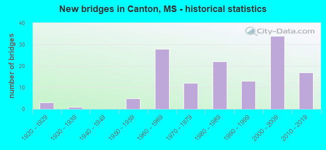
- New bridges - historical statistics
- 31920-1929
- 11930-1939
- 51950-1959
- 281960-1969
- 121970-1979
- 221980-1989
- 131990-1999
- 342000-2009
- 172010-2019

- Reconstructed bridges - Historical Statistics
- 11920-1929
- 01930-1939
- 01940-1949
- 01950-1959
- 01960-1969
- 01970-1979
- 21980-1989
- 01990-1999
- 12000-2009
- 72010-2019
- 32020-2022


- Bridge Condition - Deck
- 18.8%Very good
- 31.8%Good
- 25.9%Satisfactory
- 23.5%Fair

- Bridge Condition - Superstructure
- 43.5%Very good
- 24.7%Good
- 16.5%Satisfactory
- 15.3%Fair

- Bridge Condition - Substructure
- 50.6%Very good
- 29.4%Good
- 11.8%Satisfactory
- 4.7%Fair
- 2.4%Poor
- 1.2%Imminent failure

- Bridge Condition - Channel
- 27.2%Very good
- 41.3%Good
- 16.3%Satisfactory
- 14.1%Fair
- 1.1%Poor

- Bridge Condition - Culverts
- 55.2%Very good
- 27.6%Good
- 13.8%Satisfactory
- 3.4%Fair
Find on map >> Show street view
Structure Number: SA450000000007, Location: SEC 21 T 9N R 2E B (Lat: 32.615722, Lng: -90.089278), Route carried "on" structure: County highway 22, Year Built: 1988, Year Reconstructed: 2019, Status: Open, Structure Length: 0.94m (3.08ft), Average Daily Traffic: 240 (year 2015), Truck Traffic: 8%, Average Future Daily Traffic: 360 (year 2035), Design Load: H 15, Features Intersected: BEAR CREEK BRANCH, Facility Carried by Structure: OLD YAZOO CITY RD
Minimum Vertical Clearance: 30+ m (98+ ft), Kilometerpoint: 0.643, Lanes on structure: 2, Owner: County Highway Agency, Approaching Roadway Width: 6.1m (20.0ft), Material/Design: Concrete, Design/Construction: Channel Beam, Number Of Spans In Main Unit: 1, Length of Maximum Span: 9.4m (30.8ft), Curb or Sidewalk Widths: Left: 0.2m (0.7ft), Right: 0.2m (0.7ft), Curb-To-Curb Width: 8.1m (26.6ft), Out-to-Out Width: 8.5m (27.9ft)
Condition: Deck: Satisfactory, Superstructure: Satisfactory, Substructure: Good, Channel: Good, Operating Rating: 51.3 metric tons, Method Used To Determine Operating Rating: Load Factor (LF), Inventory Rating: 30.7 metric tons, Method Used To Determine Inventory Rating: Load Factor (LF), Structural Evaluation: Equal to present minimum criteria, Deck Geometry: Somewhat better than minimum adequacy, Waterway Adequacy: Equal to present desirable criteria, Approach Roadway Alignment: Equal to present desirable criteria, Length Of Structure Improvement: 1.74m (5.71ft), Designated Inspection Frequency: Every 24 months, Inspection Date: December 2020, Bridge Improvement Cost: $103,000, Roadway Improvement Cost: $10,000, Total Project Cost: $127,000 ( Estimate for 2016), Deck Structure Type: Concrete Precast Panels
Find on map >> Show street view
Structure Number: SA4500000000071, Location: SEC 23 T 9N R 2E B (Lat: 32.615194, Lng: -90.054889), Route carried "on" structure: County highway 7032, Year Built: 1976, Year Reconstructed: 2018, Status: Open, Structure Length: 1.16m (3.81ft), Average Daily Traffic: 250 (year 2015), Truck Traffic: 8%, Average Future Daily Traffic: 375 (year 2035), Design Load: H 15, Features Intersected: CREEK, Facility Carried by Structure: KING RANCH ROAD
Minimum Vertical Clearance: 30+ m (98+ ft), Kilometerpoint: 0.482, Lanes on structure: 2, Owner: City or Municipal Highway Agency, Approaching Roadway Width: 6.1m (20.0ft), Material/Design: Concrete, Design/Construction: Channel Beam, Number Of Spans In Main Unit: 2, Length of Maximum Span: 5.8m (19.0ft), Curb or Sidewalk Widths: Left: 0.2m (0.7ft), Right: 0.2m (0.7ft), Curb-To-Curb Width: 7.0m (23.0ft), Out-to-Out Width: 7.5m (24.6ft)
Condition: Deck: Fair, Superstructure: Fair, Substructure: Satisfactory, Channel: Satisfactory, Operating Rating: 47.1 metric tons, Method Used To Determine Operating Rating: Load Factor (LF), Inventory Rating: 28.5 metric tons, Method Used To Determine Inventory Rating: Load Factor (LF), Structural Evaluation: Somewhat better than minimum adequacy, Deck Geometry: Meets minimum limits, Waterway Adequacy: Equal to present minimum criteria, Approach Roadway Alignment: Equal to present desirable criteria, Length Of Structure Improvement: 1.74m (5.71ft), Designated Inspection Frequency: Every 24 months, Inspection Date: December 2020, Bridge Improvement Cost: $103,000, Roadway Improvement Cost: $10,000, Total Project Cost: $127,000 ( Estimate for 2016), Deck Structure Type: Concrete Precast Panels
Find on map >> Show street view
Structure Number: SA4500000000074, Location: SEC 22 T 9N R 3E (Lat: 32.603778, Lng: -89.971639), Route carried "on" structure: County highway 215, Year Built: 1998, Status: Open, Structure Length: 1.74m (5.71ft), Average Daily Traffic: 60 (year 2015), Average Future Daily Traffic: 90 (year 2035), Design Load: HS 20, Features Intersected: WALNUT CREEK TRIBUTARY, Facility Carried by Structure: KEARNEY ROAD
Minimum Vertical Clearance: 30+ m (98+ ft), Kilometerpoint: 0.160, Lanes on structure: 2, Owner: County Highway Agency, Approaching Roadway Width: 6.7m (22.0ft), Material/Design: Concrete, Design/Construction: Channel Beam, Number Of Spans In Main Unit: 3, Length of Maximum Span: 5.8m (19.0ft), Curb or Sidewalk Widths: Left: 0.2m (0.7ft), Right: 0.2m (0.7ft), Curb-To-Curb Width: 7.3m (24.0ft), Out-to-Out Width: 7.7m (25.3ft)
Condition: Deck: Good, Superstructure: Good, Substructure: Good, Channel: Satisfactory, Operating Rating: 70.0 metric tons, Method Used To Determine Operating Rating: Load Factor (LF) rating reported by rating factor (RF) method using MS18 loading, Inventory Rating: 41.8 metric tons, Method Used To Determine Inventory Rating: Load Factor (LF) rating reported by rating factor (RF) method using MS18 loading, Structural Evaluation: Better than present minimum criteria, Deck Geometry: Equal to present minimum criteria, Waterway Adequacy: Equal to present desirable criteria, Approach Roadway Alignment: Equal to present desirable criteria, Designated Inspection Frequency: Every 24 months, Inspection Date: March 2021, Deck Structure Type: Concrete Precast Panels
Find on map >> Show street view
Structure Number: SA4500000000077, Location: SEC 25 T 9N R 3E B (Lat: 32.597778, Lng: -89.936278), Route carried "on" structure: County highway 223, Year Built: 2001, Status: Open, Structure Length: 0.69m (2.26ft), Average Daily Traffic: 80 (year 2015), Average Future Daily Traffic: 120 (year 2035), Design Load: HS 20, Features Intersected: WALNUT CREEK, Facility Carried by Structure: SHARON ROAD
Minimum Vertical Clearance: 30+ m (98+ ft), Kilometerpoint: 5.310, Lanes on structure: 2, Owner: County Highway Agency, Approaching Roadway Width: 6.7m (22.0ft), Material/Design: Concrete, Design/Construction: Culvert, Number Of Spans In Main Unit: 2, Length of Maximum Span: 3.0m (9.8ft)
Condition: Channel: Very good, Culverts: Good, Operating Rating: 67.1 metric tons, Method Used To Determine Operating Rating: Load Factor (LF) rating reported by rating factor (RF) method using MS18 loading, Inventory Rating: 40.2 metric tons, Method Used To Determine Inventory Rating: Load Factor (LF) rating reported by rating factor (RF) method using MS18 loading, Structural Evaluation: Better than present minimum criteria, Waterway Adequacy: Equal to present desirable criteria, Approach Roadway Alignment: Equal to present desirable criteria, Designated Inspection Frequency: Every 24 months, Inspection Date: March 2021
Find on map >> Show street view
Structure Number: SA4500000000078, Location: SEC 27 T 9N R 3E (Lat: 32.600528, Lng: -89.973444), Route carried "on" structure: City street 214, Year Built: 1978, Status: Open, Structure Length: 1.74m (5.71ft), Average Daily Traffic: 110 (year 2014), Truck Traffic: 8%, Average Future Daily Traffic: 165 (year 2034), Design Load: H 15, Features Intersected: BCH OF WALNUT CREEK, Facility Carried by Structure: HART ROAD
Minimum Vertical Clearance: 30+ m (98+ ft), Kilometerpoint: 1.609, Lanes on structure: 2, Owner: City or Municipal Highway Agency, Approaching Roadway Width: 5.8m (19.0ft), Material/Design: Concrete, Design/Construction: Channel Beam, Number Of Spans In Main Unit: 3, Length of Maximum Span: 5.8m (19.0ft), Curb or Sidewalk Widths: Left: 0.2m (0.7ft), Right: 0.2m (0.7ft), Curb-To-Curb Width: 8.0m (26.2ft), Out-to-Out Width: 8.5m (27.9ft)
Condition: Deck: Satisfactory, Superstructure: Satisfactory, Substructure: Good, Channel: Good, Operating Rating: 50.9 metric tons, Method Used To Determine Operating Rating: Load Factor (LF), Inventory Rating: 30.7 metric tons, Method Used To Determine Inventory Rating: Load Factor (LF), Structural Evaluation: Equal to present minimum criteria, Deck Geometry: Somewhat better than minimum adequacy, Waterway Adequacy: Better than present minimum criteria, Approach Roadway Alignment: Equal to present desirable criteria, Length Of Structure Improvement: 2.83m (9.28ft), Designated Inspection Frequency: Every 24 months, Inspection Date: July 2020, Bridge Improvement Cost: $169,000, Roadway Improvement Cost: $17,000, Total Project Cost: $208,000 ( Estimate for 2015), Deck Structure Type: Concrete Precast Panels, Wearing Surface/Protective System: Wearing Surface: Bituminous
Find on map >> Show street view
Structure Number: SA450000000008, Location: SEC 27 T 9N R 3E (Lat: 32.590500, Lng: -89.973444), Route carried "on" structure: County highway 214, Year Built: 1976, Status: Open, Structure Length: 1.74m (5.71ft), Average Daily Traffic: 110 (year 2015), Truck Traffic: 8%, Average Future Daily Traffic: 165 (year 2035), Design Load: H 15, Features Intersected: WALNUT CREEK, Facility Carried by Structure: HART ROAD
Minimum Vertical Clearance: 30+ m (98+ ft), Kilometerpoint: 2.896, Lanes on structure: 2, Owner: County Highway Agency, Approaching Roadway Width: 5.8m (19.0ft), Material/Design: Concrete, Design/Construction: Channel Beam, Number Of Spans In Main Unit: 3, Length of Maximum Span: 5.8m (19.0ft), Curb or Sidewalk Widths: Left: 0.2m (0.7ft), Right: 0.2m (0.7ft), Curb-To-Curb Width: 8.0m (26.2ft), Out-to-Out Width: 8.5m (27.9ft)
Condition: Deck: Satisfactory, Superstructure: Satisfactory, Substructure: Good, Channel: Satisfactory, Operating Rating: 51.0 metric tons, Method Used To Determine Operating Rating: Load Factor (LF), Inventory Rating: 30.5 metric tons, Method Used To Determine Inventory Rating: Load Factor (LF), Structural Evaluation: Equal to present minimum criteria, Deck Geometry: Somewhat better than minimum adequacy, Waterway Adequacy: Somewhat better than minimum adequacy, Approach Roadway Alignment: Equal to present desirable criteria, Length Of Structure Improvement: 2.83m (9.28ft), Designated Inspection Frequency: Every 24 months, Inspection Date: July 2020, Bridge Improvement Cost: $169,000, Roadway Improvement Cost: $17,000, Total Project Cost: $208,000 ( Estimate for 2016), Deck Structure Type: Concrete Precast Panels, Wearing Surface/Protective System: Wearing Surface: Bituminous
Find on map >> Show street view
Structure Number: SA4500000000081, Location: SEC 34 T 9N R 3E (Lat: 32.582972, Lng: -89.973500), Route carried "on" structure: County highway 214, Year Built: 1975, Year Reconstructed: 2020, Status: Open, Structure Length: 1.16m (3.81ft), Average Daily Traffic: 110 (year 2015), Truck Traffic: 8%, Average Future Daily Traffic: 165 (year 2034), Design Load: H 15, Features Intersected: BCH OF WALNUT CREEK, Facility Carried by Structure: HART ROAD
Minimum Vertical Clearance: 30+ m (98+ ft), Kilometerpoint: 3.701, Lanes on structure: 2, Owner: County Highway Agency, Approaching Roadway Width: 5.8m (19.0ft), Material/Design: Concrete, Design/Construction: Channel Beam, Number Of Spans In Main Unit: 2, Length of Maximum Span: 5.8m (19.0ft), Curb or Sidewalk Widths: Left: 0.2m (0.7ft), Right: 0.2m (0.7ft), Curb-To-Curb Width: 8.0m (26.2ft), Out-to-Out Width: 8.5m (27.9ft)
Condition: Deck: Fair, Superstructure: Fair, Substructure: Good, Channel: Good, Operating Rating: 57.8 metric tons, Method Used To Determine Operating Rating: Load Factor (LF), Inventory Rating: 34.6 metric tons, Method Used To Determine Inventory Rating: Load Factor (LF), Structural Evaluation: Somewhat better than minimum adequacy, Deck Geometry: Somewhat better than minimum adequacy, Waterway Adequacy: Equal to present minimum criteria, Approach Roadway Alignment: Equal to present desirable criteria, Length Of Structure Improvement: 2.10m (6.89ft), Designated Inspection Frequency: Every 24 months, Inspection Date: September 2019, Bridge Improvement Cost: $126,000, Roadway Improvement Cost: $13,000, Total Project Cost: $156,000 ( Estimate for 2015), Deck Structure Type: Concrete Precast Panels, Wearing Surface/Protective System: Wearing Surface: Bituminous
Find on map >> Show street view
Structure Number: SA4500000000082, Location: SEC 35 T 9N R 3E B (Lat: 32.574861, Lng: -89.963306), Route carried "on" structure: County highway 234, Year Built: 1984, Status: Open, Structure Length: 1.74m (5.71ft), Average Daily Traffic: 100 (year 2015), Average Future Daily Traffic: 150 (year 2035), Design Load: H 15, Features Intersected: BCH OF WALNUT CREEK, Facility Carried by Structure: RANKIN ROAD
Minimum Vertical Clearance: 30+ m (98+ ft), Kilometerpoint: 3.379, Lanes on structure: 2, Owner: County Highway Agency, Approaching Roadway Width: 5.6m (18.4ft), Material/Design: Concrete, Design/Construction: Channel Beam, Number Of Spans In Main Unit: 3, Length of Maximum Span: 5.8m (19.0ft), Curb-To-Curb Width: 8.5m (27.9ft), Out-to-Out Width: 9.3m (30.5ft)
Condition: Deck: Satisfactory, Superstructure: Satisfactory, Substructure: Satisfactory, Channel: Good, Operating Rating: 57.5 metric tons, Method Used To Determine Operating Rating: Load Factor (LF), Inventory Rating: 34.3 metric tons, Method Used To Determine Inventory Rating: Load Factor (LF), Structural Evaluation: Equal to present minimum criteria, Deck Geometry: Better than present minimum criteria, Waterway Adequacy: Equal to present desirable criteria, Approach Roadway Alignment: Equal to present desirable criteria, Designated Inspection Frequency: Every 24 months, Inspection Date: October 2020, Deck Structure Type: Concrete Precast Panels, Wearing Surface/Protective System: Wearing Surface: Monolithic Concrete
Find on map >> Show street view
Structure Number: SA4500000000083, Location: SEC 36 T 9N R 3E B (Lat: 32.574917, Lng: -89.939611), Route carried "on" structure: County highway 234, Year Built: 1984, Year Reconstructed: 2020, Status: Posted for load, Structure Length: 2.10m (6.89ft), Average Daily Traffic: 100 (year 2015), Average Future Daily Traffic: 150 (year 2033), Design Load: H 15, Features Intersected: BCH OF WALNUT CREEK, Facility Carried by Structure: RANKIN ROAD
Minimum Vertical Clearance: 30+ m (98+ ft), Kilometerpoint: 5.793, Lanes on structure: 2, Owner: County Highway Agency, Approaching Roadway Width: 5.8m (19.0ft), Material/Design: Concrete, Design/Construction: Channel Beam, Number Of Spans In Main Unit: 3, Length of Maximum Span: 9.4m (30.8ft), Curb-To-Curb Width: 8.5m (27.9ft), Out-to-Out Width: 9.3m (30.5ft)
Condition: Deck: Satisfactory, Superstructure: Satisfactory, Substructure: Good, Channel: Good, Operating Rating: 50.0 metric tons, Method Used To Determine Operating Rating: Load Factor (LF), Inventory Rating: 30.0 metric tons, Method Used To Determine Inventory Rating: Load Factor (LF), Structural Evaluation: Equal to present minimum criteria, Deck Geometry: Better than present minimum criteria, Waterway Adequacy: Equal to present desirable criteria, Approach Roadway Alignment: Equal to present desirable criteria, Designated Inspection Frequency: Every 24 months, Inspection Date: October 2020, Deck Structure Type: Concrete Precast Panels, Wearing Surface/Protective System: Wearing Surface: Monolithic Concrete
Find on map >> Show street view
Structure Number: SA4500000000086, Location: SEC 6 T 9N R 4E (Lat: 32.647000, Lng: -89.935639), Route carried "on" structure: County highway 232, Year Built: 1982, Year Reconstructed: 2018, Status: Open, Structure Length: 1.16m (3.81ft), Average Daily Traffic: 120 (year 2015), Truck Traffic: 8%, Average Future Daily Traffic: 180 (year 2035), Design Load: H 15, Features Intersected: BCH OF TILDA BOGUE, Facility Carried by Structure: SHARON ROAD
Minimum Vertical Clearance: 30+ m (98+ ft), Kilometerpoint: 1.931, Lanes on structure: 2, Owner: County Highway Agency, Approaching Roadway Width: 5.5m (18.0ft), Material/Design: Concrete, Design/Construction: Channel Beam, Number Of Spans In Main Unit: 2, Length of Maximum Span: 5.8m (19.0ft), Curb or Sidewalk Widths: Left: 0.2m (0.7ft), Right: 0.2m (0.7ft), Curb-To-Curb Width: 8.1m (26.6ft), Out-to-Out Width: 8.5m (27.9ft)
Condition: Deck: Fair, Superstructure: Fair, Substructure: Satisfactory, Channel: Satisfactory, Operating Rating: 55.2 metric tons, Method Used To Determine Operating Rating: Load Factor (LF), Inventory Rating: 33.0 metric tons, Method Used To Determine Inventory Rating: Load Factor (LF), Structural Evaluation: Somewhat better than minimum adequacy, Deck Geometry: Somewhat better than minimum adequacy, Waterway Adequacy: Somewhat better than minimum adequacy, Approach Roadway Alignment: Equal to present desirable criteria, Length Of Structure Improvement: 2.10m (6.89ft), Designated Inspection Frequency: Every 24 months, Inspection Date: December 2020, Bridge Improvement Cost: $126,000, Roadway Improvement Cost: $13,000, Total Project Cost: $156,000 ( Estimate for 2016), Deck Structure Type: Concrete Precast Panels
Find on map >> Show street view
Structure Number: SA4500000000088, Location: SEC 18 T 9N R 4E B (Lat: 32.618444, Lng: -89.920333), Route carried "on" structure: County highway 212, Year Built: 1979, Year Reconstructed: 2018, Status: Open, Structure Length: 1.74m (5.71ft), Average Daily Traffic: 180 (year 2015), Truck Traffic: 8%, Average Future Daily Traffic: 290 (year 2035), Design Load: H 15, Features Intersected: BCH TILDA BOGUE, Facility Carried by Structure: ROBINSON ROAD
Minimum Vertical Clearance: 30+ m (98+ ft), Kilometerpoint: 3.540, Lanes on structure: 2, Owner: County Highway Agency, Approaching Roadway Width: 5.5m (18.0ft), Material/Design: Concrete, Design/Construction: Channel Beam, Number Of Spans In Main Unit: 3, Length of Maximum Span: 5.8m (19.0ft), Curb or Sidewalk Widths: Left: 0.2m (0.7ft), Right: 0.2m (0.7ft), Curb-To-Curb Width: 8.1m (26.6ft), Out-to-Out Width: 8.5m (27.9ft)
Condition: Deck: Good, Superstructure: Good, Substructure: Satisfactory, Channel: Good, Operating Rating: 55.2 metric tons, Method Used To Determine Operating Rating: Load Factor (LF), Inventory Rating: 33.0 metric tons, Method Used To Determine Inventory Rating: Load Factor (LF), Structural Evaluation: Equal to present minimum criteria, Deck Geometry: Somewhat better than minimum adequacy, Waterway Adequacy: Equal to present minimum criteria, Approach Roadway Alignment: Equal to present desirable criteria, Length Of Structure Improvement: 2.32m (7.61ft), Designated Inspection Frequency: Every 24 months, Inspection Date: December 2020, Bridge Improvement Cost: $138,000, Roadway Improvement Cost: $14,000, Total Project Cost: $170,000 ( Estimate for 2016), Deck Structure Type: Concrete Precast Panels
Find on map >> Show street view
Structure Number: SA4500000000089, Location: SEC 18 T 9N R 4E B (Lat: 32.617889, Lng: -89.933278), Route carried "on" structure: County highway 212, Year Built: 1979, Year Reconstructed: 2017, Status: Open, Structure Length: 1.74m (5.71ft), Average Daily Traffic: 180 (year 2015), Truck Traffic: 8%, Average Future Daily Traffic: 270 (year 2035), Design Load: H 15, Features Intersected: TILDA BOGUE, Facility Carried by Structure: ROBINSON ROAD
Minimum Vertical Clearance: 30+ m (98+ ft), Kilometerpoint: 4.667, Lanes on structure: 2, Owner: County Highway Agency, Approaching Roadway Width: 6.1m (20.0ft), Material/Design: Concrete, Design/Construction: Channel Beam, Number Of Spans In Main Unit: 3, Length of Maximum Span: 5.8m (19.0ft), Curb or Sidewalk Widths: Left: 0.2m (0.7ft), Right: 0.2m (0.7ft), Curb-To-Curb Width: 8.1m (26.6ft), Out-to-Out Width: 8.5m (27.9ft)
Condition: Deck: Good, Superstructure: Good, Substructure: Satisfactory, Channel: Satisfactory, Operating Rating: 55.2 metric tons, Method Used To Determine Operating Rating: Load Factor (LF), Inventory Rating: 33.0 metric tons, Method Used To Determine Inventory Rating: Load Factor (LF), Structural Evaluation: Equal to present minimum criteria, Deck Geometry: Somewhat better than minimum adequacy, Waterway Adequacy: Equal to present minimum criteria, Approach Roadway Alignment: Equal to present desirable criteria, Length Of Structure Improvement: 2.32m (7.61ft), Designated Inspection Frequency: Every 24 months, Inspection Date: December 2020, Bridge Improvement Cost: $138,000, Roadway Improvement Cost: $14,000, Total Project Cost: $170,000 ( Estimate for 2016), Deck Structure Type: Concrete Precast Panels, Wearing Surface/Protective System: Wearing Surface: Bituminous
Find on map >> Show street view
Structure Number: SA450000000009, Location: SEC 18 T 9N R 4E B (Lat: 32.619556, Lng: -89.936222), Route carried "on" structure: County highway 223, Year Built: 1982, Year Reconstructed: 2019, Status: Open, Structure Length: 2.32m (7.61ft), Average Daily Traffic: 120 (year 2015), Truck Traffic: 8%, Average Future Daily Traffic: 180 (year 2035), Design Load: H 15, Features Intersected: TILDA BOGUE, Facility Carried by Structure: SHARON ROAD
Minimum Vertical Clearance: 30+ m (98+ ft), Kilometerpoint: 7.402, Lanes on structure: 2, Owner: County Highway Agency, Approaching Roadway Width: 6.1m (20.0ft), Material/Design: Concrete, Design/Construction: Channel Beam, Number Of Spans In Main Unit: 4, Length of Maximum Span: 5.8m (19.0ft), Curb or Sidewalk Widths: Left: 0.2m (0.7ft), Right: 0.2m (0.7ft), Curb-To-Curb Width: 8.1m (26.6ft), Out-to-Out Width: 8.5m (27.9ft)
Condition: Deck: Good, Superstructure: Good, Substructure: Very good, Channel: Good, Operating Rating: 50.4 metric tons, Method Used To Determine Operating Rating: Load Factor (LF), Inventory Rating: 30.2 metric tons, Method Used To Determine Inventory Rating: Load Factor (LF), Structural Evaluation: Better than present minimum criteria, Deck Geometry: Somewhat better than minimum adequacy, Waterway Adequacy: Better than present minimum criteria, Approach Roadway Alignment: Equal to present desirable criteria, Length Of Structure Improvement: 2.83m (9.28ft), Designated Inspection Frequency: Every 24 months, Inspection Date: April 2020, Bridge Improvement Cost: $169,000, Roadway Improvement Cost: $17,000, Total Project Cost: $208,000 ( Estimate for 2016), Deck Structure Type: Concrete Precast Panels, Wearing Surface/Protective System: Wearing Surface: Monolithic Concrete
Find on map >> Show street view
Structure Number: SA4500000000091, Location: SEC 18 T 9N R 4E B (Lat: 32.623417, Lng: -89.936306), Route carried "on" structure: County highway 223, Year Built: 1980, Year Reconstructed: 2020, Status: Open, Structure Length: 2.90m (9.51ft), Average Daily Traffic: 120 (year 2015), Truck Traffic: 8%, Average Future Daily Traffic: 180 (year 2035), Design Load: H 15, Features Intersected: BCH OF TILDA BOGUE, Facility Carried by Structure: SHARON ROAD
Minimum Vertical Clearance: 30+ m (98+ ft), Kilometerpoint: 7.724, Lanes on structure: 2, Owner: County Highway Agency, Approaching Roadway Width: 6.4m (21.0ft), Material/Design: Concrete, Design/Construction: Channel Beam, Number Of Spans In Main Unit: 5, Length of Maximum Span: 5.8m (19.0ft), Curb or Sidewalk Widths: Left: 0.2m (0.7ft), Right: 0.2m (0.7ft), Curb-To-Curb Width: 8.1m (26.6ft), Out-to-Out Width: 8.5m (27.9ft)
Condition: Deck: Satisfactory, Superstructure: Satisfactory, Substructure: Very good, Channel: Good, Operating Rating: 57.8 metric tons, Method Used To Determine Operating Rating: Load Factor (LF), Inventory Rating: 34.6 metric tons, Method Used To Determine Inventory Rating: Load Factor (LF), Structural Evaluation: Equal to present minimum criteria, Deck Geometry: Somewhat better than minimum adequacy, Waterway Adequacy: Better than present minimum criteria, Approach Roadway Alignment: Equal to present desirable criteria, Length Of Structure Improvement: 3.66m (12.01ft), Designated Inspection Frequency: Every 24 months, Inspection Date: September 2021, Bridge Improvement Cost: $218,000, Roadway Improvement Cost: $22,000, Total Project Cost: $269,000 ( Estimate for 2016), Deck Structure Type: Concrete Precast Panels, Wearing Surface/Protective System: Wearing Surface: Monolithic Concrete
Find on map >> Show street view
Structure Number: SA4500000000092, Location: SEC 31 T 9N R 4E (Lat: 32.571361, Lng: -89.930639), Route carried "on" structure: County highway 232, Year Built: 2001, Status: Open, Structure Length: 1.74m (5.71ft), Average Daily Traffic: 100 (year 2016), Average Future Daily Traffic: 150 (year 2036), Design Load: HS 20, Features Intersected: BCH OF WALNUT CREEK, Facility Carried by Structure: PINE GROVE ROAD
Minimum Vertical Clearance: 30+ m (98+ ft), Kilometerpoint: 0.643, Lanes on structure: 2, Owner: County Highway Agency, Approaching Roadway Width: 6.1m (20.0ft), Material/Design: Concrete, Design/Construction: Channel Beam, Number Of Spans In Main Unit: 3, Length of Maximum Span: 5.8m (19.0ft), Curb or Sidewalk Widths: Left: 0.2m (0.7ft), Right: 0.2m (0.7ft), Curb-To-Curb Width: 7.3m (24.0ft), Out-to-Out Width: 7.7m (25.3ft)
Condition: Deck: Good, Superstructure: Good, Substructure: Good, Channel: Good, Operating Rating: 70.0 metric tons, Method Used To Determine Operating Rating: Load Factor (LF) rating reported by rating factor (RF) method using MS18 loading, Inventory Rating: 41.8 metric tons, Method Used To Determine Inventory Rating: Load Factor (LF) rating reported by rating factor (RF) method using MS18 loading, Structural Evaluation: Better than present minimum criteria, Deck Geometry: Equal to present minimum criteria, Waterway Adequacy: Equal to present desirable criteria, Approach Roadway Alignment: Equal to present desirable criteria, Designated Inspection Frequency: Every 24 months, Inspection Date: July 2020, Deck Structure Type: Concrete Precast Panels, Wearing Surface/Protective System: Wearing Surface: Monolithic Concrete
Find on map >> Show street view
Structure Number: SA4500000000107, Location: SEC 20 T10N R 3E B (Lat: 32.691111, Lng: -90.003556), Route carried "on" structure: County highway 366, Year Built: 1993, Status: Open, Structure Length: 1.74m (5.71ft), Average Daily Traffic: 100 (year 2016), Average Future Daily Traffic: 150 (year 2036), Design Load: H 15, Features Intersected: CREEK, Facility Carried by Structure: DAVIS ROAD
Minimum Vertical Clearance: 30+ m (98+ ft), Kilometerpoint: 5.310, Lanes on structure: 2, Owner: County Highway Agency, Approaching Roadway Width: 6.7m (22.0ft), Material/Design: Concrete, Design/Construction: Channel Beam, Number Of Spans In Main Unit: 3, Length of Maximum Span: 5.8m (19.0ft), Curb or Sidewalk Widths: Left: 0.2m (0.7ft), Right: 0.2m (0.7ft), Curb-To-Curb Width: 8.1m (26.6ft), Out-to-Out Width: 8.5m (27.9ft)
Condition: Deck: Satisfactory, Superstructure: Satisfactory, Substructure: Fair, Channel: Satisfactory, Operating Rating: 58.3 metric tons, Method Used To Determine Operating Rating: Load Factor (LF) rating reported by rating factor (RF) method using MS18 loading, Inventory Rating: 35.0 metric tons, Method Used To Determine Inventory Rating: Load Factor (LF) rating reported by rating factor (RF) method using MS18 loading, Structural Evaluation: Somewhat better than minimum adequacy, Deck Geometry: Equal to present minimum criteria, Waterway Adequacy: Equal to present desirable criteria, Approach Roadway Alignment: Equal to present minimum criteria, Length Of Structure Improvement: 1.74m (5.71ft), Designated Inspection Frequency: Every 24 months, Inspection Date: March 2021, Bridge Improvement Cost: $103,000, Roadway Improvement Cost: $10,000, Total Project Cost: $127,000 ( Estimate for 2017), Deck Structure Type: Concrete Precast Panels
Find on map >> Show street view
Structure Number: SA4500000000109, Location: SEC 32 T10N R 3E (Lat: 32.674194, Lng: -90.012028), Route carried "on" structure: County highway 98, Year Built: 1999, Status: Open, Structure Length: 3.26m (10.70ft), Average Daily Traffic: 80 (year 2016), Average Future Daily Traffic: 120 (year 2036), Design Load: HS 20, Features Intersected: TILDA BOGUE TRIBUTARY, Facility Carried by Structure: PISGAH BOTTOM RD
Minimum Vertical Clearance: 30+ m (98+ ft), Kilometerpoint: 1.126, Lanes on structure: 2, Owner: County Highway Agency, Approaching Roadway Width: 7.3m (24.0ft), Skew: 3 degrees, Material/Design: Concrete, Design/Construction: Channel Beam, Number Of Spans In Main Unit: 5, Length of Maximum Span: 9.4m (30.8ft), Curb or Sidewalk Widths: Left: 0.2m (0.7ft), Right: 0.2m (0.7ft), Curb-To-Curb Width: 8.1m (26.6ft), Out-to-Out Width: 8.5m (27.9ft)
Condition: Deck: Good, Superstructure: Good, Substructure: Good, Channel: Good, Operating Rating: 74.8 metric tons, Method Used To Determine Operating Rating: Load Factor (LF) rating reported by rating factor (RF) method using MS18 loading, Inventory Rating: 45.0 metric tons, Method Used To Determine Inventory Rating: Load Factor (LF) rating reported by rating factor (RF) method using MS18 loading, Structural Evaluation: Better than present minimum criteria, Deck Geometry: Equal to present minimum criteria, Waterway Adequacy: Equal to present desirable criteria, Approach Roadway Alignment: Equal to present desirable criteria, Designated Inspection Frequency: Every 24 months, Inspection Date: June 2020, Deck Structure Type: Concrete Precast Panels, Wearing Surface/Protective System: Wearing Surface: Monolithic Concrete
Find on map >> Show street view
Structure Number: SA4500000000148, Location: SEC 1 T 8N R 2E (Lat: 32.570556, Lng: -90.046389), Route carried "on" structure: City street 6988, Year Built: 1999, Status: Open, Structure Length: 1.16m (3.81ft), Average Daily Traffic: 1,100 (year 2016), Truck Traffic: 8%, Average Future Daily Traffic: 1,650 (year 2036), Design Load: H 15, Features Intersected: BEAR CREEK, Facility Carried by Structure: N OLD CANTON RD B
Minimum Vertical Clearance: 30+ m (98+ ft), Kilometerpoint: 1.100, Lanes on structure: 2, Owner: County Highway Agency, Approaching Roadway Width: 6.7m (22.0ft), Material/Design: Concrete, Design/Construction: Channel Beam, Number Of Spans In Main Unit: 2, Length of Maximum Span: 5.8m (19.0ft), Curb or Sidewalk Widths: Left: 0.2m (0.7ft), Right: 0.2m (0.7ft), Curb-To-Curb Width: 7.1m (23.3ft), Out-to-Out Width: 7.5m (24.6ft)
Condition: Deck: Satisfactory, Superstructure: Good, Substructure: Satisfactory, Channel: Good, Operating Rating: 59.0 metric tons, Method Used To Determine Operating Rating: Load Factor (LF) rating reported by rating factor (RF) method using MS18 loading, Inventory Rating: 35.3 metric tons, Method Used To Determine Inventory Rating: Load Factor (LF) rating reported by rating factor (RF) method using MS18 loading, Structural Evaluation: Equal to present minimum criteria, Deck Geometry: High priority of corrective action, Waterway Adequacy: Equal to present desirable criteria, Approach Roadway Alignment: Equal to present desirable criteria, Length Of Structure Improvement: 1.74m (5.71ft), Designated Inspection Frequency: Every 24 months, Inspection Date: July 2020, Bridge Improvement Cost: $103,000, Roadway Improvement Cost: $10,000, Total Project Cost: $127,000 ( Estimate for 2017), Deck Structure Type: Concrete Precast Panels, Wearing Surface/Protective System: Wearing Surface: Monolithic Concrete
Find on map >> Show street view
Structure Number: SA4500000000149, Location: SEC 5 T 8N R 3E (Lat: 32.560472, Lng: -90.021861), Route carried "on" structure: County highway 235, Year Built: 2009, Status: Open, Structure Length: 2.89m (9.48ft), Average Daily Traffic: 30 (year 2016), Average Future Daily Traffic: 45 (year 2036), Design Load: HS 20, Features Intersected: LITTLE BEAR CREEK, Facility Carried by Structure: ENDRIS RD
Minimum Vertical Clearance: 30+ m (98+ ft), Kilometerpoint: 1.350, Lanes on structure: 2, Owner: County Highway Agency, Approaching Roadway Width: 7.3m (24.0ft), Material/Design: Concrete, Design/Construction: Channel Beam, Number Of Spans In Main Unit: 5, Length of Maximum Span: 5.8m (19.0ft), Curb or Sidewalk Widths: Left: 0.2m (0.7ft), Right: 0.2m (0.7ft), Curb-To-Curb Width: 8.1m (26.6ft), Out-to-Out Width: 8.5m (27.9ft)
Condition: Deck: Satisfactory, Superstructure: Satisfactory, Substructure: Good, Channel: Good, Operating Rating: 89.4 metric tons, Method Used To Determine Operating Rating: Load Factor (LF) rating reported by rating factor (RF) method using MS18 loading, Inventory Rating: 53.5 metric tons, Method Used To Determine Inventory Rating: Load Factor (LF) rating reported by rating factor (RF) method using MS18 loading, Structural Evaluation: Equal to present minimum criteria, Deck Geometry: Equal to present minimum criteria, Waterway Adequacy: Equal to present desirable criteria, Approach Roadway Alignment: Equal to present desirable criteria, Designated Inspection Frequency: Every 24 months, Inspection Date: July 2020, Deck Structure Type: Concrete Precast Panels, Wearing Surface/Protective System: Wearing Surface: Monolithic Concrete
Find on map >> Show street view
Structure Number: SA4500000000152, Location: SEC 28 T 8N R 2E (Lat: 32.510556, Lng: -90.100694), Route carried "on" structure: County highway 7079, Year Built: 1995, Status: Open, Structure Length: 1.16m (3.81ft), Average Daily Traffic: 300 (year 2016), Truck Traffic: 8%, Average Future Daily Traffic: 450 (year 2036), Design Load: HS 20, Features Intersected: DRAINAGE DITCH, Facility Carried by Structure: INDUSTRIAL DR.
Minimum Vertical Clearance: 30+ m (98+ ft), Kilometerpoint: 0.800, Lanes on structure: 2, Owner: County Highway Agency, Approaching Roadway Width: 8.5m (27.9ft), Material/Design: Concrete, Design/Construction: Channel Beam, Number Of Spans In Main Unit: 2, Length of Maximum Span: 5.8m (19.0ft), Curb or Sidewalk Widths: Left: 0.2m (0.7ft), Right: 0.2m (0.7ft), Curb-To-Curb Width: 9.1m (29.9ft), Out-to-Out Width: 9.5m (31.2ft)
Condition: Deck: Satisfactory, Superstructure: Satisfactory, Substructure: Good, Channel: Satisfactory, Operating Rating: 70.0 metric tons, Method Used To Determine Operating Rating: Load Factor (LF) rating reported by rating factor (RF) method using MS18 loading, Inventory Rating: 41.8 metric tons, Method Used To Determine Inventory Rating: Load Factor (LF) rating reported by rating factor (RF) method using MS18 loading, Structural Evaluation: Equal to present minimum criteria, Deck Geometry: Equal to present minimum criteria, Waterway Adequacy: Better than present minimum criteria, Approach Roadway Alignment: Equal to present desirable criteria, Designated Inspection Frequency: Every 24 months, Inspection Date: July 2020, Deck Structure Type: Concrete Precast Panels, Wearing Surface/Protective System: Wearing Surface: Monolithic Concrete
Find on map >> Show street view
Structure Number: SA4500000000154, Location: SEC 19 T 9N R 3E (Lat: 32.617861, Lng: -90.024667), Route carried "on" structure: City street 813, Year Built: 1985, Status: Open, Structure Length: 1.89m (6.20ft), Average Daily Traffic: 300 (year 2016), Truck Traffic: 20%, Average Future Daily Traffic: 450 (year 2036), Design Load: HS 20, Features Intersected: CANAL, Facility Carried by Structure: MILLER ST
Minimum Vertical Clearance: 30+ m (98+ ft), Kilometerpoint: 0.100, Lanes on structure: 2, Owner: City or Municipal Highway Agency, Approaching Roadway Width: 9.1m (29.9ft), Material/Design: Concrete, Design/Construction: Channel Beam, Number Of Spans In Main Unit: 2, Length of Maximum Span: 9.4m (30.8ft), Curb or Sidewalk Widths: Left: 0.5m (1.6ft), Right: 0.5m (1.6ft), Curb-To-Curb Width: 9.3m (30.5ft), Out-to-Out Width: 10.3m (33.8ft)
Condition: Deck: Satisfactory, Superstructure: Satisfactory, Substructure: Good, Channel: Good, Operating Rating: 59.3 metric tons, Method Used To Determine Operating Rating: Load Factor (LF) rating reported by rating factor (RF) method using MS18 loading, Inventory Rating: 35.6 metric tons, Method Used To Determine Inventory Rating: Load Factor (LF) rating reported by rating factor (RF) method using MS18 loading, Structural Evaluation: Equal to present minimum criteria, Deck Geometry: Equal to present minimum criteria, Waterway Adequacy: Equal to present desirable criteria, Approach Roadway Alignment: Equal to present desirable criteria, Designated Inspection Frequency: Every 24 months, Inspection Date: July 2020, Deck Structure Type: Concrete Precast Panels, Wearing Surface/Protective System: Wearing Surface: Monolithic Concrete
Find on map >> Show street view
Structure Number: SA4500000000156, Location: SEC 20 T 9N R 3E (Lat: 32.617278, Lng: -90.010556), Route carried "on" structure: City street 811, Year Built: 1980, Year Reconstructed: 2017, Status: Open, Structure Length: 1.74m (5.71ft), Average Daily Traffic: 400 (year 2015), Truck Traffic: 20%, Average Future Daily Traffic: 600 (year 2035), Design Load: H 15, Features Intersected: CANAL, Facility Carried by Structure: COVINGTON DR.
Minimum Vertical Clearance: 30+ m (98+ ft), Kilometerpoint: 1.600, Lanes on structure: 2, Owner: City or Municipal Highway Agency, Approaching Roadway Width: 7.3m (24.0ft), Skew: 3 degrees, Material/Design: Concrete, Design/Construction: Channel Beam, Number Of Spans In Main Unit: 3, Length of Maximum Span: 5.8m (19.0ft), Curb or Sidewalk Widths: Left: 0.2m (0.7ft), Right: 0.2m (0.7ft), Curb-To-Curb Width: 8.0m (26.2ft), Out-to-Out Width: 8.5m (27.9ft)
Condition: Deck: Satisfactory, Superstructure: Satisfactory, Substructure: Satisfactory, Channel: Good, Operating Rating: 57.8 metric tons, Method Used To Determine Operating Rating: Load Factor (LF), Inventory Rating: 34.7 metric tons, Method Used To Determine Inventory Rating: Load Factor (LF), Structural Evaluation: Equal to present minimum criteria, Deck Geometry: Somewhat better than minimum adequacy, Waterway Adequacy: Better than present minimum criteria, Approach Roadway Alignment: Equal to present desirable criteria, Length Of Structure Improvement: 2.83m (9.28ft), Designated Inspection Frequency: Every 24 months, Inspection Date: December 2020, Bridge Improvement Cost: $169,000, Roadway Improvement Cost: $17,000, Total Project Cost: $208,000 ( Estimate for 2016), Deck Structure Type: Concrete Precast Panels
Find on map >> Show street view
Structure Number: SA4500000000157, Location: SEC 13 T 9N R 2E (Lat: 32.621667, Lng: -90.044167), Route carried "on" structure: City street 885, Year Built: 1980, Status: Open, Structure Length: 2.19m (7.19ft), Average Daily Traffic: 400 (year 2016), Truck Traffic: 8%, Average Future Daily Traffic: 600 (year 2036), Design Load: HS 20, Features Intersected: CANAL, Facility Carried by Structure: MLK JR SOUTH
Minimum Vertical Clearance: 30+ m (98+ ft), Kilometerpoint: 0.794, Lanes on structure: 2, Owner: City or Municipal Highway Agency, Approaching Roadway Width: 9.1m (29.9ft), Skew: 4 degrees, Material/Design: Prestressed concrete, Design/Construction: Stringer/Multi-beam, Number Of Spans In Main Unit: 1, Length of Maximum Span: 21.9m (71.9ft), Curb or Sidewalk Widths: Left: 0.3m (1.0ft), Right: 1.8m (5.9ft), Curb-To-Curb Width: 9.1m (29.9ft), Out-to-Out Width: 11.3m (37.1ft)
Condition: Deck: Satisfactory, Superstructure: Good, Substructure: Good, Channel: Very good, Operating Rating: 50.0 metric tons, Method Used To Determine Operating Rating: Field evaluation and documented engineering judgment, Inventory Rating: 50.0 metric tons, Method Used To Determine Inventory Rating: Field evaluation and documented engineering judgment, Structural Evaluation: Better than present minimum criteria, Deck Geometry: Equal to present minimum criteria, Waterway Adequacy: Equal to present desirable criteria, Approach Roadway Alignment: Equal to present desirable criteria, Designated Inspection Frequency: Every 24 months, Inspection Date: July 2020, Deck Structure Type: Concrete Cast-file-Place, Wearing Surface/Protective System: Wearing Surface: Monolithic Concrete
Find on map >> Show street view
Structure Number: SA4500000000187, Location: SEC 26 T 9N R 2E (Lat: 32.603472, Lng: -90.071111), Route carried "on" structure: City street 9999, Year Built: 1993, Status: Open, Structure Length: 1.74m (5.71ft), Average Daily Traffic: 800 (year 2016), Truck Traffic: 15%, Average Future Daily Traffic: 1,200 (year 2036), Design Load: HS 20, Features Intersected: DITCH, Facility Carried by Structure: FEATHER LN
Minimum Vertical Clearance: 30+ m (98+ ft), Kilometerpoint: 0.025, Lanes on structure: 2, Owner: City or Municipal Highway Agency, Approaching Roadway Width: 7.3m (24.0ft), Material/Design: Concrete, Design/Construction: Channel Beam, Number Of Spans In Main Unit: 3, Length of Maximum Span: 5.8m (19.0ft), Curb or Sidewalk Widths: Left: 0.2m (0.7ft), Right: 0.2m (0.7ft), Curb-To-Curb Width: 8.1m (26.6ft), Out-to-Out Width: 8.5m (27.9ft)
Condition: Deck: Good, Superstructure: Good, Substructure: Very good, Channel: Very good, Operating Rating: 58.3 metric tons, Method Used To Determine Operating Rating: Load Factor (LF) rating reported by rating factor (RF) method using MS18 loading, Inventory Rating: 35.0 metric tons, Method Used To Determine Inventory Rating: Load Factor (LF) rating reported by rating factor (RF) method using MS18 loading, Structural Evaluation: Better than present minimum criteria, Deck Geometry: Somewhat better than minimum adequacy, Waterway Adequacy: Better than present minimum criteria, Approach Roadway Alignment: Equal to present desirable criteria, Designated Inspection Frequency: Every 24 months, Inspection Date: July 2020, Deck Structure Type: Concrete Precast Panels, Wearing Surface/Protective System: Wearing Surface: Monolithic Concrete
Find on map >> Show street view
Structure Number: SA4500000000194, Location: SEC 24 T 9N R 3E (Lat: 32.604639, Lng: -89.951611), Route carried "on" structure: County highway 222, Year Built: 2012, Status: Open, Structure Length: 0.92m (3.02ft), Average Daily Traffic: 60 (year 2015), Truck Traffic: 8%, Average Future Daily Traffic: 90 (year 2035), Design Load: HS 20, Features Intersected: BRANCH WALNUT CREEK, Facility Carried by Structure: MOSS ROAD
Minimum Vertical Clearance: 30+ m (98+ ft), Kilometerpoint: 1.609, Lanes on structure: 2, Owner: County Highway Agency, Approaching Roadway Width: 6.1m (20.0ft), Material/Design: Concrete, Design/Construction: Culvert, Number Of Spans In Main Unit: 2, Length of Maximum Span: 4.3m (14.1ft)
Condition: Channel: Very good, Culverts: Good, Operating Rating: 54.1 metric tons, Method Used To Determine Operating Rating: Load Factor (LF) rating reported by rating factor (RF) method using MS18 loading, Inventory Rating: 32.4 metric tons, Method Used To Determine Inventory Rating: Load Factor (LF) rating reported by rating factor (RF) method using MS18 loading, Structural Evaluation: Better than present minimum criteria, Waterway Adequacy: Equal to present desirable criteria, Approach Roadway Alignment: Equal to present minimum criteria, Designated Inspection Frequency: Every 24 months, Inspection Date: March 2021
Find on map >> Show street view
Structure Number: SA4500000000195, Location: SEC 27 T 9N R 3E (Lat: 32.592611, Lng: -89.973472), Route carried "on" structure: City street 214, Year Built: 2012, Status: Open, Structure Length: 2.83m (9.28ft), Average Daily Traffic: 270 (year 2015), Truck Traffic: 8%, Average Future Daily Traffic: 165 (year 2035), Design Load: HL 93, Features Intersected: WALNUT CREEK, Facility Carried by Structure: HART RD
Minimum Vertical Clearance: 30+ m (98+ ft), Kilometerpoint: 5.632, Lanes on structure: 2, Owner: County Highway Agency, Approaching Roadway Width: 6.7m (22.0ft), Material/Design: Concrete, Design/Construction: Channel Beam, Number Of Spans In Main Unit: 3, Length of Maximum Span: 9.4m (30.8ft), Curb or Sidewalk Widths: Left: 0.2m (0.7ft), Right: 0.2m (0.7ft), Curb-To-Curb Width: 8.1m (26.6ft), Out-to-Out Width: 8.5m (27.9ft)
Condition: Deck: Good, Superstructure: Good, Substructure: Good, Channel: Very good, Operating Rating: 43.7 metric tons, Method Used To Determine Operating Rating: Load and Resistance Factor Rating (LRFR) rating reported by rating factor(RF) method using HL-93 loadings, Inventory Rating: 33.7 metric tons, Method Used To Determine Inventory Rating: Load and Resistance Factor Rating (LRFR) rating reported by rating factor(RF) method using HL-93 loadings, Structural Evaluation: Better than present minimum criteria, Deck Geometry: Somewhat better than minimum adequacy, Waterway Adequacy: Equal to present desirable criteria, Approach Roadway Alignment: Equal to present desirable criteria, Designated Inspection Frequency: Every 24 months, Inspection Date: March 2021, Deck Structure Type: Concrete Precast Panels
Find on map >> Show street view
Structure Number: SA4500000000198, Location: SEC_20_T 8N_R 2E B (Lat: 32.516944, Lng: -90.107278), Route carried "on" structure: County highway 6989, Year Built: 2011, Status: Open, Structure Length: 0.69m (2.26ft), Average Daily Traffic: 1,500 (year 2015), Truck Traffic: 8%, Average Future Daily Traffic: 300 (year 2035), Design Load: HS 20, Features Intersected: CREEK, Facility Carried by Structure: GLUCKSTADT ROAD
Minimum Vertical Clearance: 30+ m (98+ ft), Kilometerpoint: 4.710, Lanes on structure: 2, Owner: County Highway Agency, Approaching Roadway Width: 15.7m (51.5ft), Skew: 1 degrees, Material/Design: Concrete, Design/Construction: Culvert, Number Of Spans In Main Unit: 2, Length of Maximum Span: 3.1m (10.2ft)
Condition: Channel: Very good, Culverts: Satisfactory, Operating Rating: 53.8 metric tons, Method Used To Determine Operating Rating: Load Factor (LF) rating reported by rating factor (RF) method using MS18 loading, Inventory Rating: 32.1 metric tons, Method Used To Determine Inventory Rating: Load Factor (LF) rating reported by rating factor (RF) method using MS18 loading, Structural Evaluation: Equal to present minimum criteria, Waterway Adequacy: Equal to present desirable criteria, Approach Roadway Alignment: Equal to present desirable criteria, Designated Inspection Frequency: Every 24 months, Inspection Date: January 2020
Find on map >> Show street view
Structure Number: SA450000000A15, Location: SEC 20 T 9N R 3E (Lat: 32.604047, Lng: -90.014519), Route carried "on" structure: City street 807, Year Built: 2018, Status: Open, Structure Length: 1.22m (4.00ft), Average Daily Traffic: 500 (year 2014), Truck Traffic: 8%, Average Future Daily Traffic: 750 (year 2035), Design Load: HL 93, Features Intersected: DRAINAGE DITCH, Facility Carried by Structure: E DINKINS ST
Minimum Vertical Clearance: 30+ m (98+ ft), Kilometerpoint: 2.050, Lanes on structure: 2, Owner: City or Municipal Highway Agency, Approaching Roadway Width: 9.8m (32.2ft), Material/Design: Concrete, Design/Construction: Channel Beam, Number Of Spans In Main Unit: 1, Length of Maximum Span: 12.2m (40.0ft), Curb or Sidewalk Widths: Left: 0.4m (1.3ft), Right: 0.4m (1.3ft), Curb-To-Curb Width: 8.5m (27.9ft), Out-to-Out Width: 9.3m (30.5ft)
Condition: Deck: Very good, Superstructure: Good, Substructure: Very good, Channel: Good, Operating Rating: 50.5 metric tons, Method Used To Determine Operating Rating: Load and Resistance Factor Rating (LRFR) rating reported by rating factor(RF) method using HL-93 loadings, Inventory Rating: 38.9 metric tons, Method Used To Determine Inventory Rating: Load and Resistance Factor Rating (LRFR) rating reported by rating factor(RF) method using HL-93 loadings, Structural Evaluation: Better than present minimum criteria, Deck Geometry: Somewhat better than minimum adequacy, Waterway Adequacy: Equal to present minimum criteria, Approach Roadway Alignment: Equal to present desirable criteria, Designated Inspection Frequency: Every 24 months, Inspection Date: April 2020, Deck Structure Type: Concrete Precast Panels, Wearing Surface/Protective System: Wearing Surface: Monolithic Concrete
Find on map >> Show street view
Structure Number: SA450000000A155, Location: SEC 19 T 9N R 3E (Lat: 32.616772, Lng: -90.032433), Route carried "on" structure: City street 713, Year Built: 2016, Status: Open, Structure Length: 1.21m (3.97ft), Average Daily Traffic: 200 (year 2015), Truck Traffic: 8%, Average Future Daily Traffic: 300 (year 2035), Design Load: HS 20, Features Intersected: CANAL, Facility Carried by Structure: DOBSON AVE
Minimum Vertical Clearance: 30+ m (98+ ft), Kilometerpoint: 0.320, Lanes on structure: 2, Owner: City or Municipal Highway Agency, Approaching Roadway Width: 9.1m (29.9ft), Skew: 1 degrees, Material/Design: Concrete, Design/Construction: Culvert, Number Of Spans In Main Unit: 2, Length of Maximum Span: 5.5m (18.0ft)
Condition: Channel: Good, Culverts: Satisfactory, Operating Rating: 43.2 metric tons, Method Used To Determine Operating Rating: Allowable Stress (AS), Inventory Rating: 32.4 metric tons, Method Used To Determine Inventory Rating: Allowable Stress (AS), Structural Evaluation: Equal to present minimum criteria, Waterway Adequacy: Equal to present desirable criteria, Approach Roadway Alignment: Equal to present desirable criteria, Length Of Structure Improvement: 3.60m (11.81ft), Designated Inspection Frequency: Every 24 months, Inspection Date: March 2021, Bridge Improvement Cost: $50,000, Roadway Improvement Cost: $10,000, Total Project Cost: $60,000 ( Estimate for 2021)
Find on map >> Show street view
Structure Number: 11000550451178A, Location: I 55 OVER SR 22 (Lat: 32.606050, Lng: -90.069419), Route carried "under" structure: State highway 22, Year Built: 1997, Structure Length: 0. m, Average Daily Traffic: 19,500 (year 2017), Truck Traffic: 10%, Features Intersected: SR 22, Facility Carried by Structure: I 55
Minimum Vertical Clearance: 5.28m (17.32ft), Kilometerpoint: 36.844, Lanes on structure: 3, Lanes under structure: 5, Material/Design: Prestressed concrete continuous, Design/Construction: Stringer/Multi-beam, Length of Maximum Span: 36.6m (120.1ft)
Find on map >> Show street view
Structure Number: 11000550451178B, Location: I 55 OVER SR 22 (Lat: 32.606161, Lng: -90.069131), Route carried "under" structure: State highway 22, Year Built: 1999, Structure Length: 0. m, Average Daily Traffic: 19,000 (year 2017), Truck Traffic: 10%, Features Intersected: SR 22, Facility Carried by Structure: I 55
Minimum Vertical Clearance: 5.31m (17.42ft), Kilometerpoint: 36.873, Lanes on structure: 2, Lanes under structure: 5, Material/Design: Prestressed concrete continuous, Design/Construction: Stringer/Multi-beam, Length of Maximum Span: 36.6m (120.1ft)
Find on map >> Show street view
Structure Number: 31000160450748, Location: SR 16 OVER I 55 (Lat: 32.681881, Lng: -90.056900), Route carried "under" structure: Interstate 55, Year Built: 1965, Structure Length: 0. m, Average Daily Traffic: 12,000 (year 2017), Truck Traffic: 8%, Features Intersected: I 55, Facility Carried by Structure: SR 16
Minimum Vertical Clearance: 5.18m (16.99ft), Kilometerpoint: 33.614, Lanes on structure: 2, Lanes under structure: 4, Material/Design: Concrete continuous, Design/Construction: Box Beam or Girders - Single/Spread, Length of Maximum Span: 25.3m (83.0ft)
Find on map >> Show street view
Structure Number: 31000160450748, Location: SR 16 OVER I 55 (Lat: 32.682100, Lng: -90.057111), Route carried "under" structure: Interstate 55, Year Built: 1965, Structure Length: 0. m, Average Daily Traffic: 12,000 (year 2017), Truck Traffic: 8%, Features Intersected: I 55, Facility Carried by Structure: SR 16
Minimum Vertical Clearance: 5.04m (16.54ft), Kilometerpoint: 6.061, Lanes on structure: 2, Lanes under structure: 4, Material/Design: Concrete continuous, Design/Construction: Box Beam or Girders - Single/Spread, Length of Maximum Span: 25.3m (83.0ft)
Find on map >> Show street view
Structure Number: 31000220450415A, Location: SR 22 BYPASS OVER I 55 (Lat: 32.586800, Lng: -90.069419), Route carried "under" structure: ServiceOther road 55, Year Built: 2004, Structure Length: 0. m, Average Daily Traffic: 850 (year 2017), Truck Traffic: 5%, Features Intersected: I 55, Facility Carried by Structure: SR 22 BYPASS
Minimum Vertical Clearance: 4.83m (15.85ft), Kilometerpoint: 1.275, Lanes on structure: 3, Lanes under structure: 6, Material/Design: Prestressed concrete continuous, Design/Construction: Stringer/Multi-beam, Length of Maximum Span: 36.0m (118.1ft)
Find on map >> Show street view
Structure Number: 31000220450415A, Location: SR 22 BYPASS OVER I 55 (Lat: 32.586961, Lng: -90.070139), Route carried "under" structure: Interstate 55, Year Built: 2004, Structure Length: 0. m, Average Daily Traffic: 15,500 (year 2017), Truck Traffic: 10%, Features Intersected: I 55, Facility Carried by Structure: SR 22 BYPASS
Minimum Vertical Clearance: 5.53m (18.14ft), Kilometerpoint: 16.803, Lanes on structure: 3, Lanes under structure: 6, Material/Design: Prestressed concrete continuous, Design/Construction: Stringer/Multi-beam, Length of Maximum Span: 36.0m (118.1ft)
Find on map >> Show street view
Structure Number: 31000220450415A, Location: SR 22 BYPASS OVER I 55 (Lat: 32.587039, Lng: -90.070489), Route carried "under" structure: ServiceOther road 55, Year Built: 2004, Structure Length: 0. m, Average Daily Traffic: 810 (year 2017), Truck Traffic: 5%, Features Intersected: I 55, Facility Carried by Structure: SR 22 BYPASS
Minimum Vertical Clearance: 5.20m (17.06ft), Kilometerpoint: 1.186, Lanes on structure: 3, Lanes under structure: 6, Material/Design: Prestressed concrete continuous, Design/Construction: Stringer/Multi-beam, Length of Maximum Span: 36.0m (118.1ft)
Find on map >> Show street view
Structure Number: 31000220450415A, Location: SR 22 BYPASS OVER I 55 (Lat: 32.586881, Lng: -90.069761), Route carried "under" structure: Interstate 55, Year Built: 2004, Structure Length: 0. m, Average Daily Traffic: 15,500 (year 2017), Truck Traffic: 10%, Features Intersected: I 55, Facility Carried by Structure: SR 22 BYPASS
Minimum Vertical Clearance: 5.20m (17.06ft), Kilometerpoint: 22.888, Lanes on structure: 3, Lanes under structure: 6, Material/Design: Prestressed concrete continuous, Design/Construction: Stringer/Multi-beam, Length of Maximum Span: 36.0m (118.1ft)
Find on map >> Show street view
Structure Number: 31000220450415B, Location: SR 22 BYPASS OVER I 55 (Lat: 32.586700, Lng: -90.070200), Route carried "under" structure: Interstate 55, Year Built: 2004, Structure Length: 0. m, Average Daily Traffic: 20,000 (year 2017), Truck Traffic: 10%, Features Intersected: I 55, Facility Carried by Structure: SR 22 BYPASS
Minimum Vertical Clearance: 5.99m (19.65ft), Kilometerpoint: 16.832, Lanes on structure: 3, Lanes under structure: 6, Material/Design: Prestressed concrete continuous, Design/Construction: Stringer/Multi-beam, Length of Maximum Span: 36.0m (118.1ft)
Find on map >> Show street view
Structure Number: 31000220450415B, Location: SR 22 BYPASS OVER I 55 (Lat: 32.586539, Lng: -90.069500), Route carried "under" structure: ServiceOther road 55, Year Built: 2004, Structure Length: 0. m, Average Daily Traffic: 1,000 (year 2017), Truck Traffic: 5%, Features Intersected: I 55, Facility Carried by Structure: SR 22 BYPASS
Minimum Vertical Clearance: 5.16m (16.93ft), Kilometerpoint: 1.246, Lanes on structure: 3, Lanes under structure: 6, Material/Design: Prestressed concrete continuous, Design/Construction: Stringer/Multi-beam, Length of Maximum Span: 36.0m (118.1ft)
Find on map >> Show street view
Structure Number: 31000220450415B, Location: SR 22 BYPASS OVER I 55 (Lat: 32.586619, Lng: -90.069850), Route carried "under" structure: Interstate 55, Year Built: 2004, Structure Length: 0. m, Average Daily Traffic: 20,000 (year 2017), Truck Traffic: 10%, Features Intersected: I 55, Facility Carried by Structure: SR 22 BYPASS
Minimum Vertical Clearance: 5.62m (18.44ft), Kilometerpoint: 22.858, Lanes on structure: 3, Lanes under structure: 6, Material/Design: Prestressed concrete continuous, Design/Construction: Stringer/Multi-beam, Length of Maximum Span: 36.0m (118.1ft)
Find on map >> Show street view
Structure Number: 31000220450415B, Location: SR 22 BYPASS OVER I 55 (Lat: 32.586781, Lng: -90.070550), Route carried "under" structure: ServiceOther road 55, Year Built: 2004, Structure Length: 0. m, Average Daily Traffic: 3,800 (year 2017), Truck Traffic: 5%, Features Intersected: I 55, Facility Carried by Structure: SR 22 BYPASS
Minimum Vertical Clearance: 5.65m (18.54ft), Kilometerpoint: 1.215, Lanes on structure: 3, Lanes under structure: 6, Material/Design: Prestressed concrete continuous, Design/Construction: Stringer/Multi-beam, Length of Maximum Span: 36.0m (118.1ft)
Find on map >> Show street view
Structure Number: 3100857045, Location: SR 857 OVER I 55 (Lat: 32.540189, Lng: -90.095031), Route carried "under" structure: Interstate 55, Year Built: 2008, Structure Length: 0. m, Average Daily Traffic: 23,000 (year 2017), Truck Traffic: 13%, Features Intersected: I 55, Facility Carried by Structure: SR 857
Minimum Vertical Clearance: 5.55m (18.21ft), Kilometerpoint: 22.536, Lanes on structure: 6, Lanes under structure: 6, Material/Design: Prestressed concrete continuous, Design/Construction: Stringer/Multi-beam, Length of Maximum Span: 30.8m (101.0ft)
Find on map >> Show street view
Structure Number: 3100857045, Location: SR 857 OVER I 55 (Lat: 32.540261, Lng: -90.095350), Route carried "under" structure: ServiceOther road 55, Year Built: 2008, Structure Length: 0. m, Average Daily Traffic: 23,000 (year 2017), Truck Traffic: 8%, Features Intersected: I 55, Facility Carried by Structure: SR 857
Minimum Vertical Clearance: 5.33m (17.49ft), Kilometerpoint: 0.882, Lanes on structure: 6, Lanes under structure: 6, Material/Design: Prestressed concrete continuous, Design/Construction: Stringer/Multi-beam, Length of Maximum Span: 30.8m (101.0ft)
Find on map >> Show street view
Structure Number: 3100857045, Location: SR 857 OVER I 55 (Lat: 32.540131, Lng: -90.094739), Route carried "under" structure: Interstate 55, Year Built: 2008, Structure Length: 0. m, Average Daily Traffic: 19,000 (year 2017), Truck Traffic: 13%, Features Intersected: I 55, Facility Carried by Structure: SR 857
Minimum Vertical Clearance: 5.11m (16.77ft), Kilometerpoint: 17.152, Lanes on structure: 2, Lanes under structure: 6, Material/Design: Prestressed concrete continuous, Design/Construction: Stringer/Multi-beam, Length of Maximum Span: 30.8m (101.0ft)
Find on map >> Show street view
Structure Number: 41000550451113, Location: 3.0 MI N SR 463 (Lat: 32.517169, Lng: -90.101631), Route carried "under" structure: Interstate 55, Year Built: 2015, Structure Length: 0. m, Average Daily Traffic: 24,500 (year 2017), Truck Traffic: 8%, Features Intersected: I 55, Facility Carried by Structure: GLUCKSTADT ROAD
Minimum Vertical Clearance: 4.95m (16.24ft), Kilometerpoint: 25.223, Lanes on structure: 6, Lanes under structure: 5, Material/Design: Prestressed concrete continuous, Design/Construction: Stringer/Multi-beam, Length of Maximum Span: 31.1m (102.0ft)
Find on map >> Show street view
Structure Number: 41000550451113, Location: 3.0 MI N SR 463 (Lat: 32.517100, Lng: -90.101369), Route carried "under" structure: Interstate 55, Year Built: 2015, Structure Length: 0. m, Average Daily Traffic: 24,500 (year 2017), Truck Traffic: 8%, Features Intersected: I 55, Facility Carried by Structure: GLUCKSTADT ROAD
Minimum Vertical Clearance: 5.16m (16.93ft), Kilometerpoint: 14.450, Lanes on structure: 6, Lanes under structure: 5, Material/Design: Prestressed concrete continuous, Design/Construction: Stringer/Multi-beam, Length of Maximum Span: 31.1m (102.0ft)
Find on map >> Show street view
Structure Number: 41000550451136, Location: 0.7 MI N SR 857 (Lat: 32.550000, Lng: -90.089169), Route carried "under" structure: Interstate 55, Year Built: 1961, Structure Length: 0. m, Average Daily Traffic: 17,000 (year 2020), Truck Traffic: 8%, Features Intersected: I 55, Facility Carried by Structure: OLD JACKSON ROAD
Minimum Vertical Clearance: 4.87m (15.98ft), Kilometerpoint: 21.311, Lanes on structure: 2, Lanes under structure: 4, Material/Design: Concrete continuous, Design/Construction: Box Beam or Girders - Single/Spread, Length of Maximum Span: 23.5m (77.1ft)
Find on map >> Show street view
Structure Number: 41000550451136, Location: 0.7 MI N SR 857 (Lat: 32.549689, Lng: -90.089050), Route carried "under" structure: Interstate 55, Year Built: 1961, Structure Length: 0. m, Average Daily Traffic: 17,000 (year 2020), Truck Traffic: 8%, Features Intersected: I 55, Facility Carried by Structure: OLD JACKSON ROAD
Minimum Vertical Clearance: 5.00m (16.40ft), Kilometerpoint: 18.343, Lanes on structure: 2, Lanes under structure: 4, Material/Design: Concrete continuous, Design/Construction: Box Beam or Girders - Single/Spread, Length of Maximum Span: 23.5m (77.1ft)
Find on map >> Show street view
Structure Number: 41000550451222, Location: 4.4 MI N SR 22 (Lat: 32.669311, Lng: -90.061069), Route carried "under" structure: Interstate 55, Year Built: 1965, Structure Length: 0. m, Average Daily Traffic: 12,000 (year 2017), Truck Traffic: 8%, Features Intersected: I 55, Facility Carried by Structure: PISGAH BOTTOM ROAD
Minimum Vertical Clearance: 5.25m (17.22ft), Kilometerpoint: 7.537, Lanes on structure: 2, Lanes under structure: 4, Material/Design: Prestressed concrete, Design/Construction: Stringer/Multi-beam, Length of Maximum Span: 18.3m (60.0ft)
Find on map >> Show street view
Structure Number: 41000550451222, Location: 4.4 MI N SR 22 (Lat: 32.669281, Lng: -90.060669), Route carried "under" structure: Interstate 55, Year Built: 1965, Structure Length: 0. m, Average Daily Traffic: 12,000 (year 2017), Truck Traffic: 8%, Features Intersected: I 55, Facility Carried by Structure: PISGAH BOTTOM ROAD
Minimum Vertical Clearance: 5.26m (17.26ft), Kilometerpoint: 32.163, Lanes on structure: 2, Lanes under structure: 4, Material/Design: Prestressed concrete, Design/Construction: Stringer/Multi-beam, Length of Maximum Span: 18.3m (60.0ft)