Bridge Statistics for Collins, Mississippi (MS)
Condition, Traffic, Stress, Structural Evaluation, Project Costs
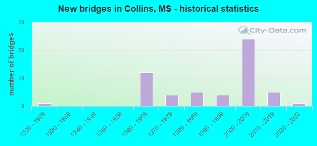
- New bridges - historical statistics
- 11920-1929
- 121960-1969
- 41970-1979
- 51980-1989
- 41990-1999
- 242000-2009
- 52010-2019
- 12020-2022


- Bridge Condition - Deck
- 3.6%Excellent
- 53.6%Very good
- 25.0%Good
- 14.3%Satisfactory
- 3.6%Fair

- Bridge Condition - Superstructure
- 3.6%Excellent
- 67.9%Very good
- 17.9%Good
- 7.1%Satisfactory
- 3.6%Fair

- Bridge Condition - Substructure
- 3.6%Excellent
- 71.4%Very good
- 14.3%Good
- 7.1%Satisfactory
- 3.6%Critical

- Bridge Condition - Channel
- 20.0%Very good
- 45.0%Good
- 17.5%Satisfactory
- 15.0%Fair
- 2.5%Poor

- Bridge Condition - Culverts
- 40.0%Very good
- 60.0%Good
Find on map >> Show street view
Structure Number: 21000490160922B, Location: 2.0 MI N SR 590 (Lat: 31.588917, Lng: -89.526003), Route carried "on" structure: US 49, Year Built: 1964, Status: Open, Structure Length: 0.91m (2.99ft), Average Daily Traffic: 12,500 (year 2020), Truck Traffic: 15%, Average Future Daily Traffic: 14,000 (year 2040), Design Load: HS 15, Features Intersected: KELLY CREEK
Minimum Vertical Clearance: 30+ m (98+ ft), Kilometerpoint: 19.983, Lanes on structure: 2, Base Highway Network: Yes (Inventory Route: 4, Subroute: 1), Owner: State Highway Agency, Approaching Roadway Width: 13.4m (44.0ft), Material/Design: Concrete, Design/Construction: Culvert, Number Of Spans In Main Unit: 2, Length of Maximum Span: 4.3m (14.1ft)
Condition: Channel: Fair, Culverts: Good, Operating Rating: 58.5 metric tons, Method Used To Determine Operating Rating: Load Factor (LF), Inventory Rating: 35.1 metric tons, Method Used To Determine Inventory Rating: Load Factor (LF), Structural Evaluation: Better than present minimum criteria, Waterway Adequacy: Equal to present desirable criteria, Approach Roadway Alignment: Equal to present desirable criteria, Designated Inspection Frequency: Every 24 months, Inspection Date: June 2021
Find on map >> Show street view
Structure Number: 21000490160977, Location: 1.2 MI N SR 184 (Lat: 31.655047, Lng: -89.572553), Route carried "on" structure: US 49, Year Built: 1965, Status: Open, Structure Length: 0.61m (2.00ft), Average Daily Traffic: 23,000 (year 2020), Truck Traffic: 19%, Average Future Daily Traffic: 26,000 (year 2040), Design Load: H 15, Features Intersected: UNNAMED STREAM
Minimum Vertical Clearance: 30+ m (98+ ft), Kilometerpoint: 28.833, Lanes on structure: 5, Base Highway Network: Yes (Inventory Route: 4, Subroute: 1), Owner: State Highway Agency, Approaching Roadway Width: 28.0m (91.9ft), Material/Design: Concrete, Design/Construction: Culvert, Number Of Spans In Main Unit: 2, Length of Maximum Span: 3.0m (9.8ft)
Condition: Channel: Very good, Culverts: Good, Operating Rating: 59.4 metric tons, Method Used To Determine Operating Rating: Load Factor (LF), Inventory Rating: 35.1 metric tons, Method Used To Determine Inventory Rating: Load Factor (LF), Structural Evaluation: Better than present minimum criteria, Waterway Adequacy: Equal to present desirable criteria, Approach Roadway Alignment: Equal to present desirable criteria, Length Of Structure Improvement: 0.70m (2.30ft), Designated Inspection Frequency: Every 24 months, Inspection Date: June 2021, Bridge Improvement Cost: $61,000,000, Roadway Improvement Cost: $200,000,000, Total Project Cost: $303,000,000
Find on map >> Show street view
Structure Number: 21000490160978, Location: 1.3 MI N SR 184 (Lat: 31.655761, Lng: -89.573225), Route carried "on" structure: US 49, Year Built: 1965, Status: Open, Structure Length: 1.11m (3.64ft), Average Daily Traffic: 23,000 (year 2020), Truck Traffic: 19%, Average Future Daily Traffic: 26,000 (year 2040), Design Load: HS 20+Mod, Features Intersected: UNNAMED STREAM
Minimum Vertical Clearance: 30+ m (98+ ft), Kilometerpoint: 28.934, Lanes on structure: 6, Base Highway Network: Yes (Inventory Route: 4, Subroute: 1), Owner: State Highway Agency, Approaching Roadway Width: 34.7m (113.8ft), Material/Design: Concrete, Design/Construction: Culvert, Number Of Spans In Main Unit: 3, Length of Maximum Span: 3.7m (12.1ft)
Condition: Channel: Very good, Culverts: Good, Operating Rating: 44.5 metric tons, Method Used To Determine Operating Rating: Load Factor (LF), Inventory Rating: 26.7 metric tons, Method Used To Determine Inventory Rating: Load Factor (LF), Structural Evaluation: Equal to present minimum criteria, Waterway Adequacy: Equal to present desirable criteria, Approach Roadway Alignment: Equal to present desirable criteria, Designated Inspection Frequency: Every 24 months, Inspection Date: June 2021
Find on map >> Show street view
Structure Number: 21000490161004A, Location: 5.5 MI S SR 35 (Lat: 31.685278, Lng: -89.600956), Route carried "on" structure: US 49, Year Built: 2001, Status: Open, Structure Length: 3.60m (11.81ft), Average Daily Traffic: 10,500 (year 2020), Truck Traffic: 21%, Average Future Daily Traffic: 11,500 (year 2040), Design Load: HS 20, Features Intersected: BURTON CREEK
Minimum Vertical Clearance: 30+ m (98+ ft), Kilometerpoint: 13.201, Lanes on structure: 2, Base Highway Network: Yes (Inventory Route: 4, Subroute: 1), Owner: State Highway Agency, Approaching Roadway Width: 12.0m (39.4ft), Skew: 10 degrees, Material/Design: Prestressed concrete continuous, Design/Construction: Stringer/Multi-beam, Number Of Spans In Main Unit: 3, Length of Maximum Span: 12.0m (39.4ft), Curb-To-Curb Width: 12.0m (39.4ft), Out-to-Out Width: 12.9m (42.3ft)
Condition: Deck: Very good, Superstructure: Very good, Substructure: Very good, Channel: Good, Operating Rating: 61.6 metric tons, Method Used To Determine Operating Rating: Load Factor (LF), Inventory Rating: 36.8 metric tons, Method Used To Determine Inventory Rating: Load Factor (LF), Structural Evaluation: Equal to present desirable criteria, Deck Geometry: Better than present minimum criteria, Waterway Adequacy: Equal to present desirable criteria, Approach Roadway Alignment: Equal to present desirable criteria, Designated Inspection Frequency: Every 24 months, Inspection Date: July 2021, Deck Structure Type: Concrete Cast-file-Place
Find on map >> Show street view
Structure Number: 21000490161004B, Location: 5.5 MI S SR 35 (Lat: 31.685306, Lng: -89.600458), Route carried "on" structure: US 49, Year Built: 1964, Status: Open, Structure Length: 3.05m (10.01ft), Average Daily Traffic: 10,500 (year 2020), Truck Traffic: 21%, Average Future Daily Traffic: 11,500 (year 2040), Design Load: HS 20, Features Intersected: BURTON CREEK
Minimum Vertical Clearance: 30+ m (98+ ft), Kilometerpoint: 33.111, Lanes on structure: 2, Base Highway Network: Yes (Inventory Route: 4, Subroute: 1), Owner: State Highway Agency, Approaching Roadway Width: 8.6m (28.2ft), Material/Design: Concrete, Design/Construction: Slab, Number Of Spans In Main Unit: 5, Length of Maximum Span: 6.1m (20.0ft), Curb or Sidewalk Widths: Left: 0.5m (1.6ft), Right: 0.5m (1.6ft), Curb-To-Curb Width: 8.6m (28.2ft), Out-to-Out Width: 10.0m (32.8ft)
Condition: Deck: Satisfactory, Superstructure: Satisfactory, Substructure: Good, Channel: Fair, Operating Rating: 64.3 metric tons, Method Used To Determine Operating Rating: Load Factor (LF), Inventory Rating: 38.5 metric tons, Method Used To Determine Inventory Rating: Load Factor (LF), Structural Evaluation: Equal to present minimum criteria, Deck Geometry: High priority of corrective action, Waterway Adequacy: Equal to present desirable criteria, Approach Roadway Alignment: Equal to present desirable criteria, Length Of Structure Improvement: 3.96m (12.99ft), Designated Inspection Frequency: Every 24 months, Inspection Date: July 2021, Bridge Improvement Cost: $307,000,000, Roadway Improvement Cost: $31,000,000, Total Project Cost: $915,000,000, Deck Structure Type: Concrete Cast-file-Place
Find on map >> Show street view
Structure Number: 21000800250277, Location: 7.6 MI E SR 22 (Lat: 32.360539, Lng: -90.475950), Route carried "on" structure: US 80, Year Built: 1927, Status: Open, Structure Length: 2.80m (9.19ft), Average Daily Traffic: 320 (year 2020), Truck Traffic: 17%, Average Future Daily Traffic: 320 (year 2040), Design Load: H 15, Features Intersected: FLEETWOOD CREEK
Minimum Vertical Clearance: 30+ m (98+ ft), Kilometerpoint: 0.357, Lanes on structure: 2, Owner: State Highway Agency, Approaching Roadway Width: 8.5m (27.9ft), Material/Design: Concrete, Design/Construction: Tee Beam, Number Of Spans In Main Unit: 3, Number Of Approach Spans: 2, Length of Maximum Span: 7.0m (23.0ft), Curb or Sidewalk Widths: Left: 0.2m (0.7ft), Right: 0.2m (0.7ft), Curb-To-Curb Width: 5.6m (18.4ft), Out-to-Out Width: 6.3m (20.7ft)
Condition: Deck: Satisfactory, Superstructure: Satisfactory, Substructure: Satisfactory, Channel: Good, Operating Rating: 60.3 metric tons, Method Used To Determine Operating Rating: Load Factor (LF), Inventory Rating: 36.2 metric tons, Method Used To Determine Inventory Rating: Load Factor (LF), Structural Evaluation: Equal to present minimum criteria, Deck Geometry: High priority of corrective action, Waterway Adequacy: Equal to present desirable criteria, Approach Roadway Alignment: Equal to present desirable criteria, Length Of Structure Improvement: 4.04m (13.25ft), Designated Inspection Frequency: Every 24 months, Inspection Date: June 2020, Bridge Improvement Cost: $314,000,000, Roadway Improvement Cost: $31,000,000, Total Project Cost: $936,000,000, Deck Structure Type: Concrete Cast-file-Place, Wearing Surface/Protective System: Wearing Surface: Bituminous
Find on map >> Show street view
Structure Number: 21000840161178, Location: 4.0 MI W US 49 (Lat: 31.624106, Lng: -89.626400), Route carried "on" structure: US 84, Year Built: 2001, Status: Open, Structure Length: 1.05m (3.44ft), Average Daily Traffic: 6,300 (year 2020), Truck Traffic: 24%, Average Future Daily Traffic: 7,000 (year 2040), Design Load: HS 20, Features Intersected: STREAM
Minimum Vertical Clearance: 30+ m (98+ ft), Kilometerpoint: 12.854, Lanes on structure: 4, Base Highway Network: Yes (Inventory Route: 8, Subroute: 1), Owner: State Highway Agency, Approaching Roadway Width: 23.5m (77.1ft), Skew: 1 degrees, Material/Design: Concrete, Design/Construction: Culvert, Number Of Spans In Main Unit: 2, Length of Maximum Span: 4.9m (16.1ft)
Condition: Channel: Good, Culverts: Very good, Operating Rating: 43.0 metric tons, Method Used To Determine Operating Rating: Load Factor (LF), Inventory Rating: 25.7 metric tons, Method Used To Determine Inventory Rating: Load Factor (LF), Structural Evaluation: Equal to present minimum criteria, Waterway Adequacy: Equal to present desirable criteria, Approach Roadway Alignment: Equal to present desirable criteria, Designated Inspection Frequency: Every 24 months, Inspection Date: July 2021
Find on map >> Show street view
Structure Number: 21000840161187, Location: 3.0 MI W US 49 (Lat: 31.626836, Lng: -89.611200), Route carried "on" structure: US 84, Year Built: 2001, Status: Open, Structure Length: 1.16m (3.81ft), Average Daily Traffic: 6,300 (year 2020), Truck Traffic: 24%, Average Future Daily Traffic: 7,000 (year 2040), Design Load: HS 20, Features Intersected: STREAM
Minimum Vertical Clearance: 30+ m (98+ ft), Kilometerpoint: 14.328, Lanes on structure: 4, Base Highway Network: Yes (Inventory Route: 8, Subroute: 1), Owner: State Highway Agency, Approaching Roadway Width: 23.5m (77.1ft), Skew: 3 degrees, Material/Design: Concrete, Design/Construction: Culvert, Number Of Spans In Main Unit: 2, Length of Maximum Span: 4.9m (16.1ft)
Condition: Channel: Good, Culverts: Very good, Operating Rating: 56.5 metric tons, Method Used To Determine Operating Rating: Load Factor (LF), Inventory Rating: 33.8 metric tons, Method Used To Determine Inventory Rating: Load Factor (LF), Structural Evaluation: Equal to present desirable criteria, Waterway Adequacy: Equal to present desirable criteria, Approach Roadway Alignment: Equal to present desirable criteria, Designated Inspection Frequency: Every 24 months, Inspection Date: July 2021
Find on map >> Show street view
Structure Number: 21000840161192, Location: 2.6 MI W US 49 (Lat: 31.628306, Lng: -89.604997), Route carried "on" structure: US 84, Year Built: 2001, Status: Open, Structure Length: 0.73m (2.40ft), Average Daily Traffic: 6,300 (year 2020), Truck Traffic: 24%, Average Future Daily Traffic: 7,000 (year 2040), Design Load: HS 20, Features Intersected: STREAM
Minimum Vertical Clearance: 30+ m (98+ ft), Kilometerpoint: 14.938, Lanes on structure: 4, Base Highway Network: Yes (Inventory Route: 8, Subroute: 1), Owner: State Highway Agency, Approaching Roadway Width: 23.5m (77.1ft), Skew: 3 degrees, Material/Design: Concrete, Design/Construction: Culvert, Number Of Spans In Main Unit: 2, Length of Maximum Span: 3.0m (9.8ft)
Condition: Channel: Good, Culverts: Very good, Operating Rating: 99.8 metric tons, Method Used To Determine Operating Rating: Load Factor (LF), Inventory Rating: 68.2 metric tons, Method Used To Determine Inventory Rating: Load Factor (LF), Structural Evaluation: Equal to present desirable criteria, Waterway Adequacy: Equal to present desirable criteria, Approach Roadway Alignment: Equal to present desirable criteria, Designated Inspection Frequency: Every 24 months, Inspection Date: July 2021
Find on map >> Show street view
Structure Number: 21000840161214A, Location: SR 184 OVER US 49 (Lat: 31.638944, Lng: -89.562481), Route carried "on" structure: State highway 184, Year Built: 1964, Status: Open, Structure Length: 7.22m (23.69ft), Average Daily Traffic: 2,000 (year 2020), Truck Traffic: 11%, Average Future Daily Traffic: 2,000 (year 2040), Design Load: HS 20, Features Intersected: US 49
Minimum Vertical Clearance: 30+ m (98+ ft), Kilometerpoint: 1.006, Lanes on structure: 2, Lanes under structure: 4, Owner: State Highway Agency, Approaching Roadway Width: 8.6m (28.2ft), Material/Design: Prestressed concrete, Design/Construction: Stringer/Multi-beam, Number Of Spans In Main Unit: 4, Length of Maximum Span: 18.3m (60.0ft), Curb-To-Curb Width: 8.6m (28.2ft), Out-to-Out Width: 10.0m (32.8ft)
Condition: Deck: Very good, Superstructure: Very good, Substructure: Very good, Operating Rating: 64.6 metric tons, Method Used To Determine Operating Rating: Load Factor (LF), Inventory Rating: 38.7 metric tons, Method Used To Determine Inventory Rating: Load Factor (LF), Structural Evaluation: Equal to present desirable criteria, Deck Geometry: High priority of corrective action, Underclear: Equal to present minimum criteria, Approach Roadway Alignment: Equal to present desirable criteria, Length Of Structure Improvement: 8.32m (27.30ft), Designated Inspection Frequency: Every 24 months, Inspection Date: June 2021, Bridge Improvement Cost: $546,000,000, Roadway Improvement Cost: $55,000,000, Total Project Cost: $819,000,000, Deck Structure Type: Concrete Cast-file-Place
Find on map >> Show street view
Structure Number: 21000840161214B, Location: SR 184 OVER US 49 (Lat: 31.638497, Lng: -89.563033), Route carried "on" structure: State highway 184, Year Built: 1964, Status: Open, Structure Length: 7.22m (23.69ft), Average Daily Traffic: 2,000 (year 2020), Truck Traffic: 10%, Average Future Daily Traffic: 2,000 (year 2040), Design Load: HS 20, Features Intersected: US 49
Minimum Vertical Clearance: 30+ m (98+ ft), Kilometerpoint: 2.601, Lanes on structure: 2, Lanes under structure: 4, Owner: State Highway Agency, Approaching Roadway Width: 8.6m (28.2ft), Material/Design: Prestressed concrete, Design/Construction: Stringer/Multi-beam, Number Of Spans In Main Unit: 4, Length of Maximum Span: 18.3m (60.0ft), Curb-To-Curb Width: 8.6m (28.2ft), Out-to-Out Width: 10.0m (32.8ft)
Condition: Deck: Very good, Superstructure: Very good, Substructure: Very good, Operating Rating: 64.6 metric tons, Method Used To Determine Operating Rating: Load Factor (LF), Inventory Rating: 38.7 metric tons, Method Used To Determine Inventory Rating: Load Factor (LF), Structural Evaluation: Equal to present desirable criteria, Deck Geometry: High priority of corrective action, Underclear: Equal to present minimum criteria, Approach Roadway Alignment: Equal to present desirable criteria, Length Of Structure Improvement: 8.32m (27.30ft), Designated Inspection Frequency: Every 24 months, Inspection Date: June 2021, Bridge Improvement Cost: $546,000,000, Roadway Improvement Cost: $55,000,000, Total Project Cost: $819,000,000, Deck Structure Type: Concrete Cast-file-Place
Find on map >> Show street view
Structure Number: 21000840161220A, Location: US 84 OVER US 49 (Lat: 31.654708, Lng: -89.571758), Route carried "on" structure: US 84, Year Built: 2009, Status: Open, Structure Length: 9.82m (32.22ft), Average Daily Traffic: 2,000 (year 2020), Truck Traffic: 25%, Average Future Daily Traffic: 2,200 (year 2040), Design Load: HS 20, Features Intersected: US 49
Minimum Vertical Clearance: 30+ m (98+ ft), Kilometerpoint: 18.084, Lanes on structure: 3, Lanes under structure: 4, Base Highway Network: Yes (Inventory Route: 8, Subroute: 1), Owner: State Highway Agency, Approaching Roadway Width: 15.9m (52.2ft), Skew: 10 degrees, Material/Design: Prestressed concrete continuous, Design/Construction: Stringer/Multi-beam, Number Of Spans In Main Unit: 4, Length of Maximum Span: 24.7m (81.0ft), Curb-To-Curb Width: 15.9m (52.2ft), Out-to-Out Width: 16.7m (54.8ft)
Condition: Deck: Very good, Superstructure: Very good, Substructure: Very good, Operating Rating: 69.5 metric tons, Method Used To Determine Operating Rating: Load Factor (LF), Inventory Rating: 35.0 metric tons, Method Used To Determine Inventory Rating: Load Factor (LF), Structural Evaluation: Equal to present desirable criteria, Deck Geometry: Better than present minimum criteria, Underclear: Better than present minimum criteria, Approach Roadway Alignment: Equal to present desirable criteria, Designated Inspection Frequency: Every 24 months, Inspection Date: July 2021, Deck Structure Type: Concrete Cast-file-Place
Find on map >> Show street view
Structure Number: 21000840161220B, Location: US 84 OVER US 49 (Lat: 31.654003, Lng: -89.572436), Route carried "on" structure: US 84, Year Built: 2009, Status: Open, Structure Length: 9.82m (32.22ft), Average Daily Traffic: 2,000 (year 2020), Truck Traffic: 25%, Average Future Daily Traffic: 2,200 (year 2040), Design Load: HS 20, Features Intersected: US 49
Minimum Vertical Clearance: 30+ m (98+ ft), Kilometerpoint: 19.438, Lanes on structure: 3, Lanes under structure: 4, Base Highway Network: Yes (Inventory Route: 8, Subroute: 1), Owner: State Highway Agency, Approaching Roadway Width: 15.9m (52.2ft), Skew: 10 degrees, Material/Design: Prestressed concrete continuous, Design/Construction: Stringer/Multi-beam, Number Of Spans In Main Unit: 4, Length of Maximum Span: 24.7m (81.0ft), Curb-To-Curb Width: 15.9m (52.2ft), Out-to-Out Width: 16.7m (54.8ft)
Condition: Deck: Very good, Superstructure: Very good, Substructure: Very good, Operating Rating: 69.5 metric tons, Method Used To Determine Operating Rating: Load Factor (LF), Inventory Rating: 35.0 metric tons, Method Used To Determine Inventory Rating: Load Factor (LF), Structural Evaluation: Equal to present desirable criteria, Deck Geometry: Better than present minimum criteria, Underclear: Better than present minimum criteria, Approach Roadway Alignment: Equal to present desirable criteria, Designated Inspection Frequency: Every 24 months, Inspection Date: July 2021, Deck Structure Type: Concrete Cast-file-Place
Find on map >> Show street view
Structure Number: 21000840161225B, Location: 0.2 MI E US 49 (Lat: 31.656672, Lng: -89.568339), Route carried "on" structure: US 84, Year Built: 2009, Status: Open, Structure Length: 11.05m (36.25ft), Average Daily Traffic: 2,000 (year 2020), Truck Traffic: 25%, Average Future Daily Traffic: 2,200 (year 2040), Design Load: HS 20, Features Intersected: CNIC RR
Minimum Vertical Clearance: 30+ m (98+ ft), Kilometerpoint: 17.693, Lanes on structure: 2, Base Highway Network: Yes (Inventory Route: 8, Subroute: 1), Owner: State Highway Agency, Approaching Roadway Width: 12.2m (40.0ft), Skew: 11 degrees, Material/Design: Prestressed concrete continuous, Design/Construction: Stringer/Multi-beam, Number Of Spans In Main Unit: 4, Length of Maximum Span: 27.4m (89.9ft), Curb-To-Curb Width: 12.2m (40.0ft), Out-to-Out Width: 13.0m (42.7ft)
Condition: Deck: Very good, Superstructure: Very good, Substructure: Very good, Operating Rating: 70.5 metric tons, Method Used To Determine Operating Rating: Load Factor (LF), Inventory Rating: 35.4 metric tons, Method Used To Determine Inventory Rating: Load Factor (LF), Structural Evaluation: Equal to present desirable criteria, Deck Geometry: Better than present minimum criteria, Underclear: Superior to present desirable criteria, Approach Roadway Alignment: Equal to present desirable criteria, Designated Inspection Frequency: Every 24 months, Inspection Date: July 2021, Deck Structure Type: Concrete Cast-file-Place
Find on map >> Show street view
Structure Number: 21000840161225C, Location: 0.2 MI E US 49 (Lat: 31.655950, Lng: -89.569075), Route carried "on" structure: US 84, Year Built: 2009, Status: Open, Structure Length: 11.05m (36.25ft), Average Daily Traffic: 2,000 (year 2020), Truck Traffic: 25%, Average Future Daily Traffic: 2,200 (year 2040), Design Load: HS 20, Features Intersected: CNIC RR
Minimum Vertical Clearance: 30+ m (98+ ft), Kilometerpoint: 19.822, Lanes on structure: 2, Base Highway Network: Yes (Inventory Route: 8, Subroute: 1), Owner: State Highway Agency, Approaching Roadway Width: 12.2m (40.0ft), Skew: 11 degrees, Material/Design: Prestressed concrete continuous, Design/Construction: Stringer/Multi-beam, Number Of Spans In Main Unit: 4, Length of Maximum Span: 27.4m (89.9ft), Curb-To-Curb Width: 12.2m (40.0ft), Out-to-Out Width: 13.0m (42.7ft)
Condition: Deck: Very good, Superstructure: Very good, Substructure: Very good, Operating Rating: 70.5 metric tons, Method Used To Determine Operating Rating: Load Factor (LF), Inventory Rating: 35.4 metric tons, Method Used To Determine Inventory Rating: Load Factor (LF), Structural Evaluation: Equal to present desirable criteria, Deck Geometry: Better than present minimum criteria, Underclear: Equal to present desirable criteria, Approach Roadway Alignment: Equal to present desirable criteria, Designated Inspection Frequency: Every 24 months, Inspection Date: July 2021, Deck Structure Type: Concrete Cast-file-Place
Find on map >> Show street view
Structure Number: 21000840161226, Location: 0.4 MI E US 49 (Lat: 31.647325, Lng: -89.553733), Route carried "on" structure: State highway 184, Year Built: 1971, Status: Open, Structure Length: 21.95m (72.01ft), Average Daily Traffic: 8,300 (year 2020), Truck Traffic: 5%, Average Future Daily Traffic: 8,300 (year 2040), Design Load: HS 20, Features Intersected: OKATOMA CREEK
Minimum Vertical Clearance: 30+ m (98+ ft), Kilometerpoint: 3.930, Lanes on structure: 3, Owner: State Highway Agency, Approaching Roadway Width: 26.9m (88.3ft), Skew: 10 degrees, Material/Design: Prestressed concrete, Design/Construction: Stringer/Multi-beam, Number Of Spans In Main Unit: 3, Number Of Approach Spans: 12, Length of Maximum Span: 24.4m (80.1ft), Curb-To-Curb Width: 26.9m (88.3ft), Out-to-Out Width: 27.8m (91.2ft)
Condition: Deck: Very good, Superstructure: Very good, Substructure: Very good, Channel: Satisfactory, Operating Rating: 48.2 metric tons, Method Used To Determine Operating Rating: Load Factor (LF), Inventory Rating: 28.8 metric tons, Method Used To Determine Inventory Rating: Load Factor (LF), Structural Evaluation: Better than present minimum criteria, Deck Geometry: Superior to present desirable criteria, Waterway Adequacy: Equal to present desirable criteria, Approach Roadway Alignment: Equal to present desirable criteria, Length Of Structure Improvement: 21.95m (72.01ft), Designated Inspection Frequency: Every 24 months, Inspection Date: June 2021, Bridge Improvement Cost: $999,999,000, Roadway Improvement Cost: $200,000,000, Total Project Cost: $999,999,000, Deck Structure Type: Concrete Cast-file-Place
Find on map >> Show street view
Structure Number: 21000840161228A, Location: 0.5 MI E US 49 (Lat: 31.657964, Lng: -89.562386), Route carried "on" structure: US 84, Year Built: 2009, Status: Open, Structure Length: 28.72m (94.23ft), Average Daily Traffic: 2,750 (year 2020), Truck Traffic: 33%, Average Future Daily Traffic: 3,050 (year 2040), Design Load: HS 20, Features Intersected: OKATOMA CREEK
Minimum Vertical Clearance: 30+ m (98+ ft), Kilometerpoint: 17.101, Lanes on structure: 2, Base Highway Network: Yes (Inventory Route: 8, Subroute: 1), Owner: State Highway Agency, Approaching Roadway Width: 12.2m (40.0ft), Skew: 10 degrees, Material/Design: Prestressed concrete, Design/Construction: Stringer/Multi-beam, Number Of Spans In Main Unit: 1, Number Of Approach Spans: 10, Length of Maximum Span: 42.7m (140.1ft), Curb-To-Curb Width: 12.2m (40.0ft), Out-to-Out Width: 13.0m (42.7ft)
Condition: Deck: Very good, Superstructure: Very good, Substructure: Very good, Channel: Very good, Operating Rating: 67.1 metric tons, Method Used To Determine Operating Rating: Load Factor (LF), Inventory Rating: 17.7 metric tons, Method Used To Determine Inventory Rating: Load Factor (LF), Structural Evaluation: Meets minimum limits, Deck Geometry: Better than present minimum criteria, Waterway Adequacy: Equal to present desirable criteria, Approach Roadway Alignment: Equal to present desirable criteria, Designated Inspection Frequency: Every 24 months, Inspection Date: July 2021, Deck Structure Type: Concrete Cast-file-Place
Find on map >> Show street view
Structure Number: 21000840161228B, Location: 0.5 MI E US 49 (Lat: 31.657514, Lng: -89.565417), Route carried "on" structure: US 84, Year Built: 2009, Status: Open, Structure Length: 28.72m (94.23ft), Average Daily Traffic: 2,750 (year 2020), Truck Traffic: 31%, Average Future Daily Traffic: 3,050 (year 2040), Design Load: HS 20, Features Intersected: OKATOMA CREEK
Minimum Vertical Clearance: 30+ m (98+ ft), Kilometerpoint: 20.212, Lanes on structure: 3, Base Highway Network: Yes (Inventory Route: 8, Subroute: 1), Owner: State Highway Agency, Approaching Roadway Width: 15.9m (52.2ft), Skew: 10 degrees, Material/Design: Prestressed concrete, Design/Construction: Stringer/Multi-beam, Number Of Spans In Main Unit: 1, Number Of Approach Spans: 10, Length of Maximum Span: 42.7m (140.1ft), Curb-To-Curb Width: 15.9m (52.2ft), Out-to-Out Width: 16.7m (54.8ft)
Condition: Deck: Very good, Superstructure: Very good, Substructure: Very good, Channel: Very good, Operating Rating: 66.7 metric tons, Method Used To Determine Operating Rating: Load Factor (LF), Inventory Rating: 35.0 metric tons, Method Used To Determine Inventory Rating: Load Factor (LF), Structural Evaluation: Equal to present desirable criteria, Deck Geometry: Better than present minimum criteria, Waterway Adequacy: Equal to present desirable criteria, Approach Roadway Alignment: Equal to present desirable criteria, Designated Inspection Frequency: Every 24 months, Inspection Date: July 2021, Deck Structure Type: Concrete Cast-file-Place
Find on map >> Show street view
Structure Number: 21000840161231, Location: 1.3 MI E US 49 (Lat: 31.650972, Lng: -89.547650), Route carried "on" structure: US 84, Year Built: 1980, Status: Open, Structure Length: 1.77m (5.81ft), Average Daily Traffic: 7,700 (year 2020), Truck Traffic: 22%, Average Future Daily Traffic: 8,500 (year 2040), Design Load: HS 20+Mod, Features Intersected: RODGERS CREEK
Minimum Vertical Clearance: 30+ m (98+ ft), Kilometerpoint: 22.122, Lanes on structure: 4, Base Highway Network: Yes (Inventory Route: 8, Subroute: 1), Owner: State Highway Agency, Approaching Roadway Width: 14.6m (47.9ft), Material/Design: Concrete, Design/Construction: Culvert, Number Of Spans In Main Unit: 3, Length of Maximum Span: 5.5m (18.0ft)
Condition: Channel: Fair, Culverts: Good, Operating Rating: 73.0 metric tons, Method Used To Determine Operating Rating: Load Factor (LF), Inventory Rating: 43.7 metric tons, Method Used To Determine Inventory Rating: Load Factor (LF), Structural Evaluation: Better than present minimum criteria, Waterway Adequacy: Equal to present desirable criteria, Approach Roadway Alignment: Equal to present desirable criteria, Length Of Structure Improvement: 1.77m (5.81ft), Designated Inspection Frequency: Every 24 months, Inspection Date: July 2021, Bridge Improvement Cost: $221,000,000, Roadway Improvement Cost: $200,000,000, Total Project Cost: $488,000,000, Deck Structure Type: Concrete Cast-file-Place
Find on map >> Show street view
Structure Number: 21000840161258B, Location: 2.9 MI W SR 37 (Lat: 31.666189, Lng: -89.506722), Route carried "on" structure: US 84, Year Built: 1980, Status: Open, Structure Length: 4.66m (15.29ft), Average Daily Traffic: 3,850 (year 2020), Truck Traffic: 22%, Average Future Daily Traffic: 4,250 (year 2040), Design Load: HS 20, Features Intersected: STATION CREEK
Minimum Vertical Clearance: 30+ m (98+ ft), Kilometerpoint: 26.382, Lanes on structure: 2, Base Highway Network: Yes (Inventory Route: 8, Subroute: 1), Owner: State Highway Agency, Approaching Roadway Width: 11.8m (38.7ft), Skew: 3 degrees, Material/Design: Prestressed concrete, Design/Construction: Stringer/Multi-beam, Number Of Spans In Main Unit: 3, Length of Maximum Span: 15.2m (49.9ft), Curb-To-Curb Width: 11.8m (38.7ft), Out-to-Out Width: 12.6m (41.3ft)
Condition: Deck: Very good, Superstructure: Very good, Substructure: Very good, Channel: Good, Operating Rating: 45.0 metric tons, Method Used To Determine Operating Rating: Load Factor (LF), Inventory Rating: 26.9 metric tons, Method Used To Determine Inventory Rating: Load Factor (LF), Structural Evaluation: Equal to present minimum criteria, Deck Geometry: Better than present minimum criteria, Waterway Adequacy: Equal to present desirable criteria, Approach Roadway Alignment: Equal to present desirable criteria, Designated Inspection Frequency: Every 24 months, Inspection Date: July 2021, Deck Structure Type: Concrete Cast-file-Place
Find on map >> Show street view
Structure Number: 21000840161259A, Location: 2.9 MI W SR 37 (Lat: 31.666644, Lng: -89.506744), Route carried "on" structure: US 84, Year Built: 2009, Status: Open, Structure Length: 4.25m (13.94ft), Average Daily Traffic: 3,850 (year 2020), Truck Traffic: 18%, Average Future Daily Traffic: 4,250 (year 2040), Design Load: HS 20, Features Intersected: STATION CREEK
Minimum Vertical Clearance: 30+ m (98+ ft), Kilometerpoint: 11.212, Lanes on structure: 2, Base Highway Network: Yes (Inventory Route: 8, Subroute: 1), Owner: State Highway Agency, Approaching Roadway Width: 12.0m (39.4ft), Material/Design: Prestressed concrete, Design/Construction: Stringer/Multi-beam, Number Of Spans In Main Unit: 1, Number Of Approach Spans: 2, Length of Maximum Span: 18.0m (59.1ft), Curb-To-Curb Width: 12.0m (39.4ft), Out-to-Out Width: 12.9m (42.3ft)
Condition: Deck: Very good, Superstructure: Very good, Substructure: Very good, Channel: Good, Operating Rating: 54.9 metric tons, Method Used To Determine Operating Rating: Load Factor (LF), Inventory Rating: 27.9 metric tons, Method Used To Determine Inventory Rating: Load Factor (LF), Structural Evaluation: Better than present minimum criteria, Deck Geometry: Better than present minimum criteria, Waterway Adequacy: Equal to present desirable criteria, Approach Roadway Alignment: Equal to present desirable criteria, Designated Inspection Frequency: Every 24 months, Inspection Date: July 2021, Deck Structure Type: Concrete Cast-file-Place
Find on map >> Show street view
Structure Number: 27000490160977A, Location: US 49/US 84 INTCHG (Lat: 31.654908, Lng: -89.573511), Route carried "on" structure: Ramp US 49, Year Built: 2009, Status: Open, Structure Length: 0.61m (2.00ft), Average Daily Traffic: 105 (year 2020), Truck Traffic: 18%, Average Future Daily Traffic: 115 (year 2040), Design Load: HS 20, Features Intersected: UNAMED STREAM
Minimum Vertical Clearance: 30+ m (98+ ft), Kilometerpoint: 0.100, Lanes on structure: 1, Owner: State Highway Agency, Approaching Roadway Width: 4.9m (16.1ft), Material/Design: Concrete, Design/Construction: Culvert, Number Of Spans In Main Unit: 2, Length of Maximum Span: 3.0m (9.8ft)
Condition: Channel: Very good, Culverts: Very good, Operating Rating: 41.5 metric tons, Method Used To Determine Operating Rating: Load Factor (LF), Inventory Rating: 24.9 metric tons, Method Used To Determine Inventory Rating: Load Factor (LF), Structural Evaluation: Equal to present minimum criteria, Waterway Adequacy: Equal to present desirable criteria, Approach Roadway Alignment: Equal to present desirable criteria, Designated Inspection Frequency: Every 24 months, Inspection Date: July 2021
Find on map >> Show street view
Structure Number: 27000490160977B, Location: US 49/US 84 INTCHG (Lat: 31.655833, Lng: -89.571458), Route carried "on" structure: Ramp US 49, Year Built: 2009, Status: Open, Structure Length: 0.63m (2.07ft), Average Daily Traffic: 405 (year 2020), Truck Traffic: 18%, Average Future Daily Traffic: 450 (year 2040), Design Load: HS 20, Features Intersected: UNAMED STREAM
Minimum Vertical Clearance: 30+ m (98+ ft), Kilometerpoint: 0.225, Lanes on structure: 1, Owner: State Highway Agency, Approaching Roadway Width: 4.9m (16.1ft), Skew: 1 degrees, Material/Design: Concrete, Design/Construction: Culvert, Number Of Spans In Main Unit: 2, Length of Maximum Span: 3.0m (9.8ft)
Condition: Channel: Very good, Culverts: Very good, Operating Rating: 64.5 metric tons, Method Used To Determine Operating Rating: Load Factor (LF), Inventory Rating: 38.7 metric tons, Method Used To Determine Inventory Rating: Load Factor (LF), Structural Evaluation: Equal to present desirable criteria, Waterway Adequacy: Equal to present desirable criteria, Approach Roadway Alignment: Equal to present desirable criteria, Designated Inspection Frequency: Every 24 months, Inspection Date: July 2021
Find on map >> Show street view
Structure Number: 27000490160977C, Location: US 49/US 84 INTCHG (Lat: 31.656300, Lng: -89.570303), Route carried "on" structure: Ramp US 49, Year Built: 2010, Status: Open, Structure Length: 0.72m (2.36ft), Average Daily Traffic: 250 (year 2020), Truck Traffic: 16%, Average Future Daily Traffic: 250 (year 2040), Design Load: HS 20, Features Intersected: UNAMED STREAM
Minimum Vertical Clearance: 30+ m (98+ ft), Kilometerpoint: 0.119, Lanes on structure: 1, Owner: State Highway Agency, Approaching Roadway Width: 4.9m (16.1ft), Skew: 3 degrees, Material/Design: Concrete, Design/Construction: Culvert, Number Of Spans In Main Unit: 2, Length of Maximum Span: 3.0m (9.8ft)
Condition: Channel: Very good, Culverts: Very good, Structural Evaluation: Equal to present desirable criteria, Waterway Adequacy: Equal to present desirable criteria, Approach Roadway Alignment: Equal to present desirable criteria, Designated Inspection Frequency: Every 24 months, Inspection Date: July 2021
Find on map >> Show street view
Structure Number: 27000820781308A, Location: US 82/SR 15 INTERCHANGE (Lat: 33.540258, Lng: -89.108203), Route carried "on" structure: Ramp US 82, Year Built: 2003, Status: Open, Structure Length: 1.87m (6.14ft), Average Daily Traffic: 1,400 (year 2020), Truck Traffic: 18%, Average Future Daily Traffic: 1,400 (year 2040), Design Load: HS 20, Features Intersected: PIGEON ROOST CREEK TRIB
Minimum Vertical Clearance: 30+ m (98+ ft), Kilometerpoint: 0.380, Lanes on structure: 2, Owner: State Highway Agency, Approaching Roadway Width: 7.3m (24.0ft), Skew: 4 degrees, Material/Design: Concrete, Design/Construction: Culvert, Number Of Spans In Main Unit: 2, Length of Maximum Span: 6.1m (20.0ft)
Condition: Channel: Satisfactory, Culverts: Good, Operating Rating: 59.5 metric tons, Method Used To Determine Operating Rating: Load Factor (LF), Inventory Rating: 35.7 metric tons, Method Used To Determine Inventory Rating: Load Factor (LF), Structural Evaluation: Better than present minimum criteria, Waterway Adequacy: Equal to present desirable criteria, Approach Roadway Alignment: Better than present minimum criteria, Designated Inspection Frequency: Every 24 months, Inspection Date: August 2021
Find on map >> Show street view
Structure Number: 27000840161225A, Location: 0.2 MI E US 49 (Lat: 31.657036, Lng: -89.568933), Route carried "on" structure: Ramp US 84, Year Built: 2009, Status: Open, Structure Length: 15.33m (50.30ft), Average Daily Traffic: 800 (year 2020), Truck Traffic: 18%, Average Future Daily Traffic: 850 (year 2040), Design Load: HS 20, Features Intersected: CNIC RR
Minimum Vertical Clearance: 30+ m (98+ ft), Kilometerpoint: 0.425, Lanes on structure: 1, Owner: State Highway Agency, Approaching Roadway Width: 9.8m (32.2ft), Skew: 13 degrees, Material/Design: Prestressed concrete continuous, Design/Construction: Stringer/Multi-beam, Number Of Spans In Main Unit: 5, Length of Maximum Span: 30.5m (100.1ft), Curb-To-Curb Width: 9.8m (32.2ft), Out-to-Out Width: 10.6m (34.8ft)
Condition: Deck: Very good, Superstructure: Very good, Substructure: Very good, Operating Rating: 74.8 metric tons, Method Used To Determine Operating Rating: Load Factor (LF), Inventory Rating: 35.6 metric tons, Method Used To Determine Inventory Rating: Load Factor (LF), Structural Evaluation: Equal to present desirable criteria, Deck Geometry: Superior to present desirable criteria, Underclear: Superior to present desirable criteria, Approach Roadway Alignment: Equal to present desirable criteria, Designated Inspection Frequency: Every 24 months, Inspection Date: July 2021, Deck Structure Type: Concrete Cast-file-Place
Find on map >> Show street view
Structure Number: 27000840161225D, Location: 0.2 MI E US 49 (Lat: 31.655686, Lng: -89.568686), Route carried "on" structure: Ramp US 84, Year Built: 2009, Status: Open, Structure Length: 11.05m (36.25ft), Average Daily Traffic: 340 (year 2020), Truck Traffic: 18%, Average Future Daily Traffic: 375 (year 2040), Design Load: HS 20, Features Intersected: CNIC RR
Minimum Vertical Clearance: 30+ m (98+ ft), Kilometerpoint: 0.455, Lanes on structure: 1, Owner: State Highway Agency, Approaching Roadway Width: 9.8m (32.2ft), Skew: 11 degrees, Material/Design: Prestressed concrete continuous, Design/Construction: Stringer/Multi-beam, Number Of Spans In Main Unit: 4, Length of Maximum Span: 27.4m (89.9ft), Curb-To-Curb Width: 9.8m (32.2ft), Out-to-Out Width: 10.6m (34.8ft)
Condition: Deck: Very good, Superstructure: Very good, Substructure: Very good, Operating Rating: 64.9 metric tons, Method Used To Determine Operating Rating: Load Factor (LF), Inventory Rating: 34.6 metric tons, Method Used To Determine Inventory Rating: Load Factor (LF), Structural Evaluation: Equal to present desirable criteria, Deck Geometry: Superior to present desirable criteria, Underclear: Superior to present desirable criteria, Approach Roadway Alignment: Equal to present desirable criteria, Designated Inspection Frequency: Every 24 months, Inspection Date: July 2021, Deck Structure Type: Concrete Cast-file-Place
Find on map >> Show street view
Structure Number: SA1600000000001, Location: SEC 6 T 6N R14W B (Lat: 31.508744, Lng: -89.439408), Route carried "on" structure: County highway 914, Year Built: 1994, Status: Open, Structure Length: 0.69m (2.26ft), Average Daily Traffic: 320 (year 2018), Truck Traffic: 8%, Average Future Daily Traffic: 480 (year 2038), Design Load: HS 20, Features Intersected: TRIB OF OKATOMA CREEK, Facility Carried by Structure: OLD HWY 49
Minimum Vertical Clearance: 30+ m (98+ ft), Kilometerpoint: 11.909, Lanes on structure: 2, Owner: County Highway Agency, Approaching Roadway Width: 6.7m (22.0ft), Skew: 1 degrees, Material/Design: Concrete, Design/Construction: Culvert, Number Of Spans In Main Unit: 2, Length of Maximum Span: 3.0m (9.8ft)
Condition: Channel: Good, Culverts: Good, Operating Rating: 59.2 metric tons, Method Used To Determine Operating Rating: Load Factor (LF), Inventory Rating: 35.6 metric tons, Method Used To Determine Inventory Rating: Load Factor (LF), Structural Evaluation: Better than present minimum criteria, Waterway Adequacy: Equal to present desirable criteria, Approach Roadway Alignment: Equal to present desirable criteria, Designated Inspection Frequency: Every 24 months, Inspection Date: December 2020
Find on map >> Show street view
Structure Number: SA1600000000025, Location: SEC 6 T 7N R15W B (Lat: 31.597075, Lng: -89.541681), Route carried "on" structure: County highway 118, Year Built: 1981, Status: Open, Structure Length: 0.79m (2.59ft), Average Daily Traffic: 160 (year 2018), Truck Traffic: 8%, Average Future Daily Traffic: 240 (year 2038), Design Load: HS 20, Features Intersected: KELLY CREEK, Facility Carried by Structure: COLD SPRINGS RD
Minimum Vertical Clearance: 30+ m (98+ ft), Kilometerpoint: 4.023, Lanes on structure: 2, Owner: County Highway Agency, Approaching Roadway Width: 6.1m (20.0ft), Material/Design: Concrete, Design/Construction: Culvert, Number Of Spans In Main Unit: 2, Length of Maximum Span: 3.7m (12.1ft)
Condition: Channel: Fair, Culverts: Very good, Operating Rating: 62.4 metric tons, Method Used To Determine Operating Rating: Load Factor (LF), Inventory Rating: 37.3 metric tons, Method Used To Determine Inventory Rating: Load Factor (LF), Structural Evaluation: Equal to present desirable criteria, Waterway Adequacy: Equal to present desirable criteria, Approach Roadway Alignment: Equal to present desirable criteria, Designated Inspection Frequency: Every 24 months, Inspection Date: December 2020
Find on map >> Show street view
Structure Number: SA1600000000033, Location: SEC 1 T 7N R16W B (Lat: 31.596944, Lng: -89.568889), Route carried "on" structure: County highway 913, Year Built: 1970, Status: Open, Structure Length: 2.32m (7.61ft), Average Daily Traffic: 400 (year 2018), Truck Traffic: 8%, Average Future Daily Traffic: 600 (year 2038), Design Load: H 15, Features Intersected: BIG SWAMP CREEK, Facility Carried by Structure: SEMINARY-W'BURG RD
Minimum Vertical Clearance: 30+ m (98+ ft), Kilometerpoint: 4.988, Lanes on structure: 2, Owner: County Highway Agency, Approaching Roadway Width: 6.1m (20.0ft), Material/Design: Concrete, Design/Construction: Channel Beam, Number Of Spans In Main Unit: 4, Length of Maximum Span: 5.8m (19.0ft), Curb or Sidewalk Widths: Left: 0.3m (1.0ft), Right: 0.3m (1.0ft), Curb-To-Curb Width: 8.0m (26.2ft), Out-to-Out Width: 8.6m (28.2ft)
Condition: Deck: Good, Superstructure: Good, Substructure: Satisfactory, Channel: Fair, Operating Rating: 45.3 metric tons, Method Used To Determine Operating Rating: Load Factor (LF), Inventory Rating: 27.1 metric tons, Method Used To Determine Inventory Rating: Load Factor (LF), Structural Evaluation: Equal to present minimum criteria, Deck Geometry: Somewhat better than minimum adequacy, Waterway Adequacy: Equal to present desirable criteria, Approach Roadway Alignment: Equal to present desirable criteria, Length Of Structure Improvement: 3.11m (10.20ft), Designated Inspection Frequency: Every 24 months, Inspection Date: October 2020, Bridge Improvement Cost: $185,000, Roadway Improvement Cost: $20,000, Total Project Cost: $230,000 ( Estimate for 2016), Deck Structure Type: Concrete Precast Panels, Wearing Surface/Protective System: Wearing Surface: Bituminous
Find on map >> Show street view
Structure Number: SA1600000000034, Location: SEC 5 T 7N R16W B (Lat: 31.598642, Lng: -89.626489), Route carried "on" structure: County highway 197, Year Built: 2005, Status: Open, Structure Length: 2.83m (9.28ft), Average Daily Traffic: 1,000 (year 2018), Truck Traffic: 8%, Average Future Daily Traffic: 1,500 (year 2038), Design Load: HS 20, Features Intersected: BCH OF TERRIBLE CREEK, Facility Carried by Structure: LK MIKE CONNER RD
Minimum Vertical Clearance: 30+ m (98+ ft), Kilometerpoint: 4.667, Lanes on structure: 2, Owner: County Highway Agency, Approaching Roadway Width: 7.9m (25.9ft), Material/Design: Concrete, Design/Construction: Channel Beam, Number Of Spans In Main Unit: 3, Length of Maximum Span: 9.4m (30.8ft), Curb or Sidewalk Widths: Left: 0.5m (1.6ft), Right: 0.5m (1.6ft), Curb-To-Curb Width: 8.5m (27.9ft), Out-to-Out Width: 9.5m (31.2ft)
Condition: Deck: Satisfactory, Superstructure: Good, Substructure: Very good, Channel: Good, Operating Rating: 63.1 metric tons, Method Used To Determine Operating Rating: Load Factor (LF), Inventory Rating: 37.9 metric tons, Method Used To Determine Inventory Rating: Load Factor (LF), Structural Evaluation: Better than present minimum criteria, Deck Geometry: Somewhat better than minimum adequacy, Waterway Adequacy: Equal to present desirable criteria, Approach Roadway Alignment: Equal to present minimum criteria, Designated Inspection Frequency: Every 24 months, Inspection Date: December 2020, Deck Structure Type: Concrete Precast Panels, Wearing Surface/Protective System: Wearing Surface: Monolithic Concrete
Find on map >> Show street view
Structure Number: SA1600000000054, Location: SEC 16 T 8N R15W (Lat: 31.664961, Lng: -89.505242), Route carried "on" structure: County highway 111, Year Built: 2001, Status: Open, Structure Length: 2.83m (9.28ft), Average Daily Traffic: 50 (year 2018), Average Future Daily Traffic: 75 (year 2038), Design Load: HS 20, Features Intersected: STATION CREEK, Facility Carried by Structure: TISDALE CUTOFF
Minimum Vertical Clearance: 30+ m (98+ ft), Kilometerpoint: 0.643, Lanes on structure: 2, Owner: County Highway Agency, Approaching Roadway Width: 5.5m (18.0ft), Material/Design: Concrete, Design/Construction: Channel Beam, Number Of Spans In Main Unit: 3, Length of Maximum Span: 9.4m (30.8ft), Curb or Sidewalk Widths: Left: 0.2m (0.7ft), Right: 0.2m (0.7ft), Curb-To-Curb Width: 8.1m (26.6ft), Out-to-Out Width: 8.5m (27.9ft)
Condition: Deck: Good, Superstructure: Very good, Substructure: Very good, Channel: Good, Operating Rating: 75.8 metric tons, Method Used To Determine Operating Rating: Load Factor (LF), Inventory Rating: 45.4 metric tons, Method Used To Determine Inventory Rating: Load Factor (LF), Structural Evaluation: Equal to present desirable criteria, Deck Geometry: Equal to present minimum criteria, Waterway Adequacy: Equal to present desirable criteria, Approach Roadway Alignment: Equal to present desirable criteria, Designated Inspection Frequency: Every 24 months, Inspection Date: November 2020, Deck Structure Type: Concrete Precast Panels, Wearing Surface/Protective System: Wearing Surface: Monolithic Concrete
Find on map >> Show street view
Structure Number: SA1600000000056, Location: SEC 29 T 8N R15W B (Lat: 31.625103, Lng: -89.529014), Route carried "on" structure: County highway 916, Year Built: 2005, Status: Open, Structure Length: 9.75m (31.99ft), Average Daily Traffic: 1,200 (year 2018), Truck Traffic: 8%, Average Future Daily Traffic: 1,800 (year 2038), Design Load: HS 20, Features Intersected: OKATOMA CREEK, Facility Carried by Structure: KOLA RD
Minimum Vertical Clearance: 30+ m (98+ ft), Kilometerpoint: 1.126, Lanes on structure: 2, Owner: County Highway Agency, Approaching Roadway Width: 6.7m (22.0ft), Material/Design: Prestressed concrete, Design/Construction: Stringer/Multi-beam, Number Of Spans In Main Unit: 5, Length of Maximum Span: 30.4m (99.7ft), Curb or Sidewalk Widths: Left: 0.5m (1.6ft), Right: 0.5m (1.6ft), Curb-To-Curb Width: 9.1m (29.9ft), Out-to-Out Width: 10.1m (33.1ft)
Condition: Deck: Satisfactory, Superstructure: Good, Substructure: Good, Channel: Good, Operating Rating: 61.4 metric tons, Method Used To Determine Operating Rating: Load Factor (LF), Inventory Rating: 32.4 metric tons, Method Used To Determine Inventory Rating: Load Factor (LF), Structural Evaluation: Better than present minimum criteria, Deck Geometry: Somewhat better than minimum adequacy, Waterway Adequacy: Equal to present desirable criteria, Approach Roadway Alignment: Equal to present desirable criteria, Designated Inspection Frequency: Every 24 months, Inspection Date: September 2021, Deck Structure Type: Concrete Cast-file-Place, Wearing Surface/Protective System: Wearing Surface: Monolithic Concrete
Find on map >> Show street view
Structure Number: SA1600000000057, Location: SEC 33 T 8N R15W B (Lat: 31.615928, Lng: -89.513497), Route carried "on" structure: County highway 118, Year Built: 1978, Status: Open, Structure Length: 1.05m (3.44ft), Average Daily Traffic: 220 (year 2018), Truck Traffic: 8%, Average Future Daily Traffic: 330 (year 2038), Design Load: HS 20, Features Intersected: BRANCH OF OKATOMA CREEK, Facility Carried by Structure: WATTS RD
Minimum Vertical Clearance: 30+ m (98+ ft), Kilometerpoint: 3.862, Lanes on structure: 2, Owner: County Highway Agency, Approaching Roadway Width: 6.1m (20.0ft), Skew: 3 degrees, Material/Design: Concrete, Design/Construction: Culvert, Number Of Spans In Main Unit: 2, Length of Maximum Span: 4.3m (14.1ft)
Condition: Channel: Satisfactory, Culverts: Good, Operating Rating: 56.5 metric tons, Method Used To Determine Operating Rating: Load Factor (LF), Inventory Rating: 33.7 metric tons, Method Used To Determine Inventory Rating: Load Factor (LF), Structural Evaluation: Better than present minimum criteria, Waterway Adequacy: Equal to present desirable criteria, Approach Roadway Alignment: Equal to present desirable criteria, Designated Inspection Frequency: Every 24 months, Inspection Date: December 2020
Find on map >> Show street view
Structure Number: SA1600000000058, Location: SEC 2 T 8N R16W B (Lat: 31.684678, Lng: -89.570694), Route carried "on" structure: County highway 927, Year Built: 1989, Status: Open, Structure Length: 3.66m (12.01ft), Average Daily Traffic: 430 (year 2018), Truck Traffic: 8%, Average Future Daily Traffic: 645 (year 2038), Design Load: HS 20, Features Intersected: RELIEF FOR BLAKELY CREEK, Facility Carried by Structure: WILL'M WARREN R RD
Minimum Vertical Clearance: 30+ m (98+ ft), Kilometerpoint: 3.540, Lanes on structure: 2, Owner: County Highway Agency, Approaching Roadway Width: 6.7m (22.0ft), Material/Design: Prestressed concrete, Design/Construction: Stringer/Multi-beam, Number Of Spans In Main Unit: 3, Length of Maximum Span: 12.2m (40.0ft), Curb or Sidewalk Widths: Left: 0.4m (1.3ft), Right: 0.4m (1.3ft), Curb-To-Curb Width: 8.5m (27.9ft), Out-to-Out Width: 9.4m (30.8ft)
Condition: Deck: Good, Superstructure: Very good, Substructure: Very good, Channel: Good, Operating Rating: 62.1 metric tons, Method Used To Determine Operating Rating: Load Factor (LF), Inventory Rating: 37.6 metric tons, Method Used To Determine Inventory Rating: Load Factor (LF), Structural Evaluation: Equal to present desirable criteria, Deck Geometry: Somewhat better than minimum adequacy, Waterway Adequacy: Equal to present desirable criteria, Approach Roadway Alignment: Equal to present desirable criteria, Designated Inspection Frequency: Every 24 months, Inspection Date: November 2020, Deck Structure Type: Concrete Cast-file-Place, Wearing Surface/Protective System: Wearing Surface: Monolithic Concrete
Find on map >> Show street view
Structure Number: SA1600000000059, Location: SEC 2 T 8N R16W B (Lat: 31.686311, Lng: -89.572119), Route carried "on" structure: County highway 927, Year Built: 1989, Status: Open, Structure Length: 3.66m (12.01ft), Average Daily Traffic: 430 (year 2018), Truck Traffic: 8%, Average Future Daily Traffic: 645 (year 2038), Design Load: HS 20, Features Intersected: BLAKELY CREEK, Facility Carried by Structure: WILL'M WARREN R RD
Minimum Vertical Clearance: 30+ m (98+ ft), Kilometerpoint: 3.701, Lanes on structure: 2, Owner: County Highway Agency, Approaching Roadway Width: 6.7m (22.0ft), Material/Design: Prestressed concrete, Design/Construction: Stringer/Multi-beam, Number Of Spans In Main Unit: 3, Length of Maximum Span: 12.2m (40.0ft), Curb or Sidewalk Widths: Left: 0.4m (1.3ft), Right: 0.4m (1.3ft), Curb-To-Curb Width: 8.5m (27.9ft), Out-to-Out Width: 9.4m (30.8ft)
Condition: Deck: Good, Superstructure: Very good, Substructure: Good, Channel: Satisfactory, Operating Rating: 62.1 metric tons, Method Used To Determine Operating Rating: Load Factor (LF), Inventory Rating: 37.6 metric tons, Method Used To Determine Inventory Rating: Load Factor (LF), Structural Evaluation: Better than present minimum criteria, Deck Geometry: Somewhat better than minimum adequacy, Waterway Adequacy: Equal to present desirable criteria, Approach Roadway Alignment: Equal to present minimum criteria, Designated Inspection Frequency: Every 24 months, Inspection Date: October 2021, Deck Structure Type: Concrete Cast-file-Place
Find on map >> Show street view
Structure Number: SA1600000000061, Location: SEC 13 T 8N R16W B (Lat: 31.661069, Lng: -89.564758), Route carried "on" structure: County highway 110, Year Built: 1995, Status: Open, Structure Length: 17.98m (58.99ft), Average Daily Traffic: 600 (year 2018), Truck Traffic: 8%, Average Future Daily Traffic: 900 (year 2038), Design Load: HS 20, Features Intersected: OKATOMA CREEK, Facility Carried by Structure: ORA-SWAMP RD
Minimum Vertical Clearance: 30+ m (98+ ft), Kilometerpoint: 1.126, Lanes on structure: 2, Owner: County Highway Agency, Approaching Roadway Width: 7.9m (25.9ft), Material/Design: Prestressed concrete, Design/Construction: Stringer/Multi-beam, Number Of Spans In Main Unit: 13, Length of Maximum Span: 33.5m (109.9ft), Curb or Sidewalk Widths: Left: 0.4m (1.3ft), Right: 0.4m (1.3ft), Curb-To-Curb Width: 10.4m (34.1ft), Out-to-Out Width: 11.2m (36.7ft)
Condition: Deck: Good, Superstructure: Good, Substructure: Very good, Channel: Good, Operating Rating: 43.2 metric tons, Method Used To Determine Operating Rating: Allowable Stress (AS), Inventory Rating: 32.4 metric tons, Method Used To Determine Inventory Rating: Allowable Stress (AS), Structural Evaluation: Better than present minimum criteria, Deck Geometry: Equal to present minimum criteria, Waterway Adequacy: Equal to present desirable criteria, Approach Roadway Alignment: Equal to present desirable criteria, Designated Inspection Frequency: Every 12 months, Inspection Date: September 2021, Deck Structure Type: Concrete Cast-file-Place
Find on map >> Show street view
Structure Number: SA1600000000062, Location: SEC 19 T 8N R16W B (Lat: 31.649511, Lng: -89.649978), Route carried "on" structure: County highway 165, Year Built: 1978, Status: Open, Structure Length: 1.21m (3.97ft), Average Daily Traffic: 150 (year 2018), Truck Traffic: 8%, Average Future Daily Traffic: 225 (year 2038), Design Load: HS 20, Features Intersected: BRANCH OF TERRIBLE CK, Facility Carried by Structure: SUNSET-W'BURG RD
Minimum Vertical Clearance: 30+ m (98+ ft), Kilometerpoint: 4.988, Lanes on structure: 2, Owner: County Highway Agency, Approaching Roadway Width: 7.3m (24.0ft), Skew: 3 degrees, Material/Design: Concrete, Design/Construction: Culvert, Number Of Spans In Main Unit: 2, Length of Maximum Span: 4.9m (16.1ft)
Condition: Channel: Satisfactory, Culverts: Good, Operating Rating: 54.6 metric tons, Method Used To Determine Operating Rating: Load Factor (LF), Inventory Rating: 32.7 metric tons, Method Used To Determine Inventory Rating: Load Factor (LF), Structural Evaluation: Better than present minimum criteria, Waterway Adequacy: Equal to present desirable criteria, Approach Roadway Alignment: Equal to present desirable criteria, Designated Inspection Frequency: Every 24 months, Inspection Date: September 2021
Find on map >> Show street view
Structure Number: SA1600000000066, Location: SEC 28 T 8N R16W B (Lat: 31.624911, Lng: -89.608986), Route carried "on" structure: County highway 197, Year Built: 2000, Status: Open, Structure Length: 0.95m (3.12ft), Average Daily Traffic: 590 (year 2018), Truck Traffic: 8%, Average Future Daily Traffic: 885 (year 2038), Design Load: HS 20, Features Intersected: BCH OF OAKOHAY CREEK, Facility Carried by Structure: ORA-W'BURG RD
Minimum Vertical Clearance: 30+ m (98+ ft), Kilometerpoint: 8.207, Lanes on structure: 2, Owner: County Highway Agency, Approaching Roadway Width: 7.9m (25.9ft), Skew: 1 degrees, Material/Design: Concrete, Design/Construction: Culvert, Number Of Spans In Main Unit: 2, Length of Maximum Span: 4.3m (14.1ft)
Condition: Channel: Satisfactory, Culverts: Good, Operating Rating: 45.4 metric tons, Method Used To Determine Operating Rating: Load Factor (LF), Inventory Rating: 27.2 metric tons, Method Used To Determine Inventory Rating: Load Factor (LF), Structural Evaluation: Equal to present minimum criteria, Waterway Adequacy: Equal to present desirable criteria, Approach Roadway Alignment: Equal to present desirable criteria, Designated Inspection Frequency: Every 24 months, Inspection Date: September 2021
Find on map >> Show street view
Structure Number: SA1600000000067, Location: SEC 28 T 8N R16W (Lat: 31.633756, Lng: -89.603928), Route carried "on" structure: County highway 163, Year Built: 1993, Status: Posted for load, Structure Length: 0.79m (2.59ft), Average Daily Traffic: 150 (year 2021), Truck Traffic: 2%, Average Future Daily Traffic: 165 (year 2041), Design Load: H 15, Features Intersected: BRANCH OF TERRIBLE CK, Facility Carried by Structure: ORA-W'BURG RD
Minimum Vertical Clearance: 30+ m (98+ ft), Kilometerpoint: 0.804, Lanes on structure: 2, Owner: County Highway Agency, Approaching Roadway Width: 6.1m (20.0ft), Material/Design: Wood or Timber, Design/Construction: Stringer/Multi-beam, Number Of Spans In Main Unit: 1, Length of Maximum Span: 7.6m (24.9ft), Curb or Sidewalk Widths: Left: 0.3m (1.0ft), Right: 0.3m (1.0ft), Curb-To-Curb Width: 6.9m (22.6ft), Out-to-Out Width: 7.5m (24.6ft)
Condition: Deck: Good, Superstructure: Good, Substructure: Good, Channel: Satisfactory, Operating Rating: 34.9 metric tons, Method Used To Determine Operating Rating: Allowable Stress (AS), Inventory Rating: 25.1 metric tons, Method Used To Determine Inventory Rating: Allowable Stress (AS), Structural Evaluation: Equal to present minimum criteria, Deck Geometry: Meets minimum limits, Waterway Adequacy: Equal to present desirable criteria, Approach Roadway Alignment: Equal to present minimum criteria, Bridge Posting: Required (Relationship of Operating Rating to Maximum Legal Load: 0.1 - 9.9% below), Length Of Structure Improvement: 0.94m (3.08ft), Designated Inspection Frequency: Every 12 months, Inspection Date: October 2021, Bridge Improvement Cost: $120,000, Roadway Improvement Cost: $50,000, Total Project Cost: $170,000 ( Estimate for 2021), Deck Structure Type: Wood or Timber, Wearing Surface/Protective System: Wearing Surface: Bituminous
Find on map >> Show street view
Structure Number: SA1600000000068, Location: SEC 32 T 8N R16W (Lat: 31.620225, Lng: -89.625436), Route carried "on" structure: County highway 167, Year Built: 2010, Status: Open, Structure Length: 1.45m (4.76ft), Average Daily Traffic: 110 (year 2018), Truck Traffic: 8%, Average Future Daily Traffic: 165 (year 2038), Design Load: HS 20, Features Intersected: BRANCH OF TERRIBLE CREEK, Facility Carried by Structure: YATES RD
Minimum Vertical Clearance: 30+ m (98+ ft), Kilometerpoint: 1.448, Lanes on structure: 2, Owner: County Highway Agency, Approaching Roadway Width: 9.1m (29.9ft), Skew: 4 degrees, Material/Design: Concrete, Design/Construction: Culvert, Number Of Spans In Main Unit: 2, Length of Maximum Span: 4.9m (16.1ft)
Condition: Channel: Very good, Culverts: Very good, Operating Rating: 85.6 metric tons, Method Used To Determine Operating Rating: Load Factor (LF), Inventory Rating: 51.3 metric tons, Method Used To Determine Inventory Rating: Load Factor (LF), Structural Evaluation: Equal to present desirable criteria, Waterway Adequacy: Equal to present desirable criteria, Approach Roadway Alignment: Equal to present minimum criteria, Designated Inspection Frequency: Every 24 months, Inspection Date: November 2020
Find on map >> Show street view
Structure Number: SA1600000000069, Location: SEC 33 T 8N R16W B (Lat: 31.617089, Lng: -89.606461), Route carried "on" structure: County highway 913, Year Built: 1967, Year Reconstructed: 2020, Status: Open, Structure Length: 3.47m (11.38ft), Average Daily Traffic: 330 (year 2018), Truck Traffic: 8%, Average Future Daily Traffic: 363 (year 2038), Design Load: H 15, Features Intersected: BRANCH OF TERRIBLE CREEK, Facility Carried by Structure: E. WILLIAMSBURG RD
Minimum Vertical Clearance: 30+ m (98+ ft), Kilometerpoint: 0.482, Lanes on structure: 2, Owner: County Highway Agency, Approaching Roadway Width: 6.1m (20.0ft), Material/Design: Concrete, Design/Construction: Channel Beam, Number Of Spans In Main Unit: 6, Length of Maximum Span: 5.8m (19.0ft), Curb or Sidewalk Widths: Left: 0.2m (0.7ft), Right: 0.2m (0.7ft), Curb-To-Curb Width: 8.1m (26.6ft), Out-to-Out Width: 8.5m (27.9ft)
Condition: Deck: Very good, Superstructure: Very good, Substructure: Very good, Channel: Good, Operating Rating: 58.8 metric tons, Method Used To Determine Operating Rating: Load Factor (LF), Inventory Rating: 35.3 metric tons, Method Used To Determine Inventory Rating: Load Factor (LF), Structural Evaluation: Equal to present desirable criteria, Deck Geometry: Somewhat better than minimum adequacy, Waterway Adequacy: Equal to present desirable criteria, Approach Roadway Alignment: Equal to present desirable criteria, Length Of Structure Improvement: 3.78m (12.40ft), Designated Inspection Frequency: Every 24 months, Inspection Date: December 2020, Bridge Improvement Cost: $226,000, Roadway Improvement Cost: $23,000, Total Project Cost: $279,000 ( Estimate for 2018), Deck Structure Type: Concrete Precast Panels, Wearing Surface/Protective System: Wearing Surface: Monolithic Concrete
Find on map >> Show street view
Structure Number: SA1600000000076, Location: SEC 24 T 8N R17W B (Lat: 31.651450, Lng: -89.661597), Route carried "on" structure: County highway 167, Year Built: 1960, Status: Temporarily open, Structure Length: 3.35m (10.99ft), Average Daily Traffic: 50 (year 2018), Average Future Daily Traffic: 75 (year 2038), Design Load: H 10, Features Intersected: TERRIBLE CREEK, Facility Carried by Structure: COULTER RD
Minimum Vertical Clearance: 30+ m (98+ ft), Kilometerpoint: 1.609, Lanes on structure: 2, Owner: County Highway Agency, Approaching Roadway Width: 4.9m (16.1ft), Material/Design: Wood or Timber, Design/Construction: Stringer/Multi-beam, Number Of Spans In Main Unit: 6, Length of Maximum Span: 5.5m (18.0ft), Curb-To-Curb Width: 4.9m (16.1ft), Out-to-Out Width: 4.9m (16.1ft)
Condition: Deck: Fair, Superstructure: Fair, Substructure: Critical, Channel: Poor, Structural Evaluation: High priority of replacement, Deck Geometry: High priority of corrective action, Approach Roadway Alignment: Equal to present minimum criteria, Length Of Structure Improvement: 3.47m (11.38ft), Designated Inspection Frequency: Every 12 months, Inspection Date: September 2021, Bridge Improvement Cost: $208,000, Roadway Improvement Cost: $21,000, Total Project Cost: $256,000 ( Estimate for 2018), Deck Structure Type: Wood or Timber, Wearing Surface/Protective System: Wearing Surface: Bituminous
Find on map >> Show street view
Structure Number: SA1600000000086, Location: SEC 31 T 9N R15W (Lat: 31.698658, Lng: -89.547553), Route carried "on" structure: County highway 106, Year Built: 1999, Status: Open, Structure Length: 1.29m (4.23ft), Average Daily Traffic: 50 (year 2018), Average Future Daily Traffic: 75 (year 2038), Design Load: HS 20, Features Intersected: ROGERS CREEK, Facility Carried by Structure: ROCKY VALLEY RD
Minimum Vertical Clearance: 30+ m (98+ ft), Kilometerpoint: 1.770, Lanes on structure: 2, Owner: County Highway Agency, Approaching Roadway Width: 7.9m (25.9ft), Material/Design: Concrete, Design/Construction: Culvert, Number Of Spans In Main Unit: 2, Length of Maximum Span: 6.1m (20.0ft)
Condition: Channel: Fair, Culverts: Good, Operating Rating: 84.0 metric tons, Method Used To Determine Operating Rating: Load Factor (LF), Inventory Rating: 50.3 metric tons, Method Used To Determine Inventory Rating: Load Factor (LF), Structural Evaluation: Better than present minimum criteria, Waterway Adequacy: Equal to present desirable criteria, Approach Roadway Alignment: Equal to present minimum criteria, Designated Inspection Frequency: Every 24 months, Inspection Date: September 2021