Bridge Statistics for Corbin, Kentucky (KY)
Condition, Traffic, Stress, Structural Evaluation, Project Costs
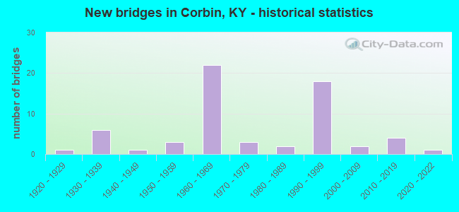
- New bridges - historical statistics
- 11920-1929
- 61930-1939
- 11940-1949
- 31950-1959
- 221960-1969
- 31970-1979
- 21980-1989
- 181990-1999
- 22000-2009
- 42010-2019
- 12020-2022


- Bridge Condition - Deck
- 4.8%Very good
- 40.5%Good
- 33.3%Satisfactory
- 19.0%Fair
- 2.4%Imminent failure

- Bridge Condition - Superstructure
- 14.3%Very good
- 31.0%Good
- 35.7%Satisfactory
- 9.5%Fair
- 7.1%Poor
- 2.4%Critical

- Bridge Condition - Substructure
- 11.9%Very good
- 40.5%Good
- 33.3%Satisfactory
- 11.9%Fair
- 2.4%Critical

- Bridge Condition - Channel
- 14.3%Very good
- 25.7%Good
- 40.0%Satisfactory
- 14.3%Fair
- 5.7%Poor

- Bridge Condition - Culverts
- 60.0%Satisfactory
- 40.0%Fair
Find on map >> Show street view
Structure Number: 118B00117N, Location: .2 MI.N JCT KY 312 (Lat: 36.950833, Lng: -84.095833), Route carried "on" structure: US 25, Year Built: 1997, Status: Open, Structure Length: 7.41m (24.31ft), Average Daily Traffic: 15,612 (year 2020), Truck Traffic: 7%, Average Future Daily Traffic: 14,519 (year 2040), Design Load: HS 25 or greater, Features Intersected: CSX RAILROAD
Minimum Vertical Clearance: 30+ m (98+ ft), Kilometerpoint: 53.796, Lanes on structure: 4, Lanes under structure: 1, Owner: State Highway Agency, Approaching Roadway Width: 20.1m (65.9ft), Skew: 1 degrees, Material/Design: Prestressed concrete continuous, Design/Construction: Stringer/Multi-beam, Number Of Spans In Main Unit: 3, Length of Maximum Span: 30.5m (100.1ft), Curb or Sidewalk Widths: Left: 1.5m (4.9ft), Right: 0.0m, Curb-To-Curb Width: 20.1m (65.9ft), Out-to-Out Width: 22.7m (74.5ft)
Condition: Deck: Good, Superstructure: Good, Substructure: Good, Operating Rating: 67.5 metric tons, Method Used To Determine Operating Rating: Load Factor (LF), Inventory Rating: 40.6 metric tons, Method Used To Determine Inventory Rating: Load Factor (LF), Structural Evaluation: Better than present minimum criteria, Deck Geometry: Better than present minimum criteria, Underclear: Equal to present minimum criteria, Approach Roadway Alignment: Equal to present minimum criteria, Designated Inspection Frequency: Every 24 months, Inspection Date: March 2021, Deck Structure Type: Concrete Cast-file-Place, Wearing Surface/Protective System: Wearing Surface: Monolithic Concrete, Deck Protection: Epoxy Coated Reinforcing
Find on map >> Show street view
Structure Number: 118B00121N, Location: WHITLEY-KNOX CO. LINE (Lat: 36.887222, Lng: -84.069722), Route carried "on" structure: State highway 6, Year Built: 2008, Status: Open, Structure Length: 1.95m (6.40ft), Average Daily Traffic: 1,221 (year 2019), Truck Traffic: 5%, Average Future Daily Traffic: 1,074 (year 2039), Design Load: HS 25 or greater, Features Intersected: CORN CREEK
Minimum Vertical Clearance: 30+ m (98+ ft), Kilometerpoint: 2.646, Lanes on structure: 2, Owner: State Highway Agency, Approaching Roadway Width: 9.1m (29.9ft), Material/Design: Steel, Design/Construction: Stringer/Multi-beam, Number Of Spans In Main Unit: 1, Length of Maximum Span: 17.7m (58.1ft), Curb-To-Curb Width: 9.1m (29.9ft), Out-to-Out Width: 10.1m (33.1ft)
Condition: Deck: Good, Superstructure: Good, Substructure: Good, Channel: Satisfactory, Operating Rating: 73.1 metric tons, Method Used To Determine Operating Rating: Load Factor (LF), Inventory Rating: 43.9 metric tons, Method Used To Determine Inventory Rating: Load Factor (LF), Structural Evaluation: Better than present minimum criteria, Deck Geometry: Somewhat better than minimum adequacy, Waterway Adequacy: Equal to present desirable criteria, Approach Roadway Alignment: Equal to present desirable criteria, Designated Inspection Frequency: Every 24 months, Inspection Date: March 2021, Deck Structure Type: Concrete Cast-file-Place, Wearing Surface/Protective System: Wearing Surface: Monolithic Concrete, Deck Protection: Epoxy Coated Reinforcing
Find on map >> Show street view
Structure Number: 118C00006N, Location: .2 MI E OF JCT KY 6 (Lat: 36.916667, Lng: -84.084722), Route carried "on" structure: County highway 1069, Year Built: 1936, Status: Closed, Structure Length: 1.68m (5.51ft), Average Daily Traffic: 50 (year 2006), Average Future Daily Traffic: 50 (year 2026), Features Intersected: LYNN CAMP CREEK, Facility Carried by Structure: HOWARD PERKINS ROA
Minimum Vertical Clearance: 30+ m (98+ ft), Kilometerpoint: 0.283, Lanes on structure: 1, Owner: County Highway Agency, Approaching Roadway Width: 3.7m (12.1ft), Material/Design: Steel, Design/Construction: Stringer/Multi-beam, Number Of Spans In Main Unit: 1, Number Of Approach Spans: 2, Length of Maximum Span: 7.9m (25.9ft), Curb-To-Curb Width: 3.3m (10.8ft), Out-to-Out Width: 3.7m (12.1ft)
Condition: Deck: Imminent failure, Superstructure: Critical, Substructure: Critical, Channel: Poor, Waterway Adequacy: Better than present minimum criteria, Approach Roadway Alignment: High priority of corrective action, Bridge Posting: Required (Relationship of Operating Rating to Maximum Legal Load: > 39.9% below), Length Of Structure Improvement: 0.17m (0.56ft), Designated Inspection Frequency: Every 12 months, Inspection Date: November 2021, Bridge Improvement Cost: $107,000, Total Project Cost: $106,000, Deck Structure Type: Wood or Timber, Wearing Surface/Protective System: Wearing Surface: Wood or Timber
Find on map >> Show street view
Structure Number: 118C00042N, Location: .05 MI E OF JCT US 25W (Lat: 36.954722, Lng: -84.094722), Route carried "on" structure: Other road 1040, Year Built: 1969, Status: Open, Structure Length: 1.95m (6.40ft), Average Daily Traffic: 300 (year 2006), Average Future Daily Traffic: 300 (year 2026), Design Load: H 20, Features Intersected: LYNN CAMP CREEK
Minimum Vertical Clearance: 30+ m (98+ ft), Kilometerpoint: 0.047, Lanes on structure: 1, Owner: County Highway Agency, Approaching Roadway Width: 4.9m (16.1ft), Material/Design: Prestressed concrete, Design/Construction: Box Beam or Girders - Multiple, Number Of Spans In Main Unit: 1, Length of Maximum Span: 18.3m (60.0ft), Curb or Sidewalk Widths: Left: 0.2m (0.7ft), Right: 0.2m (0.7ft), Curb-To-Curb Width: 4.1m (13.5ft), Out-to-Out Width: 4.7m (15.4ft)
Condition: Deck: Satisfactory, Superstructure: Poor, Substructure: Satisfactory, Channel: Satisfactory, Operating Rating: 84.1 metric tons, Method Used To Determine Operating Rating: Load Factor (LF), Inventory Rating: 50.4 metric tons, Method Used To Determine Inventory Rating: Load Factor (LF), Structural Evaluation: Meets minimum limits, Deck Geometry: High priority of replacement, Waterway Adequacy: Superior to present desirable criteria, Approach Roadway Alignment: Meets minimum limits, Length Of Structure Improvement: 0.20m (0.66ft), Designated Inspection Frequency: Every 24 months, Inspection Date: November 2021, Bridge Improvement Cost: $122,000, Total Project Cost: $121,000, Deck Structure Type: Concrete Precast Panels, Wearing Surface/Protective System: Wearing Surface: Bituminous, Deck Protection: Epoxy Coated Reinforcing
Find on map >> Show street view
Structure Number: 118C00044N, Location: .2 MI E OF JCT LAUREL AVE (Lat: 36.948889, Lng: -84.091111), Route carried "on" structure: City street 2028, Year Built: 1950, Status: Posted for load, Structure Length: 4.15m (13.62ft), Average Daily Traffic: 300 (year 2006), Average Future Daily Traffic: 2,026 (year 2026), Design Load: H 20, Features Intersected: LYNN CAMP CREEK, Facility Carried by Structure: B VILLE STREET
Minimum Vertical Clearance: 30+ m (98+ ft), Kilometerpoint: 0.288, Lanes on structure: 1, Owner: County Highway Agency, Approaching Roadway Width: 5.5m (18.0ft), Material/Design: Prestressed concrete, Design/Construction: Box Beam or Girders - Multiple, Number Of Spans In Main Unit: 3, Length of Maximum Span: 13.7m (44.9ft), Curb or Sidewalk Widths: Left: 1.2m (3.9ft), Right: 0.2m (0.7ft), Curb-To-Curb Width: 3.4m (11.2ft), Out-to-Out Width: 4.8m (15.7ft)
Condition: Deck: Fair, Superstructure: Poor, Substructure: Fair, Channel: Satisfactory, Operating Rating: 10.2 metric tons, Method Used To Determine Operating Rating: Load Factor (LF), Inventory Rating: 6.1 metric tons, Method Used To Determine Inventory Rating: Load Factor (LF), Structural Evaluation: High priority of corrective action, Deck Geometry: High priority of replacement, Waterway Adequacy: Equal to present desirable criteria, Approach Roadway Alignment: Equal to present minimum criteria, Bridge Posting: Required (Relationship of Operating Rating to Maximum Legal Load: > 39.9% below), Length Of Structure Improvement: 0.41m (1.35ft), Designated Inspection Frequency: Every 12 months, Inspection Date: November 2021, Bridge Improvement Cost: $267,000, Total Project Cost: $266,000, Deck Structure Type: Other, Wearing Surface/Protective System: Wearing Surface: Bituminous
Find on map >> Show street view
Structure Number: 118C00064N, Location: .2 MI S JCT US 25W (Lat: 36.916389, Lng: -84.117222), Route carried "on" structure: City street 2030, Year Built: 1998, Status: Posted for load, Structure Length: 0.94m (3.08ft), Average Daily Traffic: 1,479 (year 2018), Average Future Daily Traffic: 1,375 (year 2038), Design Load: HS 25 or greater, Features Intersected: BACON CREEK, Facility Carried by Structure: BACON CREEK ROAD
Minimum Vertical Clearance: 30+ m (98+ ft), Kilometerpoint: 0.274, Lanes on structure: 2, Owner: County Highway Agency, Approaching Roadway Width: 4.3m (14.1ft), Material/Design: Prestressed concrete, Design/Construction: Box Beam or Girders - Multiple, Number Of Spans In Main Unit: 1, Length of Maximum Span: 8.5m (27.9ft), Curb-To-Curb Width: 6.9m (22.6ft), Out-to-Out Width: 7.3m (24.0ft)
Condition: Deck: Good, Superstructure: Good, Substructure: Good, Channel: Good, Operating Rating: 54.0 metric tons, Method Used To Determine Operating Rating: Load Factor (LF), Inventory Rating: 32.4 metric tons, Method Used To Determine Inventory Rating: Load Factor (LF), Structural Evaluation: Better than present minimum criteria, Deck Geometry: High priority of corrective action, Waterway Adequacy: Better than present minimum criteria, Approach Roadway Alignment: Equal to present minimum criteria, Bridge Posting: Required (Relationship of Operating Rating to Maximum Legal Load: 0.1 - 9.9% below), Designated Inspection Frequency: Every 24 months, Inspection Date: November 2019, Deck Structure Type: Concrete Precast Panels, Wearing Surface/Protective System: Deck Protection: Epoxy Coated Reinforcing
Find on map >> Show street view
Structure Number: 118C00070N, Location: _ (Lat: 36.888594, Lng: -84.119433), Route carried "on" structure: County highway 1046, Year Built: 1985, Status: Posted for load, Structure Length: 2.96m (9.71ft), Average Daily Traffic: 220 (year 2017), Average Future Daily Traffic: 2,037 (year 2037), Features Intersected: Railroad
Minimum Vertical Clearance: 30+ m (98+ ft), Kilometerpoint: 0.027, Lanes on structure: 2, Owner: Railroad, Approaching Roadway Width: 7.8m (25.6ft), Material/Design: Prestressed concrete, Design/Construction: Box Beam or Girders - Multiple, Number Of Spans In Main Unit: 3, Length of Maximum Span: 14.3m (46.9ft), Curb or Sidewalk Widths: Left: 0.2m (0.7ft), Right: 0.2m (0.7ft), Curb-To-Curb Width: 7.8m (25.6ft), Out-to-Out Width: 8.2m (26.9ft)
Condition: Deck: Satisfactory, Superstructure: Poor, Substructure: Good, Operating Rating: 16.4 metric tons, Method Used To Determine Operating Rating: Field evaluation and documented engineering judgment, Inventory Rating: 16.3 metric tons, Method Used To Determine Inventory Rating: Field evaluation and documented engineering judgment, Structural Evaluation: Meets minimum limits, Deck Geometry: Somewhat better than minimum adequacy, Underclear: Equal to present minimum criteria, Approach Roadway Alignment: Meets minimum limits, Bridge Posting: Required (Relationship of Operating Rating to Maximum Legal Load: > 39.9% below), Designated Inspection Frequency: Every 12 months, Inspection Date: October 2021, Deck Structure Type: Concrete Precast Panels, Wearing Surface/Protective System: Wearing Surface: Epoxy Overlay, Deck Protection: Epoxy Coated Reinforcing
Find on map >> Show street view
Structure Number: 61B00095N, Location: .2 MI.S JCT US 25E (Lat: 36.943611, Lng: -84.051389), Route carried "under" structure: State highway 830, Year Built: 1993, Structure Length: 0. m, Average Daily Traffic: 1,655 (year 2020), Features Intersected: KY 1232,CSX RR,LYNN CAMP, Facility Carried by Structure: KY 3041
Minimum Vertical Clearance: 7.01m (23.00ft), Kilometerpoint: 6.107, Lanes on structure: 2, Lanes under structure: 2, Material/Design: Prestressed concrete continuous, Design/Construction: Stringer/Multi-beam, Length of Maximum Span: 30.5m (100.1ft)
Find on map >> Show street view
Structure Number: 118B00015N, Location: .50 MI W OF JCT KY 2384 (Lat: 36.945000, Lng: -84.123056), Route carried "under" structure: Interstate 75, Year Built: 1968, Structure Length: 0. m, Average Daily Traffic: 37,001 (year 2020), Truck Traffic: 28%, Features Intersected: I 75 @ 26.560, Facility Carried by Structure: OLD BARTON MILL RO
Minimum Vertical Clearance: 5.36m (17.59ft), Kilometerpoint: 42.736, Lanes on structure: 2, Lanes under structure: 4, Material/Design: Concrete continuous, Design/Construction: Tee Beam, Length of Maximum Span: 21.3m (69.9ft)
Find on map >> Show street view
Structure Number: 118B00048N, Location: 1.5 MI W OF JCT KY 26 (Lat: 36.895000, Lng: -84.142222), Route carried "under" structure: Interstate 75, Year Built: 1967, Structure Length: 0. m, Average Daily Traffic: 33,772 (year 2020), Truck Traffic: 28%, Features Intersected: I 75, Facility Carried by Structure: EATONTOWN SCHOOL R
Minimum Vertical Clearance: 6.32m (20.73ft), Kilometerpoint: 36.806, Lanes on structure: 2, Lanes under structure: 4, Material/Design: Concrete continuous, Design/Construction: Tee Beam, Length of Maximum Span: 30.5m (100.1ft)
Find on map >> Show street view
Structure Number: 118B00049N, Location: 1.1 MI S OF N-JCT US 25W (Lat: 36.902500, Lng: -84.134167), Route carried "under" structure: County highway 1065, Year Built: 1967, Structure Length: 0. m, Average Daily Traffic: 100 (year 2006), Features Intersected: BACON CRK-CORINTH RD, Facility Carried by Structure: I-75
Minimum Vertical Clearance: 3.96m (12.99ft), Kilometerpoint: 2.686, Lanes on structure: 4, Lanes under structure: 2, Material/Design: Concrete, Design/Construction: Culvert, Length of Maximum Span: 6.1m (20.0ft)
Find on map >> Show street view
Structure Number: 118B00050L, Location: SBL OVR N-NTRCH US 25W (Lat: 36.918056, Lng: -84.129722), Route carried "under" structure: US 25, Year Built: 1967, Structure Length: 0. m, Average Daily Traffic: 11,523 (year 2019), Truck Traffic: 7%, Features Intersected: US 25W, Facility Carried by Structure: I-75 NC
Minimum Vertical Clearance: 5.74m (18.83ft), Kilometerpoint: 47.656, Lanes on structure: 2, Lanes under structure: 3, Material/Design: Concrete continuous, Design/Construction: Tee Beam, Length of Maximum Span: 22.9m (75.1ft)
Find on map >> Show street view
Structure Number: 118B00050R, Location: NBL OVR N-NTRCH US 25W (Lat: 36.918056, Lng: -84.129444), Route carried "under" structure: US 25, Year Built: 1967, Structure Length: 0. m, Average Daily Traffic: 16,159 (year 2020), Truck Traffic: 7%, Features Intersected: US 25W, Facility Carried by Structure: I-75
Minimum Vertical Clearance: 5.99m (19.65ft), Kilometerpoint: 47.677, Lanes on structure: 2, Lanes under structure: 3, Material/Design: Concrete continuous, Design/Construction: Tee Beam, Length of Maximum Span: 22.9m (75.1ft)
Find on map >> Show street view
Structure Number: 118B00051L, Location: 1.25 MI N OF N-JCT US 25W (Lat: 36.935833, Lng: -84.125556), Route carried "under" structure: State highway 727, Year Built: 1968, Structure Length: 0. m, Average Daily Traffic: 2,196 (year 2020), Truck Traffic: 2%, Features Intersected: KY727-BARTON RD-WCL CORB, Facility Carried by Structure: I-75 NC
Minimum Vertical Clearance: 30+ m (98+ ft), Kilometerpoint: 4.307, Lanes on structure: 2, Lanes under structure: 2, Material/Design: Concrete continuous, Design/Construction: Tee Beam, Length of Maximum Span: 27.4m (89.9ft)
Find on map >> Show street view
Structure Number: 118B00051R, Location: 1.25 MI N OF N-JCT US 25W (Lat: 36.935833, Lng: -84.125278), Route carried "under" structure: State highway 727, Year Built: 1968, Structure Length: 0. m, Average Daily Traffic: 2,196 (year 2020), Truck Traffic: 2%, Features Intersected: KY 727-BARTON RD-WCL C, Facility Carried by Structure: I-75
Minimum Vertical Clearance: 30+ m (98+ ft), Kilometerpoint: 4.336, Lanes on structure: 2, Lanes under structure: 2, Material/Design: Concrete continuous, Design/Construction: Tee Beam, Length of Maximum Span: 24.4m (80.1ft)
Find on map >> Show street view
Structure Number: 118B00091N, Location: 1.2 MI W OF JCT US 25W (Lat: 36.957222, Lng: -84.118333), Route carried "under" structure: Interstate 75, Year Built: 1968, Structure Length: 0. m, Average Daily Traffic: 37,001 (year 2020), Truck Traffic: 28%, Features Intersected: I 75, Facility Carried by Structure: GORDON HILL PKE /
Minimum Vertical Clearance: 7.01m (23.00ft), Kilometerpoint: 44.156, Lanes on structure: 2, Lanes under structure: 4, Material/Design: Concrete continuous, Design/Construction: Tee Beam, Length of Maximum Span: 20.7m (67.9ft)
Find on map >> Show street view
Structure Number: 118B00112N, Location: 1.65 MI E JCT US 25W (Lat: 36.916389, Lng: -84.086944), Route carried "under" structure: State highway 26, Year Built: 1996, Structure Length: 0. m, Average Daily Traffic: 4,794 (year 2020), Truck Traffic: 7%, Features Intersected: KY 26 & CSX RAILROAD, Facility Carried by Structure: KY-3041
Minimum Vertical Clearance: 30+ m (98+ ft), Kilometerpoint: 21.061, Lanes on structure: 2, Lanes under structure: 2, Material/Design: Prestressed concrete continuous, Design/Construction: Stringer/Multi-beam, Length of Maximum Span: 30.5m (100.1ft)
Find on map >> Show street view
Structure Number: 118B00113N, Location: 1.8 MI E. JCT 25W (Lat: 36.916111, Lng: -84.084167), Route carried "under" structure: County highway 1069, Year Built: 1996, Structure Length: 0. m, Features Intersected: LYNN CAMP CREEK, Facility Carried by Structure: KY 3041
Minimum Vertical Clearance: 5.18m (16.99ft), Kilometerpoint: 0.224, Lanes on structure: 2, Lanes under structure: 2, Material/Design: Prestressed concrete continuous, Design/Construction: Stringer/Multi-beam, Length of Maximum Span: 30.5m (100.1ft)
Find on map >> Show street view
Structure Number: 118B00113N, Location: 1.8 MI E. JCT 25W (Lat: 36.916111, Lng: -84.084167), Route carried "under" structure: County highway 1471, Year Built: 1996, Structure Length: 0. m, Features Intersected: LYNN CAMP CREEK, Facility Carried by Structure: KY 3041
Minimum Vertical Clearance: 5.33m (17.49ft), Kilometerpoint: 0.262, Lanes on structure: 2, Lanes under structure: 2, Material/Design: Prestressed concrete continuous, Design/Construction: Stringer/Multi-beam, Length of Maximum Span: 30.5m (100.1ft)
Find on map >> Show street view
Structure Number: 118B00116N, Location: .05 MI.W JCT KNOX CO LN (Lat: 36.951111, Lng: -84.094722), Route carried "under" structure: City street 2126, Year Built: 1997, Structure Length: 0. m, Average Daily Traffic: 6,000 (year 2006), Features Intersected: LAUREL AVENUE, Facility Carried by Structure: MASTER STREET
Minimum Vertical Clearance: 30+ m (98+ ft), Kilometerpoint: 0.198, Lanes on structure: 4, Lanes under structure: 2, Material/Design: Prestressed concrete, Design/Construction: Stringer/Multi-beam, Length of Maximum Span: 19.8m (65.0ft)
Find on map >> Show street view
Structure Number: 118B00117N, Location: .2 MI.N JCT KY 312 (Lat: 36.950833, Lng: -84.095833), Route carried "under" structure: City street 2212, Year Built: 1997, Structure Length: 0. m, Average Daily Traffic: 19,853 (year 2006), Features Intersected: CSX RAILROAD, Facility Carried by Structure: US25W
Minimum Vertical Clearance: 30+ m (98+ ft), Kilometerpoint: 0.859, Lanes on structure: 4, Lanes under structure: 1, Material/Design: Prestressed concrete continuous, Design/Construction: Stringer/Multi-beam, Length of Maximum Span: 30.5m (100.1ft)
Find on map >> Show street view
Structure Number: 118R00601N, Location: 3.0 MI S.W. OF JCT KY 6 (Lat: 36.877500, Lng: -84.132500), Route carried "under" structure: State highway 26, Year Built: 1930, Structure Length: 0. m, Average Daily Traffic: 2,196 (year 2019), Truck Traffic: 8%, Features Intersected: CSX RR OVER KY 26
Minimum Vertical Clearance: 3.66m (12.01ft), Kilometerpoint: 14.555, Lanes under structure: 2, Material/Design: Concrete, Design/Construction: Culvert, Length of Maximum Span: 24.4m (80.1ft)
Find on map >> Show street view
Structure Number: 118R00602N, Location: .05 MI NE OF S-JCT KY 312 (Lat: 36.949722, Lng: -84.095833), Route carried "under" structure: City street 2167, Year Built: 1934, Structure Length: 0. m, Average Daily Traffic: 23,140 (year 2006), Features Intersected: CSX RR OVER OLD US 25W, Facility Carried by Structure: ROY KIDD AVENUE
Minimum Vertical Clearance: 3.69m (12.11ft), Kilometerpoint: 0.113, Lanes under structure: 2, Material/Design: Concrete, Design/Construction: Box Beam or Girders - Multiple, Length of Maximum Span: 9.1m (29.9ft)