Bridge Statistics for Danville, Illinois (IL)
Condition, Traffic, Stress, Structural Evaluation, Project Costs
- National Bridge Inventory (NBI) Statistics
- 109Number of bridges
- 1,342ft / 409mTotal length
- $5,187,000Total costs
- 605,945Total average daily traffic
- 128,405Total average daily truck traffic
- National Bridge Inventory (NBI) Registered Bridges for Danville
- No street view available for this location
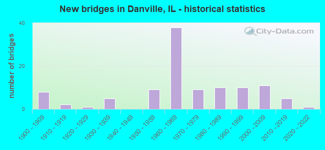
- New bridges - historical statistics
- 81900-1909
- 21910-1919
- 11920-1929
- 51930-1939
- 91950-1959
- 381960-1969
- 91970-1979
- 101980-1989
- 101990-1999
- 112000-2009
- 52010-2019
- 12020-2022

- Reconstructed bridges - Historical Statistics
- 31970-1979
- 111980-1989
- 11990-1999


- Bridge Condition - Deck
- 3.2%Excellent
- 7.9%Very good
- 15.9%Good
- 57.1%Satisfactory
- 4.8%Fair
- 7.9%Poor
- 3.2%Serious

- Bridge Condition - Superstructure
- 3.1%Excellent
- 14.1%Very good
- 23.4%Good
- 39.1%Satisfactory
- 12.5%Fair
- 6.3%Poor
- 1.6%Serious

- Bridge Condition - Substructure
- 3.1%Excellent
- 21.9%Very good
- 48.4%Good
- 12.5%Satisfactory
- 10.9%Fair
- 1.6%Poor
- 1.6%Serious

- Bridge Condition - Channel
- 23.2%Very good
- 39.3%Good
- 23.2%Satisfactory
- 14.3%Fair

- Bridge Condition - Culverts
- 8.3%Very good
- 33.3%Good
- 41.7%Satisfactory
- 16.7%Fair
Find on map >> Show street view
Structure Number: 920023, Location: W OF LYNCH SPUR (Lat: 40.116581, Lng: -87.541872), Route carried "under" structure: City street , Year Built: 1964, Structure Length: 0. m, Average Daily Traffic: 125 (year 2019), Truck Traffic: 24%, Features Intersected: CSX RR & MS 9010, Facility Carried by Structure: I-74(WB)&RAMP21.70
Minimum Vertical Clearance: 7.01m (23.00ft), Kilometerpoint: 0.274, Lanes on structure: 4, Lanes under structure: 2, Material/Design: Steel continuous, Design/Construction: Stringer/Multi-beam, Length of Maximum Span: 30.2m (99.1ft)
Find on map >> Show street view
Structure Number: 920024, Location: W OF LYNCH SPUR (Lat: 40.116378, Lng: -87.541608), Route carried "under" structure: City street , Year Built: 1964, Structure Length: 0. m, Average Daily Traffic: 125 (year 2019), Truck Traffic: 24%, Features Intersected: CSX RR & MS 9010, Facility Carried by Structure: I-74(EB)
Minimum Vertical Clearance: 7.14m (23.43ft), Kilometerpoint: 0.306, Lanes on structure: 2, Lanes under structure: 2, Material/Design: Steel continuous, Design/Construction: Stringer/Multi-beam, Length of Maximum Span: 30.2m (99.1ft)
Find on map >> Show street view
Structure Number: 920025, Location: E OF DANVILLE (Lat: 40.117292, Lng: -87.538003), Route carried "under" structure: Other road , Year Built: 1961, Structure Length: 0. m, Average Daily Traffic: 3,250 (year 2020), Truck Traffic: 21%, Features Intersected: LYNCH RD., Facility Carried by Structure: I-74 (WB)
Minimum Vertical Clearance: 4.47m (14.67ft), Kilometerpoint: 16.029, Lanes on structure: 2, Lanes under structure: 2, Material/Design: Steel continuous, Design/Construction: Stringer/Multi-beam, Length of Maximum Span: 18.9m (62.0ft)
Find on map >> Show street view
Structure Number: 920026, Location: E OF DANVILLE (Lat: 40.117122, Lng: -87.537742), Route carried "under" structure: Other road , Year Built: 1961, Structure Length: 0. m, Average Daily Traffic: 3,250 (year 2020), Truck Traffic: 21%, Features Intersected: LYNCH RD., Facility Carried by Structure: I-74 EB & RAMP 21.
Minimum Vertical Clearance: 4.60m (15.09ft), Kilometerpoint: 0.016, Lanes on structure: 3, Lanes under structure: 2, Material/Design: Steel continuous, Design/Construction: Stringer/Multi-beam, Length of Maximum Span: 18.9m (62.0ft)
Find on map >> Show street view
Structure Number: 920027, Location: E OF DANVILLE (Lat: 40.114975, Lng: -87.611411), Route carried "under" structure: City street , Year Built: 1964, Structure Length: 0. m, Average Daily Traffic: 250 (year 2019), Truck Traffic: 4%, Features Intersected: TEXAS AVE, Facility Carried by Structure: BOWMAN AVE(FAU 704
Minimum Vertical Clearance: 4.62m (15.16ft), Kilometerpoint: 0.338, Lanes on structure: 4, Lanes under structure: 2, Material/Design: Steel, Design/Construction: Stringer/Multi-beam, Length of Maximum Span: 12.2m (40.0ft)
Find on map >> Show street view
Structure Number: 920052, Location: W EDGE DANVILLE (Lat: 40.124253, Lng: -87.645536), Route carried "under" structure: US 150, Year Built: 1950, Structure Length: 0. m, Average Daily Traffic: 12,800 (year 2021), Truck Traffic: 8%, Features Intersected: US 150(FAP 729), Facility Carried by Structure: CNRL RR
Minimum Vertical Clearance: 4.29m (14.07ft), Kilometerpoint: 352.211, Lanes under structure: 4, Material/Design: Steel, Design/Construction: Box Beam or Girders - Multiple, Length of Maximum Span: 21.9m (71.9ft)
Find on map >> Show street view
Structure Number: 920053, Location: IN DANVILLE (Lat: 40.124375, Lng: -87.639544), Route carried "under" structure: County highway , Year Built: 1950, Structure Length: 0. m, Average Daily Traffic: 250 (year 2019), Truck Traffic: 6%, Features Intersected: N FORK VERMILION RIV, Facility Carried by Structure: US 150(FAP 729)
Minimum Vertical Clearance: 7.62m (25.00ft), Kilometerpoint: 0.322, Lanes on structure: 4, Lanes under structure: 2, Material/Design: Prestressed concrete continuous, Design/Construction: Stringer/Multi-beam, Length of Maximum Span: 39.6m (129.9ft)
Find on map >> Show street view
Structure Number: 920053, Location: IN DANVILLE (Lat: 40.124394, Lng: -87.638519), Route carried "under" structure: County highway , Year Built: 1950, Structure Length: 0. m, Average Daily Traffic: 50 (year 2019), Truck Traffic: 12%, Features Intersected: N FORK VERMILION RIV, Facility Carried by Structure: US 150(FAP 729)
Minimum Vertical Clearance: 7.62m (25.00ft), Kilometerpoint: 0.483, Lanes on structure: 4, Lanes under structure: 2, Material/Design: Prestressed concrete continuous, Design/Construction: Stringer/Multi-beam, Length of Maximum Span: 39.6m (129.9ft)
Find on map >> Show street view
Structure Number: 920056, Location: 0.5 MI E OF DANVILLE (Lat: 40.133519, Lng: -87.563531), Route carried "under" structure: US 136, Year Built: 1934, Structure Length: 0. m, Average Daily Traffic: 6,200 (year 2021), Truck Traffic: 9%, Features Intersected: US 136(FAP 729), Facility Carried by Structure: CSX RR
Minimum Vertical Clearance: 4.32m (14.17ft), Kilometerpoint: 361.159, Lanes under structure: 2, Material/Design: Steel, Design/Construction: Girder and Floorbeam System, Length of Maximum Span: 15.2m (49.9ft)
Find on map >> Show street view
Structure Number: 920057, Location: IN DANVILLE (Lat: 40.124250, Lng: -87.646219), Route carried "under" structure: US 150, Year Built: 1950, Structure Length: 0. m, Average Daily Traffic: 12,800 (year 2021), Truck Traffic: 8%, Features Intersected: US 150(FAP 729), Facility Carried by Structure: "A" AVE (MS 6480)
Minimum Vertical Clearance: 4.62m (15.16ft), Kilometerpoint: 352.163, Lanes on structure: 2, Lanes under structure: 4, Material/Design: Steel, Design/Construction: Stringer/Multi-beam, Length of Maximum Span: 21.7m (71.2ft)
Find on map >> Show street view
Structure Number: 920084, Location: IN DANVILLE (Lat: 40.112511, Lng: -87.612931), Route carried "under" structure: Other road , Year Built: 1962, Structure Length: 0. m, Average Daily Traffic: 3,550 (year 2021), Truck Traffic: 9%, Features Intersected: I-74&RMPS17.79/17.87, Facility Carried by Structure: FAU 7043(PERRYSVIL
Minimum Vertical Clearance: 5.03m (16.50ft), Kilometerpoint: 0.241, Lanes on structure: 2, Lanes under structure: 1, Material/Design: Steel continuous, Design/Construction: Stringer/Multi-beam, Length of Maximum Span: 26.3m (86.3ft)
Find on map >> Show street view
Structure Number: 920084, Location: IN DANVILLE (Lat: 40.112881, Lng: -87.613319), Route carried "under" structure: Other road , Year Built: 1962, Structure Length: 0. m, Average Daily Traffic: 3,550 (year 2021), Truck Traffic: 9%, Features Intersected: I-74&RMPS17.79/17.87, Facility Carried by Structure: FAU 7043(PERRYSVIL
Minimum Vertical Clearance: 5.03m (16.50ft), Kilometerpoint: 0.290, Lanes on structure: 2, Lanes under structure: 1, Material/Design: Steel continuous, Design/Construction: Stringer/Multi-beam, Length of Maximum Span: 26.3m (86.3ft)
Find on map >> Show street view
Structure Number: 920084, Location: IN DANVILLE (Lat: 40.112689, Lng: -87.613131), Route carried "under" structure: Interstate 74, Year Built: 1962, Structure Length: 0. m, Average Daily Traffic: 27,200 (year 2021), Truck Traffic: 30%, Features Intersected: I-74&RMPS17.79/17.87, Facility Carried by Structure: FAU 7043(PERRYSVIL
Minimum Vertical Clearance: 5.03m (16.50ft), Kilometerpoint: 350.087, Lanes on structure: 2, Lanes under structure: 4, Material/Design: Steel continuous, Design/Construction: Stringer/Multi-beam, Length of Maximum Span: 26.3m (86.3ft)
Find on map >> Show street view
Structure Number: 920126, Location: S OF HILLERY (Lat: 40.117208, Lng: -87.697731), Route carried "under" structure: Interstate 74, Year Built: 1962, Structure Length: 0. m, Average Daily Traffic: 21,200 (year 2021), Truck Traffic: 38%, Features Intersected: I-74, Facility Carried by Structure: TR 250
Minimum Vertical Clearance: 5.49m (18.01ft), Kilometerpoint: 342.185, Lanes on structure: 2, Lanes under structure: 4, Material/Design: Concrete continuous, Design/Construction: Tee Beam, Length of Maximum Span: 20.9m (68.6ft)
Find on map >> Show street view
Structure Number: 920129, Location: S OF DANVILLE (Lat: 40.107550, Lng: -87.621728), Route carried "under" structure: Interstate 74, Year Built: 1962, Structure Length: 0. m, Average Daily Traffic: 27,200 (year 2021), Truck Traffic: 30%, Features Intersected: I-74, Facility Carried by Structure: FAU 7019(TR 354)
Minimum Vertical Clearance: 6.30m (20.67ft), Kilometerpoint: 349.170, Lanes on structure: 2, Lanes under structure: 4, Material/Design: Concrete continuous, Design/Construction: Tee Beam, Length of Maximum Span: 21.0m (68.9ft)
Find on map >> Show street view
Structure Number: 920151, Location: SE OF DANVILLE (Lat: 40.115239, Lng: -87.563931), Route carried "under" structure: Interstate 74, Year Built: 1962, Structure Length: 0. m, Average Daily Traffic: 21,100 (year 2021), Truck Traffic: 38%, Features Intersected: I-74, Facility Carried by Structure: CH 28 (BREWER RD)
Minimum Vertical Clearance: 5.21m (17.09ft), Kilometerpoint: 354.320, Lanes on structure: 2, Lanes under structure: 4, Material/Design: Concrete continuous, Design/Construction: Tee Beam, Length of Maximum Span: 16.9m (55.4ft)
Find on map >> Show street view
Structure Number: 920154, Location: IN DANVILLE (Lat: 40.147069, Lng: -87.576072), Route carried "under" structure: Other road , Year Built: 1963, Structure Length: 0. m, Average Daily Traffic: 3,200 (year 2019), Truck Traffic: 11%, Features Intersected: CH 34(VOORHEES), Facility Carried by Structure: KBS RR
Minimum Vertical Clearance: 4.57m (14.99ft), Kilometerpoint: 5.890, Lanes under structure: 2, Material/Design: Steel, Design/Construction: Stringer/Multi-beam, Length of Maximum Span: 16.8m (55.1ft)
Find on map >> Show street view
Structure Number: 920198, Location: S OF DANVILLE (Lat: 40.113678, Lng: -87.610250), Route carried "under" structure: Interstate 74, Year Built: 1993, Structure Length: 0. m, Average Daily Traffic: 21,100 (year 2021), Truck Traffic: 38%, Features Intersected: I-74 & RAMP 18.32, Facility Carried by Structure: FAU 7045(BOWMAN AV
Minimum Vertical Clearance: 5.31m (17.42ft), Kilometerpoint: 350.361, Lanes on structure: 2, Lanes under structure: 4, Material/Design: Steel continuous, Design/Construction: Stringer/Multi-beam, Length of Maximum Span: 29.6m (97.1ft)
Find on map >> Show street view
Structure Number: 920198, Location: S OF DANVILLE (Lat: 40.113181, Lng: -87.611561), Route carried "under" structure: Other road , Year Built: 1993, Structure Length: 0. m, Average Daily Traffic: 500 (year 2021), Truck Traffic: 20%, Features Intersected: I-74 & RAMP 18.32, Facility Carried by Structure: FAU 7045(BOWMAN AV
Minimum Vertical Clearance: 4.95m (16.24ft), Kilometerpoint: 0.322, Lanes on structure: 2, Lanes under structure: 4, Material/Design: Steel continuous, Design/Construction: Stringer/Multi-beam, Length of Maximum Span: 29.6m (97.1ft)
Find on map >> Show street view
Structure Number: 923001, Location: 3.0 MI NE DANVILLE (Lat: 40.190761, Lng: -87.582369), Route carried "under" structure: County highway , Year Built: 1900, Structure Length: 0. m, Average Daily Traffic: 425 (year 2019), Truck Traffic: 4%, Features Intersected: POLAND RD(FAS 501), Facility Carried by Structure: KBS RR
Minimum Vertical Clearance: 3.05m (10.01ft), Kilometerpoint: 0.145, Lanes under structure: 2, Material/Design: Concrete, Design/Construction: Arch - Deck, Length of Maximum Span: 5.2m (17.1ft)
Find on map >> Show street view
Structure Number: 92316, Location: E DANVILLE WINTER AV (Lat: 40.161411, Lng: -87.583975), Route carried "under" structure: Other road , Year Built: 1900, Structure Length: 0. m, Average Daily Traffic: 4,100 (year 2019), Truck Traffic: 2%, Features Intersected: FAU 6998, Facility Carried by Structure: N&S & KDS RR
Minimum Vertical Clearance: 3.71m (12.17ft), Kilometerpoint: 10.444, Lanes under structure: 2, Material/Design: Steel, Design/Construction: Girder and Floorbeam System, Length of Maximum Span: 18.6m (61.0ft)
Find on map >> Show street view
Structure Number: 926001, Location: IN DANVILLE (Lat: 40.139011, Lng: -87.613636), Route carried "under" structure: Other road , Year Built: 1915, Structure Length: 0. m, Average Daily Traffic: 6,300 (year 2019), Truck Traffic: 7%, Features Intersected: FAIRCHILD(FAU 7002), Facility Carried by Structure: CSX & N&S RR
Minimum Vertical Clearance: 4.75m (15.58ft), Kilometerpoint: 1.352, Lanes under structure: 2, Material/Design: Masonry, Design/Construction: Arch - Thru, Length of Maximum Span: 11.3m (37.1ft)
Find on map >> Show street view
Structure Number: 926002, Location: IN DANVILLE (Lat: 40.138983, Lng: -87.616031), Route carried "under" structure: Other road , Year Built: 1915, Structure Length: 0. m, Average Daily Traffic: 6,300 (year 2019), Truck Traffic: 7%, Features Intersected: FAIRCHILD(FAU 7002), Facility Carried by Structure: N&S RR
Minimum Vertical Clearance: 4.75m (15.58ft), Kilometerpoint: 1.207, Lanes under structure: 2, Material/Design: Masonry, Design/Construction: Arch - Thru, Length of Maximum Span: 11.3m (37.1ft)
Find on map >> Show street view
Structure Number: 926004, Location: AT DANVILLE HIGH S (Lat: 40.138817, Lng: -87.623175), Route carried "under" structure: Other road , Year Built: 1905, Structure Length: 0. m, Average Daily Traffic: 6,650 (year 2019), Truck Traffic: 6%, Features Intersected: FAIRCHILD(FAU 7002), Facility Carried by Structure: CNRL RR
Minimum Vertical Clearance: 4.24m (13.91ft), Kilometerpoint: 0.612, Lanes under structure: 4, Material/Design: Steel, Length of Maximum Span: 27.4m (89.9ft)
Find on map >> Show street view
Structure Number: 926005, Location: 0.75 MI W OF IL 1 (Lat: 40.124081, Lng: -87.649747), Route carried "under" structure: US 150, Year Built: 1973, Structure Length: 0. m, Average Daily Traffic: 12,800 (year 2021), Truck Traffic: 8%, Features Intersected: US 150(FAP 729), Facility Carried by Structure: PEDESTRIAN BRIDGE
Minimum Vertical Clearance: 5.26m (17.26ft), Kilometerpoint: 351.873, Lanes under structure: 4, Material/Design: Steel, Design/Construction: Stringer/Multi-beam, Length of Maximum Span: 15.5m (50.9ft)
Find on map >> Show street view
Structure Number: 926021, Location: DANVILLE (Lat: 40.130336, Lng: -87.621772), Route carried "under" structure: Other road , Year Built: 1900, Structure Length: 0. m, Average Daily Traffic: 3,550 (year 2019), Truck Traffic: 8%, Features Intersected: SEMINARY (FAU 7004), Facility Carried by Structure: CNRL RR
Minimum Vertical Clearance: 4.39m (14.40ft), Kilometerpoint: 1.159, Lanes under structure: 2, Material/Design: Steel, Design/Construction: Box Beam or Girders - Multiple, Length of Maximum Span: 17.1m (56.1ft)
Find on map >> Show street view
Structure Number: 926039, Location: 2.2 MI SW AIRPORT (Lat: 40.188967, Lng: -87.659367), Route carried "under" structure: Other road , Year Built: 2009, Structure Length: 0. m, Average Daily Traffic: 1,000 (year 2019), Truck Traffic: 14%, Features Intersected: WINTER AVENUE, Facility Carried by Structure: CSX RR
Minimum Vertical Clearance: 5.38m (17.65ft), Kilometerpoint: 1.802, Lanes under structure: 2, Material/Design: Steel, Design/Construction: Stringer/Multi-beam, Length of Maximum Span: 17.6m (57.7ft)
Find on map >> Show street view
Structure Number: 929902, Location: .5 MI NE VERM AIRPOR (Lat: 40.205392, Lng: -87.582733), Route carried "under" structure: County highway , Year Built: 1900, Structure Length: 0. m, Average Daily Traffic: 50 (year 2019), Truck Traffic: 4%, Features Intersected: TR 181 A, Facility Carried by Structure: KBSR RR
Minimum Vertical Clearance: 4.29m (14.07ft), Kilometerpoint: 0.531, Lanes under structure: 2, Material/Design: Concrete, Design/Construction: Arch - Deck, Length of Maximum Span: 7.3m (24.0ft)
Find on map >> Show street view
Structure Number: 929907, Location: N EDGE OF DANVILLE (Lat: 40.183208, Lng: -87.619078), Route carried "under" structure: Other road , Year Built: 1925, Structure Length: 0. m, Average Daily Traffic: 1,200 (year 2019), Truck Traffic: 3%, Features Intersected: FAS 501(POLAND RD), Facility Carried by Structure: CSX RR
Minimum Vertical Clearance: 4.27m (14.01ft), Kilometerpoint: 0.933, Lanes under structure: 2, Material/Design: Steel, Design/Construction: Girder and Floorbeam System, Length of Maximum Span: 17.4m (57.1ft)
Find on map >> Show street view
Structure Number: 929916, Location: SE COR SPRHILL CEM (Lat: 40.142478, Lng: -87.620972), Route carried "under" structure: City street , Year Built: 1900, Structure Length: 0. m, Average Daily Traffic: 150 (year 2019), Truck Traffic: 3%, Features Intersected: ENGLISH ST(MS 1850), Facility Carried by Structure: CNRL RR
Minimum Vertical Clearance: 3.23m (10.60ft), Kilometerpoint: 0.579, Lanes under structure: 2, Material/Design: Steel, Design/Construction: Girder and Floorbeam System, Length of Maximum Span: 23.5m (77.1ft)