Bridge Statistics for Del City, Oklahoma (OK)
Condition, Traffic, Stress, Structural Evaluation, Project Costs
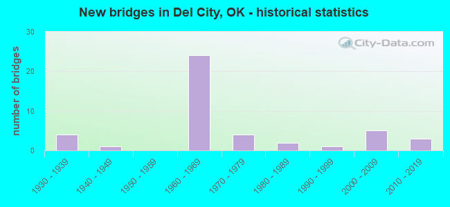
- New bridges - historical statistics
- 41930-1939
- 11940-1949
- 241960-1969
- 41970-1979
- 21980-1989
- 11990-1999
- 52000-2009
- 32010-2019

- Reconstructed bridges - Historical Statistics
- 11960-1969
- 41970-1979
- 01980-1989
- 21990-1999
- 02000-2009
- 22010-2019


- Bridge Condition - Deck
- 12.5%Very good
- 45.8%Good
- 16.7%Satisfactory
- 12.5%Fair
- 8.3%Poor
- 4.2%Serious

- Bridge Condition - Superstructure
- 4.2%Excellent
- 16.7%Very good
- 29.2%Good
- 16.7%Satisfactory
- 25.0%Fair
- 8.3%Poor

- Bridge Condition - Substructure
- 12.5%Very good
- 29.2%Good
- 12.5%Satisfactory
- 20.8%Fair
- 25.0%Poor

- Bridge Condition - Channel
- 35.5%Very good
- 25.8%Good
- 25.8%Satisfactory
- 12.9%Fair

- Bridge Condition - Culverts
- 93.3%Satisfactory
- 6.7%Fair
Find on map >> Show street view
Structure Number: 15085, Location: 1.9 MI E OF JCT I35 (Lat: 35.455069, Lng: -97.441742), Route carried "under" structure: City street , Year Built: 1960, Structure Length: 0. m, Average Daily Traffic: 5,000 (year 2020), Truck Traffic: 5%, Features Intersected: SUNNYLANE UNDER, Facility Carried by Structure: I-40 WB
Minimum Vertical Clearance: 5.18m (16.99ft), Kilometerpoint: 2.927, Lanes on structure: 3, Lanes under structure: 3, Material/Design: Concrete continuous, Design/Construction: Slab, Length of Maximum Span: 19.2m (63.0ft)
Find on map >> Show street view
Structure Number: 15086, Location: 1.9 MI E OF JCT I35 (Lat: 35.454750, Lng: -97.441739), Route carried "under" structure: City street , Year Built: 1960, Structure Length: 0. m, Average Daily Traffic: 5,000 (year 2020), Truck Traffic: 5%, Features Intersected: SUNNYLANE UNDER, Facility Carried by Structure: I-40 EB
Minimum Vertical Clearance: 5.18m (16.99ft), Kilometerpoint: 2.927, Lanes on structure: 3, Lanes under structure: 4, Material/Design: Concrete continuous, Design/Construction: Slab, Length of Maximum Span: 19.2m (63.0ft)
Find on map >> Show street view
Structure Number: 15111, Location: 3.1 MI E OF JCT I35 (Lat: 35.445236, Lng: -97.423833), Route carried "under" structure: City street 9481, Year Built: 1960, Structure Length: 0. m, Average Daily Traffic: 5,000 (year 2020), Truck Traffic: 5%, Features Intersected: FAU 9481 (SOONER RD) UND, Facility Carried by Structure: I-40 EB
Minimum Vertical Clearance: 4.67m (15.32ft), Kilometerpoint: 4.859, Lanes on structure: 2, Lanes under structure: 5, Material/Design: Steel continuous, Design/Construction: Stringer/Multi-beam, Length of Maximum Span: 21.6m (70.9ft)
Find on map >> Show street view
Structure Number: 15141, Location: 1.1 MI E OF JCT I35 (Lat: 35.458275, Lng: -97.455989), Route carried "under" structure: Interstate 40, Year Built: 1960, Structure Length: 0. m, Average Daily Traffic: 86,200 (year 2020), Truck Traffic: 12%, Features Intersected: I-40 UNDER, Facility Carried by Structure: SCOTT ST.
Minimum Vertical Clearance: 5.11m (16.77ft), Kilometerpoint: 1.865, Lanes on structure: 2, Lanes under structure: 6, Material/Design: Concrete continuous, Design/Construction: Slab, Length of Maximum Span: 16.8m (55.1ft)
Find on map >> Show street view
Structure Number: 15179, Location: 2.6 MI E OF JCT I35 (Lat: 35.449858, Lng: -97.432292), Route carried "under" structure: City street 9440, Year Built: 1960, Structure Length: 0. m, Average Daily Traffic: 5,000 (year 2020), Truck Traffic: 5%, Features Intersected: FAU 9440 (SE 15 ST) UND, Facility Carried by Structure: I-40 EB
Minimum Vertical Clearance: 4.57m (14.99ft), Kilometerpoint: 3.941, Lanes on structure: 3, Lanes under structure: 4, Material/Design: Steel continuous, Design/Construction: Stringer/Multi-beam, Length of Maximum Span: 33.5m (109.9ft)