Bridge Statistics for Dyersville, Iowa (IA)
Condition, Traffic, Stress, Structural Evaluation, Project Costs
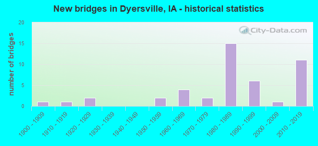
- New bridges - historical statistics
- 11900-1909
- 11910-1919
- 21920-1929
- 21950-1959
- 41960-1969
- 21970-1979
- 151980-1989
- 61990-1999
- 12000-2009
- 112010-2019


- Bridge Condition - Deck
- 18.2%Very good
- 36.4%Good
- 15.2%Satisfactory
- 27.3%Fair
- 3.0%Poor

- Bridge Condition - Superstructure
- 32.4%Very good
- 23.5%Good
- 17.6%Satisfactory
- 23.5%Fair
- 2.9%Poor

- Bridge Condition - Substructure
- 23.5%Very good
- 29.4%Good
- 20.6%Satisfactory
- 20.6%Fair
- 5.9%Poor

- Bridge Condition - Channel
- 20.5%Very good
- 25.6%Good
- 46.2%Satisfactory
- 7.7%Fair

- Bridge Condition - Culverts
- 37.5%Good
- 62.5%Satisfactory
Find on map >> Show street view
Structure Number: 605735, Location: AT JCT. IA 136 (Lat: 42.468775, Lng: -91.114678), Route carried "under" structure: US 52, Year Built: 1987, Structure Length: 0. m, Average Daily Traffic: 3,150 (year 2020), Truck Traffic: 10%, Features Intersected: US 52 SB, Facility Carried by Structure: EB US 20
Minimum Vertical Clearance: 30+ m (98+ ft), Kilometerpoint: 164.638, Lanes on structure: 3, Lanes under structure: 2, Material/Design: Prestressed concrete, Design/Construction: Stringer/Multi-beam, Length of Maximum Span: 28.0m (91.9ft)
Find on map >> Show street view
Structure Number: 60574, Location: AT JCT. IA 136 (Lat: 42.469003, Lng: -91.113961), Route carried "under" structure: US 52, Year Built: 1987, Structure Length: 0. m, Average Daily Traffic: 3,150 (year 2020), Truck Traffic: 10%, Features Intersected: US 52 SB, Facility Carried by Structure: WB US 20
Minimum Vertical Clearance: 30+ m (98+ ft), Kilometerpoint: 164.612, Lanes on structure: 3, Lanes under structure: 3, Material/Design: Prestressed concrete, Design/Construction: Stringer/Multi-beam, Length of Maximum Span: 28.0m (91.9ft)
Find on map >> Show street view
Structure Number: 70037, Location: 1.6 Mi. W of IA 136 (Lat: 42.470856, Lng: -91.146722), Route carried "under" structure: US 20, Year Built: 2016, Structure Length: 0. m, Average Daily Traffic: 8,300 (year 2020), Truck Traffic: 21%, Features Intersected: US 20, Facility Carried by Structure: 330TH-332ND AVE
Minimum Vertical Clearance: 30+ m (98+ ft), Kilometerpoint: 438.459, Lanes on structure: 3, Lanes under structure: 4, Material/Design: Prestressed concrete, Design/Construction: Stringer/Multi-beam, Length of Maximum Span: 38.4m (126.0ft)