Bridge Statistics for Galesburg, Illinois (IL)
Condition, Traffic, Stress, Structural Evaluation, Project Costs
- National Bridge Inventory (NBI) Statistics
- 105Number of bridges
- 1,191ft / 363mTotal length
- $6,841,000Total costs
- 558,535Total average daily traffic
- 88,886Total average daily truck traffic
- National Bridge Inventory (NBI) Registered Bridges for Galesburg
- No street view available for this location
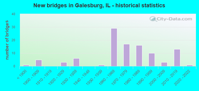
- New bridges - historical statistics
- 1Before 1900
- 51900-1909
- 31920-1929
- 61930-1939
- 11950-1959
- 291960-1969
- 171970-1979
- 161980-1989
- 101990-1999
- 32000-2009
- 132010-2019
- 12020-2022

- Reconstructed bridges - Historical Statistics
- 11950-1959
- 01960-1969
- 01970-1979
- 01980-1989
- 71990-1999
- 02000-2009
- 42010-2019


- Bridge Condition - Deck
- 21.7%Very good
- 26.7%Good
- 18.3%Satisfactory
- 25.0%Fair
- 5.0%Poor
- 3.3%Serious

- Bridge Condition - Superstructure
- 21.3%Very good
- 34.4%Good
- 8.2%Satisfactory
- 27.9%Fair
- 6.6%Poor
- 1.6%Serious

- Bridge Condition - Substructure
- 31.1%Very good
- 32.8%Good
- 19.7%Satisfactory
- 11.5%Fair
- 4.9%Poor

- Bridge Condition - Channel
- 4.5%Excellent
- 13.6%Very good
- 40.9%Good
- 15.9%Satisfactory
- 18.2%Fair
- 6.8%Poor

- Bridge Condition - Culverts
- 16.7%Very good
- 8.3%Good
- 8.3%Satisfactory
- 50.0%Fair
- 8.3%Poor
- 8.3%Serious
Find on map >> Show street view
Structure Number: 480069, Location: 1.13 M N OF IL41/164 (Lat: 40.962431, Lng: -90.402681), Route carried "under" structure: US 34, Year Built: 1971, Structure Length: 0. m, Average Daily Traffic: 8,150 (year 2021), Truck Traffic: 24%, Features Intersected: US 34 BYPASS, Facility Carried by Structure: FREMONT ST FAU 679
Minimum Vertical Clearance: 5.54m (18.18ft), Kilometerpoint: 70.503, Lanes on structure: 2, Lanes under structure: 4, Material/Design: Steel continuous, Design/Construction: Stringer/Multi-beam, Length of Maximum Span: 26.5m (86.9ft)
Find on map >> Show street view
Structure Number: 480073, Location: 0.3 MI W IL 41 (Lat: 40.947647, Lng: -90.409814), Route carried "under" structure: State highway 41, Year Built: 1976, Structure Length: 0. m, Average Daily Traffic: 8,250 (year 2021), Truck Traffic: 8%, Features Intersected: W. MAIN ST, Facility Carried by Structure: US 34 WB
Minimum Vertical Clearance: 5.36m (17.59ft), Kilometerpoint: 60.381, Lanes on structure: 2, Lanes under structure: 4, Material/Design: Steel continuous, Design/Construction: Stringer/Multi-beam, Length of Maximum Span: 27.1m (88.9ft)
Find on map >> Show street view
Structure Number: 480074, Location: 0.3 MI W IL 41 (Lat: 40.947633, Lng: -90.410144), Route carried "under" structure: State highway 164, Year Built: 1976, Structure Length: 0. m, Average Daily Traffic: 3,850 (year 2021), Truck Traffic: 10%, Features Intersected: W MAIN ST, Facility Carried by Structure: US 34 EB
Minimum Vertical Clearance: 5.54m (18.18ft), Kilometerpoint: 57.420, Lanes on structure: 2, Lanes under structure: 4, Material/Design: Steel continuous, Design/Construction: Stringer/Multi-beam, Length of Maximum Span: 27.1m (88.9ft)
Find on map >> Show street view
Structure Number: 480078, Location: SW GALESBURG AIRPORT (Lat: 40.924342, Lng: -90.440983), Route carried "under" structure: US 34, Year Built: 1979, Structure Length: 0. m, Average Daily Traffic: 10,150 (year 2021), Truck Traffic: 17%, Features Intersected: US 34, Facility Carried by Structure: MS #0101
Minimum Vertical Clearance: 4.95m (16.24ft), Kilometerpoint: 64.629, Lanes on structure: 2, Lanes under structure: 4, Material/Design: Steel continuous, Design/Construction: Stringer/Multi-beam, Length of Maximum Span: 36.3m (119.1ft)
Find on map >> Show street view
Structure Number: 480101, Location: 0.73MI S of US 34 (Lat: 40.972911, Lng: -90.334339), Route carried "under" structure: County highway , Year Built: 2017, Structure Length: 0. m, Average Daily Traffic: 1,650 (year 2017), Truck Traffic: 7%, Features Intersected: BN(079799R)& Lincoln, Facility Carried by Structure: WB I 74
Minimum Vertical Clearance: 8.79m (28.84ft), Kilometerpoint: 8.384, Lanes on structure: 2, Lanes under structure: 2, Material/Design: Steel continuous, Design/Construction: Stringer/Multi-beam, Length of Maximum Span: 35.7m (117.1ft)
Find on map >> Show street view
Structure Number: 480102, Location: 0.73MI S of US 34 (Lat: 40.972681, Lng: -90.334569), Route carried "under" structure: Other road , Year Built: 2018, Structure Length: 0. m, Average Daily Traffic: 1,650 (year 2017), Truck Traffic: 7%, Features Intersected: BN(079799R) &Lincoln, Facility Carried by Structure: EB I 74
Minimum Vertical Clearance: 8.79m (28.84ft), Kilometerpoint: 0.032, Lanes on structure: 2, Lanes under structure: 2, Material/Design: Steel continuous, Design/Construction: Stringer/Multi-beam, Length of Maximum Span: 35.7m (117.1ft)
Find on map >> Show street view
Structure Number: 483286, Location: NW-27-T11NR1E (Lat: 40.916939, Lng: -90.375781), Route carried "under" structure: City street , Year Built: 1985, Structure Length: 0. m, Average Daily Traffic: 275 (year 2017), Truck Traffic: 7%, Features Intersected: BNSF RR & GRAVEL RD, Facility Carried by Structure: FAU 6838-CH 10
Minimum Vertical Clearance: 7.70m (25.26ft), Kilometerpoint: 1.432, Lanes on structure: 2, Lanes under structure: 2, Material/Design: Steel continuous, Design/Construction: Stringer/Multi-beam, Length of Maximum Span: 50.3m (165.0ft)
Find on map >> Show street view
Structure Number: 486007, Location: ON MCCLURE S OF MAIN (Lat: 40.942539, Lng: -90.395467), Route carried "under" structure: Other road , Year Built: 1966, Structure Length: 0. m, Average Daily Traffic: 2,450 (year 2017), Truck Traffic: 7%, Features Intersected: MCCLURE ST, Facility Carried by Structure: AT&SF RR (004676W)
Minimum Vertical Clearance: 4.32m (14.17ft), Kilometerpoint: 0.628, Lanes under structure: 2, Material/Design: Steel, Design/Construction: Stringer/Multi-beam, Length of Maximum Span: 9.8m (32.2ft)
Find on map >> Show street view
Structure Number: 486021, Location: ON NORTH W.- LINCOLN (Lat: 40.951053, Lng: -90.357036), Route carried "under" structure: Other road , Year Built: 1888, Structure Length: 0. m, Average Daily Traffic: 3,150 (year 2012), Truck Traffic: 5%, Features Intersected: NORTH ST, Facility Carried by Structure: BN RR (062996D)
Minimum Vertical Clearance: 3.89m (12.76ft), Kilometerpoint: 0.628, Lanes under structure: 2, Material/Design: Steel, Design/Construction: Stringer/Multi-beam, Length of Maximum Span: 9.8m (32.2ft)
Find on map >> Show street view
Structure Number: 486049, Location: 0.84 S. OF MAIN ST (Lat: 40.935831, Lng: -90.402825), Route carried "under" structure: State highway 41, Year Built: 1986, Structure Length: 0. m, Average Daily Traffic: 5,250 (year 2021), Truck Traffic: 9%, Features Intersected: LINWOOD RD-ILL. 41, Facility Carried by Structure: ADMIRAL WALKWAY
Minimum Vertical Clearance: 5.31m (17.42ft), Kilometerpoint: 58.434, Lanes under structure: 2, Material/Design: Steel, Length of Maximum Span: 97.5m (319.9ft)
Find on map >> Show street view
Structure Number: 489904, Location: SE-20-T11NR1E (Lat: 40.922319, Lng: -90.403039), Route carried "under" structure: State highway 41, Year Built: 1903, Structure Length: 0. m, Average Daily Traffic: 6,050 (year 2021), Truck Traffic: 14%, Features Intersected: ILL 41, Facility Carried by Structure: BN(079211T)
Minimum Vertical Clearance: 4.19m (13.75ft), Kilometerpoint: 56.937, Lanes under structure: 2, Material/Design: Concrete, Design/Construction: Girder and Floorbeam System, Length of Maximum Span: 14.6m (47.9ft)
Find on map >> Show street view
Structure Number: 489908, Location: NW-14-T11NR1E (Lat: 40.943600, Lng: -90.364347), Route carried "under" structure: Other road , Year Built: 1900, Structure Length: 0. m, Average Daily Traffic: 7,800 (year 2013), Truck Traffic: 2%, Features Intersected: SEMINARY ST, Facility Carried by Structure: BN RR (062985R)
Minimum Vertical Clearance: 3.89m (12.76ft), Kilometerpoint: 0.451, Lanes under structure: 2, Material/Design: Steel, Design/Construction: Stringer/Multi-beam, Length of Maximum Span: 9.8m (32.2ft)
Find on map >> Show street view
Structure Number: 48991, Location: CTR-11-T11NR1E (Lat: 40.954739, Lng: -90.354706), Route carried "under" structure: Other road , Year Built: 1934, Structure Length: 0. m, Average Daily Traffic: 7,600 (year 2012), Truck Traffic: 3%, Features Intersected: LOSEY ST, Facility Carried by Structure: BN RR (093680D)
Minimum Vertical Clearance: 4.01m (13.16ft), Kilometerpoint: 4.023, Lanes under structure: 2, Material/Design: Concrete, Design/Construction: Girder and Floorbeam System, Length of Maximum Span: 7.6m (24.9ft)
Find on map >> Show street view
Structure Number: 489915, Location: NE-11-T11NR1E (Lat: 40.962042, Lng: -90.345781), Route carried "under" structure: Other road , Year Built: 1900, Structure Length: 0. m, Average Daily Traffic: 6,000 (year 2017), Truck Traffic: 4%, Features Intersected: FREMONT STREET, Facility Carried by Structure: BN RR (079800H)
Minimum Vertical Clearance: 3.89m (12.76ft), Kilometerpoint: 5.021, Lanes under structure: 2, Material/Design: Concrete, Design/Construction: Slab, Length of Maximum Span: 12.2m (40.0ft)
Find on map >> Show street view
Structure Number: 489926, Location: NE-11-T11NR1E (Lat: 40.954739, Lng: -90.353017), Route carried "under" structure: Other road , Year Built: 1991, Structure Length: 0. m, Average Daily Traffic: 6,700 (year 2012), Truck Traffic: 3%, Features Intersected: LOSEY STREET, Facility Carried by Structure: BN RR (079801P)
Minimum Vertical Clearance: 4.42m (14.50ft), Kilometerpoint: 4.168, Lanes under structure: 2, Material/Design: Steel, Design/Construction: Stringer/Multi-beam, Length of Maximum Span: 12.4m (40.7ft)
Find on map >> Show street view
Structure Number: 489928, Location: 1.43mi west of I-74 (Lat: 40.947450, Lng: -90.360583), Route carried "under" structure: US 150, Year Built: 2017, Structure Length: 0. m, Average Daily Traffic: 9,300 (year 2021), Truck Traffic: 6%, Features Intersected: FAU 6800 US 150/Main, Facility Carried by Structure: BNSF RR
Minimum Vertical Clearance: 5.03m (16.50ft), Kilometerpoint: 62.167, Lanes under structure: 4, Material/Design: Steel, Design/Construction: Stringer/Multi-beam, Length of Maximum Span: 28.8m (94.5ft)
Find on map >> Show street view
Structure Number: 940029, Location: 2.5M SW OF GALESBURG (Lat: 40.921489, Lng: -90.469550), Route carried "under" structure: US 34, Year Built: 1979, Structure Length: 0. m, Average Daily Traffic: 10,150 (year 2021), Truck Traffic: 17%, Features Intersected: US 34, Facility Carried by Structure: TR 232 (165th St)
Minimum Vertical Clearance: 5.72m (18.77ft), Kilometerpoint: 62.151, Lanes on structure: 2, Lanes under structure: 4, Material/Design: Steel continuous, Design/Construction: Stringer/Multi-beam, Length of Maximum Span: 39.6m (129.9ft)
Find on map >> Show street view
Structure Number: 942005, Location: NW 1/4 SEC27 T11NR1W (Lat: 40.916981, Lng: -90.498269), Route carried "under" structure: County highway , Year Built: 1985, Structure Length: 0. m, Average Daily Traffic: 75 (year 2016), Features Intersected: TR 206 (150TH ST), Facility Carried by Structure: US 34
Minimum Vertical Clearance: 5.36m (17.59ft), Kilometerpoint: 1.738, Lanes on structure: 4, Lanes under structure: 2, Material/Design: Steel, Design/Construction: Culvert, Length of Maximum Span: 10.7m (35.1ft)