Bridge Statistics for Great Falls, Montana (MT)
Condition, Traffic, Stress, Structural Evaluation, Project Costs
- National Bridge Inventory (NBI) Statistics
- 49Number of bridges
- 1,417ft / 432mTotal length
- $22,054,000Total costs
- 415,350Total average daily traffic
- 17,058Total average daily truck traffic
- National Bridge Inventory (NBI) Registered Bridges for Great Falls
- No street view available for this location
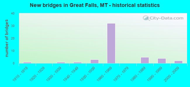
- New bridges - historical statistics
- 11910-1919
- 11930-1939
- 11940-1949
- 31950-1959
- 321960-1969
- 51980-1989
- 41990-1999
- 22000-2009
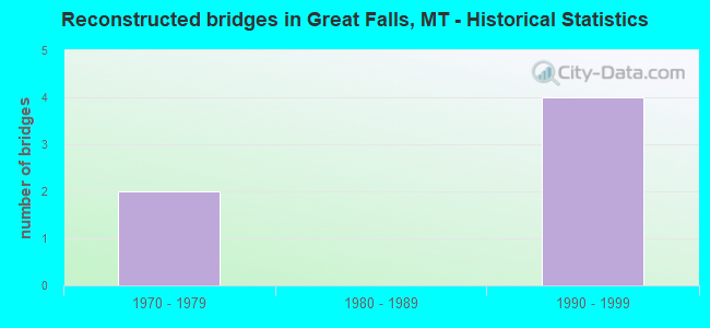
- Reconstructed bridges - Historical Statistics
- 21970-1979
- 01980-1989
- 41990-1999
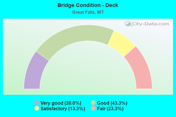
- Bridge Condition - Deck
- 20.0%Very good
- 43.3%Good
- 13.3%Satisfactory
- 23.3%Fair
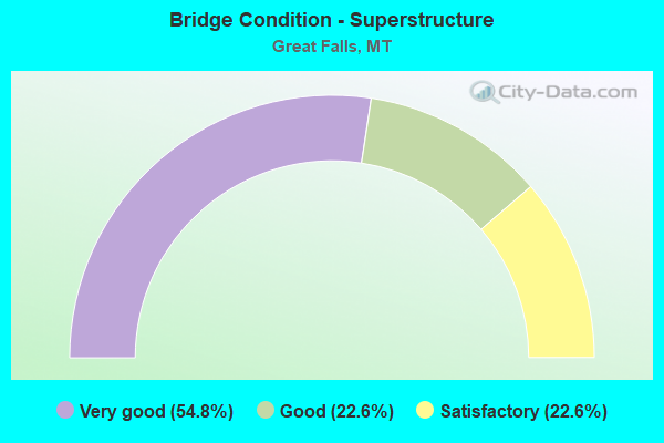
- Bridge Condition - Superstructure
- 54.8%Very good
- 22.6%Good
- 22.6%Satisfactory
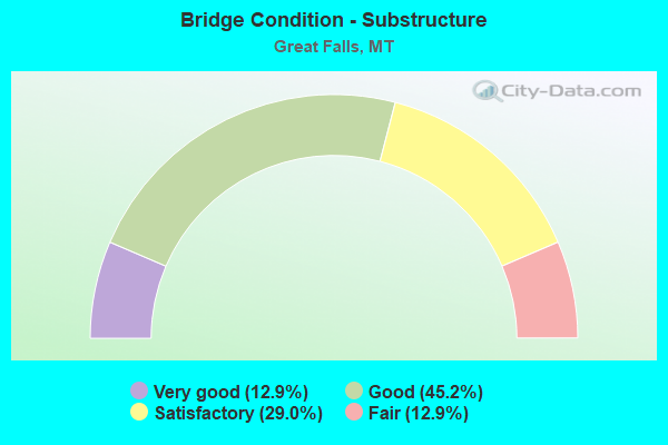
- Bridge Condition - Substructure
- 12.9%Very good
- 45.2%Good
- 29.0%Satisfactory
- 12.9%Fair
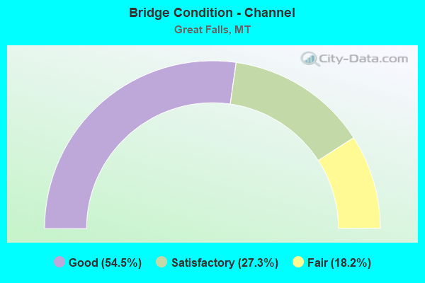
- Bridge Condition - Channel
- 54.5%Good
- 27.3%Satisfactory
- 18.2%Fair
Find on map >> Show street view
Structure Number: I00015279+09761, Location: GREAT FALLS (Lat: 47.499547, Lng: -111.342883), Route carried "on" structure: Interstate 15, Year Built: 1966, Status: Open, Structure Length: 14.78m (48.49ft), Average Daily Traffic: 10,410 (year 2020), Truck Traffic: 9%, Average Future Daily Traffic: 10,931 (year 2040), Design Load: HS 20, Features Intersected: SUN RIVER
Minimum Vertical Clearance: 30+ m (98+ ft), Kilometerpoint: 449.741, Lanes on structure: 2, Base Highway Network: Yes, Owner: State Highway Agency, Approaching Roadway Width: 11.3m (37.1ft), Skew: 1 degrees, Material/Design: Prestressed concrete, Design/Construction: Stringer/Multi-beam, Number Of Spans In Main Unit: 5, Length of Maximum Span: 29.6m (97.1ft), Curb-To-Curb Width: 8.5m (27.9ft), Out-to-Out Width: 9.8m (32.2ft)
Condition: Deck: Very good, Superstructure: Very good, Substructure: Satisfactory, Channel: Satisfactory, Operating Rating: 52.6 metric tons, Method Used To Determine Operating Rating: Load and Resistance Factor (LRFR), Inventory Rating: 40.8 metric tons, Method Used To Determine Inventory Rating: Load and Resistance Factor (LRFR), Structural Evaluation: Equal to present minimum criteria, Deck Geometry: High priority of corrective action, Waterway Adequacy: Equal to present desirable criteria, Approach Roadway Alignment: Better than present minimum criteria, Length Of Structure Improvement: 15.60m (51.18ft), Designated Inspection Frequency: Every 24 months, Underwater Inspection Frequency: Every 60 months, Inspection Date: December 2020, Underwater Inspection Date: August 2021, Bridge Improvement Cost: $922,000, Roadway Improvement Cost: $461,000, Total Project Cost: $1,383,000, Deck Structure Type: Concrete Cast-file-Place, Wearing Surface/Protective System: Wearing Surface: Latex Concrete
Find on map >> Show street view
Structure Number: I00015279+09762, Location: GREAT FALLS (Lat: 47.499547, Lng: -111.343144), Route carried "on" structure: Interstate 15, Year Built: 1966, Year Reconstructed: 1977, Status: Open, Structure Length: 14.78m (48.49ft), Average Daily Traffic: 10,410 (year 2020), Truck Traffic: 9%, Average Future Daily Traffic: 10,931 (year 2040), Design Load: HS 20, Features Intersected: SUN RIVER
Minimum Vertical Clearance: 30+ m (98+ ft), Kilometerpoint: 449.411, Lanes on structure: 2, Base Highway Network: Yes, Owner: State Highway Agency, Approaching Roadway Width: 11.3m (37.1ft), Skew: 1 degrees, Material/Design: Prestressed concrete, Design/Construction: Stringer/Multi-beam, Number Of Spans In Main Unit: 5, Length of Maximum Span: 29.6m (97.1ft), Curb-To-Curb Width: 8.5m (27.9ft), Out-to-Out Width: 9.8m (32.2ft)
Condition: Deck: Very good, Superstructure: Good, Substructure: Satisfactory, Channel: Satisfactory, Operating Rating: 52.6 metric tons, Method Used To Determine Operating Rating: Load and Resistance Factor (LRFR), Inventory Rating: 40.8 metric tons, Method Used To Determine Inventory Rating: Load and Resistance Factor (LRFR), Structural Evaluation: Equal to present minimum criteria, Deck Geometry: High priority of corrective action, Waterway Adequacy: Equal to present desirable criteria, Approach Roadway Alignment: Better than present minimum criteria, Length Of Structure Improvement: 15.60m (51.18ft), Designated Inspection Frequency: Every 24 months, Underwater Inspection Frequency: Every 60 months, Inspection Date: December 2020, Underwater Inspection Date: August 2021, Bridge Improvement Cost: $922,000, Roadway Improvement Cost: $461,000, Total Project Cost: $1,383,000, Deck Structure Type: Concrete Cast-file-Place, Wearing Surface/Protective System: Wearing Surface: Latex Concrete
Find on map >> Show street view
Structure Number: I00015280+00941, Location: GREAT FALLS (Lat: 47.501169, Lng: -111.342775), Route carried "on" structure: Interstate 15, Year Built: 1967, Status: Open, Structure Length: 3.81m (12.50ft), Average Daily Traffic: 10,410 (year 2020), Truck Traffic: 9%, Average Future Daily Traffic: 10,931 (year 2040), Design Load: HS 20, Features Intersected: SEP 5TH AVE SW
Minimum Vertical Clearance: 30+ m (98+ ft), Kilometerpoint: 449.921, Lanes on structure: 2, Lanes under structure: 2, Base Highway Network: Yes, Owner: State Highway Agency, Approaching Roadway Width: 11.9m (39.0ft), Material/Design: Prestressed concrete, Design/Construction: Stringer/Multi-beam, Number Of Spans In Main Unit: 3, Length of Maximum Span: 15.7m (51.5ft), Curb or Sidewalk Widths: Left: 0.1m (0.3ft), Right: 0.1m (0.3ft), Curb-To-Curb Width: 11.3m (37.1ft), Out-to-Out Width: 11.9m (39.0ft)
Condition: Deck: Very good, Superstructure: Very good, Substructure: Very good, Operating Rating: 36.2 metric tons, Method Used To Determine Operating Rating: Assigned rating based on Load Factor Design (LFD) reported in metric tons, Inventory Rating: 32.7 metric tons, Method Used To Determine Inventory Rating: Assigned rating based on Load Factor Design (LFD) reported in metric tons, Structural Evaluation: Equal to present desirable criteria, Deck Geometry: Somewhat better than minimum adequacy, Underclear: Equal to present minimum criteria, Approach Roadway Alignment: Equal to present desirable criteria, Designated Inspection Frequency: Every 48 months, Inspection Date: September 2020, Deck Structure Type: Concrete Cast-file-Place, Wearing Surface/Protective System: Wearing Surface: Latex Concrete
Find on map >> Show street view
Structure Number: I00015280+00942, Location: GREAT FALLS (Lat: 47.501161, Lng: -111.343089), Route carried "on" structure: Interstate 15, Year Built: 1967, Status: Open, Structure Length: 3.81m (12.50ft), Average Daily Traffic: 10,410 (year 2020), Truck Traffic: 9%, Average Future Daily Traffic: 10,931 (year 2040), Design Load: HS 20, Features Intersected: SEP 5TH AVE SW
Minimum Vertical Clearance: 30+ m (98+ ft), Kilometerpoint: 449.590, Lanes on structure: 2, Lanes under structure: 2, Base Highway Network: Yes, Owner: State Highway Agency, Approaching Roadway Width: 11.9m (39.0ft), Material/Design: Prestressed concrete, Design/Construction: Stringer/Multi-beam, Number Of Spans In Main Unit: 3, Length of Maximum Span: 15.7m (51.5ft), Curb or Sidewalk Widths: Left: 0.1m (0.3ft), Right: 0.1m (0.3ft), Curb-To-Curb Width: 11.3m (37.1ft), Out-to-Out Width: 11.9m (39.0ft)
Condition: Deck: Very good, Superstructure: Very good, Substructure: Good, Operating Rating: 34.4 metric tons, Method Used To Determine Operating Rating: Assigned rating based on Load Factor Design (LFD) reported in metric tons, Inventory Rating: 32.7 metric tons, Method Used To Determine Inventory Rating: Assigned rating based on Load Factor Design (LFD) reported in metric tons, Structural Evaluation: Better than present minimum criteria, Deck Geometry: Somewhat better than minimum adequacy, Underclear: Equal to present minimum criteria, Approach Roadway Alignment: Equal to present desirable criteria, Designated Inspection Frequency: Every 48 months, Inspection Date: September 2020, Deck Structure Type: Concrete Cast-file-Place, Wearing Surface/Protective System: Wearing Surface: Latex Concrete
Find on map >> Show street view
Structure Number: I00015282+05471, Location: 1M N GREAT FALLS (Lat: 47.521414, Lng: -111.379322), Route carried "on" structure: Interstate 15, Year Built: 1967, Status: Open, Structure Length: 11.54m (37.86ft), Average Daily Traffic: 5,946 (year 2020), Truck Traffic: 15%, Average Future Daily Traffic: 6,243 (year 2040), Design Load: HS 20, Features Intersected: INT EMERSON JCT-RR
Minimum Vertical Clearance: 30+ m (98+ ft), Kilometerpoint: 453.845, Lanes on structure: 2, Lanes under structure: 2, Base Highway Network: Yes, Owner: State Highway Agency, Approaching Roadway Width: 11.6m (38.1ft), Skew: 3 degrees, Material/Design: Prestressed concrete, Design/Construction: Stringer/Multi-beam, Number Of Spans In Main Unit: 6, Length of Maximum Span: 25.0m (82.0ft), Curb-To-Curb Width: 8.5m (27.9ft), Out-to-Out Width: 9.8m (32.2ft)
Condition: Deck: Good, Superstructure: Very good, Substructure: Good, Operating Rating: 54.4 metric tons, Method Used To Determine Operating Rating: Load and Resistance Factor (LRFR), Inventory Rating: 41.7 metric tons, Method Used To Determine Inventory Rating: Load and Resistance Factor (LRFR), Structural Evaluation: Better than present minimum criteria, Deck Geometry: High priority of corrective action, Underclear: Meets minimum limits, Approach Roadway Alignment: Better than present minimum criteria, Length Of Structure Improvement: 11.70m (38.39ft), Designated Inspection Frequency: Every 24 months, Inspection Date: December 2020, Bridge Improvement Cost: $673,000, Roadway Improvement Cost: $337,000, Total Project Cost: $1,010,000, Deck Structure Type: Concrete Cast-file-Place, Wearing Surface/Protective System: Wearing Surface: Latex Concrete
Find on map >> Show street view
Structure Number: I00015282+05472, Location: 1M N GREAT FALLS (Lat: 47.521489, Lng: -111.379686), Route carried "on" structure: Interstate 15, Year Built: 1967, Status: Open, Structure Length: 11.54m (37.86ft), Average Daily Traffic: 5,946 (year 2020), Truck Traffic: 15%, Average Future Daily Traffic: 6,243 (year 2040), Design Load: HS 20, Features Intersected: INT EMERSON JCT-RR
Minimum Vertical Clearance: 30+ m (98+ ft), Kilometerpoint: 453.520, Lanes on structure: 2, Lanes under structure: 2, Base Highway Network: Yes, Owner: State Highway Agency, Approaching Roadway Width: 11.6m (38.1ft), Skew: 3 degrees, Material/Design: Prestressed concrete, Design/Construction: Stringer/Multi-beam, Number Of Spans In Main Unit: 6, Length of Maximum Span: 25.0m (82.0ft), Curb-To-Curb Width: 8.5m (27.9ft), Out-to-Out Width: 9.8m (32.2ft)
Condition: Deck: Good, Superstructure: Very good, Substructure: Good, Operating Rating: 54.4 metric tons, Method Used To Determine Operating Rating: Load and Resistance Factor (LRFR), Inventory Rating: 41.7 metric tons, Method Used To Determine Inventory Rating: Load and Resistance Factor (LRFR), Structural Evaluation: Better than present minimum criteria, Deck Geometry: High priority of corrective action, Underclear: Meets minimum limits, Approach Roadway Alignment: Better than present minimum criteria, Length Of Structure Improvement: 11.80m (38.71ft), Designated Inspection Frequency: Every 24 months, Inspection Date: December 2020, Bridge Improvement Cost: $683,000, Roadway Improvement Cost: $342,000, Total Project Cost: $1,025,000, Deck Structure Type: Concrete Cast-file-Place, Wearing Surface/Protective System: Wearing Surface: Latex Concrete
Find on map >> Show street view
Structure Number: I00315000+00001, Location: GREAT FALLS (Lat: 47.485117, Lng: -111.344953), Route carried "on" structure: State highway 103, Year Built: 1967, Status: Open, Structure Length: 9.07m (29.76ft), Average Daily Traffic: 10,475 (year 2020), Truck Traffic: 5%, Average Future Daily Traffic: 10,999 (year 2040), Design Load: HS 20, Features Intersected: INT I 15, Facility Carried by Structure: I 315S
Minimum Vertical Clearance: 30+ m (98+ ft), Kilometerpoint: 0.019, Lanes on structure: 3, Lanes under structure: 4, Base Highway Network: Yes, Owner: State Highway Agency, Approaching Roadway Width: 14.6m (47.9ft), Skew: 23 degrees, Material/Design: Prestressed concrete, Design/Construction: Stringer/Multi-beam, Number Of Spans In Main Unit: 5, Length of Maximum Span: 21.8m (71.5ft), Curb-To-Curb Width: 15.2m (49.9ft), Out-to-Out Width: 16.5m (54.1ft)
Condition: Deck: Good, Superstructure: Very good, Substructure: Satisfactory, Operating Rating: 51.7 metric tons, Method Used To Determine Operating Rating: Load and Resistance Factor (LRFR), Inventory Rating: 39.9 metric tons, Method Used To Determine Inventory Rating: Load and Resistance Factor (LRFR), Structural Evaluation: Equal to present minimum criteria, Deck Geometry: Equal to present minimum criteria, Underclear: Somewhat better than minimum adequacy, Approach Roadway Alignment: Better than present minimum criteria, Designated Inspection Frequency: Every 24 months, Inspection Date: September 2020, Deck Structure Type: Concrete Cast-file-Place, Wearing Surface/Protective System: Wearing Surface: Epoxy Overlay
Find on map >> Show street view
Structure Number: I00315000+03421, Location: GREAT FALLS (Lat: 47.486806, Lng: -111.338186), Route carried "on" structure: Interstate 315, Year Built: 1967, Year Reconstructed: 1995, Status: Open, Structure Length: 4.57m (14.99ft), Average Daily Traffic: 15,247 (year 2020), Truck Traffic: 3%, Average Future Daily Traffic: 16,162 (year 2040), Design Load: HS 20, Features Intersected: FAU 5225-14TH ST SW
Minimum Vertical Clearance: 30+ m (98+ ft), Kilometerpoint: 0.538, Lanes on structure: 2, Lanes under structure: 2, Base Highway Network: Yes, Owner: State Highway Agency, Approaching Roadway Width: 10.9m (35.8ft), Skew: 2 degrees, Material/Design: Prestressed concrete, Design/Construction: Stringer/Multi-beam, Number Of Spans In Main Unit: 3, Length of Maximum Span: 15.7m (51.5ft), Curb-To-Curb Width: 10.9m (35.8ft), Out-to-Out Width: 11.9m (39.0ft)
Condition: Deck: Good, Superstructure: Very good, Substructure: Good, Operating Rating: 51.7 metric tons, Method Used To Determine Operating Rating: Load and Resistance Factor (LRFR), Inventory Rating: 39.9 metric tons, Method Used To Determine Inventory Rating: Load and Resistance Factor (LRFR), Structural Evaluation: Better than present minimum criteria, Deck Geometry: Meets minimum limits, Underclear: Meets minimum limits, Approach Roadway Alignment: Equal to present desirable criteria, Designated Inspection Frequency: Every 24 months, Inspection Date: September 2020, Deck Structure Type: Concrete Cast-file-Place, Wearing Surface/Protective System: Wearing Surface: Latex Concrete
Find on map >> Show street view
Structure Number: I00315000+03422, Location: GREAT FALLS (Lat: 47.486972, Lng: -111.338194), Route carried "on" structure: Interstate 315, Year Built: 1967, Year Reconstructed: 1995, Status: Open, Structure Length: 4.56m (14.96ft), Average Daily Traffic: 15,247 (year 2020), Truck Traffic: 3%, Average Future Daily Traffic: 16,162 (year 2040), Design Load: HS 20, Features Intersected: FAU 5225-14TH ST SW
Minimum Vertical Clearance: 5.96m (19.55ft), Kilometerpoint: 0.539, Lanes on structure: 3, Lanes under structure: 2, Base Highway Network: Yes, Owner: State Highway Agency, Approaching Roadway Width: 14.0m (45.9ft), Skew: 2 degrees, Material/Design: Prestressed concrete, Design/Construction: Stringer/Multi-beam, Number Of Spans In Main Unit: 3, Length of Maximum Span: 15.7m (51.5ft), Curb-To-Curb Width: 13.7m (44.9ft), Out-to-Out Width: 14.4m (47.2ft)
Condition: Deck: Good, Superstructure: Very good, Substructure: Good, Operating Rating: 53.5 metric tons, Method Used To Determine Operating Rating: Load and Resistance Factor (LRFR), Inventory Rating: 40.8 metric tons, Method Used To Determine Inventory Rating: Load and Resistance Factor (LRFR), Structural Evaluation: Better than present minimum criteria, Deck Geometry: High priority of corrective action, Underclear: Meets minimum limits, Approach Roadway Alignment: Equal to present desirable criteria, Designated Inspection Frequency: Every 24 months, Inspection Date: September 2020, Deck Structure Type: Concrete Cast-file-Place, Wearing Surface/Protective System: Wearing Surface: Latex Concrete
Find on map >> Show street view
Structure Number: I00315000+03423, Location: GREAT FALLS (Lat: 47.486642, Lng: -111.338183), Route carried "on" structure: Ramp Other road 315, Year Built: 1997, Status: Open, Structure Length: 4.15m (13.62ft), Average Daily Traffic: 8,973 (year 2020), Average Future Daily Traffic: 9,422 (year 2040), Design Load: HS 20, Features Intersected: FAU 5225-14TH ST SW
Minimum Vertical Clearance: 30+ m (98+ ft), Kilometerpoint: 1.606, Lanes on structure: 1, Lanes under structure: 2, Base Highway Network: Yes, Owner: State Highway Agency, Approaching Roadway Width: 7.3m (24.0ft), Skew: 1 degrees, Material/Design: Prestressed concrete, Design/Construction: Stringer/Multi-beam, Number Of Spans In Main Unit: 3, Length of Maximum Span: 14.4m (47.2ft), Curb-To-Curb Width: 7.1m (23.3ft), Out-to-Out Width: 8.0m (26.2ft)
Condition: Deck: Good, Superstructure: Very good, Substructure: Very good, Operating Rating: 34.6 metric tons, Method Used To Determine Operating Rating: Assigned rating based on Load Factor Design (LFD) reported in metric tons, Inventory Rating: 32.7 metric tons, Method Used To Determine Inventory Rating: Assigned rating based on Load Factor Design (LFD) reported in metric tons, Structural Evaluation: Equal to present desirable criteria, Deck Geometry: Equal to present minimum criteria, Underclear: Meets minimum limits, Approach Roadway Alignment: Better than present minimum criteria, Designated Inspection Frequency: Every 48 months, Inspection Date: May 2019, Deck Structure Type: Concrete Cast-file-Place, Wearing Surface/Protective System: Wearing Surface: Monolithic Concrete, Deck Protection: Epoxy Coated Reinforcing
Find on map >> Show street view
Structure Number: I00315001+00691, Location: GREAT FALLS (Lat: 47.487769, Lng: -111.335306), Route carried "on" structure: Spur Interstate 315, Year Built: 1946, Year Reconstructed: 1996, Status: Open, Structure Length: 5.42m (17.78ft), Average Daily Traffic: 23,786 (year 2020), Truck Traffic: 2%, Average Future Daily Traffic: 25,213 (year 2040), Design Load: HS 20, Features Intersected: RR, Facility Carried by Structure: BRANCH I 15-U.S. 8
Minimum Vertical Clearance: 30+ m (98+ ft), Kilometerpoint: 0.781, Lanes on structure: 3, Base Highway Network: Yes, Owner: State Highway Agency, Approaching Roadway Width: 13.6m (44.6ft), Material/Design: Steel continuous, Design/Construction: Stringer/Multi-beam, Number Of Spans In Main Unit: 3, Length of Maximum Span: 20.4m (66.9ft), Curb-To-Curb Width: 13.6m (44.6ft), Out-to-Out Width: 14.5m (47.6ft)
Condition: Deck: Good, Superstructure: Good, Substructure: Good, Operating Rating: 59.9 metric tons, Method Used To Determine Operating Rating: Load Factor (LF), Inventory Rating: 35.4 metric tons, Method Used To Determine Inventory Rating: Load Factor (LF), Structural Evaluation: Better than present minimum criteria, Deck Geometry: High priority of corrective action, Underclear: Somewhat better than minimum adequacy, Approach Roadway Alignment: Equal to present desirable criteria, Length Of Structure Improvement: 6.50m (21.33ft), Designated Inspection Frequency: Every 24 months, Inspection Date: May 2021, Bridge Improvement Cost: $503,000, Roadway Improvement Cost: $252,000, Total Project Cost: $755,000, Deck Structure Type: Concrete Cast-file-Place, Wearing Surface/Protective System: Wearing Surface: Monolithic Concrete
Find on map >> Show street view
Structure Number: I00315001+00692, Location: GREAT FALLS (Lat: 47.487936, Lng: -111.335278), Route carried "on" structure: Spur Interstate 315, Year Built: 1967, Year Reconstructed: 1996, Status: Open, Structure Length: 6.34m (20.80ft), Average Daily Traffic: 23,786 (year 2020), Truck Traffic: 2%, Average Future Daily Traffic: 25,213 (year 2040), Design Load: HS 20, Features Intersected: RR, Facility Carried by Structure: BRANCH I 15-U.S. 8
Minimum Vertical Clearance: 30+ m (98+ ft), Kilometerpoint: 0.783, Lanes on structure: 2, Base Highway Network: Yes, Owner: State Highway Agency, Approaching Roadway Width: 11.2m (36.7ft), Skew: 3 degrees, Material/Design: Steel, Design/Construction: Stringer/Multi-beam, Number Of Spans In Main Unit: 1, Number Of Approach Spans: 4, Length of Maximum Span: 15.7m (51.5ft), Curb-To-Curb Width: 11.2m (36.7ft), Out-to-Out Width: 12.1m (39.7ft)
Condition: Deck: Very good, Superstructure: Good, Substructure: Good, Operating Rating: 59.0 metric tons, Method Used To Determine Operating Rating: Load Factor (LF), Inventory Rating: 35.4 metric tons, Method Used To Determine Inventory Rating: Load Factor (LF), Structural Evaluation: Better than present minimum criteria, Deck Geometry: Somewhat better than minimum adequacy, Underclear: Somewhat better than minimum adequacy, Approach Roadway Alignment: Equal to present desirable criteria, Designated Inspection Frequency: Every 24 months, Inspection Date: May 2021, Deck Structure Type: Concrete Cast-file-Place, Wearing Surface/Protective System: Wearing Surface: Monolithic Concrete
Find on map >> Show street view
Structure Number: I00315001+00693, Location: GREAT FALLS (Lat: 47.488197, Lng: -111.335161), Route carried "on" structure: Ramp Interstate 315, Year Built: 1996, Status: Open, Structure Length: 5.67m (18.60ft), Average Daily Traffic: 6,088 (year 2020), Truck Traffic: 3%, Average Future Daily Traffic: 6,392 (year 2040), Design Load: HS 20, Features Intersected: RR, Facility Carried by Structure: OFF RAMP TO 14TH S
Minimum Vertical Clearance: 30+ m (98+ ft), Kilometerpoint: 0.218, Lanes on structure: 1, Owner: State Highway Agency, Approaching Roadway Width: 7.2m (23.6ft), Skew: 3 degrees, Material/Design: Prestressed concrete, Design/Construction: Stringer/Multi-beam, Number Of Spans In Main Unit: 5, Length of Maximum Span: 15.6m (51.2ft), Curb-To-Curb Width: 7.1m (23.3ft), Out-to-Out Width: 8.0m (26.2ft)
Condition: Deck: Good, Superstructure: Very good, Substructure: Very good, Operating Rating: 32.7 metric tons, Method Used To Determine Operating Rating: Assigned rating based on Load Factor Design (LFD) reported in metric tons, Inventory Rating: 32.7 metric tons, Method Used To Determine Inventory Rating: Assigned rating based on Load Factor Design (LFD) reported in metric tons, Structural Evaluation: Equal to present desirable criteria, Deck Geometry: Equal to present minimum criteria, Underclear: High priority of corrective action, Approach Roadway Alignment: Better than present minimum criteria, Designated Inspection Frequency: Every 48 months, Inspection Date: May 2019, Deck Structure Type: Concrete Cast-file-Place, Wearing Surface/Protective System: Wearing Surface: Monolithic Concrete, Deck Protection: Epoxy Coated Reinforcing
Find on map >> Show street view
Structure Number: L07701000+06501, Location: 1M W GREAT FALLS (Lat: 47.517261, Lng: -111.369867), Route carried "on" structure: Spur State highway 7701, Year Built: 1967, Status: Open, Structure Length: 7.53m (24.70ft), Average Daily Traffic: 1,075 (year 2020), Truck Traffic: 3%, Average Future Daily Traffic: 1,129 (year 2040), Design Load: HS 15, Features Intersected: SEP 34TH ST-I 15, Facility Carried by Structure: 34TH ST NW
Minimum Vertical Clearance: 30+ m (98+ ft), Kilometerpoint: 0.938, Lanes on structure: 2, Lanes under structure: 4, Owner: State Highway Agency, Approaching Roadway Width: 8.5m (27.9ft), Skew: 2 degrees, Material/Design: Prestressed concrete, Design/Construction: Stringer/Multi-beam, Number Of Spans In Main Unit: 4, Length of Maximum Span: 19.8m (65.0ft), Curb or Sidewalk Widths: Left: 0.0m, Right: 1.2m (3.9ft), Curb-To-Curb Width: 8.5m (27.9ft), Out-to-Out Width: 10.4m (34.1ft)
Condition: Deck: Very good, Superstructure: Very good, Substructure: Good, Operating Rating: 42.6 metric tons, Method Used To Determine Operating Rating: Load and Resistance Factor (LRFR), Inventory Rating: 32.7 metric tons, Method Used To Determine Inventory Rating: Load and Resistance Factor (LRFR), Structural Evaluation: Better than present minimum criteria, Deck Geometry: Somewhat better than minimum adequacy, Underclear: Equal to present minimum criteria, Approach Roadway Alignment: Equal to present minimum criteria, Designated Inspection Frequency: Every 24 months, Inspection Date: August 2020, Deck Structure Type: Concrete Cast-file-Place, Wearing Surface/Protective System: Wearing Surface: Monolithic Concrete
Find on map >> Show street view
Structure Number: L07852000+01001, Location: GREAT FALLS (Lat: 47.492728, Lng: -111.343369), Route carried "on" structure: Spur County highway 5225, Year Built: 1967, Status: Open, Structure Length: 9.75m (31.99ft), Average Daily Traffic: 1,166 (year 2020), Average Future Daily Traffic: 1,224 (year 2040), Design Load: HS 15, Features Intersected: SEP WEST HILL-I 15 127, Facility Carried by Structure: SUN RIVER RD
Minimum Vertical Clearance: 30+ m (98+ ft), Kilometerpoint: 2.599, Lanes on structure: 2, Lanes under structure: 4, Owner: State Highway Agency, Approaching Roadway Width: 8.5m (27.9ft), Skew: 3 degrees, Material/Design: Prestressed concrete, Design/Construction: Stringer/Multi-beam, Number Of Spans In Main Unit: 6, Length of Maximum Span: 20.3m (66.6ft), Curb or Sidewalk Widths: Left: 1.2m (3.9ft), Right: 0.0m, Curb-To-Curb Width: 8.5m (27.9ft), Out-to-Out Width: 10.4m (34.1ft)
Condition: Deck: Fair, Superstructure: Very good, Substructure: Satisfactory, Operating Rating: 39.0 metric tons, Method Used To Determine Operating Rating: Load and Resistance Factor (LRFR), Inventory Rating: 21.8 metric tons, Method Used To Determine Inventory Rating: Load and Resistance Factor (LRFR), Structural Evaluation: Somewhat better than minimum adequacy, Deck Geometry: Somewhat better than minimum adequacy, Underclear: Equal to present minimum criteria, Approach Roadway Alignment: Better than present minimum criteria, Designated Inspection Frequency: Every 24 months, Inspection Date: August 2020, Deck Structure Type: Concrete Cast-file-Place, Wearing Surface/Protective System: Wearing Surface: Monolithic Concrete
Find on map >> Show street view
Structure Number: L07877000+04001, Location: GREAT FALLS (Lat: 47.508264, Lng: -111.382064), Route carried "on" structure: Spur County highway 5240, Year Built: 1987, Status: Open, Structure Length: 6.71m (22.01ft), Average Daily Traffic: 1,255 (year 2020), Truck Traffic: 2%, Average Future Daily Traffic: 1,318 (year 2040), Design Load: HS 20, Features Intersected: SUN RIVER 056, Facility Carried by Structure: CENTRAL AVE W
Minimum Vertical Clearance: 30+ m (98+ ft), Kilometerpoint: 3.094, Lanes on structure: 2, Owner: County Highway Agency, Approaching Roadway Width: 8.5m (27.9ft), Material/Design: Steel continuous, Design/Construction: Stringer/Multi-beam, Number Of Spans In Main Unit: 3, Length of Maximum Span: 25.9m (85.0ft), Curb-To-Curb Width: 8.3m (27.2ft), Out-to-Out Width: 9.2m (30.2ft)
Condition: Deck: Good, Superstructure: Very good, Substructure: Good, Channel: Good, Operating Rating: 60.5 metric tons, Method Used To Determine Operating Rating: Load Factor (LF), Inventory Rating: 36.2 metric tons, Method Used To Determine Inventory Rating: Load Factor (LF), Structural Evaluation: Better than present minimum criteria, Deck Geometry: Meets minimum limits, Waterway Adequacy: Equal to present desirable criteria, Approach Roadway Alignment: Better than present minimum criteria, Designated Inspection Frequency: Every 24 months, Inspection Date: May 2021, Deck Structure Type: Concrete Cast-file-Place, Wearing Surface/Protective System: Wearing Surface: Monolithic Concrete, Deck Protection: Epoxy Coated Reinforcing
Find on map >> Show street view
Structure Number: P00010003+05341, Location: GREAT FALLS-15TH ST N (Lat: 47.521228, Lng: -111.281747), Route carried "on" structure: US 87, Year Built: 1962, Year Reconstructed: 1982, Status: Open, Structure Length: 34.31m (112.57ft), Average Daily Traffic: 12,549 (year 2020), Truck Traffic: 2%, Average Future Daily Traffic: 13,427 (year 2040), Design Load: HS 20, Features Intersected: MISSOURI R-RIVERS TRAIL
Minimum Vertical Clearance: 30+ m (98+ ft), Kilometerpoint: 3.026, Lanes on structure: 4, Base Highway Network: Yes, Owner: State Highway Agency, Approaching Roadway Width: 17.8m (58.4ft), Skew: 20 degrees, Material/Design: Steel continuous, Design/Construction: Girder and Floorbeam System, Number Of Spans In Main Unit: 6, Number Of Approach Spans: 3, Length of Maximum Span: 56.4m (185.0ft), Curb or Sidewalk Widths: Left: 1.1m (3.6ft), Right: 1.1m (3.6ft), Curb-To-Curb Width: 17.1m (56.1ft), Out-to-Out Width: 20.5m (67.3ft)
Condition: Deck: Fair, Superstructure: Satisfactory, Substructure: Fair, Channel: Fair, Operating Rating: 28.1 metric tons, Method Used To Determine Operating Rating: Load Factor (LF), Inventory Rating: 17.2 metric tons, Method Used To Determine Inventory Rating: Load Factor (LF), Structural Evaluation: Meets minimum limits, Deck Geometry: Somewhat better than minimum adequacy, Waterway Adequacy: Equal to present desirable criteria, Approach Roadway Alignment: Equal to present desirable criteria, Designated Inspection Frequency: Every 24 months, Critical Feature Inspection Frequency: Every 24 months, Underwater Inspection Frequency: Every 60 months, Inspection Date: June 2021, Critical Feature Inspection Date: June 2021, Underwater Inspection Date: August 2021, Deck Structure Type: Concrete Cast-file-Place, Wearing Surface/Protective System: Wearing Surface: Low Slump Concrete
Find on map >> Show street view
Structure Number: P00060000+04351, Location: 2M NE WHITE SULPHUR SPR (Lat: 46.570961, Lng: -110.853033), Route carried "on" structure: US 89, Year Built: 1955, Status: Open, Structure Length: 1.16m (3.81ft), Average Daily Traffic: 483 (year 2020), Truck Traffic: 12%, Average Future Daily Traffic: 507 (year 2040), Design Load: HS 15, Features Intersected: NORTH FORK SMITH RIVER
Minimum Vertical Clearance: 30+ m (98+ ft), Kilometerpoint: 0.701, Lanes on structure: 2, Base Highway Network: Yes, Owner: State Highway Agency, Approaching Roadway Width: 8.5m (27.9ft), Material/Design: Wood or Timber, Design/Construction: Stringer/Multi-beam, Number Of Spans In Main Unit: 2, Length of Maximum Span: 5.8m (19.0ft), Curb or Sidewalk Widths: Left: 0.1m (0.3ft), Right: 0.1m (0.3ft), Curb-To-Curb Width: 8.5m (27.9ft), Out-to-Out Width: 9.4m (30.8ft)
Condition: Deck: Good, Superstructure: Good, Substructure: Fair, Channel: Satisfactory, Operating Rating: 41.7 metric tons, Method Used To Determine Operating Rating: Allowable Stress (AS), Inventory Rating: 28.1 metric tons, Method Used To Determine Inventory Rating: Allowable Stress (AS), Structural Evaluation: Somewhat better than minimum adequacy, Deck Geometry: Somewhat better than minimum adequacy, Waterway Adequacy: Equal to present desirable criteria, Approach Roadway Alignment: Equal to present desirable criteria, Designated Inspection Frequency: Every 24 months, Inspection Date: August 2021, Deck Structure Type: Wood or Timber, Wearing Surface/Protective System: Wearing Surface: Bituminous
Find on map >> Show street view
Structure Number: P00060094+08281, Location: GREAT FALLS-10TH AVE S (Lat: 47.493433, Lng: -111.312181), Route carried "on" structure: US 89, Year Built: 1983, Status: Open, Structure Length: 64.66m (212.14ft), Average Daily Traffic: 25,598 (year 2020), Truck Traffic: 2%, Average Future Daily Traffic: 26,878 (year 2040), Design Load: HS 20, Features Intersected: MISSOURI RIVER-U5205-RR, Facility Carried by Structure: US 87-MT 3-MT 200
Minimum Vertical Clearance: 30+ m (98+ ft), Kilometerpoint: 153.363, Lanes on structure: 2, Lanes under structure: 2, Base Highway Network: Yes, Owner: State Highway Agency, Approaching Roadway Width: 12.2m (40.0ft), Skew: 4 degrees, Material/Design: Steel continuous, Design/Construction: Stringer/Multi-beam, Number Of Spans In Main Unit: 6, Number Of Approach Spans: 14, Length of Maximum Span: 56.4m (185.0ft), Curb or Sidewalk Widths: Left: 0.0m, Right: 2.7m (8.9ft), Curb-To-Curb Width: 12.1m (39.7ft), Out-to-Out Width: 15.8m (51.8ft)
Condition: Deck: Fair, Superstructure: Satisfactory, Substructure: Satisfactory, Channel: Good, Operating Rating: 37.2 metric tons, Method Used To Determine Operating Rating: Load and Resistance Factor (LRFR), Inventory Rating: 10.9 metric tons, Method Used To Determine Inventory Rating: Load and Resistance Factor (LRFR), Structural Evaluation: High priority of corrective action, Deck Geometry: Better than present minimum criteria, Underclear: Better than present minimum criteria, Waterway Adequacy: Equal to present desirable criteria, Approach Roadway Alignment: Equal to present desirable criteria, Designated Inspection Frequency: Every 24 months, Underwater Inspection Frequency: Every 60 months, Inspection Date: August 2020, Underwater Inspection Date: August 2021, Deck Structure Type: Concrete Cast-file-Place, Wearing Surface/Protective System: Wearing Surface: Monolithic Concrete
Find on map >> Show street view
Structure Number: P00060094+08282, Location: GREAT FALLS-10TH AVE S (Lat: 47.493358, Lng: -111.311575), Route carried "on" structure: US 89, Year Built: 1951, Status: Open, Structure Length: 63.77m (209.22ft), Average Daily Traffic: 25,598 (year 2020), Truck Traffic: 2%, Average Future Daily Traffic: 26,878 (year 2040), Design Load: HS 20, Features Intersected: MISSOURI RIVER-U5205-RR
Minimum Vertical Clearance: 30+ m (98+ ft), Kilometerpoint: 153.319, Lanes on structure: 2, Lanes under structure: 2, Base Highway Network: Yes, Owner: State Highway Agency, Approaching Roadway Width: 10.9m (35.8ft), Material/Design: Steel continuous, Design/Construction: Girder and Floorbeam System, Number Of Spans In Main Unit: 6, Number Of Approach Spans: 21, Length of Maximum Span: 56.4m (185.0ft), Curb or Sidewalk Widths: Left: 1.2m (3.9ft), Right: 1.2m (3.9ft), Curb-To-Curb Width: 8.5m (27.9ft), Out-to-Out Width: 10.9m (35.8ft)
Condition: Deck: Fair, Superstructure: Satisfactory, Substructure: Satisfactory, Channel: Good, Operating Rating: 37.2 metric tons, Method Used To Determine Operating Rating: Load Factor (LF), Inventory Rating: 22.7 metric tons, Method Used To Determine Inventory Rating: Load Factor (LF), Structural Evaluation: Somewhat better than minimum adequacy, Deck Geometry: High priority of corrective action, Underclear: Better than present minimum criteria, Waterway Adequacy: Equal to present desirable criteria, Approach Roadway Alignment: Better than present minimum criteria, Length Of Structure Improvement: 63.78m (209.25ft), Designated Inspection Frequency: Every 24 months, Critical Feature Inspection Frequency: Every 24 months, Underwater Inspection Frequency: Every 60 months, Inspection Date: August 2021, Critical Feature Inspection Date: August 2021, Underwater Inspection Date: August 2021, Bridge Improvement Cost: $4,454,000, Roadway Improvement Cost: $2,227,000, Total Project Cost: $6,681,000, Deck Structure Type: Concrete Cast-file-Place, Wearing Surface/Protective System: Wearing Surface: Latex Concrete
Find on map >> Show street view
Structure Number: S00226001+05191, Location: 3M S GREAT FALLS (Lat: 47.449403, Lng: -111.295825), Route carried "on" structure: City street 5207, Year Built: 1937, Status: Open, Structure Length: 1.77m (5.81ft), Average Daily Traffic: 1,805 (year 2020), Average Future Daily Traffic: 1,895 (year 2040), Design Load: H 15, Features Intersected: SAND COULEE CREEK, Facility Carried by Structure: LOWER RIVER RD
Minimum Vertical Clearance: 30+ m (98+ ft), Kilometerpoint: 5.533, Lanes on structure: 2, Owner: County Highway Agency, Approaching Roadway Width: 6.1m (20.0ft), Skew: 3 degrees, Material/Design: Wood or Timber, Design/Construction: Stringer/Multi-beam, Number Of Spans In Main Unit: 3, Length of Maximum Span: 5.8m (19.0ft), Curb or Sidewalk Widths: Left: 0.1m (0.3ft), Right: 0.1m (0.3ft), Curb-To-Curb Width: 7.0m (23.0ft), Out-to-Out Width: 7.3m (24.0ft)
Condition: Deck: Good, Superstructure: Good, Substructure: Satisfactory, Channel: Good, Operating Rating: 39.9 metric tons, Method Used To Determine Operating Rating: Allowable Stress (AS), Inventory Rating: 28.1 metric tons, Method Used To Determine Inventory Rating: Allowable Stress (AS), Structural Evaluation: Equal to present minimum criteria, Deck Geometry: High priority of corrective action, Waterway Adequacy: Equal to present desirable criteria, Approach Roadway Alignment: Better than present minimum criteria, Length Of Structure Improvement: 2.50m (8.20ft), Designated Inspection Frequency: Every 24 months, Inspection Date: November 2021, Bridge Improvement Cost: $83,000, Roadway Improvement Cost: $42,000, Total Project Cost: $125,000, Deck Structure Type: Wood or Timber, Wearing Surface/Protective System: Wearing Surface: Bituminous
Find on map >> Show street view
Structure Number: U05201000+01031, Location: GREAT FALLS-6TH ST SW (Lat: 47.491944, Lng: -111.328369), Route carried "on" structure: City street 122, Year Built: 1980, Status: Open, Structure Length: 15.42m (50.59ft), Average Daily Traffic: 13,794 (year 2020), Truck Traffic: 1%, Average Future Daily Traffic: 14,484 (year 2040), Design Load: HS 20, Features Intersected: SUN RIVER, Facility Carried by Structure: 6TH ST SW
Minimum Vertical Clearance: 30+ m (98+ ft), Kilometerpoint: 0.218, Lanes on structure: 5, Owner: State Highway Agency, Approaching Roadway Width: 21.9m (71.9ft), Skew: 23 degrees, Material/Design: Prestressed concrete, Design/Construction: Stringer/Multi-beam, Number Of Spans In Main Unit: 4, Length of Maximum Span: 38.7m (127.0ft), Curb or Sidewalk Widths: Left: 2.4m (7.9ft), Right: 2.4m (7.9ft), Curb-To-Curb Width: 26.8m (87.9ft), Out-to-Out Width: 33.2m (108.9ft)
Condition: Deck: Fair, Superstructure: Very good, Substructure: Good, Channel: Fair, Operating Rating: 61.7 metric tons, Method Used To Determine Operating Rating: Load and Resistance Factor (LRFR), Inventory Rating: 26.3 metric tons, Method Used To Determine Inventory Rating: Load and Resistance Factor (LRFR), Structural Evaluation: Equal to present minimum criteria, Deck Geometry: Superior to present desirable criteria, Waterway Adequacy: Equal to present desirable criteria, Approach Roadway Alignment: Equal to present desirable criteria, Length Of Structure Improvement: 16.20m (53.15ft), Designated Inspection Frequency: Every 24 months, Underwater Inspection Frequency: Every 60 months, Inspection Date: July 2020, Underwater Inspection Date: August 2021, Bridge Improvement Cost: $3,279,000, Roadway Improvement Cost: $1,640,000, Total Project Cost: $4,919,000, Deck Structure Type: Concrete Cast-file-Place, Wearing Surface/Protective System: Wearing Surface: Monolithic Concrete
Find on map >> Show street view
Structure Number: U05204000+03801, Location: BLACK EAGLE-SMELTER AVE (Lat: 47.524756, Lng: -111.281889), Route carried "on" structure: City street 5204, Year Built: 1963, Status: Open, Structure Length: 3.32m (10.89ft), Average Daily Traffic: 5,156 (year 2020), Truck Traffic: 1%, Average Future Daily Traffic: 5,414 (year 2040), Design Load: HS 20, Features Intersected: 15TH ST NE, Facility Carried by Structure: SMELTER AVE
Minimum Vertical Clearance: 30+ m (98+ ft), Kilometerpoint: 0.610, Lanes on structure: 2, Lanes under structure: 4, Owner: State Highway Agency, Approaching Roadway Width: 12.2m (40.0ft), Material/Design: Concrete, Design/Construction: Tee Beam, Number Of Spans In Main Unit: 3, Length of Maximum Span: 12.2m (40.0ft), Curb or Sidewalk Widths: Left: 2.8m (9.2ft), Right: 1.5m (4.9ft), Curb-To-Curb Width: 12.2m (40.0ft), Out-to-Out Width: 15.2m (49.9ft)
Condition: Deck: Satisfactory, Superstructure: Satisfactory, Substructure: Good, Operating Rating: 45.4 metric tons, Method Used To Determine Operating Rating: Load and Resistance Factor (LRFR), Inventory Rating: 35.4 metric tons, Method Used To Determine Inventory Rating: Load and Resistance Factor (LRFR), Structural Evaluation: Equal to present minimum criteria, Deck Geometry: Somewhat better than minimum adequacy, Underclear: High priority of replacement, Approach Roadway Alignment: Equal to present desirable criteria, Length Of Structure Improvement: 4.20m (13.78ft), Designated Inspection Frequency: Every 24 months, Inspection Date: June 2020, Bridge Improvement Cost: $324,000, Roadway Improvement Cost: $162,000, Total Project Cost: $486,000, Wearing Surface/Protective System: Wearing Surface: Monolithic Concrete
Find on map >> Show street view
Structure Number: U05205000+04681, Location: GREAT FALLS-OVERLOOK DR (Lat: 47.491492, Lng: -111.310569), Route carried "on" structure: City street 5205, Year Built: 2009, Status: Open, Structure Length: 4.59m (15.06ft), Average Daily Traffic: 5,069 (year 2020), Truck Traffic: 1%, Average Future Daily Traffic: 5,322 (year 2040), Design Load: HS 20+Mod, Features Intersected: RR BY WATERWORKS, Facility Carried by Structure: OVERLOOK DR
Minimum Vertical Clearance: 30+ m (98+ ft), Kilometerpoint: 0.747, Lanes on structure: 2, Owner: State Highway Agency, Approaching Roadway Width: 12.8m (42.0ft), Material/Design: Prestressed concrete, Design/Construction: Tee Beam, Number Of Spans In Main Unit: 3, Length of Maximum Span: 18.0m (59.1ft), Curb or Sidewalk Widths: Left: 3.1m (10.2ft), Right: 0.0m, Curb-To-Curb Width: 12.8m (42.0ft), Out-to-Out Width: 16.8m (55.1ft)
Condition: Deck: Good, Superstructure: Very good, Substructure: Very good, Operating Rating: 67.0 metric tons, Method Used To Determine Operating Rating: Load Factor (LF), Inventory Rating: 40.2 metric tons, Method Used To Determine Inventory Rating: Load Factor (LF), Structural Evaluation: Equal to present desirable criteria, Deck Geometry: Somewhat better than minimum adequacy, Underclear: Better than present minimum criteria, Approach Roadway Alignment: Better than present minimum criteria, Designated Inspection Frequency: Every 24 months, Inspection Date: May 2021, Deck Structure Type: Concrete Cast-file-Place, Wearing Surface/Protective System: Wearing Surface: Integral Concrete, Deck Protection: Epoxy Coated Reinforcing
Find on map >> Show street view
Structure Number: U05210000+00001, Location: GREAT FALLS-CENTRAL AVE W (Lat: 47.507839, Lng: -111.343911), Route carried "on" structure: State highway 103, Year Built: 1967, Status: Open, Structure Length: 8.11m (26.61ft), Average Daily Traffic: 10,475 (year 2020), Truck Traffic: 5%, Average Future Daily Traffic: 10,999 (year 2040), Design Load: HS 20, Features Intersected: INT CENTRAL AVE W-I 15, Facility Carried by Structure: CENTRAL AVE W
Minimum Vertical Clearance: 30+ m (98+ ft), Kilometerpoint: 0.161, Lanes on structure: 3, Lanes under structure: 4, Base Highway Network: Yes, Owner: State Highway Agency, Approaching Roadway Width: 14.6m (47.9ft), Skew: 32 degrees, Material/Design: Prestressed concrete, Design/Construction: Stringer/Multi-beam, Number Of Spans In Main Unit: 4, Length of Maximum Span: 21.8m (71.5ft), Curb or Sidewalk Widths: Left: 1.5m (4.9ft), Right: 1.5m (4.9ft), Curb-To-Curb Width: 22.0m (72.2ft), Out-to-Out Width: 25.1m (82.3ft)
Condition: Deck: Satisfactory, Superstructure: Very good, Substructure: Good, Operating Rating: 33.5 metric tons, Method Used To Determine Operating Rating: Assigned rating based on Load Factor Design (LFD) reported in metric tons, Inventory Rating: 32.7 metric tons, Method Used To Determine Inventory Rating: Assigned rating based on Load Factor Design (LFD) reported in metric tons, Structural Evaluation: Better than present minimum criteria, Deck Geometry: Superior to present desirable criteria, Underclear: Equal to present minimum criteria, Approach Roadway Alignment: Better than present minimum criteria, Designated Inspection Frequency: Every 24 months, Inspection Date: November 2020, Deck Structure Type: Concrete Cast-file-Place, Wearing Surface/Protective System: Wearing Surface: Latex Concrete
Find on map >> Show street view
Structure Number: U05210000+01601, Location: GREAT FALLS-CENTRAL AVE W (Lat: 47.507772, Lng: -111.340647), Route carried "on" structure: US 103, Year Built: 1967, Status: Open, Structure Length: 16.86m (55.31ft), Average Daily Traffic: 10,475 (year 2020), Truck Traffic: 5%, Average Future Daily Traffic: 10,999 (year 2040), Design Load: HS 20, Features Intersected: GALT AVE-RR, Facility Carried by Structure: CENTRAL AVE W
Minimum Vertical Clearance: 30+ m (98+ ft), Kilometerpoint: 0.232, Lanes on structure: 1, Lanes under structure: 2, Base Highway Network: Yes, Owner: State Highway Agency, Approaching Roadway Width: 8.3m (27.2ft), Skew: 4 degrees, Material/Design: Steel continuous, Design/Construction: Stringer/Multi-beam, Number Of Spans In Main Unit: 4, Number Of Approach Spans: 2, Length of Maximum Span: 45.1m (148.0ft), Curb or Sidewalk Widths: Left: 0.0m, Right: 1.5m (4.9ft), Curb-To-Curb Width: 8.3m (27.2ft), Out-to-Out Width: 16.0m (52.5ft)
Condition: Deck: Fair, Superstructure: Satisfactory, Substructure: Fair, Operating Rating: 45.4 metric tons, Method Used To Determine Operating Rating: Load and Resistance Factor (LRFR), Inventory Rating: 34.5 metric tons, Method Used To Determine Inventory Rating: Load and Resistance Factor (LRFR), Structural Evaluation: Somewhat better than minimum adequacy, Deck Geometry: High priority of corrective action, Underclear: High priority of replacement, Approach Roadway Alignment: Better than present minimum criteria, Length Of Structure Improvement: 17.50m (57.41ft), Designated Inspection Frequency: Every 24 months, Other Special Inspection Frequency: Every 48 months, Inspection Date: September 2020, Other Special Inspection Date: August 2020, Bridge Improvement Cost: $1,718,000, Roadway Improvement Cost: $859,000, Total Project Cost: $2,577,000, Deck Structure Type: Concrete Cast-file-Place, Wearing Surface/Protective System: Wearing Surface: Latex Concrete
Find on map >> Show street view
Structure Number: U05210000+01602, Location: GREAT FALLS-CENTRAL AVE W (Lat: 47.507889, Lng: -111.340742), Route carried "on" structure: State highway 103, Year Built: 1967, Status: Open, Structure Length: 16.40m (53.81ft), Average Daily Traffic: 10,475 (year 2020), Truck Traffic: 5%, Average Future Daily Traffic: 10,999 (year 2040), Design Load: HS 20, Features Intersected: GALT AVE-RR, Facility Carried by Structure: CENTRAL AVE W
Minimum Vertical Clearance: 30+ m (98+ ft), Kilometerpoint: 0.225, Lanes on structure: 2, Lanes under structure: 2, Base Highway Network: Yes, Owner: State Highway Agency, Approaching Roadway Width: 9.1m (29.9ft), Skew: 4 degrees, Material/Design: Steel continuous, Design/Construction: Stringer/Multi-beam, Number Of Spans In Main Unit: 4, Number Of Approach Spans: 2, Length of Maximum Span: 39.0m (128.0ft), Curb or Sidewalk Widths: Left: 1.5m (4.9ft), Right: 0.0m, Curb-To-Curb Width: 8.3m (27.2ft), Out-to-Out Width: 10.6m (34.8ft)
Condition: Deck: Fair, Superstructure: Satisfactory, Substructure: Fair, Operating Rating: 57.2 metric tons, Method Used To Determine Operating Rating: Load Factor (LF), Inventory Rating: 34.5 metric tons, Method Used To Determine Inventory Rating: Load Factor (LF), Structural Evaluation: Somewhat better than minimum adequacy, Deck Geometry: High priority of corrective action, Underclear: High priority of replacement, Approach Roadway Alignment: Better than present minimum criteria, Length Of Structure Improvement: 17.50m (57.41ft), Designated Inspection Frequency: Every 12 months, Other Special Inspection Frequency: Every 48 months, Inspection Date: November 2021, Other Special Inspection Date: August 2020, Bridge Improvement Cost: $1,140,000, Roadway Improvement Cost: $570,000, Total Project Cost: $1,710,000, Deck Structure Type: Concrete Cast-file-Place, Wearing Surface/Protective System: Wearing Surface: Latex Concrete
Find on map >> Show street view
Structure Number: U05210001+04961, Location: GREAT FALLS-CENTRAL AVE W (Lat: 47.506772, Lng: -111.312025), Route carried "on" structure: City street 103, Year Built: 1980, Status: Open, Structure Length: 29.38m (96.39ft), Average Daily Traffic: 24,446 (year 2020), Truck Traffic: 2%, Average Future Daily Traffic: 25,668 (year 2040), Design Load: HS 20, Features Intersected: MISSOURI RIVER-PED TRAIL, Facility Carried by Structure: CENTRAL AVE
Minimum Vertical Clearance: 30+ m (98+ ft), Kilometerpoint: 2.408, Lanes on structure: 4, Owner: State Highway Agency, Approaching Roadway Width: 20.7m (67.9ft), Material/Design: Prestressed concrete, Design/Construction: Stringer/Multi-beam, Number Of Spans In Main Unit: 8, Length of Maximum Span: 39.9m (130.9ft), Curb or Sidewalk Widths: Left: 2.4m (7.9ft), Right: 2.4m (7.9ft), Curb-To-Curb Width: 20.7m (67.9ft), Out-to-Out Width: 27.1m (88.9ft)
Condition: Deck: Good, Superstructure: Good, Substructure: Good, Channel: Good, Operating Rating: 68.4 metric tons, Method Used To Determine Operating Rating: Assigned rating based on Load Factor Design (LFD) reported in metric tons, Inventory Rating: 32.7 metric tons, Method Used To Determine Inventory Rating: Assigned rating based on Load Factor Design (LFD) reported in metric tons, Structural Evaluation: Better than present minimum criteria, Deck Geometry: Superior to present desirable criteria, Waterway Adequacy: Equal to present desirable criteria, Approach Roadway Alignment: Equal to present desirable criteria, Designated Inspection Frequency: Every 24 months, Underwater Inspection Frequency: Every 60 months, Inspection Date: June 2020, Underwater Inspection Date: August 2021, Deck Structure Type: Concrete Cast-file-Place, Wearing Surface/Protective System: Wearing Surface: Latex Concrete
Find on map >> Show street view
Structure Number: U05211000+01071, Location: GREAT FALLS-9TH-10 ST N (Lat: 47.520689, Lng: -111.291106), Route carried "on" structure: City street 104, Year Built: 1996, Status: Open, Structure Length: 37.56m (123.23ft), Average Daily Traffic: 14,003 (year 2020), Truck Traffic: 1%, Average Future Daily Traffic: 14,703 (year 2040), Design Load: HS 20, Features Intersected: MISSOURI RIVER, Facility Carried by Structure: 9TH ST N
Minimum Vertical Clearance: 30+ m (98+ ft), Kilometerpoint: 0.351, Lanes on structure: 4, Base Highway Network: Yes, Owner: State Highway Agency, Approaching Roadway Width: 15.8m (51.8ft), Skew: 2 degrees, Material/Design: Prestressed concrete, Design/Construction: Stringer/Multi-beam, Number Of Spans In Main Unit: 10, Length of Maximum Span: 37.7m (123.7ft), Curb or Sidewalk Widths: Left: 3.0m (9.8ft), Right: 0.0m, Curb-To-Curb Width: 15.8m (51.8ft), Out-to-Out Width: 20.0m (65.6ft)
Condition: Deck: Satisfactory, Superstructure: Very good, Substructure: Good, Channel: Good, Operating Rating: 49.0 metric tons, Method Used To Determine Operating Rating: Load and Resistance Factor (LRFR), Inventory Rating: 35.4 metric tons, Method Used To Determine Inventory Rating: Load and Resistance Factor (LRFR), Structural Evaluation: Better than present minimum criteria, Deck Geometry: Meets minimum limits, Waterway Adequacy: Equal to present desirable criteria, Approach Roadway Alignment: Equal to present desirable criteria, Designated Inspection Frequency: Every 24 months, Underwater Inspection Frequency: Every 60 months, Inspection Date: July 2020, Underwater Inspection Date: August 2021, Deck Structure Type: Concrete Cast-file-Place, Wearing Surface/Protective System: Wearing Surface: Monolithic Concrete, Deck Protection: Epoxy Coated Reinforcing
Find on map >> Show street view
Structure Number: U05212000+05881, Location: 1M SW GREAT FALLS (Lat: 47.472319, Lng: -111.360983), Route carried "on" structure: City street 5212, Year Built: 1967, Status: Open, Structure Length: 7.34m (24.08ft), Average Daily Traffic: 2,551 (year 2020), Truck Traffic: 1%, Average Future Daily Traffic: 2,679 (year 2040), Design Load: HS 20, Features Intersected: INT GORE HILL-I 15, Facility Carried by Structure: AIRPORT DR
Minimum Vertical Clearance: 30+ m (98+ ft), Kilometerpoint: 0.013, Lanes on structure: 2, Lanes under structure: 4, Owner: State Highway Agency, Approaching Roadway Width: 9.0m (29.5ft), Skew: 1 degrees, Material/Design: Prestressed concrete, Design/Construction: Stringer/Multi-beam, Number Of Spans In Main Unit: 4, Length of Maximum Span: 18.7m (61.4ft), Curb-To-Curb Width: 8.5m (27.9ft), Out-to-Out Width: 9.7m (31.8ft)
Condition: Deck: Satisfactory, Superstructure: Good, Substructure: Satisfactory, Operating Rating: 48.1 metric tons, Method Used To Determine Operating Rating: Load and Resistance Factor (LRFR), Inventory Rating: 37.2 metric tons, Method Used To Determine Inventory Rating: Load and Resistance Factor (LRFR), Structural Evaluation: Equal to present minimum criteria, Deck Geometry: Meets minimum limits, Underclear: Somewhat better than minimum adequacy, Approach Roadway Alignment: Better than present minimum criteria, Designated Inspection Frequency: Every 24 months, Inspection Date: October 2021, Deck Structure Type: Concrete Cast-file-Place, Wearing Surface/Protective System: Wearing Surface: Latex Concrete
Find on map >> Show street view
Structure Number: U05217001+05401, Location: GREAT FALLS-25TH ST N (Lat: 47.515753, Lng: -111.264169), Route carried "on" structure: City street 5217, Year Built: 1914, Status: Open, Structure Length: 2.18m (7.15ft), Average Daily Traffic: 4,330 (year 2020), Truck Traffic: 4%, Average Future Daily Traffic: 4,547 (year 2040), Features Intersected: ABANDONED RAILROAD, Facility Carried by Structure: 25TH ST N
Minimum Vertical Clearance: 30+ m (98+ ft), Kilometerpoint: 0.159, Lanes on structure: 2, Owner: City or Municipal Highway Agency, Approaching Roadway Width: 12.5m (41.0ft), Material/Design: Concrete, Design/Construction: Arch - Deck, Number Of Spans In Main Unit: 1, Length of Maximum Span: 21.8m (71.5ft), Curb or Sidewalk Widths: Left: 0.3m (1.0ft), Right: 0.3m (1.0ft), Curb-To-Curb Width: 12.5m (41.0ft), Out-to-Out Width: 13.2m (43.3ft)
Condition: Superstructure: Satisfactory, Substructure: Satisfactory, Operating Rating: 54.4 metric tons, Method Used To Determine Operating Rating: Field evaluation and documented engineering judgment, Inventory Rating: 32.7 metric tons, Method Used To Determine Inventory Rating: Field evaluation and documented engineering judgment, Structural Evaluation: Equal to present minimum criteria, Deck Geometry: Equal to present minimum criteria, Underclear: Superior to present desirable criteria, Approach Roadway Alignment: Equal to present desirable criteria, Designated Inspection Frequency: Every 24 months, Inspection Date: May 2021, Deck Structure Type: Concrete Cast-file-Place, Wearing Surface/Protective System: Wearing Surface: Bituminous
Find on map >> Show street view
Structure Number: U05221000+09101, Location: GREAT FALLS (Lat: 47.531067, Lng: -111.232533), Route carried "on" structure: County highway 73509, Year Built: 2002, Status: Open, Structure Length: 0.91m (2.99ft), Average Daily Traffic: 886 (year 2020), Truck Traffic: 1%, Average Future Daily Traffic: 930 (year 2040), Features Intersected: RIVERS EDGE TRAIL, Facility Carried by Structure: GIANT SPRINGS RD
Minimum Vertical Clearance: 30+ m (98+ ft), Kilometerpoint: 1.497, Lanes on structure: 2, Owner: City or Municipal Highway Agency, Approaching Roadway Width: 8.8m (28.9ft), Material/Design: Concrete, Design/Construction: Culvert, Number Of Spans In Main Unit: 1, Length of Maximum Span: 9.1m (29.9ft)
Condition: Culverts: Good, Structural Evaluation: Better than present minimum criteria, Approach Roadway Alignment: Better than present minimum criteria, Designated Inspection Frequency: Every 24 months, Inspection Date: March 2020
Find on map >> Show street view
Structure Number: I00015280+00941, Location: GREAT FALLS (Lat: 47.501169, Lng: -111.342775), Route carried "under" structure: ServiceCounty highway 7544, Year Built: 1967, Structure Length: 0. m, Average Daily Traffic: 662 (year 2020), Truck Traffic: 3%, Features Intersected: SEP 5TH AVE SW, Facility Carried by Structure: I 15
Minimum Vertical Clearance: 4.52m (14.83ft), Kilometerpoint: 0.396, Lanes on structure: 2, Lanes under structure: 2, Material/Design: Prestressed concrete, Design/Construction: Stringer/Multi-beam, Length of Maximum Span: 15.7m (51.5ft)
Find on map >> Show street view
Structure Number: I00015280+00942, Location: GREAT FALLS (Lat: 47.501161, Lng: -111.343089), Route carried "under" structure: ServiceCounty highway 7544, Year Built: 1967, Structure Length: 0. m, Average Daily Traffic: 662 (year 2020), Truck Traffic: 3%, Features Intersected: SEP 5TH AVE SW, Facility Carried by Structure: I 15
Minimum Vertical Clearance: 4.52m (14.83ft), Kilometerpoint: 0.420, Lanes on structure: 2, Lanes under structure: 2, Material/Design: Prestressed concrete, Design/Construction: Stringer/Multi-beam, Length of Maximum Span: 15.7m (51.5ft)
Find on map >> Show street view
Structure Number: I00015282+05471, Location: 1M N GREAT FALLS (Lat: 47.521414, Lng: -111.379322), Route carried "under" structure: City street 7611, Year Built: 1967, Structure Length: 0. m, Average Daily Traffic: 4,095 (year 2020), Truck Traffic: 1%, Features Intersected: INT EMERSON JCT-RR, Facility Carried by Structure: I 15
Minimum Vertical Clearance: 7.21m (23.65ft), Kilometerpoint: 12.895, Lanes on structure: 2, Lanes under structure: 2, Material/Design: Prestressed concrete, Design/Construction: Stringer/Multi-beam, Length of Maximum Span: 25.0m (82.0ft)
Find on map >> Show street view
Structure Number: I00015282+05472, Location: 1M N GREAT FALLS (Lat: 47.521489, Lng: -111.379686), Route carried "under" structure: City street 7611, Year Built: 1967, Structure Length: 0. m, Average Daily Traffic: 4,095 (year 2020), Truck Traffic: 1%, Features Intersected: INT EMERSON JCT-RR, Facility Carried by Structure: I 15
Minimum Vertical Clearance: 6.87m (22.54ft), Kilometerpoint: 12.876, Lanes on structure: 2, Lanes under structure: 2, Material/Design: Prestressed concrete, Design/Construction: Stringer/Multi-beam, Length of Maximum Span: 25.0m (82.0ft)
Find on map >> Show street view
Structure Number: I00315000+00001, Location: GREAT FALLS (Lat: 47.485117, Lng: -111.344953), Route carried "under" structure: Interstate 15, Year Built: 1967, Structure Length: 0. m, Average Daily Traffic: 10,410 (year 2020), Truck Traffic: 9%, Features Intersected: INT I 15
Minimum Vertical Clearance: 5.47m (17.95ft), Kilometerpoint: 448.118, Lanes on structure: 3, Lanes under structure: 4, Material/Design: Prestressed concrete, Design/Construction: Stringer/Multi-beam, Length of Maximum Span: 21.8m (71.5ft)
Find on map >> Show street view
Structure Number: I00315000+03421, Location: GREAT FALLS (Lat: 47.486806, Lng: -111.338186), Route carried "under" structure: City street 5225, Year Built: 1967, Structure Length: 0. m, Average Daily Traffic: 2,776 (year 2020), Features Intersected: FAU 5225-14TH ST SW, Facility Carried by Structure: I 315S
Minimum Vertical Clearance: 5.75m (18.86ft), Kilometerpoint: 1.624, Lanes on structure: 2, Lanes under structure: 2, Material/Design: Prestressed concrete, Design/Construction: Stringer/Multi-beam, Length of Maximum Span: 15.7m (51.5ft)
Find on map >> Show street view
Structure Number: I00315000+03422, Location: GREAT FALLS (Lat: 47.486972, Lng: -111.338194), Route carried "under" structure: City street 5225, Year Built: 1967, Structure Length: 0. m, Average Daily Traffic: 2,776 (year 2020), Features Intersected: FAU 5225-14TH ST SW, Facility Carried by Structure: I 315S
Minimum Vertical Clearance: 5.20m (17.06ft), Kilometerpoint: 1.642, Lanes on structure: 3, Lanes under structure: 2, Material/Design: Prestressed concrete, Design/Construction: Stringer/Multi-beam, Length of Maximum Span: 15.7m (51.5ft)
Find on map >> Show street view
Structure Number: I00315000+03423, Location: GREAT FALLS (Lat: 47.486642, Lng: -111.338183), Route carried "under" structure: City street 5225, Year Built: 1997, Structure Length: 0. m, Average Daily Traffic: 8,973 (year 2020), Features Intersected: FAU 5225-14TH ST SW, Facility Carried by Structure: I 315 S
Minimum Vertical Clearance: 5.20m (17.06ft), Kilometerpoint: 1.606, Lanes on structure: 1, Lanes under structure: 2, Material/Design: Prestressed concrete, Design/Construction: Stringer/Multi-beam, Length of Maximum Span: 14.4m (47.2ft)
Find on map >> Show street view
Structure Number: L07701000+06501, Location: 1M W GREAT FALLS (Lat: 47.517261, Lng: -111.369867), Route carried "under" structure: Interstate 15, Year Built: 1967, Structure Length: 0. m, Average Daily Traffic: 5,946 (year 2020), Truck Traffic: 15%, Features Intersected: SEP 34TH ST-I 15, Facility Carried by Structure: 34TH ST NW
Minimum Vertical Clearance: 5.08m (16.67ft), Kilometerpoint: 452.967, Lanes on structure: 2, Lanes under structure: 4, Material/Design: Prestressed concrete, Design/Construction: Stringer/Multi-beam, Length of Maximum Span: 19.8m (65.0ft)
Find on map >> Show street view
Structure Number: L07852000+01001, Location: GREAT FALLS (Lat: 47.492728, Lng: -111.343369), Route carried "under" structure: Interstate 15, Year Built: 1967, Structure Length: 0. m, Average Daily Traffic: 10,410 (year 2020), Truck Traffic: 9%, Features Intersected: SEP WEST HILL-I 15 127, Facility Carried by Structure: SUN RIVER RD
Minimum Vertical Clearance: 5.07m (16.63ft), Kilometerpoint: 448.975, Lanes on structure: 2, Lanes under structure: 4, Material/Design: Prestressed concrete, Design/Construction: Stringer/Multi-beam, Length of Maximum Span: 20.3m (66.6ft)
Find on map >> Show street view
Structure Number: P00060094+08281, Location: GREAT FALLS-10TH AVE S (Lat: 47.493433, Lng: -111.312181), Route carried "under" structure: City street 5205, Year Built: 1983, Structure Length: 0. m, Average Daily Traffic: 5,241 (year 2020), Truck Traffic: 1%, Features Intersected: MISSOURI RIVER-U5205-RR, Facility Carried by Structure: US 87-MT 3-MT 200
Minimum Vertical Clearance: 4.22m (13.85ft), Kilometerpoint: 0.954, Lanes on structure: 2, Lanes under structure: 2, Material/Design: Steel continuous, Design/Construction: Stringer/Multi-beam, Length of Maximum Span: 56.4m (185.0ft)
Find on map >> Show street view
Structure Number: P00060094+08282, Location: GREAT FALLS-10TH AVE S (Lat: 47.493358, Lng: -111.311575), Route carried "under" structure: City street 5205, Year Built: 1951, Structure Length: 0. m, Average Daily Traffic: 5,241 (year 2020), Truck Traffic: 1%, Features Intersected: MISSOURI RIVER-U5205-RR, Facility Carried by Structure: US 89-MT 3-MT 200
Minimum Vertical Clearance: 5.85m (19.19ft), Kilometerpoint: 0.958, Lanes on structure: 2, Lanes under structure: 2, Material/Design: Steel continuous, Design/Construction: Girder and Floorbeam System, Length of Maximum Span: 56.4m (185.0ft)
Find on map >> Show street view
Structure Number: U05204000+03801, Location: BLACK EAGLE-SMELTER AVE (Lat: 47.524756, Lng: -111.281889), Route carried "under" structure: US 10, Year Built: 1963, Structure Length: 0. m, Average Daily Traffic: 12,549 (year 2020), Truck Traffic: 2%, Features Intersected: 15TH ST NE, Facility Carried by Structure: SMELTER AVE
Minimum Vertical Clearance: 4.43m (14.53ft), Kilometerpoint: 3.402, Lanes on structure: 2, Lanes under structure: 4, Material/Design: Concrete, Design/Construction: Tee Beam, Length of Maximum Span: 12.2m (40.0ft)
Find on map >> Show street view
Structure Number: U05210000+00001, Location: GREAT FALLS-CENTRAL AVE W (Lat: 47.507839, Lng: -111.343911), Route carried "under" structure: Interstate 15, Year Built: 1967, Structure Length: 0. m, Average Daily Traffic: 5,946 (year 2020), Truck Traffic: 15%, Features Intersected: INT CENTRAL AVE W-I 15, Facility Carried by Structure: CENTRAL AVE W
Minimum Vertical Clearance: 5.08m (16.67ft), Kilometerpoint: 450.681, Lanes on structure: 3, Lanes under structure: 4, Material/Design: Prestressed concrete, Design/Construction: Stringer/Multi-beam, Length of Maximum Span: 21.8m (71.5ft)
Find on map >> Show street view
Structure Number: U05210000+01601, Location: GREAT FALLS-CENTRAL AVE W (Lat: 47.507772, Lng: -111.340647), Route carried "under" structure: ServiceCity street 72517, Year Built: 1967, Structure Length: 0. m, Average Daily Traffic: 653 (year 2020), Truck Traffic: 3%, Features Intersected: GALT AVE-RR, Facility Carried by Structure: CENTRAL AVE W
Minimum Vertical Clearance: 5.08m (16.67ft), Kilometerpoint: 0.029, Lanes on structure: 1, Lanes under structure: 2, Material/Design: Steel continuous, Design/Construction: Stringer/Multi-beam, Length of Maximum Span: 45.1m (148.0ft)