Bridge Statistics for Grenada, Mississippi (MS)
Condition, Traffic, Stress, Structural Evaluation, Project Costs
- National Bridge Inventory (NBI) Statistics
- 94Number of bridges
- 1,332ft / 406mTotal length
- $8,251,855,000Total costs
- 401,371Total average daily traffic
- 74,548Total average daily truck traffic
- National Bridge Inventory (NBI) Registered Bridges for Grenada
- No street view available for this location
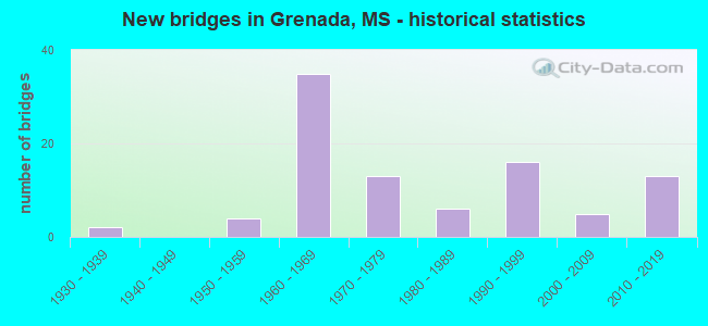
- New bridges - historical statistics
- 21930-1939
- 41950-1959
- 351960-1969
- 131970-1979
- 61980-1989
- 161990-1999
- 52000-2009
- 132010-2019


- Bridge Condition - Deck
- 22.4%Very good
- 34.3%Good
- 40.3%Satisfactory
- 1.5%Fair
- 1.5%Serious

- Bridge Condition - Superstructure
- 31.3%Very good
- 47.8%Good
- 13.4%Satisfactory
- 7.5%Fair

- Bridge Condition - Substructure
- 28.4%Very good
- 52.2%Good
- 16.4%Satisfactory
- 1.5%Fair
- 1.5%Serious

- Bridge Condition - Channel
- 1.5%Excellent
- 25.8%Very good
- 40.9%Good
- 21.2%Satisfactory
- 7.6%Fair
- 3.0%Poor

- Bridge Condition - Culverts
- 84.6%Good
- 15.4%Satisfactory
Find on map >> Show street view
Structure Number: SA2200000000103, Location: SEC 33 T22N R 5E (Lat: 33.732194, Lng: -89.784944), Route carried "on" structure: City street 320, Year Built: 1982, Status: Open, Structure Length: 1.73m (5.68ft), Average Daily Traffic: 50 (year 2015), Average Future Daily Traffic: 75 (year 2035), Design Load: H 15, Features Intersected: CREEK, Facility Carried by Structure: BAILEY RD
Minimum Vertical Clearance: 30+ m (98+ ft), Kilometerpoint: 1.207, Lanes on structure: 2, Owner: City or Municipal Highway Agency, Approaching Roadway Width: 5.5m (18.0ft), Material/Design: Concrete, Design/Construction: Channel Beam, Number Of Spans In Main Unit: 3, Length of Maximum Span: 5.8m (19.0ft), Curb or Sidewalk Widths: Left: 0.2m (0.7ft), Right: 0.2m (0.7ft), Curb-To-Curb Width: 8.1m (26.6ft), Out-to-Out Width: 8.5m (27.9ft)
Condition: Deck: Good, Superstructure: Good, Substructure: Good, Channel: Good, Operating Rating: 58.3 metric tons, Method Used To Determine Operating Rating: Load Factor (LF) rating reported by rating factor (RF) method using MS18 loading, Inventory Rating: 35.0 metric tons, Method Used To Determine Inventory Rating: Load Factor (LF) rating reported by rating factor (RF) method using MS18 loading, Structural Evaluation: Better than present minimum criteria, Deck Geometry: Equal to present minimum criteria, Waterway Adequacy: Equal to present desirable criteria, Approach Roadway Alignment: Equal to present minimum criteria, Length Of Structure Improvement: 2.83m (9.28ft), Designated Inspection Frequency: Every 24 months, Inspection Date: January 2020, Bridge Improvement Cost: $169,000, Roadway Improvement Cost: $17,000, Total Project Cost: $208,000 ( Estimate for 2016), Deck Structure Type: Concrete Precast Panels, Wearing Surface/Protective System: Wearing Surface: Monolithic Concrete
Find on map >> Show street view
Structure Number: 11000550222084A, Location: I 55 OVER US 51 (Lat: 33.823531, Lng: -89.839189), Route carried "under" structure: US 51, Year Built: 1965, Structure Length: 0. m, Average Daily Traffic: 2,400 (year 2017), Truck Traffic: 20%, Features Intersected: US 51, Facility Carried by Structure: I 55
Minimum Vertical Clearance: 4.55m (14.93ft), Kilometerpoint: 19.137, Lanes on structure: 2, Lanes under structure: 2, Material/Design: Prestressed concrete, Design/Construction: Stringer/Multi-beam, Length of Maximum Span: 18.3m (60.0ft)
Find on map >> Show street view
Structure Number: 11000550222084B, Location: I 55 OVER US 51 (Lat: 33.823289, Lng: -89.838911), Route carried "under" structure: US 51, Year Built: 1965, Structure Length: 0. m, Average Daily Traffic: 4,700 (year 2017), Truck Traffic: 20%, Features Intersected: US 51, Facility Carried by Structure: I 55
Minimum Vertical Clearance: 4.55m (14.93ft), Kilometerpoint: 19.101, Lanes on structure: 2, Lanes under structure: 2, Material/Design: Prestressed concrete, Design/Construction: Stringer/Multi-beam, Length of Maximum Span: 18.3m (60.0ft)
Find on map >> Show street view
Structure Number: 11000550222112A, Location: I 55 OVER SR 7 NORTH (Lat: 33.862561, Lng: -89.842250), Route carried "under" structure: State highway 7, Year Built: 1960, Structure Length: 0. m, Average Daily Traffic: 2,500 (year 2017), Truck Traffic: 12%, Features Intersected: SR 7, Facility Carried by Structure: I 55
Minimum Vertical Clearance: 5.02m (16.47ft), Kilometerpoint: 13.620, Lanes on structure: 2, Lanes under structure: 2, Material/Design: Prestressed concrete, Design/Construction: Stringer/Multi-beam, Length of Maximum Span: 15.5m (50.9ft)
Find on map >> Show street view
Structure Number: 11000550222112B, Location: I 55 OVER SR 7 NORTH (Lat: 33.862711, Lng: -89.842011), Route carried "under" structure: State highway 7, Year Built: 1960, Structure Length: 0. m, Average Daily Traffic: 3,300 (year 2017), Truck Traffic: 12%, Features Intersected: SR 7, Facility Carried by Structure: I 55
Minimum Vertical Clearance: 5.30m (17.39ft), Kilometerpoint: 13.647, Lanes on structure: 2, Lanes under structure: 2, Material/Design: Prestressed concrete, Design/Construction: Stringer/Multi-beam, Length of Maximum Span: 15.5m (50.9ft)
Find on map >> Show street view
Structure Number: 31000070220670A, Location: SR 7/SR 8 OVER I 55 (Lat: 33.786069, Lng: -89.840719), Route carried "under" structure: Interstate 55, Year Built: 1965, Structure Length: 0. m, Average Daily Traffic: 8,500 (year 2017), Truck Traffic: 30%, Features Intersected: I 55, Facility Carried by Structure: SR 7
Minimum Vertical Clearance: 5.72m (18.77ft), Kilometerpoint: 12.608, Lanes on structure: 2, Lanes under structure: 4, Material/Design: Prestressed concrete, Design/Construction: Stringer/Multi-beam, Length of Maximum Span: 21.3m (69.9ft)
Find on map >> Show street view
Structure Number: 31000070220670A, Location: SR 7/SR 8 OVER I 55 (Lat: 33.786050, Lng: -89.840431), Route carried "under" structure: Interstate 55, Year Built: 1965, Structure Length: 0. m, Average Daily Traffic: 8,500 (year 2017), Truck Traffic: 30%, Features Intersected: I 55, Facility Carried by Structure: SR 7
Minimum Vertical Clearance: 5.28m (17.32ft), Kilometerpoint: 12.592, Lanes on structure: 2, Lanes under structure: 4, Material/Design: Prestressed concrete, Design/Construction: Stringer/Multi-beam, Length of Maximum Span: 21.3m (69.9ft)
Find on map >> Show street view
Structure Number: 31000070220670B, Location: SR 7/SR 8 OVER I 55 (Lat: 33.785889, Lng: -89.840731), Route carried "under" structure: Interstate 55, Year Built: 1965, Structure Length: 0. m, Average Daily Traffic: 8,500 (year 2017), Truck Traffic: 30%, Features Intersected: I 55, Facility Carried by Structure: SR 7
Minimum Vertical Clearance: 5.36m (17.59ft), Kilometerpoint: 12.627, Lanes on structure: 2, Lanes under structure: 4, Material/Design: Prestressed concrete, Design/Construction: Stringer/Multi-beam, Length of Maximum Span: 21.3m (69.9ft)
Find on map >> Show street view
Structure Number: 31000070220670B, Location: SR 7/SR 8 OVER I 55 (Lat: 33.785869, Lng: -89.840439), Route carried "under" structure: Interstate 55, Year Built: 1965, Structure Length: 0. m, Average Daily Traffic: 8,500 (year 2017), Truck Traffic: 30%, Features Intersected: I 55, Facility Carried by Structure: SR 7
Minimum Vertical Clearance: 4.95m (16.24ft), Kilometerpoint: 12.572, Lanes on structure: 2, Lanes under structure: 4, Material/Design: Prestressed concrete, Design/Construction: Stringer/Multi-beam, Length of Maximum Span: 21.3m (69.9ft)
Find on map >> Show street view
Structure Number: 41000550222003A, Location: 5.5 MI S SR 7 SOUTH (Lat: 33.707650, Lng: -89.826131), Route carried "under" structure: Interstate 55, Year Built: 1965, Structure Length: 0. m, Average Daily Traffic: 7,000 (year 2017), Truck Traffic: 20%, Features Intersected: I 55, Facility Carried by Structure: HALLS ROAD
Minimum Vertical Clearance: 4.94m (16.21ft), Kilometerpoint: 21.573, Lanes on structure: 2, Lanes under structure: 2, Material/Design: Concrete continuous, Design/Construction: Box Beam or Girders - Single/Spread, Length of Maximum Span: 27.4m (89.9ft)
Find on map >> Show street view
Structure Number: 41000550222003B, Location: 5.5 MI S SR 7 SOUTH (Lat: 33.710519, Lng: -89.824489), Route carried "under" structure: Interstate 55, Year Built: 1965, Structure Length: 0. m, Average Daily Traffic: 7,000 (year 2017), Truck Traffic: 20%, Features Intersected: I 55, Facility Carried by Structure: HALLS ROAD
Minimum Vertical Clearance: 4.90m (16.08ft), Kilometerpoint: 3.956, Lanes on structure: 2, Lanes under structure: 2, Material/Design: Concrete continuous, Design/Construction: Box Beam or Girders - Single/Spread, Length of Maximum Span: 27.4m (89.9ft)
Find on map >> Show street view
Structure Number: 41000550222042A, Location: 1.9 MI S SR 7 SOUTH (Lat: 33.761481, Lng: -89.844000), Route carried "under" structure: Interstate 55, Year Built: 1964, Structure Length: 0. m, Average Daily Traffic: 7,000 (year 2017), Truck Traffic: 20%, Features Intersected: I 55, Facility Carried by Structure: SWEETHOME ROAD
Minimum Vertical Clearance: 5.11m (16.77ft), Kilometerpoint: 15.372, Lanes on structure: 2, Lanes under structure: 2, Material/Design: Prestressed concrete, Design/Construction: Stringer/Multi-beam, Length of Maximum Span: 21.6m (70.9ft)
Find on map >> Show street view
Structure Number: 41000550222042B, Location: 1.9 MI S SR 7 SOUTH (Lat: 33.763031, Lng: -89.841339), Route carried "under" structure: Interstate 55, Year Built: 1964, Structure Length: 0. m, Average Daily Traffic: 7,000 (year 2017), Truck Traffic: 20%, Features Intersected: I 55, Facility Carried by Structure: SWEETHOME ROAD
Minimum Vertical Clearance: 5.28m (17.32ft), Kilometerpoint: 10.037, Lanes on structure: 2, Lanes under structure: 2, Material/Design: Prestressed concrete, Design/Construction: Stringer/Multi-beam, Length of Maximum Span: 21.6m (70.9ft)
Find on map >> Show street view
Structure Number: 41000550222077, Location: 1.9 MI N SR 7/SR 8 (Lat: 33.813650, Lng: -89.839319), Route carried "under" structure: Interstate 55, Year Built: 1994, Structure Length: 0. m, Average Daily Traffic: 8,500 (year 2017), Truck Traffic: 30%, Features Intersected: I 55, Facility Carried by Structure: PAPER MILL ROAD
Minimum Vertical Clearance: 5.03m (16.50ft), Kilometerpoint: 15.659, Lanes on structure: 2, Lanes under structure: 4, Material/Design: Prestressed concrete continuous, Design/Construction: Stringer/Multi-beam, Length of Maximum Span: 30.5m (100.1ft)
Find on map >> Show street view
Structure Number: 41000550222077, Location: 1.9 MI N SR 7/SR 8 (Lat: 33.813661, Lng: -89.839689), Route carried "under" structure: Interstate 55, Year Built: 1994, Structure Length: 0. m, Average Daily Traffic: 8,500 (year 2017), Truck Traffic: 30%, Features Intersected: I 55, Facility Carried by Structure: PAPER MILL ROAD
Minimum Vertical Clearance: 4.88m (16.01ft), Kilometerpoint: 9.543, Lanes on structure: 2, Lanes under structure: 4, Material/Design: Prestressed concrete continuous, Design/Construction: Stringer/Multi-beam, Length of Maximum Span: 30.5m (100.1ft)