Bridge Statistics for Hammond, Louisiana (LA)
Condition, Traffic, Stress, Structural Evaluation, Project Costs
- National Bridge Inventory (NBI) Statistics
- 137Number of bridges
- 1,483ft / 452mTotal length
- $20,654,000Total costs
- 2,492,807Total average daily traffic
- 226,691Total average daily truck traffic
- National Bridge Inventory (NBI) Registered Bridges for Hammond
- No street view available for this location
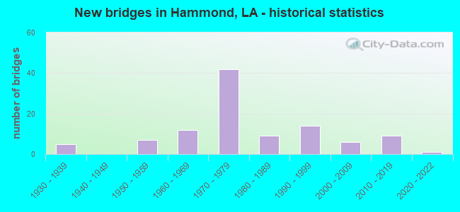
- New bridges - historical statistics
- 51930-1939
- 71950-1959
- 121960-1969
- 421970-1979
- 91980-1989
- 141990-1999
- 62000-2009
- 92010-2019
- 12020-2022

- Reconstructed bridges - Historical Statistics
- 11950-1959
- 01960-1969
- 01970-1979
- 01980-1989
- 41990-1999
- 12000-2009


- Bridge Condition - Deck
- 1.1%Excellent
- 5.4%Very good
- 52.7%Good
- 22.6%Satisfactory
- 15.1%Fair
- 3.2%Poor

- Bridge Condition - Superstructure
- 1.1%Excellent
- 20.4%Very good
- 35.5%Good
- 21.5%Satisfactory
- 18.3%Fair
- 3.2%Poor

- Bridge Condition - Substructure
- 1.1%Excellent
- 25.8%Very good
- 40.9%Good
- 9.7%Satisfactory
- 7.5%Fair
- 11.8%Poor
- 3.2%Serious

- Bridge Condition - Channel
- 1.2%Excellent
- 13.1%Very good
- 42.9%Good
- 27.4%Satisfactory
- 14.3%Fair
- 1.2%Poor

- Bridge Condition - Culverts
- 8.3%Very good
- 50.0%Good
- 33.3%Satisfactory
- 8.3%Fair
Find on map >> Show street view
Structure Number: 625330289902751, Location: 002 MI N US 51&I-12 FAGON (Lat: 30.482719, Lng: -90.465911), Route carried "on" structure: Business County highway , Year Built: 2003, Status: Open, Structure Length: 1.95m (6.40ft), Average Daily Traffic: 13,316 (year 2021), Average Future Daily Traffic: 14,648 (year 2041), Design Load: HS 20, Features Intersected: ARNOLD'S CREEK, Facility Carried by Structure: C.M. Fagan Rd
Minimum Vertical Clearance: 30+ m (98+ ft), Kilometerpoint: 0.000, Lanes on structure: 2, Base Highway Network: Yes, Owner: City or Municipal Highway Agency, Approaching Roadway Width: 14.6m (47.9ft), Skew: 24 degrees, Material/Design: Concrete, Design/Construction: Culvert, Number Of Spans In Main Unit: 4, Length of Maximum Span: 4.3m (14.1ft), Curb-To-Curb Width: 11.6m (38.1ft), Out-to-Out Width: 22.6m (74.1ft)
Condition: Channel: Satisfactory, Culverts: Fair, Operating Rating: 42.1 metric tons, Method Used To Determine Operating Rating: Load and Resistance Factor Rating (LRFR) rating reported by rating factor(RF) method using HL-93 loadings, Inventory Rating: 32.4 metric tons, Method Used To Determine Inventory Rating: Load and Resistance Factor Rating (LRFR) rating reported by rating factor(RF) method using HL-93 loadings, Structural Evaluation: Somewhat better than minimum adequacy, Waterway Adequacy: Better than present minimum criteria, Approach Roadway Alignment: Equal to present desirable criteria, Designated Inspection Frequency: Every 24 months, Inspection Date: June 2021, Deck Structure Type: Concrete Cast-file-Place
Find on map >> Show street view
Structure Number: 625330291902851, Location: SOUTH MOONEY AVE, HAMMOND (Lat: 30.489589, Lng: -90.474261), Route carried "on" structure: County highway , Year Built: 1984, Status: Open, Structure Length: 1.16m (3.81ft), Average Daily Traffic: 200 (year 2016), Average Future Daily Traffic: 140 (year 2036), Design Load: HS 20, Features Intersected: CREEK, Facility Carried by Structure: S. Mooney ave.
Minimum Vertical Clearance: 30+ m (98+ ft), Kilometerpoint: 0.000, Lanes on structure: 2, Owner: City or Municipal Highway Agency, Approaching Roadway Width: 6.4m (21.0ft), Material/Design: Concrete, Design/Construction: Slab, Number Of Spans In Main Unit: 2, Length of Maximum Span: 5.8m (19.0ft), Curb-To-Curb Width: 8.5m (27.9ft), Out-to-Out Width: 9.4m (30.8ft)
Condition: Deck: Good, Superstructure: Good, Substructure: Good, Channel: Good, Operating Rating: 34.7 metric tons, Method Used To Determine Operating Rating: Load and Resistance Factor Rating (LRFR) rating reported by rating factor(RF) method using HL-93 loadings, Inventory Rating: 26.6 metric tons, Method Used To Determine Inventory Rating: Load and Resistance Factor Rating (LRFR) rating reported by rating factor(RF) method using HL-93 loadings, Structural Evaluation: Equal to present minimum criteria, Deck Geometry: Equal to present minimum criteria, Waterway Adequacy: Better than present minimum criteria, Approach Roadway Alignment: Equal to present desirable criteria, Designated Inspection Frequency: Every 24 months, Inspection Date: April 2021, Deck Structure Type: Concrete Precast Panels
Find on map >> Show street view
Structure Number: 625330293902391, Location: 0.4 MI. S OF LA. 1067 (Lat: 30.489031, Lng: -90.398061), Route carried "on" structure: County highway , Year Built: 1996, Status: Open, Structure Length: 2.59m (8.50ft), Average Daily Traffic: 50 (year 2016), Average Future Daily Traffic: 55 (year 2036), Design Load: HS 20, Features Intersected: SELSERS CREEK, Facility Carried by Structure: S. Coburn Rd
Minimum Vertical Clearance: 30+ m (98+ ft), Kilometerpoint: 0.000, Lanes on structure: 2, Base Highway Network: Yes, Owner: County Highway Agency, Approaching Roadway Width: 5.2m (17.1ft), Material/Design: Steel, Design/Construction: Stringer/Multi-beam, Number Of Spans In Main Unit: 3, Length of Maximum Span: 13.1m (43.0ft), Curb-To-Curb Width: 4.9m (16.1ft), Out-to-Out Width: 5.1m (16.7ft)
Condition: Deck: Satisfactory, Superstructure: Satisfactory, Substructure: Satisfactory, Channel: Satisfactory, Operating Rating: 39.9 metric tons, Method Used To Determine Operating Rating: Allowable Stress (AS), Inventory Rating: 32.7 metric tons, Method Used To Determine Inventory Rating: Allowable Stress (AS), Structural Evaluation: Equal to present minimum criteria, Deck Geometry: High priority of corrective action, Waterway Adequacy: Better than present minimum criteria, Approach Roadway Alignment: Better than present minimum criteria, Length Of Structure Improvement: 3.38m (11.09ft), Designated Inspection Frequency: Every 24 months, Critical Feature Inspection Frequency: Every 24 months, Inspection Date: June 2021, Critical Feature Inspection Date: June 2021, Bridge Improvement Cost: $202,000, Total Project Cost: $303,000 ( Estimate for 2016), Deck Structure Type: Concrete Cast-file-Place
Find on map >> Show street view
Structure Number: 625330294902411, Location: 1.3 M.N/E JCT.LA 3158&I12 (Lat: 30.494031, Lng: -90.404219), Route carried "on" structure: County highway , Year Built: 1958, Status: Posted for load, Structure Length: 3.66m (12.01ft), Average Daily Traffic: 860 (year 2016), Truck Traffic: 6%, Average Future Daily Traffic: 602 (year 2036), Design Load: H 15, Features Intersected: SELSERS CREEK, Facility Carried by Structure: Old Covington Hwy.
Minimum Vertical Clearance: 30+ m (98+ ft), Kilometerpoint: 0.000, Lanes on structure: 2, Base Highway Network: Yes, Owner: County Highway Agency, Approaching Roadway Width: 10.4m (34.1ft), Material/Design: Concrete, Design/Construction: Slab, Number Of Spans In Main Unit: 6, Length of Maximum Span: 6.1m (20.0ft), Curb-To-Curb Width: 7.3m (24.0ft), Out-to-Out Width: 8.8m (28.9ft)
Condition: Deck: Satisfactory, Superstructure: Satisfactory, Substructure: Good, Channel: Fair, Operating Rating: 24.0 metric tons, Method Used To Determine Operating Rating: Load and Resistance Factor Rating (LRFR) rating reported by rating factor(RF) method using HL-93 loadings, Inventory Rating: 18.5 metric tons, Method Used To Determine Inventory Rating: Load and Resistance Factor Rating (LRFR) rating reported by rating factor(RF) method using HL-93 loadings, Structural Evaluation: Somewhat better than minimum adequacy, Deck Geometry: Meets minimum limits, Waterway Adequacy: Better than present minimum criteria, Approach Roadway Alignment: Equal to present desirable criteria, Bridge Posting: Required (Relationship of Operating Rating to Maximum Legal Load: 0.1 - 9.9% below), Designated Inspection Frequency: Every 24 months, Inspection Date: June 2021, Deck Structure Type: Concrete Cast-file-Place
Find on map >> Show street view
Structure Number: 625330295902801, Location: 5TH AV,HAMMOND PHOENIX SQ (Lat: 30.491811, Lng: -90.469031), Route carried "on" structure: County highway , Year Built: 1978, Status: Open, Structure Length: 2.35m (7.71ft), Average Daily Traffic: 3,306 (year 2020), Average Future Daily Traffic: 3,637 (year 2040), Design Load: HS 20, Features Intersected: CREEK, Facility Carried by Structure: Phoenix square
Minimum Vertical Clearance: 30+ m (98+ ft), Kilometerpoint: 0.000, Lanes on structure: 2, Owner: City or Municipal Highway Agency, Approaching Roadway Width: 7.9m (25.9ft), Skew: 3 degrees, Material/Design: Concrete, Design/Construction: Slab, Number Of Spans In Main Unit: 4, Length of Maximum Span: 5.8m (19.0ft), Curb or Sidewalk Widths: Left: 1.5m (4.9ft), Right: 0.0m, Curb-To-Curb Width: 8.5m (27.9ft), Out-to-Out Width: 10.4m (34.1ft)
Condition: Deck: Satisfactory, Superstructure: Satisfactory, Substructure: Satisfactory, Channel: Satisfactory, Operating Rating: 30.5 metric tons, Method Used To Determine Operating Rating: Load and Resistance Factor Rating (LRFR) rating reported by rating factor(RF) method using HL-93 loadings, Inventory Rating: 21.1 metric tons, Method Used To Determine Inventory Rating: Load and Resistance Factor Rating (LRFR) rating reported by rating factor(RF) method using HL-93 loadings, Structural Evaluation: Somewhat better than minimum adequacy, Deck Geometry: Meets minimum limits, Waterway Adequacy: Better than present minimum criteria, Approach Roadway Alignment: Equal to present desirable criteria, Designated Inspection Frequency: Every 24 months, Inspection Date: April 2021, Deck Structure Type: Concrete Precast Panels, Wearing Surface/Protective System: Wearing Surface: Bituminous
Find on map >> Show street view
Structure Number: 625330296902591, Location: 1 MI W OF JCT 3158 & (Lat: 30.493881, Lng: -90.430311), Route carried "on" structure: County highway , Year Built: 1957, Status: Posted for load, Structure Length: 5.49m (18.01ft), Average Daily Traffic: 7,323 (year 2020), Average Future Daily Traffic: 8,056 (year 2040), Design Load: HS 15, Features Intersected: PONCHATOULA CREEK, Facility Carried by Structure: Old Covington Hwy.
Minimum Vertical Clearance: 30+ m (98+ ft), Kilometerpoint: 0.000, Lanes on structure: 2, Owner: County Highway Agency, Approaching Roadway Width: 7.6m (24.9ft), Material/Design: Concrete, Design/Construction: Slab, Number Of Spans In Main Unit: 9, Length of Maximum Span: 6.1m (20.0ft), Curb-To-Curb Width: 7.3m (24.0ft), Out-to-Out Width: 8.8m (28.9ft)
Condition: Deck: Satisfactory, Superstructure: Satisfactory, Substructure: Satisfactory, Channel: Satisfactory, Operating Rating: 22.4 metric tons, Method Used To Determine Operating Rating: Load and Resistance Factor Rating (LRFR) rating reported by rating factor(RF) method using HL-93 loadings, Inventory Rating: 17.2 metric tons, Method Used To Determine Inventory Rating: Load and Resistance Factor Rating (LRFR) rating reported by rating factor(RF) method using HL-93 loadings, Structural Evaluation: Meets minimum limits, Deck Geometry: High priority of replacement, Waterway Adequacy: Better than present minimum criteria, Approach Roadway Alignment: Equal to present desirable criteria, Bridge Posting: Required (Relationship of Operating Rating to Maximum Legal Load: 0.1 - 9.9% below), Length Of Structure Improvement: 6.40m (21.00ft), Designated Inspection Frequency: Every 24 months, Inspection Date: June 2021, Bridge Improvement Cost: $382,000, Total Project Cost: $573,000 ( Estimate for 2016), Deck Structure Type: Concrete Cast-file-Place
Find on map >> Show street view
Structure Number: 625330296902851, Location: 1.4 MI SE OF RT 190 (Lat: 30.494111, Lng: -90.473931), Route carried "on" structure: County highway , Year Built: 1975, Status: Posted for load, Structure Length: 1.74m (5.71ft), Average Daily Traffic: 5,021 (year 2020), Average Future Daily Traffic: 5,524 (year 2040), Design Load: H 10, Features Intersected: CREEK, Facility Carried by Structure: Phoenix square
Minimum Vertical Clearance: 30+ m (98+ ft), Kilometerpoint: 0.000, Lanes on structure: 2, Owner: City or Municipal Highway Agency, Approaching Roadway Width: 6.7m (22.0ft), Material/Design: Wood or Timber, Design/Construction: Stringer/Multi-beam, Number Of Spans In Main Unit: 3, Length of Maximum Span: 5.8m (19.0ft), Curb-To-Curb Width: 7.6m (24.9ft), Out-to-Out Width: 8.3m (27.2ft)
Condition: Deck: Fair, Superstructure: Fair, Substructure: Poor, Channel: Satisfactory, Operating Rating: 18.1 metric tons, Method Used To Determine Operating Rating: Allowable Stress (AS), Inventory Rating: 13.6 metric tons, Method Used To Determine Inventory Rating: Allowable Stress (AS), Structural Evaluation: High priority of corrective action, Deck Geometry: High priority of replacement, Waterway Adequacy: Better than present minimum criteria, Approach Roadway Alignment: Equal to present minimum criteria, Bridge Posting: Required (Relationship of Operating Rating to Maximum Legal Load: 20.0 - 29.9% below), Designated Inspection Frequency: Every 24 months, Other Special Inspection Frequency: Every 12 months, Inspection Date: April 2021, Other Special Inspection Date: April 2020, Deck Structure Type: Wood or Timber, Wearing Surface/Protective System: Wearing Surface: Bituminous
Find on map >> Show street view
Structure Number: 625330297902891, Location: 0.6 M.S.OF US 190 &HWY 51 (Lat: 30.493019, Lng: -90.478431), Route carried "on" structure: County highway , Year Built: 2002, Status: Open, Structure Length: 0.73m (2.40ft), Average Daily Traffic: 883 (year 2020), Average Future Daily Traffic: 972 (year 2040), Design Load: HS 20, Features Intersected: CANAL, Facility Carried by Structure: Reed ave.
Minimum Vertical Clearance: 30+ m (98+ ft), Kilometerpoint: 0.000, Lanes on structure: 2, Base Highway Network: Yes, Owner: City or Municipal Highway Agency, Approaching Roadway Width: 6.4m (21.0ft), Skew: 6 degrees, Material/Design: Concrete, Design/Construction: Culvert, Number Of Spans In Main Unit: 2, Length of Maximum Span: 3.4m (11.2ft), Curb or Sidewalk Widths: Left: 1.5m (4.9ft), Right: 1.5m (4.9ft), Curb-To-Curb Width: 6.4m (21.0ft), Out-to-Out Width: 10.1m (33.1ft)
Condition: Channel: Good, Culverts: Good, Operating Rating: 28.5 metric tons, Method Used To Determine Operating Rating: Load and Resistance Factor Rating (LRFR) rating reported by rating factor(RF) method using HL-93 loadings, Inventory Rating: 22.0 metric tons, Method Used To Determine Inventory Rating: Load and Resistance Factor Rating (LRFR) rating reported by rating factor(RF) method using HL-93 loadings, Structural Evaluation: Somewhat better than minimum adequacy, Deck Geometry: High priority of corrective action, Waterway Adequacy: Equal to present desirable criteria, Approach Roadway Alignment: Equal to present desirable criteria, Length Of Structure Improvement: 1.34m (4.40ft), Designated Inspection Frequency: Every 24 months, Inspection Date: March 2021, Bridge Improvement Cost: $80,000, Total Project Cost: $120,000 ( Estimate for 2016), Deck Structure Type: Concrete Cast-file-Place
Find on map >> Show street view
Structure Number: 625330298903061, Location: 0.8 mi. n of la. 1040 (Lat: 30.496269, Lng: -90.506431), Route carried "on" structure: County highway , Year Built: 1960, Status: Posted for load, Structure Length: 3.69m (12.11ft), Average Daily Traffic: 4 (year 2019), Average Future Daily Traffic: 5 (year 2039), Design Load: H 10, Features Intersected: YELLOW WATER RIVER, Facility Carried by Structure: Stein Rd
Minimum Vertical Clearance: 30+ m (98+ ft), Kilometerpoint: 0.000, Lanes on structure: 2, Owner: City or Municipal Highway Agency, Approaching Roadway Width: 4.0m (13.1ft), Material/Design: Wood or Timber, Design/Construction: Stringer/Multi-beam, Number Of Spans In Main Unit: 6, Length of Maximum Span: 6.1m (20.0ft), Curb-To-Curb Width: 4.6m (15.1ft), Out-to-Out Width: 5.2m (17.1ft)
Condition: Deck: Fair, Superstructure: Fair, Substructure: Poor, Channel: Fair, Operating Rating: 18.1 metric tons, Method Used To Determine Operating Rating: Allowable Stress (AS), Inventory Rating: 11.8 metric tons, Method Used To Determine Inventory Rating: Allowable Stress (AS), Structural Evaluation: Meets minimum limits, Deck Geometry: High priority of replacement, Waterway Adequacy: Better than present minimum criteria, Approach Roadway Alignment: Meets minimum limits, Bridge Posting: Required (Relationship of Operating Rating to Maximum Legal Load: 30.0 - 39.9% below), Length Of Structure Improvement: 4.60m (15.09ft), Designated Inspection Frequency: Every 24 months, Critical Feature Inspection Frequency: Every 24 months, Other Special Inspection Frequency: Every 12 months, Inspection Date: July 2021, Critical Feature Inspection Date: July 2021, Other Special Inspection Date: July 2020, Bridge Improvement Cost: $274,000, Total Project Cost: $411,000 ( Estimate for 2016), Deck Structure Type: Wood or Timber
Find on map >> Show street view
Structure Number: 625330300902841, Location: 1 MI SE OF RT 190 EX (Lat: 30.499611, Lng: -90.471811), Route carried "on" structure: County highway , Year Built: 1975, Status: Posted for load, Structure Length: 1.19m (3.90ft), Average Daily Traffic: 298 (year 2020), Average Future Daily Traffic: 328 (year 2040), Design Load: HS 20, Features Intersected: CREEK, Facility Carried by Structure: Edwin Neill way
Minimum Vertical Clearance: 30+ m (98+ ft), Kilometerpoint: 0.000, Lanes on structure: 2, Owner: City or Municipal Highway Agency, Approaching Roadway Width: 6.1m (20.0ft), Material/Design: Concrete, Design/Construction: Slab, Number Of Spans In Main Unit: 2, Length of Maximum Span: 5.8m (19.0ft), Curb-To-Curb Width: 7.3m (24.0ft), Out-to-Out Width: 8.7m (28.5ft)
Condition: Deck: Satisfactory, Superstructure: Satisfactory, Substructure: Fair, Channel: Good, Operating Rating: 25.9 metric tons, Method Used To Determine Operating Rating: Load and Resistance Factor Rating (LRFR) rating reported by rating factor(RF) method using HL-93 loadings, Inventory Rating: 20.1 metric tons, Method Used To Determine Inventory Rating: Load and Resistance Factor Rating (LRFR) rating reported by rating factor(RF) method using HL-93 loadings, Structural Evaluation: Somewhat better than minimum adequacy, Deck Geometry: Somewhat better than minimum adequacy, Waterway Adequacy: Better than present minimum criteria, Approach Roadway Alignment: Equal to present desirable criteria, Bridge Posting: Required (Relationship of Operating Rating to Maximum Legal Load: 0.1 - 9.9% below), Designated Inspection Frequency: Every 24 months, Inspection Date: August 2021, Deck Structure Type: Concrete Precast Panels
Find on map >> Show street view
Structure Number: 625330305902731, Location: 0.45 MILES EAST OF LA 106 (Lat: 30.508719, Lng: -90.454319), Route carried "on" structure: County highway , Year Built: 2008, Status: Open, Structure Length: 3.05m (10.01ft), Average Daily Traffic: 1,278 (year 2020), Truck Traffic: 2%, Average Future Daily Traffic: 1,406 (year 2040), Design Load: HS 20, Features Intersected: PONCHATOULA CREEK, Facility Carried by Structure: E. Church St
Minimum Vertical Clearance: 30+ m (98+ ft), Kilometerpoint: 0.000, Lanes on structure: 2, Owner: City or Municipal Highway Agency, Approaching Roadway Width: 8.5m (27.9ft), Skew: 36 degrees, Material/Design: Concrete, Design/Construction: Slab, Number Of Spans In Main Unit: 5, Length of Maximum Span: 6.1m (20.0ft), Curb-To-Curb Width: 8.5m (27.9ft), Out-to-Out Width: 9.2m (30.2ft)
Condition: Deck: Very good, Superstructure: Very good, Substructure: Very good, Channel: Good, Operating Rating: 49.9 metric tons, Method Used To Determine Operating Rating: Load and Resistance Factor Rating (LRFR) rating reported by rating factor(RF) method using HL-93 loadings, Inventory Rating: 38.6 metric tons, Method Used To Determine Inventory Rating: Load and Resistance Factor Rating (LRFR) rating reported by rating factor(RF) method using HL-93 loadings, Structural Evaluation: Equal to present desirable criteria, Deck Geometry: Somewhat better than minimum adequacy, Waterway Adequacy: Better than present minimum criteria, Approach Roadway Alignment: Better than present minimum criteria, Designated Inspection Frequency: Every 24 months, Inspection Date: April 2021, Deck Structure Type: Concrete Precast Panels, Wearing Surface/Protective System: Wearing Surface: Monolithic Concrete
Find on map >> Show street view
Structure Number: 625330305903031, Location: 0.3 N OF US 190 & I-55 ON (Lat: 30.507831, Lng: -90.503019), Route carried "on" structure: County highway , Year Built: 1998, Status: Open, Structure Length: 4.05m (13.29ft), Average Daily Traffic: 600 (year 2016), Average Future Daily Traffic: 420 (year 2036), Design Load: HS 20, Features Intersected: YELLOW WATER RIVER, Facility Carried by Structure: Rogers Rd
Minimum Vertical Clearance: 30+ m (98+ ft), Kilometerpoint: 0.000, Lanes on structure: 2, Base Highway Network: Yes, Owner: County Highway Agency, Approaching Roadway Width: 10.7m (35.1ft), Skew: 7 degrees, Material/Design: Concrete, Design/Construction: Slab, Number Of Spans In Main Unit: 7, Length of Maximum Span: 5.8m (19.0ft), Curb-To-Curb Width: 8.5m (27.9ft), Out-to-Out Width: 9.3m (30.5ft)
Condition: Deck: Good, Superstructure: Good, Substructure: Good, Channel: Satisfactory, Operating Rating: 52.2 metric tons, Method Used To Determine Operating Rating: Load and Resistance Factor Rating (LRFR) rating reported by rating factor(RF) method using HL-93 loadings, Inventory Rating: 40.2 metric tons, Method Used To Determine Inventory Rating: Load and Resistance Factor Rating (LRFR) rating reported by rating factor(RF) method using HL-93 loadings, Structural Evaluation: Better than present minimum criteria, Deck Geometry: Somewhat better than minimum adequacy, Waterway Adequacy: Equal to present desirable criteria, Approach Roadway Alignment: Equal to present desirable criteria, Designated Inspection Frequency: Every 24 months, Inspection Date: May 2021, Deck Structure Type: Other
Find on map >> Show street view
Structure Number: 625330307902751, Location: 1.2 MI NE OF JCT 190&1065 (Lat: 30.512319, Lng: -90.457250), Route carried "on" structure: County highway , Year Built: 1982, Status: Posted for load, Structure Length: 2.32m (7.61ft), Average Daily Traffic: 2,010 (year 2020), Average Future Daily Traffic: 2,211 (year 2040), Design Load: H 10, Features Intersected: PONCHATOULA CREEK, Facility Carried by Structure: MLK Jr. Dr.
Minimum Vertical Clearance: 30+ m (98+ ft), Kilometerpoint: 0.000, Lanes on structure: 2, Owner: City or Municipal Highway Agency, Approaching Roadway Width: 7.6m (24.9ft), Material/Design: Wood or Timber, Design/Construction: Stringer/Multi-beam, Number Of Spans In Main Unit: 4, Length of Maximum Span: 5.8m (19.0ft), Curb-To-Curb Width: 7.1m (23.3ft), Out-to-Out Width: 7.8m (25.6ft)
Condition: Deck: Fair, Superstructure: Fair, Substructure: Poor, Channel: Satisfactory, Operating Rating: 18.1 metric tons, Method Used To Determine Operating Rating: Allowable Stress (AS), Inventory Rating: 10.9 metric tons, Method Used To Determine Inventory Rating: Allowable Stress (AS), Structural Evaluation: High priority of corrective action, Deck Geometry: High priority of replacement, Waterway Adequacy: Better than present minimum criteria, Approach Roadway Alignment: Better than present minimum criteria, Bridge Posting: Required (Relationship of Operating Rating to Maximum Legal Load: 20.0 - 29.9% below), Designated Inspection Frequency: Every 24 months, Other Special Inspection Frequency: Every 12 months, Inspection Date: April 2021, Other Special Inspection Date: April 2020, Deck Structure Type: Wood or Timber, Wearing Surface/Protective System: Wearing Surface: Bituminous
Find on map >> Show street view
Structure Number: 625330308902681, Location: 1 MI NW OF JCT 190 & 443 (Lat: 30.514311, Lng: -90.445169), Route carried "on" structure: County highway , Year Built: 1985, Status: Open, Structure Length: 1.74m (5.71ft), Average Daily Traffic: 2,075 (year 2020), Average Future Daily Traffic: 2,283 (year 2040), Design Load: HS 20, Features Intersected: EAST PONCHATOULA CREEK, Facility Carried by Structure: Magazine St
Minimum Vertical Clearance: 30+ m (98+ ft), Kilometerpoint: 0.000, Lanes on structure: 2, Owner: County Highway Agency, Approaching Roadway Width: 8.8m (28.9ft), Material/Design: Concrete, Design/Construction: Slab, Number Of Spans In Main Unit: 3, Length of Maximum Span: 5.8m (19.0ft), Curb-To-Curb Width: 9.8m (32.2ft), Out-to-Out Width: 10.7m (35.1ft)
Condition: Deck: Good, Superstructure: Good, Substructure: Good, Channel: Good, Operating Rating: 54.8 metric tons, Method Used To Determine Operating Rating: Load and Resistance Factor Rating (LRFR) rating reported by rating factor(RF) method using HL-93 loadings, Inventory Rating: 42.4 metric tons, Method Used To Determine Inventory Rating: Load and Resistance Factor Rating (LRFR) rating reported by rating factor(RF) method using HL-93 loadings, Structural Evaluation: Better than present minimum criteria, Deck Geometry: Meets minimum limits, Waterway Adequacy: Better than present minimum criteria, Approach Roadway Alignment: Equal to present desirable criteria, Designated Inspection Frequency: Every 24 months, Inspection Date: April 2021, Deck Structure Type: Concrete Precast Panels
Find on map >> Show street view
Structure Number: 625330308903261, Location: 3.8 MI NW OF RT 190 (Lat: 30.512819, Lng: -90.541919), Route carried "on" structure: County highway , Year Built: 1975, Status: Posted for load, Structure Length: 1.74m (5.71ft), Average Daily Traffic: 325 (year 2020), Average Future Daily Traffic: 358 (year 2040), Design Load: H 10, Features Intersected: CREEK, Facility Carried by Structure: N. Brickyard Rd
Minimum Vertical Clearance: 30+ m (98+ ft), Kilometerpoint: 0.000, Lanes on structure: 2, Owner: County Highway Agency, Approaching Roadway Width: 5.2m (17.1ft), Material/Design: Wood or Timber, Design/Construction: Stringer/Multi-beam, Number Of Spans In Main Unit: 3, Length of Maximum Span: 5.8m (19.0ft), Curb-To-Curb Width: 6.1m (20.0ft), Out-to-Out Width: 6.5m (21.3ft)
Condition: Deck: Fair, Superstructure: Fair, Substructure: Poor, Channel: Satisfactory, Operating Rating: 13.6 metric tons, Method Used To Determine Operating Rating: Allowable Stress (AS), Inventory Rating: 10.0 metric tons, Method Used To Determine Inventory Rating: Allowable Stress (AS), Structural Evaluation: High priority of corrective action, Deck Geometry: Meets minimum limits, Waterway Adequacy: Better than present minimum criteria, Approach Roadway Alignment: Equal to present minimum criteria, Bridge Posting: Required (Relationship of Operating Rating to Maximum Legal Load: 30.0 - 39.9% below), Designated Inspection Frequency: Every 24 months, Other Special Inspection Frequency: Every 12 months, Inspection Date: July 2021, Other Special Inspection Date: July 2020, Deck Structure Type: Wood or Timber, Wearing Surface/Protective System: Wearing Surface: Bituminous
Find on map >> Show street view
Structure Number: 625330312903121, Location: 2.2 MI NW OF RT 190 (Lat: 30.519061, Lng: -90.519831), Route carried "on" structure: County highway , Year Built: 1976, Status: Posted for load, Structure Length: 1.74m (5.71ft), Average Daily Traffic: 5,582 (year 2020), Average Future Daily Traffic: 6,141 (year 2040), Design Load: HS 20, Features Intersected: CREEK, Facility Carried by Structure: Wardline Rd
Minimum Vertical Clearance: 30+ m (98+ ft), Kilometerpoint: 0.000, Lanes on structure: 2, Owner: County Highway Agency, Approaching Roadway Width: 6.7m (22.0ft), Material/Design: Concrete, Design/Construction: Slab, Number Of Spans In Main Unit: 3, Length of Maximum Span: 5.8m (19.0ft), Curb-To-Curb Width: 7.3m (24.0ft), Out-to-Out Width: 8.7m (28.5ft)
Condition: Deck: Fair, Superstructure: Fair, Substructure: Fair, Channel: Fair, Operating Rating: 22.4 metric tons, Method Used To Determine Operating Rating: Load and Resistance Factor Rating (LRFR) rating reported by rating factor(RF) method using HL-93 loadings, Inventory Rating: 17.2 metric tons, Method Used To Determine Inventory Rating: Load and Resistance Factor Rating (LRFR) rating reported by rating factor(RF) method using HL-93 loadings, Structural Evaluation: Meets minimum limits, Deck Geometry: High priority of replacement, Waterway Adequacy: Better than present minimum criteria, Approach Roadway Alignment: Better than present minimum criteria, Bridge Posting: Required (Relationship of Operating Rating to Maximum Legal Load: 0.1 - 9.9% below), Designated Inspection Frequency: Every 24 months, Inspection Date: July 2021, Deck Structure Type: Concrete Precast Panels
Find on map >> Show street view
Structure Number: 625330312903141, Location: 1.2 MI W OF INT OF I-55 & (Lat: 30.519050, Lng: -90.523839), Route carried "on" structure: County highway , Year Built: 2000, Status: Open, Structure Length: 1.65m (5.41ft), Average Daily Traffic: 2,000 (year 2016), Average Future Daily Traffic: 1,400 (year 2036), Design Load: HS 20, Features Intersected: CANAL, Facility Carried by Structure: Wardline Rd
Minimum Vertical Clearance: 30+ m (98+ ft), Kilometerpoint: 0.000, Lanes on structure: 2, Base Highway Network: Yes, Owner: County Highway Agency, Approaching Roadway Width: 9.4m (30.8ft), Material/Design: Steel, Design/Construction: Stringer/Multi-beam, Number Of Spans In Main Unit: 1, Length of Maximum Span: 13.1m (43.0ft), Curb-To-Curb Width: 8.8m (28.9ft), Out-to-Out Width: 9.0m (29.5ft)
Condition: Deck: Satisfactory, Superstructure: Satisfactory, Substructure: Good, Channel: Fair, Operating Rating: 27.2 metric tons, Method Used To Determine Operating Rating: Load and Resistance Factor Rating (LRFR) rating reported by rating factor(RF) method using HL-93 loadings, Inventory Rating: 18.1 metric tons, Method Used To Determine Inventory Rating: Load and Resistance Factor Rating (LRFR) rating reported by rating factor(RF) method using HL-93 loadings, Structural Evaluation: Somewhat better than minimum adequacy, Deck Geometry: Somewhat better than minimum adequacy, Waterway Adequacy: Equal to present desirable criteria, Approach Roadway Alignment: Better than present minimum criteria, Designated Inspection Frequency: Every 24 months, Inspection Date: June 2021, Deck Structure Type: Concrete Cast-file-Place
Find on map >> Show street view
Structure Number: 625330313902811, Location: N OAK-WHITMAR DR. 0.1 N.E (Lat: 30.521361, Lng: -90.467819), Route carried "on" structure: County highway , Year Built: 1985, Status: Open, Structure Length: 2.32m (7.61ft), Average Daily Traffic: 1,200 (year 2020), Average Future Daily Traffic: 1,320 (year 2040), Design Load: HS 20, Features Intersected: CREEK, Facility Carried by Structure: Whitmar Dr
Minimum Vertical Clearance: 30+ m (98+ ft), Kilometerpoint: 0.000, Lanes on structure: 2, Owner: City or Municipal Highway Agency, Approaching Roadway Width: 7.0m (23.0ft), Skew: 6 degrees, Material/Design: Concrete, Design/Construction: Slab, Number Of Spans In Main Unit: 4, Length of Maximum Span: 5.8m (19.0ft), Curb-To-Curb Width: 8.5m (27.9ft), Out-to-Out Width: 9.4m (30.8ft)
Condition: Deck: Good, Superstructure: Good, Substructure: Good, Channel: Good, Operating Rating: 46.7 metric tons, Method Used To Determine Operating Rating: Load and Resistance Factor Rating (LRFR) rating reported by rating factor(RF) method using HL-93 loadings, Inventory Rating: 36.0 metric tons, Method Used To Determine Inventory Rating: Load and Resistance Factor Rating (LRFR) rating reported by rating factor(RF) method using HL-93 loadings, Structural Evaluation: Better than present minimum criteria, Deck Geometry: Somewhat better than minimum adequacy, Waterway Adequacy: Better than present minimum criteria, Approach Roadway Alignment: Somewhat better than minimum adequacy, Designated Inspection Frequency: Every 24 months, Inspection Date: April 2021, Deck Structure Type: Concrete Precast Panels, Wearing Surface/Protective System: Wearing Surface: Bituminous
Find on map >> Show street view
Structure Number: 625330314902831, Location: 1.7 MI SO LA 1064 ON NOAK (Lat: 30.522939, Lng: -90.471461), Route carried "on" structure: County highway , Year Built: 1996, Status: Open, Structure Length: 2.90m (9.51ft), Average Daily Traffic: 1,200 (year 2016), Average Future Daily Traffic: 840 (year 2036), Design Load: HS 20, Features Intersected: CREEK, Facility Carried by Structure: N. Oak St
Minimum Vertical Clearance: 30+ m (98+ ft), Kilometerpoint: 0.000, Lanes on structure: 2, Base Highway Network: Yes, Owner: City or Municipal Highway Agency, Approaching Roadway Width: 6.4m (21.0ft), Skew: 4 degrees, Material/Design: Concrete, Design/Construction: Slab, Number Of Spans In Main Unit: 5, Length of Maximum Span: 5.8m (19.0ft), Curb-To-Curb Width: 8.5m (27.9ft), Out-to-Out Width: 9.3m (30.5ft)
Condition: Deck: Good, Superstructure: Good, Substructure: Very good, Channel: Satisfactory, Operating Rating: 52.2 metric tons, Method Used To Determine Operating Rating: Load and Resistance Factor Rating (LRFR) rating reported by rating factor(RF) method using HL-93 loadings, Inventory Rating: 40.2 metric tons, Method Used To Determine Inventory Rating: Load and Resistance Factor Rating (LRFR) rating reported by rating factor(RF) method using HL-93 loadings, Structural Evaluation: Better than present minimum criteria, Deck Geometry: Somewhat better than minimum adequacy, Waterway Adequacy: Better than present minimum criteria, Approach Roadway Alignment: Better than present minimum criteria, Designated Inspection Frequency: Every 24 months, Inspection Date: April 2021, Deck Structure Type: Concrete Cast-file-Place
Find on map >> Show street view
Structure Number: 625330315902901, Location: 4.0 M NE OF RT 190 EXIT (Lat: 30.525231, Lng: -90.473939), Route carried "on" structure: County highway , Year Built: 1990, Status: Open, Structure Length: 2.90m (9.51ft), Average Daily Traffic: 2,780 (year 2020), Average Future Daily Traffic: 3,058 (year 2040), Design Load: HS 20, Features Intersected: PONCHATOULA CREEK, Facility Carried by Structure: N. Oak St
Minimum Vertical Clearance: 30+ m (98+ ft), Kilometerpoint: 0.000, Lanes on structure: 2, Owner: City or Municipal Highway Agency, Approaching Roadway Width: 7.6m (24.9ft), Skew: 4 degrees, Material/Design: Concrete, Design/Construction: Slab, Number Of Spans In Main Unit: 5, Length of Maximum Span: 5.8m (19.0ft), Curb-To-Curb Width: 8.5m (27.9ft), Out-to-Out Width: 9.2m (30.2ft)
Condition: Deck: Good, Superstructure: Good, Substructure: Good, Channel: Good, Operating Rating: 36.0 metric tons, Method Used To Determine Operating Rating: Load and Resistance Factor Rating (LRFR) rating reported by rating factor(RF) method using HL-93 loadings, Inventory Rating: 27.9 metric tons, Method Used To Determine Inventory Rating: Load and Resistance Factor Rating (LRFR) rating reported by rating factor(RF) method using HL-93 loadings, Structural Evaluation: Better than present minimum criteria, Deck Geometry: Meets minimum limits, Waterway Adequacy: Better than present minimum criteria, Approach Roadway Alignment: Equal to present minimum criteria, Designated Inspection Frequency: Every 24 months, Inspection Date: April 2021, Deck Structure Type: Concrete Cast-file-Place
Find on map >> Show street view
Structure Number: 625330320902851, Location: 4 MI NE OF RT 190 EXIT (Lat: 30.532769, Lng: -90.474411), Route carried "on" structure: County highway , Year Built: 1998, Status: Open, Structure Length: 0.76m (2.49ft), Average Daily Traffic: 2,090 (year 2020), Average Future Daily Traffic: 2,299 (year 2040), Design Load: HS 20, Features Intersected: CREEK, Facility Carried by Structure: N. Oak St
Minimum Vertical Clearance: 30+ m (98+ ft), Kilometerpoint: 0.000, Lanes on structure: 2, Base Highway Network: Yes, Owner: City or Municipal Highway Agency, Approaching Roadway Width: 7.3m (24.0ft), Material/Design: Concrete, Design/Construction: Culvert, Number Of Spans In Main Unit: 2, Length of Maximum Span: 3.7m (12.1ft), Curb or Sidewalk Widths: Left: 1.2m (3.9ft), Right: 1.2m (3.9ft), Curb-To-Curb Width: 8.2m (26.9ft), Out-to-Out Width: 11.3m (37.1ft)
Condition: Channel: Satisfactory, Culverts: Good, Operating Rating: 39.5 metric tons, Method Used To Determine Operating Rating: Load and Resistance Factor Rating (LRFR) rating reported by rating factor(RF) method using HL-93 loadings, Inventory Rating: 30.5 metric tons, Method Used To Determine Inventory Rating: Load and Resistance Factor Rating (LRFR) rating reported by rating factor(RF) method using HL-93 loadings, Structural Evaluation: Better than present minimum criteria, Deck Geometry: High priority of corrective action, Waterway Adequacy: Equal to present desirable criteria, Approach Roadway Alignment: Better than present minimum criteria, Designated Inspection Frequency: Every 24 months, Inspection Date: April 2021, Deck Structure Type: Concrete Cast-file-Place
Find on map >> Show street view
Structure Number: 625330325902681, Location: 1 MI. EAST OF LA 1065 (Lat: 30.541319, Lng: -90.446750), Route carried "on" structure: County highway , Year Built: 1992, Status: Open, Structure Length: 2.32m (7.61ft), Average Daily Traffic: 200 (year 2016), Average Future Daily Traffic: 140 (year 2036), Design Load: HS 20, Features Intersected: PONCHATOULA CREEK, Facility Carried by Structure: E. Domiano Rd
Minimum Vertical Clearance: 30+ m (98+ ft), Kilometerpoint: 0.000, Lanes on structure: 2, Owner: County Highway Agency, Approaching Roadway Width: 6.1m (20.0ft), Material/Design: Concrete, Design/Construction: Slab, Number Of Spans In Main Unit: 4, Length of Maximum Span: 5.8m (19.0ft), Curb-To-Curb Width: 7.3m (24.0ft), Out-to-Out Width: 8.1m (26.6ft)
Condition: Deck: Good, Superstructure: Good, Substructure: Good, Channel: Satisfactory, Operating Rating: 51.2 metric tons, Method Used To Determine Operating Rating: Load and Resistance Factor Rating (LRFR) rating reported by rating factor(RF) method using HL-93 loadings, Inventory Rating: 39.5 metric tons, Method Used To Determine Inventory Rating: Load and Resistance Factor Rating (LRFR) rating reported by rating factor(RF) method using HL-93 loadings, Structural Evaluation: Better than present minimum criteria, Deck Geometry: Somewhat better than minimum adequacy, Waterway Adequacy: Better than present minimum criteria, Approach Roadway Alignment: Equal to present desirable criteria, Designated Inspection Frequency: Every 24 months, Inspection Date: May 2021, Deck Structure Type: Concrete Precast Panels
Find on map >> Show street view
Structure Number: 625330327903101, Location: 1.5 M E/SE OF I-12&LA 124 (Lat: 30.478361, Lng: -90.516319), Route carried "on" structure: County highway , Year Built: 1975, Year Reconstructed: 2004, Status: Posted for load, Structure Length: 1.13m (3.71ft), Average Daily Traffic: 4 (year 2019), Average Future Daily Traffic: 5 (year 2039), Design Load: H 10, Features Intersected: CANAL, Facility Carried by Structure: Hinson Rd
Minimum Vertical Clearance: 30+ m (98+ ft), Kilometerpoint: 0.000, Lanes on structure: 2, Owner: County Highway Agency, Approaching Roadway Width: 5.5m (18.0ft), Material/Design: Wood or Timber, Design/Construction: Stringer/Multi-beam, Number Of Spans In Main Unit: 3, Length of Maximum Span: 5.5m (18.0ft), Curb-To-Curb Width: 5.5m (18.0ft), Out-to-Out Width: 5.9m (19.4ft)
Condition: Deck: Fair, Superstructure: Fair, Substructure: Serious, Channel: Fair, Operating Rating: 16.3 metric tons, Method Used To Determine Operating Rating: Allowable Stress (AS), Inventory Rating: 11.8 metric tons, Method Used To Determine Inventory Rating: Allowable Stress (AS), Structural Evaluation: High priority of corrective action, Deck Geometry: Meets minimum limits, Waterway Adequacy: Better than present minimum criteria, Approach Roadway Alignment: Equal to present minimum criteria, Bridge Posting: Required (Relationship of Operating Rating to Maximum Legal Load: 20.0 - 29.9% below), Designated Inspection Frequency: Every 24 months, Other Special Inspection Frequency: Every 12 months, Inspection Date: June 2021, Other Special Inspection Date: June 2020, Deck Structure Type: Wood or Timber
Find on map >> Show street view
Structure Number: 625330347902271, Location: 2 MI.NE.OF JCT.1064 (Lat: 30.577531, Lng: -90.381111), Route carried "on" structure: County highway , Year Built: 1974, Status: Posted for load, Structure Length: 1.19m (3.90ft), Average Daily Traffic: 1,520 (year 2020), Average Future Daily Traffic: 1,672 (year 2040), Design Load: HS 20, Features Intersected: BRUSHY BRANCH, Facility Carried by Structure: Chappepeela Rd
Minimum Vertical Clearance: 30+ m (98+ ft), Kilometerpoint: 0.000, Lanes on structure: 2, Owner: County Highway Agency, Approaching Roadway Width: 6.4m (21.0ft), Material/Design: Concrete, Design/Construction: Slab, Number Of Spans In Main Unit: 2, Length of Maximum Span: 5.8m (19.0ft), Curb-To-Curb Width: 7.3m (24.0ft), Out-to-Out Width: 8.7m (28.5ft)
Condition: Deck: Poor, Superstructure: Poor, Substructure: Poor, Channel: Satisfactory, Operating Rating: 15.2 metric tons, Method Used To Determine Operating Rating: Load and Resistance Factor Rating (LRFR) rating reported by rating factor(RF) method using HL-93 loadings, Inventory Rating: 11.7 metric tons, Method Used To Determine Inventory Rating: Load and Resistance Factor Rating (LRFR) rating reported by rating factor(RF) method using HL-93 loadings, Structural Evaluation: High priority of replacement, Deck Geometry: Meets minimum limits, Waterway Adequacy: Better than present minimum criteria, Approach Roadway Alignment: Equal to present desirable criteria, Bridge Posting: Required (Relationship of Operating Rating to Maximum Legal Load: 30.0 - 39.9% below), Length Of Structure Improvement: 1.83m (6.00ft), Designated Inspection Frequency: Every 24 months, Other Special Inspection Frequency: Every 12 months, Inspection Date: June 2021, Other Special Inspection Date: June 2020, Bridge Improvement Cost: $109,000, Total Project Cost: $163,000 ( Estimate for 2016), Deck Structure Type: Concrete Precast Panels, Wearing Surface/Protective System: Wearing Surface: Bituminous
Find on map >> Show street view
Structure Number: 625330353902301, Location: 3 MI NE OF JCT 1064 (Lat: 30.588350, Lng: -90.384550), Route carried "on" structure: County highway , Year Built: 1975, Status: Open, Structure Length: 0.82m (2.69ft), Average Daily Traffic: 359 (year 2020), Average Future Daily Traffic: 395 (year 2040), Design Load: H 15, Features Intersected: BRUSHY BRANCH, Facility Carried by Structure: Narretto Rd
Minimum Vertical Clearance: 30+ m (98+ ft), Kilometerpoint: 0.000, Lanes on structure: 2, Owner: County Highway Agency, Approaching Roadway Width: 5.8m (19.0ft), Material/Design: Wood or Timber, Design/Construction: Stringer/Multi-beam, Number Of Spans In Main Unit: 2, Length of Maximum Span: 4.0m (13.1ft), Curb-To-Curb Width: 7.4m (24.3ft), Out-to-Out Width: 8.2m (26.9ft)
Condition: Deck: Fair, Superstructure: Fair, Substructure: Poor, Channel: Fair, Operating Rating: 23.6 metric tons, Method Used To Determine Operating Rating: Allowable Stress (AS), Inventory Rating: 18.1 metric tons, Method Used To Determine Inventory Rating: Allowable Stress (AS), Structural Evaluation: Meets minimum limits, Deck Geometry: Somewhat better than minimum adequacy, Waterway Adequacy: Better than present minimum criteria, Approach Roadway Alignment: Better than present minimum criteria, Designated Inspection Frequency: Every 24 months, Other Special Inspection Frequency: Every 12 months, Inspection Date: August 2021, Other Special Inspection Date: August 2020, Deck Structure Type: Wood or Timber, Wearing Surface/Protective System: Wearing Surface: Bituminous
Find on map >> Show street view
Structure Number: 625300170400001, Location: 0.7 MI S OF I-12 (Lat: 30.469619, Lng: -90.482669), Route carried "under" structure: Interstate 55, Structure Length: 0. m, Average Daily Traffic: 36,600 (year 2014), Features Intersected: I-55 SB UNDER US 51
Minimum Vertical Clearance: 5.12m (16.80ft), Kilometerpoint: 60.138, Lanes on structure: 2, Length of Maximum Span: 0.0m
Find on map >> Show street view
Structure Number: 625300170400001, Location: 0.7 MI S OF I-12 (Lat: 30.469861, Lng: -90.482569), Route carried "under" structure: Interstate 55, Structure Length: 0. m, Average Daily Traffic: 36,600 (year 2014), Features Intersected: I-55 NB UNDER US 51
Minimum Vertical Clearance: 5.09m (16.70ft), Kilometerpoint: 22.906, Lanes on structure: 2, Length of Maximum Span: 0.0m
Find on map >> Show street view
Structure Number: 625300170400771, Location: 0.3 MI E of I-55 (Lat: 30.479111, Lng: -90.482519), Route carried "under" structure: Interstate 12, Structure Length: 0. m, Features Intersected: I-12 WB under US 51
Minimum Vertical Clearance: 4.97m (16.31ft), Kilometerpoint: 22.845, Lanes on structure: 2, Length of Maximum Span: 0.0m
Find on map >> Show street view
Structure Number: 625300170400771, Location: 0.3 MI E of I-55 (Lat: 30.478869, Lng: -90.482789), Route carried "under" structure: Interstate 12, Structure Length: 0. m, Average Daily Traffic: 59,200 (year 2014), Features Intersected: I-12 EB under US 51
Minimum Vertical Clearance: 4.94m (16.21ft), Kilometerpoint: 7.284, Lanes on structure: 2, Length of Maximum Span: 0.0m
Find on map >> Show street view
Structure Number: 625304529014701, Location: 0.2 MI S OF I-12 (Lat: 30.475519, Lng: -90.486881), Route carried "under" structure: Interstate 55, Structure Length: 0. m, Average Daily Traffic: 36,600 (year 2014), Features Intersected: I-55 SB UNDER W. CLUB DE
Minimum Vertical Clearance: 5.03m (16.50ft), Kilometerpoint: 59.367, Lanes on structure: 2, Length of Maximum Span: 0.0m
Find on map >> Show street view
Structure Number: 625304529014701, Location: 0.2 MI S OF I-12 (Lat: 30.475431, Lng: -90.486500), Route carried "under" structure: Interstate 55, Structure Length: 0. m, Average Daily Traffic: 36,600 (year 2014), Features Intersected: I-55 NB UNDER W. CLUB DE
Minimum Vertical Clearance: 5.03m (16.50ft), Kilometerpoint: 23.630, Lanes on structure: 2, Length of Maximum Span: 0.0m
Find on map >> Show street view
Structure Number: 625304529016951, Location: 1.3 MI W OF US 51 (Lat: 30.504300, Lng: -90.503581), Route carried "under" structure: US 190, Structure Length: 0. m, Average Daily Traffic: 31,400 (year 2014), Features Intersected: US 190 EB UNDER I-55 NB
Minimum Vertical Clearance: 6.19m (20.31ft), Kilometerpoint: 6.080, Lanes on structure: 3, Length of Maximum Span: 0.0m
Find on map >> Show street view
Structure Number: 625304529016951, Location: 1.3 MI W OF US 51 (Lat: 30.504481, Lng: -90.503419), Route carried "under" structure: US 190, Structure Length: 0. m, Average Daily Traffic: 31,400 (year 2014), Features Intersected: US 190 WB UNDER I-55 NB
Minimum Vertical Clearance: 6.49m (21.29ft), Kilometerpoint: 4.210, Lanes on structure: 3, Length of Maximum Span: 0.0m
Find on map >> Show street view
Structure Number: 625304529016952, Location: 1.3 MI W OF US 51 (Lat: 30.504281, Lng: -90.503889), Route carried "under" structure: US 190, Structure Length: 0. m, Average Daily Traffic: 31,400 (year 2014), Features Intersected: US 190 EB UNDER I-55 SB
Minimum Vertical Clearance: 6.13m (20.11ft), Kilometerpoint: 6.051, Lanes on structure: 3, Length of Maximum Span: 0.0m
Find on map >> Show street view
Structure Number: 625304529016952, Location: 1.3 MI W OF US 51 (Lat: 30.504489, Lng: -90.503731), Route carried "under" structure: US 190, Structure Length: 0. m, Average Daily Traffic: 31,400 (year 2014), Features Intersected: US 190 WB UNDER I-55 SB
Minimum Vertical Clearance: 6.43m (21.10ft), Kilometerpoint: 4.241, Lanes on structure: 3, Length of Maximum Span: 0.0m
Find on map >> Show street view
Structure Number: 625304540303461, Location: 0.6 MI W of I-55 (Lat: 30.479200, Lng: -90.500589), Route carried "under" structure: Interstate 12, Structure Length: 0. m, Average Daily Traffic: 66,800 (year 2014), Features Intersected: I-12 WB under Happywoods
Minimum Vertical Clearance: 5.15m (16.90ft), Kilometerpoint: 24.580, Lanes on structure: 2, Length of Maximum Span: 0.0m
Find on map >> Show street view
Structure Number: 625304540303461, Location: 0.6 MI W of I-55 (Lat: 30.478961, Lng: -90.500689), Route carried "under" structure: Interstate 12, Structure Length: 0. m, Average Daily Traffic: 66,800 (year 2014), Features Intersected: I-12 EB under Happywoods
Minimum Vertical Clearance: 5.15m (16.90ft), Kilometerpoint: 5.565, Lanes on structure: 2, Length of Maximum Span: 0.0m
Find on map >> Show street view
Structure Number: 625304540304121, Location: I-55 @ I-12 (Lat: 30.478911, Lng: -90.489289), Route carried "under" structure: Interstate 55, Structure Length: 0. m, Average Daily Traffic: 55,400 (year 2014), Features Intersected: I-55 SB UNDER I-12 EB
Minimum Vertical Clearance: 5.09m (16.70ft), Kilometerpoint: 58.926, Lanes on structure: 3, Length of Maximum Span: 0.0m
Find on map >> Show street view
Structure Number: 625304540304121, Location: I-55 @ I-12 (Lat: 30.478789, Lng: -90.488839), Route carried "under" structure: Interstate 55, Structure Length: 0. m, Average Daily Traffic: 55,400 (year 2014), Features Intersected: I-55 NB UNDER I-12 EB
Minimum Vertical Clearance: 5.09m (16.70ft), Kilometerpoint: 24.065, Lanes on structure: 3, Length of Maximum Span: 0.0m
Find on map >> Show street view
Structure Number: 625304540304122, Location: I-55 @ I-12 (Lat: 30.479189, Lng: -90.489461), Route carried "under" structure: Interstate 55, Structure Length: 0. m, Average Daily Traffic: 55,400 (year 2014), Features Intersected: I-55 SB UNDER I-12 WB
Minimum Vertical Clearance: 4.94m (16.21ft), Kilometerpoint: 58.891, Lanes on structure: 3, Length of Maximum Span: 0.0m
Find on map >> Show street view
Structure Number: 625304540304122, Location: I-55 @ I-12 (Lat: 30.479061, Lng: -90.489019), Route carried "under" structure: Interstate 55, Structure Length: 0. m, Average Daily Traffic: 55,400 (year 2014), Features Intersected: I-55 NB UNDER I-12 WB
Minimum Vertical Clearance: 5.09m (16.70ft), Kilometerpoint: 24.100, Lanes on structure: 3, Length of Maximum Span: 0.0m
Find on map >> Show street view
Structure Number: 625304540305991, Location: 1.7 MI S of US 190 (Lat: 30.478919, Lng: -90.457181), Route carried "under" structure: Business US 51, Structure Length: 0. m, Average Daily Traffic: 12,400 (year 2016), Features Intersected: US 51-x SB under I-12 EB
Minimum Vertical Clearance: 4.97m (16.31ft), Kilometerpoint: 2.866, Lanes on structure: 2, Length of Maximum Span: 0.0m
Find on map >> Show street view
Structure Number: 625304540305991, Location: 1.7 MI S of US 190 (Lat: 30.478800, Lng: -90.457031), Route carried "under" structure: Business US 51, Structure Length: 0. m, Average Daily Traffic: 12,400 (year 2016), Features Intersected: US 51-x NB under I-12 EB
Minimum Vertical Clearance: 5.18m (16.99ft), Kilometerpoint: 9.202, Lanes on structure: 2, Length of Maximum Span: 0.0m
Find on map >> Show street view
Structure Number: 625304540305992, Location: 1.7 MI S of US 190 (Lat: 30.479169, Lng: -90.457161), Route carried "under" structure: Business US 51, Structure Length: 0. m, Average Daily Traffic: 12,400 (year 2016), Features Intersected: US 51-x SB under I-12WB
Minimum Vertical Clearance: 4.97m (16.31ft), Kilometerpoint: 2.839, Lanes on structure: 2, Length of Maximum Span: 0.0m
Find on map >> Show street view
Structure Number: 625304540305992, Location: 1.7 MI S of US 190 (Lat: 30.479050, Lng: -90.457031), Route carried "under" structure: Business US 51, Structure Length: 0. m, Average Daily Traffic: 12,400 (year 2016), Features Intersected: US 51-x NB under I-12 WB
Minimum Vertical Clearance: 5.09m (16.70ft), Kilometerpoint: 9.230, Lanes on structure: 2, Length of Maximum Span: 0.0m
Find on map >> Show street view
Structure Number: 625304540306501, Location: 0.5 MI E of US 51-x (Lat: 30.479100, Lng: -90.448239), Route carried "under" structure: Interstate 12, Structure Length: 0. m, Average Daily Traffic: 59,200 (year 2014), Features Intersected: I-12 WB under S Range Rd
Minimum Vertical Clearance: 4.97m (16.31ft), Kilometerpoint: 19.552, Lanes on structure: 2, Length of Maximum Span: 0.0m
Find on map >> Show street view
Structure Number: 625304540306501, Location: 0.5 MI E of US 51-x (Lat: 30.478850, Lng: -90.448381), Route carried "under" structure: Interstate 12, Structure Length: 0. m, Average Daily Traffic: 59,200 (year 2014), Features Intersected: I-12 EB under S Range RD
Minimum Vertical Clearance: 5.00m (16.40ft), Kilometerpoint: 10.588, Lanes on structure: 2, Length of Maximum Span: 0.0m
Find on map >> Show street view
Structure Number: 625304540308511, Location: 2.2 MI S of US 190 (Lat: 30.478769, Lng: -90.414389), Route carried "under" structure: State highway 3158, Structure Length: 0. m, Average Daily Traffic: 9,600 (year 2014), Features Intersected: LA 3158 under I-12 EB
Minimum Vertical Clearance: 4.72m (15.49ft), Kilometerpoint: 0.251, Lanes on structure: 2, Length of Maximum Span: 0.0m
Find on map >> Show street view
Structure Number: 625304540308512, Location: 2.2 MI S of US 190 (Lat: 30.479019, Lng: -90.414411), Route carried "under" structure: State highway 3158, Structure Length: 0. m, Average Daily Traffic: 9,600 (year 2014), Features Intersected: LA 3158 under 1-12 WB
Minimum Vertical Clearance: 4.66m (15.29ft), Kilometerpoint: 0.280, Lanes on structure: 2, Length of Maximum Span: 0.0m
Find on map >> Show street view
Structure Number: 625304540311101, Location: 2.2 MI W of LA 445 (Lat: 30.479031, Lng: -90.372839), Route carried "under" structure: Interstate 12, Structure Length: 0. m, Average Daily Traffic: 48,300 (year 2014), Features Intersected: I-12 WB under Sontheimer
Minimum Vertical Clearance: 4.91m (16.11ft), Kilometerpoint: 12.308, Lanes on structure: 2, Length of Maximum Span: 0.0m
Find on map >> Show street view
Structure Number: 625304540311101, Location: 2.2 MI W of LA 445 (Lat: 30.478781, Lng: -90.372911), Route carried "under" structure: Interstate 12, Structure Length: 0. m, Average Daily Traffic: 48,300 (year 2014), Features Intersected: I-12 EB under Sontheimer
Minimum Vertical Clearance: 4.91m (16.11ft), Kilometerpoint: 17.838, Lanes on structure: 2, Length of Maximum Span: 0.0m
Find on map >> Show street view
Structure Number: 625308531003601, Location: 0.9 MI N OF I-12 (Lat: 30.491450, Lng: -90.497789), Route carried "under" structure: Interstate 55, Structure Length: 0. m, Average Daily Traffic: 55,400 (year 2014), Features Intersected: I-55 NB UNDER LA 1040
Minimum Vertical Clearance: 4.91m (16.11ft), Kilometerpoint: 25.711, Lanes on structure: 2, Length of Maximum Span: 0.0m
Find on map >> Show street view
Structure Number: 625308531003601, Location: 0.9 MI N OF I-12 (Lat: 30.491419, Lng: -90.498039), Route carried "under" structure: Interstate 55, Structure Length: 0. m, Average Daily Traffic: 55,400 (year 2014), Features Intersected: I-55 SB UNDER LA 1040
Minimum Vertical Clearance: 4.91m (16.11ft), Kilometerpoint: 57.304, Lanes on structure: 2, Length of Maximum Span: 0.0m
Find on map >> Show street view
Structure Number: 625308532102851, Location: 0.9 MI E of Parish Line (Lat: 30.479089, Lng: -90.542331), Route carried "under" structure: Interstate 12, Structure Length: 0. m, Average Daily Traffic: 42,500 (year 2014), Features Intersected: I12 EB under LA 1249
Minimum Vertical Clearance: 5.15m (16.90ft), Kilometerpoint: 1.563, Lanes on structure: 2, Length of Maximum Span: 0.0m
Find on map >> Show street view
Structure Number: 625308532102851, Location: 0.9 MI E of Parish Line (Lat: 30.479331, Lng: -90.542219), Route carried "under" structure: Interstate 12, Structure Length: 0. m, Average Daily Traffic: 42,500 (year 2014), Features Intersected: I-12 WB under LA 1249
Minimum Vertical Clearance: 5.21m (17.09ft), Kilometerpoint: 28.580, Lanes on structure: 2, Length of Maximum Span: 0.0m
Find on map >> Show street view
Structure Number: 625308534000251, Location: 0.9 MI N OF US 190 (Lat: 30.519211, Lng: -90.503900), Route carried "under" structure: Interstate 55, Structure Length: 0. m, Average Daily Traffic: 40,900 (year 2014), Features Intersected: I-55 SB UNDER LA 3234
Minimum Vertical Clearance: 5.03m (16.50ft), Kilometerpoint: 54.076, Lanes on structure: 2, Length of Maximum Span: 0.0m
Find on map >> Show street view
Structure Number: 625308534000251, Location: 0.9 MI NB OF US 190 (Lat: 30.518950, Lng: -90.503619), Route carried "under" structure: Interstate 55, Structure Length: 0. m, Average Daily Traffic: 40,900 (year 2014), Features Intersected: I-55 NB UNDER LA 3234
Minimum Vertical Clearance: 5.09m (16.70ft), Kilometerpoint: 28.905, Lanes on structure: 2, Length of Maximum Span: 0.0m