Bridge Statistics for Hartford, Vermont (VT)
Condition, Traffic, Stress, Structural Evaluation, Project Costs
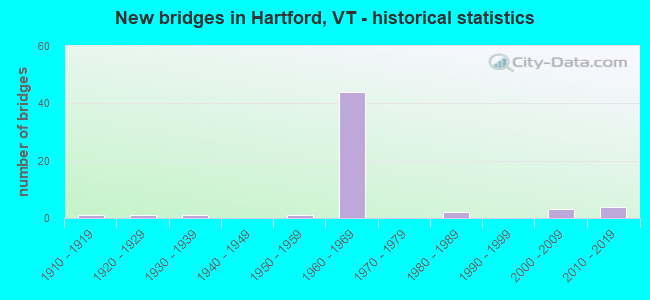
- New bridges - historical statistics
- 11910-1919
- 11920-1929
- 11930-1939
- 11950-1959
- 441960-1969
- 21980-1989
- 32000-2009
- 42010-2019

- Reconstructed bridges - Historical Statistics
- 21980-1989
- 11990-1999
- 12000-2009


- Bridge Condition - Deck
- 20.6%Very good
- 41.2%Good
- 29.4%Satisfactory
- 5.9%Fair
- 2.9%Poor

- Bridge Condition - Superstructure
- 26.5%Very good
- 41.2%Good
- 23.5%Satisfactory
- 2.9%Fair
- 5.9%Poor

- Bridge Condition - Substructure
- 17.6%Very good
- 23.5%Good
- 52.9%Satisfactory
- 5.9%Fair

- Bridge Condition - Channel
- 50.0%Very good
- 28.6%Good
- 21.4%Satisfactory
Find on map >> Show street view
Structure Number: 200091043N14082, Location: I 91 EXIT 11 (Lat: 43.645614, Lng: -72.337836), Route carried "under" structure: US 5, Year Built: 1966, Structure Length: 0. m, Average Daily Traffic: 11,950 (year 1998), Truck Traffic: 6%, Features Intersected: I 91 OVER US 5, Facility Carried by Structure: I 00091 ML
Minimum Vertical Clearance: 5.79m (19.00ft), Kilometerpoint: 0.000, Lanes on structure: 4, Material/Design: Steel, Design/Construction: Stringer/Multi-beam, Length of Maximum Span: 30.5m (100.1ft)
Find on map >> Show street view
Structure Number: 200091043S14082, Location: I 91 EXIT 11 (Lat: 43.645592, Lng: -72.338172), Route carried "under" structure: US 5, Year Built: 1966, Structure Length: 0. m, Average Daily Traffic: 11,950 (year 1998), Truck Traffic: 6%, Features Intersected: I 91 OVER US 5, Facility Carried by Structure: I 00091 ML
Minimum Vertical Clearance: 6.40m (21.00ft), Kilometerpoint: 0.000, Lanes on structure: 4, Material/Design: Steel, Design/Construction: Stringer/Multi-beam, Length of Maximum Span: 30.5m (100.1ft)
Find on map >> Show street view
Structure Number: 200091044N14082, Location: 1.0 MI S EXIT 12 (Lat: 43.654883, Lng: -72.330606), Route carried "under" structure: State highway 14, Year Built: 1967, Structure Length: 0. m, Average Daily Traffic: 4,600 (year 1998), Truck Traffic: 9%, Features Intersected: I 91 OVER VT.14, Facility Carried by Structure: I 00091 ML
Minimum Vertical Clearance: 19.20m (62.99ft), Kilometerpoint: 0.000, Lanes on structure: 4, Material/Design: Steel continuous, Design/Construction: Girder and Floorbeam System, Length of Maximum Span: 73.2m (240.2ft)
Find on map >> Show street view
Structure Number: 200091044N14082, Location: 1.0 MI S EXIT 12 (Lat: 43.654883, Lng: -72.330606), Route carried "under" structure: US 4, Year Built: 1967, Structure Length: 0. m, Average Daily Traffic: 4,500 (year 1998), Truck Traffic: 9%, Features Intersected: I 91 OVER U.S.4, Facility Carried by Structure: I 00091 ML
Minimum Vertical Clearance: 5.58m (18.31ft), Kilometerpoint: 101.335, Lanes on structure: 4, Material/Design: Steel continuous, Design/Construction: Girder and Floorbeam System, Length of Maximum Span: 73.2m (240.2ft)
Find on map >> Show street view
Structure Number: 200091044S14082, Location: 1.0 MI S EXIT 12 (Lat: 43.654925, Lng: -72.330864), Route carried "under" structure: US 4, Year Built: 1967, Structure Length: 0. m, Average Daily Traffic: 4,500 (year 1998), Truck Traffic: 9%, Features Intersected: I 91 OVER U.S.4, Facility Carried by Structure: I 00091 ML
Minimum Vertical Clearance: 5.46m (17.91ft), Kilometerpoint: 101.335, Lanes on structure: 4, Material/Design: Steel continuous, Design/Construction: Girder and Floorbeam System, Length of Maximum Span: 73.2m (240.2ft)
Find on map >> Show street view
Structure Number: 200091044S14082, Location: 1.0 MI S EXIT 12 (Lat: 43.654925, Lng: -72.330864), Route carried "under" structure: State highway 14, Year Built: 1967, Structure Length: 0. m, Average Daily Traffic: 4,400 (year 1998), Truck Traffic: 9%, Features Intersected: I 91 OVER VT.14, Facility Carried by Structure: I 00091 ML
Minimum Vertical Clearance: 19.20m (62.99ft), Kilometerpoint: 0.000, Lanes on structure: 4, Material/Design: Steel continuous, Design/Construction: Girder and Floorbeam System, Length of Maximum Span: 73.2m (240.2ft)
Find on map >> Show street view
Structure Number: 200091045N14082, Location: I 91 EXIT 12 (Lat: 43.666369, Lng: -72.318972), Route carried "under" structure: Spur State highway 987, Year Built: 1967, Structure Length: 0. m, Average Daily Traffic: 3,900 (year 1996), Truck Traffic: 9%, Features Intersected: I 91 OVER WILDER S.H., Facility Carried by Structure: I 00091 ML
Minimum Vertical Clearance: 5.18m (16.99ft), Kilometerpoint: 0.000, Lanes on structure: 2, Material/Design: Steel continuous, Design/Construction: Stringer/Multi-beam, Length of Maximum Span: 20.7m (67.9ft)
Find on map >> Show street view
Structure Number: 200091045S14082, Location: I 91 EXIT 12 (Lat: 43.666469, Lng: -72.319228), Route carried "under" structure: Spur State highway 987, Year Built: 1967, Structure Length: 0. m, Average Daily Traffic: 3,900 (year 1996), Truck Traffic: 9%, Features Intersected: I 91 OVER WILDER S.H., Facility Carried by Structure: I 00091 ML
Minimum Vertical Clearance: 4.87m (15.98ft), Kilometerpoint: 0.000, Lanes on structure: 2, Material/Design: Steel continuous, Design/Construction: Stringer/Multi-beam, Length of Maximum Span: 20.7m (67.9ft)
Find on map >> Show street view
Structure Number: 200091047N14082, Location: 1.1 MI N EXIT 12 (Lat: 43.682214, Lng: -72.315167), Route carried "under" structure: US 5, Year Built: 1967, Structure Length: 0. m, Average Daily Traffic: 3,400 (year 1998), Truck Traffic: 6%, Features Intersected: I 91 OVER US 5, Facility Carried by Structure: I 00091 ML
Minimum Vertical Clearance: 5.38m (17.65ft), Kilometerpoint: 0.000, Lanes on structure: 2, Material/Design: Steel continuous, Design/Construction: Stringer/Multi-beam, Length of Maximum Span: 27.4m (89.9ft)
Find on map >> Show street view
Structure Number: 200091047S14082, Location: 1.1 MI N EXIT 12 (Lat: 43.682350, Lng: -72.315397), Route carried "under" structure: US 5, Year Built: 1967, Structure Length: 0. m, Average Daily Traffic: 3,400 (year 1998), Truck Traffic: 6%, Features Intersected: I 91 OVER US 5, Facility Carried by Structure: I 00091 ML
Minimum Vertical Clearance: 4.41m (14.47ft), Kilometerpoint: 0.000, Lanes on structure: 2, Material/Design: Steel continuous, Design/Construction: Stringer/Multi-beam, Length of Maximum Span: 27.4m (89.9ft)
Find on map >> Show street view
Structure Number: 2000910D4014082, Location: 2.0 MI S I91-I89 INTERCHG (Lat: 43.612225, Lng: -72.345183), Route carried "under" structure: Interstate 91, Year Built: 2008, Structure Length: 0. m, Average Daily Traffic: 800 (year 2008), Truck Traffic: 90%, Features Intersected: PRIVATE ROAD OVER I91, Facility Carried by Structure: QUARRY ROAD
Minimum Vertical Clearance: 5.79m (19.00ft), Kilometerpoint: 115.173, Lanes on structure: 2, Material/Design: Steel, Design/Construction: Stringer/Multi-beam, Length of Maximum Span: 50.0m (164.0ft)
Find on map >> Show street view
Structure Number: 200147000514082, Location: 4.4 MI N JCT. U.S.4 (Lat: 43.681331, Lng: -72.394667), Route carried "under" structure: State highway 14, Year Built: 1935, Structure Length: 0. m, Average Daily Traffic: 2,900 (year 1998), Truck Traffic: 6%, Features Intersected: N.E.C.R.R. OVER VT 14, Facility Carried by Structure: RAILROAD
Kilometerpoint: 0.000, Material/Design: Steel, Design/Construction: Stringer/Multi-beam, Length of Maximum Span: 30.5m (100.1ft)
Find on map >> Show street view
Structure Number: 2014080D1014081, Location: 2.8 MI N EXIT 1A (Lat: 43.699928, Lng: -72.409911), Route carried "under" structure: Interstate 89, Year Built: 1967, Structure Length: 0. m, Average Daily Traffic: 15,100 (year 1998), Truck Traffic: 2%, Features Intersected: I 89 UNDER TH NO 36, Facility Carried by Structure: TR 0TH36
Minimum Vertical Clearance: 5.48m (17.98ft), Kilometerpoint: 16.930, Lanes on structure: 2, Material/Design: Steel continuous, Design/Construction: Stringer/Multi-beam, Length of Maximum Span: 30.5m (100.1ft)
Find on map >> Show street view
Structure Number: 2014080D4614081, Location: 0.5 MI N EXIT 12 (Lat: 43.672794, Lng: -72.318125), Route carried "under" structure: Interstate 91, Year Built: 1967, Structure Length: 0. m, Average Daily Traffic: 17,400 (year 1998), Truck Traffic: 13%, Features Intersected: I 91 UNDER TH NO 33, Facility Carried by Structure: TR 0TH33
Minimum Vertical Clearance: 5.00m (16.40ft), Kilometerpoint: 116.588, Lanes on structure: 2, Material/Design: Steel, Design/Construction: Stringer/Multi-beam, Length of Maximum Span: 32.0m (105.0ft)