Bridge Statistics for Hastings, Nebraska (NE)
Condition, Traffic, Stress, Structural Evaluation, Project Costs
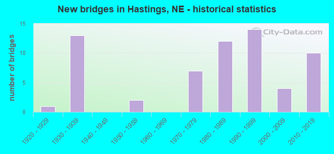
- New bridges - historical statistics
- 11920-1929
- 131930-1939
- 21950-1959
- 71970-1979
- 121980-1989
- 141990-1999
- 42000-2009
- 102010-2019
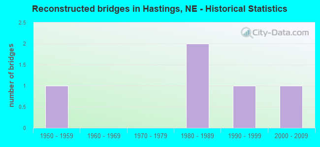
- Reconstructed bridges - Historical Statistics
- 11950-1959
- 01960-1969
- 01970-1979
- 21980-1989
- 11990-1999
- 12000-2009
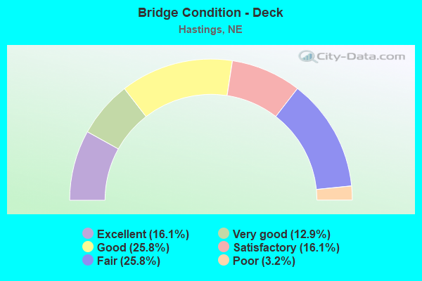
- Bridge Condition - Deck
- 16.1%Excellent
- 12.9%Very good
- 25.8%Good
- 16.1%Satisfactory
- 25.8%Fair
- 3.2%Poor
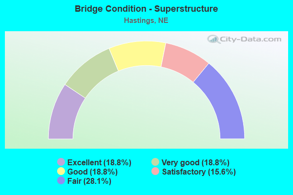
- Bridge Condition - Superstructure
- 18.8%Excellent
- 18.8%Very good
- 18.8%Good
- 15.6%Satisfactory
- 28.1%Fair
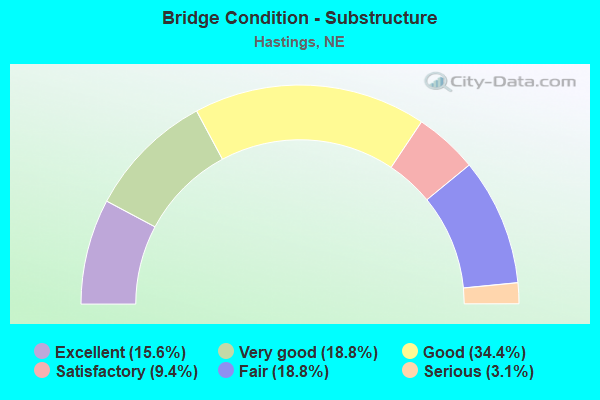
- Bridge Condition - Substructure
- 15.6%Excellent
- 18.8%Very good
- 34.4%Good
- 9.4%Satisfactory
- 18.8%Fair
- 3.1%Serious
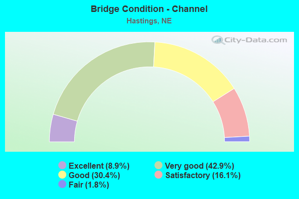
- Bridge Condition - Channel
- 8.9%Excellent
- 42.9%Very good
- 30.4%Good
- 16.1%Satisfactory
- 1.8%Fair
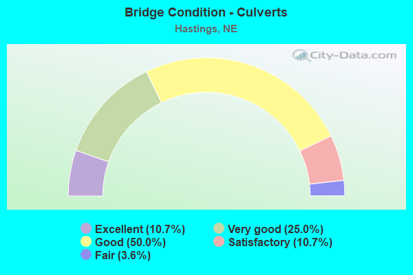
- Bridge Condition - Culverts
- 10.7%Excellent
- 25.0%Very good
- 50.0%Good
- 10.7%Satisfactory
- 3.6%Fair
Find on map >> Show street view
Structure Number: S034 21606, Location: 5N HASTINGS (Lat: 40.671200, Lng: -98.382000), Route carried "on" structure: US 34, Year Built: 1983, Status: Open, Structure Length: 1.74m (5.71ft), Average Daily Traffic: 14,855 (year 2018), Truck Traffic: 10%, Average Future Daily Traffic: 23,768 (year 2038), Features Intersected: STREAM
Minimum Vertical Clearance: 30+ m (98+ ft), Kilometerpoint: 34.771, Lanes on structure: 2, Base Highway Network: Yes, Owner: State Highway Agency, Approaching Roadway Width: 21.9m (71.9ft), Skew: 3 degrees, Material/Design: Concrete, Design/Construction: Culvert, Number Of Spans In Main Unit: 4, Length of Maximum Span: 3.7m (12.1ft)
Condition: Channel: Very good, Culverts: Good, Operating Rating: 33.0 metric tons, Method Used To Determine Operating Rating: Field evaluation and documented engineering judgment, Inventory Rating: 22.0 metric tons, Method Used To Determine Inventory Rating: Field evaluation and documented engineering judgment, Structural Evaluation: Somewhat better than minimum adequacy, Waterway Adequacy: Equal to present desirable criteria, Approach Roadway Alignment: Equal to present desirable criteria, Designated Inspection Frequency: Every 24 months, Inspection Date: August 2021
Find on map >> Show street view
Structure Number: S281 04402, Location: 1S HASTINGS (Lat: 40.559400, Lng: -98.402000), Route carried "on" structure: US 281, Year Built: 1995, Status: Open, Structure Length: 3.14m (10.30ft), Average Daily Traffic: 3,155 (year 2018), Truck Traffic: 12%, Average Future Daily Traffic: 4,102 (year 2038), Design Load: HS 25 or greater, Features Intersected: PAWNEE CREEK
Minimum Vertical Clearance: 30+ m (98+ ft), Kilometerpoint: 7.084, Lanes on structure: 2, Base Highway Network: Yes, Owner: State Highway Agency, Approaching Roadway Width: 12.2m (40.0ft), Material/Design: Concrete continuous, Design/Construction: Slab, Number Of Spans In Main Unit: 3, Length of Maximum Span: 12.2m (40.0ft), Curb-To-Curb Width: 13.4m (44.0ft), Out-to-Out Width: 14.1m (46.3ft)
Condition: Deck: Very good, Superstructure: Very good, Substructure: Very good, Channel: Very good, Operating Rating: 59.0 metric tons, Method Used To Determine Operating Rating: Load Factor (LF), Inventory Rating: 35.0 metric tons, Method Used To Determine Inventory Rating: Load Factor (LF), Structural Evaluation: Equal to present desirable criteria, Deck Geometry: Better than present minimum criteria, Waterway Adequacy: Equal to present desirable criteria, Approach Roadway Alignment: Equal to present desirable criteria, Designated Inspection Frequency: Every 48 months, Inspection Date: August 2019, Deck Structure Type: Concrete Cast-file-Place, Wearing Surface/Protective System: Wearing Surface: Monolithic Concrete, Deck Protection: Epoxy Coated Reinforcing
Find on map >> Show street view
Structure Number: S281 04411, Location: 1S HASTINGS (Lat: 40.560500, Lng: -98.402000), Route carried "on" structure: US 281, Year Built: 1995, Status: Open, Structure Length: 0.82m (2.69ft), Average Daily Traffic: 3,155 (year 2018), Truck Traffic: 12%, Average Future Daily Traffic: 4,102 (year 2038), Design Load: HS 20, Features Intersected: PAWNEE CREEK
Minimum Vertical Clearance: 30+ m (98+ ft), Kilometerpoint: 7.099, Lanes on structure: 2, Base Highway Network: Yes, Owner: State Highway Agency, Approaching Roadway Width: 12.2m (40.0ft), Material/Design: Concrete, Design/Construction: Culvert, Number Of Spans In Main Unit: 3, Length of Maximum Span: 2.4m (7.9ft)
Condition: Channel: Very good, Culverts: Good, Operating Rating: 43.0 metric tons, Method Used To Determine Operating Rating: Field evaluation and documented engineering judgment, Inventory Rating: 33.0 metric tons, Method Used To Determine Inventory Rating: Field evaluation and documented engineering judgment, Structural Evaluation: Better than present minimum criteria, Waterway Adequacy: Equal to present desirable criteria, Approach Roadway Alignment: Equal to present desirable criteria, Designated Inspection Frequency: Every 48 months, Inspection Date: August 2019
Find on map >> Show street view
Structure Number: SS01C0003, Location: 1S HASTINGS REGIONAL CNTR (Lat: 40.572300, Lng: -98.439900), Route carried "on" structure: Spur State highway S01C, Year Built: 1974, Status: Open, Structure Length: 2.04m (6.69ft), Average Daily Traffic: 1,110 (year 2018), Truck Traffic: 9%, Average Future Daily Traffic: 1,776 (year 2038), Features Intersected: PAWNEE CREEK, Facility Carried by Structure: S1C REGIONAL CENTR
Minimum Vertical Clearance: 30+ m (98+ ft), Kilometerpoint: 0.048, Lanes on structure: 2, Owner: State Highway Agency, Approaching Roadway Width: 7.3m (24.0ft), Material/Design: Prestressed concrete, Design/Construction: Tee Beam, Number Of Spans In Main Unit: 3, Length of Maximum Span: 7.9m (25.9ft), Curb or Sidewalk Widths: Left: 0.2m (0.7ft), Right: 0.2m (0.7ft), Curb-To-Curb Width: 12.3m (40.4ft), Out-to-Out Width: 13.2m (43.3ft)
Condition: Deck: Poor, Superstructure: Good, Substructure: Good, Channel: Good, Operating Rating: 46.0 metric tons, Method Used To Determine Operating Rating: Load Factor (LF), Inventory Rating: 28.0 metric tons, Method Used To Determine Inventory Rating: Load Factor (LF), Structural Evaluation: Better than present minimum criteria, Deck Geometry: Better than present minimum criteria, Waterway Adequacy: Better than present minimum criteria, Approach Roadway Alignment: Equal to present desirable criteria, Designated Inspection Frequency: Every 24 months, Inspection Date: August 2021, Deck Structure Type: Concrete Cast-file-Place, Wearing Surface/Protective System: Wearing Surface: Bituminous
Find on map >> Show street view
Structure Number: SS01D00152, Location: 4W TRUMBULL (Lat: 40.684000, Lng: -98.352500), Route carried "on" structure: Spur State highway S01D, Year Built: 1976, Year Reconstructed: 1999, Status: Open, Structure Length: 0.73m (2.40ft), Average Daily Traffic: 635 (year 2018), Truck Traffic: 10%, Average Future Daily Traffic: 953 (year 2038), Design Load: HS 20, Features Intersected: TRIB TO FLAT CREEK, Facility Carried by Structure: S1D TRUMBULL SPUR
Minimum Vertical Clearance: 30+ m (98+ ft), Kilometerpoint: 0.245, Lanes on structure: 2, Owner: State Highway Agency, Approaching Roadway Width: 7.3m (24.0ft), Material/Design: Concrete, Design/Construction: Culvert, Number Of Spans In Main Unit: 3, Length of Maximum Span: 2.4m (7.9ft)
Condition: Channel: Very good, Culverts: Very good, Operating Rating: 33.0 metric tons, Method Used To Determine Operating Rating: Field evaluation and documented engineering judgment, Inventory Rating: 22.0 metric tons, Method Used To Determine Inventory Rating: Field evaluation and documented engineering judgment, Structural Evaluation: Somewhat better than minimum adequacy, Waterway Adequacy: Equal to present minimum criteria, Approach Roadway Alignment: Equal to present desirable criteria, Designated Inspection Frequency: Every 24 months, Inspection Date: August 2021
Find on map >> Show street view
Structure Number: U114501645, Location: HASTINGS 12TH STREET EAST (Lat: 40.597100, Lng: -98.371800), Route carried "on" structure: City street 160, Year Built: 2014, Status: Open, Structure Length: 0.69m (2.26ft), Average Daily Traffic: 50 (year 2003), Average Future Daily Traffic: 70 (year 2033), Design Load: HL 93, Features Intersected: LAKE SPILLWAY STREAM, Facility Carried by Structure: EAST 12TH STREET
Minimum Vertical Clearance: 30+ m (98+ ft), Kilometerpoint: 0.000, Lanes on structure: 3, Owner: City or Municipal Highway Agency, Approaching Roadway Width: 11.6m (38.1ft), Skew: 2 degrees, Material/Design: Concrete, Design/Construction: Culvert, Number Of Spans In Main Unit: 2, Length of Maximum Span: 3.4m (11.2ft), Curb or Sidewalk Widths: Left: 1.8m (5.9ft), Right: 1.8m (5.9ft)
Condition: Channel: Excellent, Culverts: Very good, Operating Rating: 60.0 metric tons, Method Used To Determine Operating Rating: Load and Resistance Factor (LRFR), Inventory Rating: 46.0 metric tons, Method Used To Determine Inventory Rating: Load and Resistance Factor (LRFR), Structural Evaluation: Equal to present desirable criteria, Waterway Adequacy: Superior to present desirable criteria, Approach Roadway Alignment: Superior to present desirable criteria, Designated Inspection Frequency: Every 24 months, Inspection Date: November 2020
Find on map >> Show street view
Structure Number: U11451353, Location: 2135 N. BALTIMORE AVE (Lat: 40.606900, Lng: -98.401600), Route carried "on" structure: City street 5505, Year Built: 1986, Status: Open, Structure Length: 1.01m (3.31ft), Average Daily Traffic: 3,790 (year 2012), Truck Traffic: 7%, Average Future Daily Traffic: 3,475 (year 2033), Design Load: HS 20, Features Intersected: BLUE BLUE R W FK TRIB, Facility Carried by Structure: BALTIMORE AVE
Minimum Vertical Clearance: 30+ m (98+ ft), Kilometerpoint: 16.528, Lanes on structure: 2, Owner: City or Municipal Highway Agency, Approaching Roadway Width: 10.7m (35.1ft), Skew: 1 degrees, Material/Design: Concrete, Design/Construction: Culvert, Number Of Spans In Main Unit: 3, Length of Maximum Span: 3.2m (10.5ft), Curb or Sidewalk Widths: Left: 3.0m (9.8ft), Right: 0.0m
Condition: Channel: Good, Culverts: Good, Operating Rating: 33.0 metric tons, Method Used To Determine Operating Rating: Field evaluation and documented engineering judgment, Inventory Rating: 22.0 metric tons, Method Used To Determine Inventory Rating: Field evaluation and documented engineering judgment, Structural Evaluation: Somewhat better than minimum adequacy, Waterway Adequacy: Equal to present desirable criteria, Approach Roadway Alignment: Superior to present desirable criteria, Designated Inspection Frequency: Every 24 months, Inspection Date: November 2020
Find on map >> Show street view
Structure Number: U114553905, Location: ELM AVE. N. OF 14TH (Lat: 40.602900, Lng: -98.373700), Route carried "on" structure: City street 5515, Year Built: 1993, Status: Open, Structure Length: 6.19m (20.31ft), Average Daily Traffic: 2,190 (year 2012), Truck Traffic: 2%, Average Future Daily Traffic: 2,200 (year 2033), Design Load: HS 25 or greater, Features Intersected: UPRR 813-897-G, Facility Carried by Structure: ELM AVE
Minimum Vertical Clearance: 30+ m (98+ ft), Kilometerpoint: 16.338, Lanes on structure: 2, Owner: City or Municipal Highway Agency, Approaching Roadway Width: 10.7m (35.1ft), Material/Design: Prestressed concrete, Design/Construction: Stringer/Multi-beam, Number Of Spans In Main Unit: 3, Length of Maximum Span: 25.3m (83.0ft), Curb or Sidewalk Widths: Left: 1.5m (4.9ft), Right: 1.5m (4.9ft), Curb-To-Curb Width: 11.0m (36.1ft), Out-to-Out Width: 15.5m (50.9ft)
Condition: Deck: Good, Superstructure: Very good, Substructure: Very good, Operating Rating: 73.0 metric tons, Method Used To Determine Operating Rating: Load Factor (LF), Inventory Rating: 40.0 metric tons, Method Used To Determine Inventory Rating: Load Factor (LF), Structural Evaluation: Equal to present desirable criteria, Deck Geometry: Somewhat better than minimum adequacy, Underclear: Better than present minimum criteria, Approach Roadway Alignment: Equal to present desirable criteria, Designated Inspection Frequency: Every 24 months, Inspection Date: November 2020, Deck Structure Type: Concrete Cast-file-Place, Wearing Surface/Protective System: Wearing Surface: Monolithic Concrete, Deck Protection: Epoxy Coated Reinforcing
Find on map >> Show street view
Structure Number: U1145A3705, Location: HASTINGS EASTSIDE@FOREST (Lat: 40.595100, Lng: -98.382400), Route carried "on" structure: City street 5509, Year Built: 1930, Status: Open, Structure Length: 0.85m (2.79ft), Average Daily Traffic: 2,695 (year 2012), Truck Traffic: 2%, Average Future Daily Traffic: 2,780 (year 2033), Features Intersected: BIG BLUE R W FK TRIB, Facility Carried by Structure: EASTSIDE BLVD
Minimum Vertical Clearance: 30+ m (98+ ft), Kilometerpoint: 16.204, Lanes on structure: 2, Owner: City or Municipal Highway Agency, Approaching Roadway Width: 9.0m (29.5ft), Material/Design: Concrete, Design/Construction: Stringer/Multi-beam, Number Of Spans In Main Unit: 1, Length of Maximum Span: 7.6m (24.9ft), Curb or Sidewalk Widths: Left: 0.6m (2.0ft), Right: 2.0m (6.6ft), Curb-To-Curb Width: 9.0m (29.5ft), Out-to-Out Width: 11.7m (38.4ft)
Condition: Deck: Fair, Superstructure: Fair, Substructure: Fair, Channel: Satisfactory, Operating Rating: 33.0 metric tons, Method Used To Determine Operating Rating: Field evaluation and documented engineering judgment, Inventory Rating: 22.0 metric tons, Method Used To Determine Inventory Rating: Field evaluation and documented engineering judgment, Structural Evaluation: Somewhat better than minimum adequacy, Deck Geometry: Meets minimum limits, Waterway Adequacy: Equal to present desirable criteria, Approach Roadway Alignment: Equal to present desirable criteria, Designated Inspection Frequency: Every 24 months, Inspection Date: November 2020, Deck Structure Type: Concrete Cast-file-Place, Wearing Surface/Protective System: Wearing Surface: Bituminous
Find on map >> Show street view
Structure Number: U1145B3505, Location: HASTINGS S SHOR@BALTIMORE (Lat: 40.608300, Lng: -98.399900), Route carried "on" structure: City street B35, Year Built: 1982, Status: Open, Structure Length: 1.43m (4.69ft), Average Daily Traffic: 445 (year 2003), Truck Traffic: 10%, Average Future Daily Traffic: 623 (year 2033), Features Intersected: BIG BLUE R W FK TRIB, Facility Carried by Structure: SOUTH SHORE DR
Minimum Vertical Clearance: 30+ m (98+ ft), Kilometerpoint: 0.000, Lanes on structure: 2, Owner: City or Municipal Highway Agency, Approaching Roadway Width: 7.3m (24.0ft), Skew: 2 degrees, Material/Design: Concrete continuous, Design/Construction: Slab, Number Of Spans In Main Unit: 2, Length of Maximum Span: 7.0m (23.0ft), Curb-To-Curb Width: 8.5m (27.9ft), Out-to-Out Width: 9.3m (30.5ft)
Condition: Deck: Satisfactory, Superstructure: Satisfactory, Substructure: Good, Channel: Satisfactory, Operating Rating: 73.0 metric tons, Method Used To Determine Operating Rating: Load Factor (LF), Inventory Rating: 44.0 metric tons, Method Used To Determine Inventory Rating: Load Factor (LF), Structural Evaluation: Equal to present minimum criteria, Deck Geometry: Somewhat better than minimum adequacy, Waterway Adequacy: Equal to present desirable criteria, Approach Roadway Alignment: Equal to present desirable criteria, Designated Inspection Frequency: Every 24 months, Inspection Date: November 2020, Deck Structure Type: Concrete Cast-file-Place, Wearing Surface/Protective System: Wearing Surface: Monolithic Concrete
Find on map >> Show street view
Structure Number: U1145C2015, Location: HASTINGS HASTINGS AVE @ H (Lat: 40.571700, Lng: -98.390000), Route carried "on" structure: City street C20, Year Built: 1999, Status: Open, Structure Length: 1.10m (3.61ft), Average Daily Traffic: 50 (year 1997), Average Future Daily Traffic: 110 (year 2033), Design Load: HS 20, Features Intersected: PAWNEE CREEK TRIB, Facility Carried by Structure: HASTINGS AVE H ST
Minimum Vertical Clearance: 30+ m (98+ ft), Kilometerpoint: 0.000, Lanes on structure: 2, Owner: City or Municipal Highway Agency, Approaching Roadway Width: 8.5m (27.9ft), Skew: 4 degrees, Material/Design: Concrete, Design/Construction: Culvert, Number Of Spans In Main Unit: 3, Length of Maximum Span: 3.4m (11.2ft)
Condition: Channel: Good, Culverts: Good, Operating Rating: 33.0 metric tons, Method Used To Determine Operating Rating: Field evaluation and documented engineering judgment, Inventory Rating: 22.0 metric tons, Method Used To Determine Inventory Rating: Field evaluation and documented engineering judgment, Structural Evaluation: Equal to present minimum criteria, Waterway Adequacy: Equal to present desirable criteria, Approach Roadway Alignment: Superior to present desirable criteria, Designated Inspection Frequency: Every 24 months, Inspection Date: November 2020
Find on map >> Show street view
Structure Number: U1145D372, Location: HASTINGS CALIF @ LAKESIDE (Lat: 40.595300, Lng: -98.378200), Route carried "on" structure: City street D37, Year Built: 1991, Status: Open, Structure Length: 0.82m (2.69ft), Average Daily Traffic: 50 (year 2003), Average Future Daily Traffic: 70 (year 2033), Design Load: HS 20, Features Intersected: BIG BLUE R W FK TRIB, Facility Carried by Structure: CALIFORNIA AVE
Minimum Vertical Clearance: 30+ m (98+ ft), Kilometerpoint: 0.000, Lanes on structure: 2, Owner: City or Municipal Highway Agency, Approaching Roadway Width: 8.5m (27.9ft), Material/Design: Concrete, Design/Construction: Culvert, Number Of Spans In Main Unit: 3, Length of Maximum Span: 2.7m (8.9ft), Curb or Sidewalk Widths: Left: 1.2m (3.9ft), Right: 1.2m (3.9ft)
Condition: Channel: Very good, Culverts: Satisfactory, Operating Rating: 33.0 metric tons, Method Used To Determine Operating Rating: Field evaluation and documented engineering judgment, Inventory Rating: 22.0 metric tons, Method Used To Determine Inventory Rating: Field evaluation and documented engineering judgment, Structural Evaluation: Equal to present minimum criteria, Waterway Adequacy: Superior to present desirable criteria, Approach Roadway Alignment: Equal to present desirable criteria, Designated Inspection Frequency: Every 24 months, Inspection Date: November 2020
Find on map >> Show street view
Structure Number: U1145G3305, Location: HASTINGS CRANE @ 14TH (Lat: 40.601600, Lng: -98.411000), Route carried "on" structure: City street G33, Year Built: 1974, Status: Open, Structure Length: 0.85m (2.79ft), Average Daily Traffic: 819 (year 2003), Truck Traffic: 10%, Average Future Daily Traffic: 1,146 (year 2033), Design Load: H 20, Features Intersected: BIG BLUE R W FK TRIB, Facility Carried by Structure: CRANE AVE
Minimum Vertical Clearance: 30+ m (98+ ft), Kilometerpoint: 0.000, Lanes on structure: 2, Owner: City or Municipal Highway Agency, Approaching Roadway Width: 15.5m (50.9ft), Material/Design: Concrete, Design/Construction: Culvert, Number Of Spans In Main Unit: 4, Length of Maximum Span: 1.8m (5.9ft), Curb or Sidewalk Widths: Left: 0.0m, Right: 1.2m (3.9ft)
Condition: Channel: Good, Culverts: Good, Operating Rating: 33.0 metric tons, Method Used To Determine Operating Rating: Field evaluation and documented engineering judgment, Inventory Rating: 22.0 metric tons, Method Used To Determine Inventory Rating: Field evaluation and documented engineering judgment, Structural Evaluation: Somewhat better than minimum adequacy, Waterway Adequacy: Better than present minimum criteria, Approach Roadway Alignment: Superior to present desirable criteria, Designated Inspection Frequency: Every 24 months, Inspection Date: November 2020
Find on map >> Show street view
Structure Number: U1145J3305, Location: HASTINGS HERTIGE@WESTCHTR (Lat: 40.602500, Lng: -98.407400), Route carried "on" structure: City street J33, Year Built: 1989, Status: Open, Structure Length: 1.10m (3.61ft), Average Daily Traffic: 344 (year 2003), Truck Traffic: 10%, Average Future Daily Traffic: 481 (year 2033), Design Load: HS 20, Features Intersected: BIG BLUE R W FK TRIB, Facility Carried by Structure: HERITAGE DR
Minimum Vertical Clearance: 30+ m (98+ ft), Kilometerpoint: 0.000, Lanes on structure: 2, Owner: City or Municipal Highway Agency, Approaching Roadway Width: 11.0m (36.1ft), Material/Design: Concrete, Design/Construction: Culvert, Number Of Spans In Main Unit: 3, Length of Maximum Span: 3.7m (12.1ft), Curb or Sidewalk Widths: Left: 2.4m (7.9ft), Right: 2.4m (7.9ft)
Condition: Channel: Very good, Culverts: Satisfactory, Operating Rating: 33.0 metric tons, Method Used To Determine Operating Rating: Field evaluation and documented engineering judgment, Inventory Rating: 22.0 metric tons, Method Used To Determine Inventory Rating: Field evaluation and documented engineering judgment, Structural Evaluation: Equal to present minimum criteria, Waterway Adequacy: Superior to present desirable criteria, Approach Roadway Alignment: Superior to present desirable criteria, Designated Inspection Frequency: Every 24 months, Inspection Date: November 2020, Deck Structure Type: Concrete Cast-file-Place, Wearing Surface/Protective System: Wearing Surface: Monolithic Concrete
Find on map >> Show street view
Structure Number: U1145M3505, Location: HASTINGS 16TH @ KANSAS AV (Lat: 40.603000, Lng: -98.385000), Route carried "on" structure: City street 5519, Year Built: 1935, Year Reconstructed: 1985, Status: Closed, Structure Length: 17.43m (57.19ft), Average Daily Traffic: 2,420 (year 2012), Average Future Daily Traffic: 2,365 (year 2033), Design Load: H 20, Features Intersected: KNSAS AVE/UPRR 814-729-E
Minimum Vertical Clearance: 30+ m (98+ ft), Kilometerpoint: 16.148, Lanes on structure: 2, Lanes under structure: 2, Owner: City or Municipal Highway Agency, Approaching Roadway Width: 12.8m (42.0ft), Skew: 2 degrees, Material/Design: Steel continuous, Design/Construction: Stringer/Multi-beam, Number Of Spans In Main Unit: 9, Length of Maximum Span: 22.9m (75.1ft), Curb or Sidewalk Widths: Left: 0.2m (0.7ft), Right: 0.2m (0.7ft), Curb-To-Curb Width: 7.9m (25.9ft), Out-to-Out Width: 8.7m (28.5ft)
Condition: Deck: Satisfactory, Superstructure: Satisfactory, Substructure: Serious, Deck Geometry: High priority of corrective action, Approach Roadway Alignment: Equal to present minimum criteria, Length Of Structure Improvement: 17.43m (57.19ft), Designated Inspection Frequency: Every 24 months, Inspection Date: November 2020, Deck Structure Type: Concrete Cast-file-Place, Wearing Surface/Protective System: Wearing Surface: Monolithic Concrete, Deck Protection: Epoxy Coated Reinforcing
Find on map >> Show street view
Structure Number: U1145N3505, Location: HASTINGS OSBORNE DR WEST (Lat: 40.612800, Lng: -98.383900), Route carried "on" structure: City street N38, Year Built: 1981, Status: Open, Structure Length: 1.05m (3.44ft), Average Daily Traffic: 510 (year 2003), Truck Traffic: 10%, Average Future Daily Traffic: 714 (year 2033), Design Load: HS 20, Features Intersected: BIG BLUE R W FK TRIB, Facility Carried by Structure: OSBORNE DR WEST
Minimum Vertical Clearance: 30+ m (98+ ft), Kilometerpoint: 0.000, Lanes on structure: 2, Owner: City or Municipal Highway Agency, Approaching Roadway Width: 12.8m (42.0ft), Skew: 3 degrees, Material/Design: Concrete, Design/Construction: Culvert, Number Of Spans In Main Unit: 3, Length of Maximum Span: 3.3m (10.8ft), Curb or Sidewalk Widths: Left: 2.4m (7.9ft), Right: 0.0m
Condition: Channel: Very good, Culverts: Good, Operating Rating: 33.0 metric tons, Method Used To Determine Operating Rating: Field evaluation and documented engineering judgment, Inventory Rating: 22.0 metric tons, Method Used To Determine Inventory Rating: Field evaluation and documented engineering judgment, Structural Evaluation: Somewhat better than minimum adequacy, Waterway Adequacy: Superior to present desirable criteria, Approach Roadway Alignment: Superior to present desirable criteria, Designated Inspection Frequency: Every 24 months, Inspection Date: November 2020
Find on map >> Show street view
Structure Number: S006 21533, Location: 1E HASTINGS (Lat: 40.582500, Lng: -98.344600), Route carried "under" structure: US 6, Year Built: 1992, Structure Length: 0. m, Average Daily Traffic: 8,405 (year 2008), Truck Traffic: 11%, Features Intersected: UPRR 813-894-L, Facility Carried by Structure: UPRR
Minimum Vertical Clearance: 6.42m (21.06ft), Kilometerpoint: 34.654, Lanes under structure: 2, Material/Design: Steel, Design/Construction: Stringer/Multi-beam, Length of Maximum Span: 23.5m (77.1ft)
Find on map >> Show street view
Structure Number: S034 20967, Location: IN HASTINGS (Lat: 40.583600, Lng: -98.392400), Route carried "under" structure: US 34, Year Built: 1995, Structure Length: 0. m, Average Daily Traffic: 22,540 (year 2008), Truck Traffic: 7%, Features Intersected: BNSF RR 083-171-E, Facility Carried by Structure: BNSF RR
Minimum Vertical Clearance: 4.87m (15.98ft), Kilometerpoint: 33.743, Lanes on structure: 4, Lanes under structure: 4, Material/Design: Steel continuous, Design/Construction: Stringer/Multi-beam, Length of Maximum Span: 14.3m (46.9ft)
Find on map >> Show street view
Structure Number: U1145M3505, Location: HASTINGS 16TH @ KANSAS AV (Lat: 40.603000, Lng: -98.385000), Route carried "under" structure: City street M35, Year Built: 1935, Structure Length: 0. m, Average Daily Traffic: 150 (year 1997), Truck Traffic: 10%, Features Intersected: KNSAS AVE/UPRR 814-729-E, Facility Carried by Structure: 16TH ST FAU 5519
Minimum Vertical Clearance: 7.03m (23.06ft), Kilometerpoint: 0.000, Lanes on structure: 2, Lanes under structure: 2, Material/Design: Steel continuous, Design/Construction: Stringer/Multi-beam, Length of Maximum Span: 22.9m (75.1ft)