Bridge Statistics for Hooker, Oklahoma (OK)
Condition, Traffic, Stress, Structural Evaluation, Project Costs
- National Bridge Inventory (NBI) Statistics
- 157Number of bridges
- 912ft / 278mTotal length
- $96,665,000Total costs
- 193,461Total average daily traffic
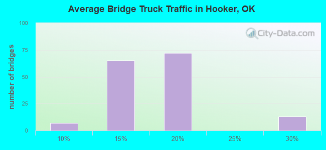
- 30,455Total average daily truck traffic
- 309,520Total future (year 2040) average daily traffic
- National Bridge Inventory (NBI) Registered Bridges for Hooker
- No street view available for this location
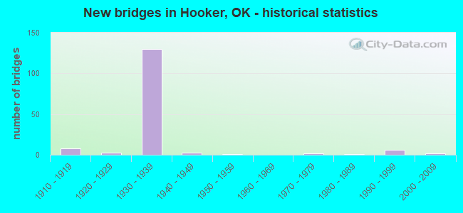
- New bridges - historical statistics
- 81910-1919
- 31920-1929
- 1301930-1939
- 31940-1949
- 11950-1959
- 21970-1979
- 11980-1989
- 61990-1999
- 22000-2009
- 12010-2019
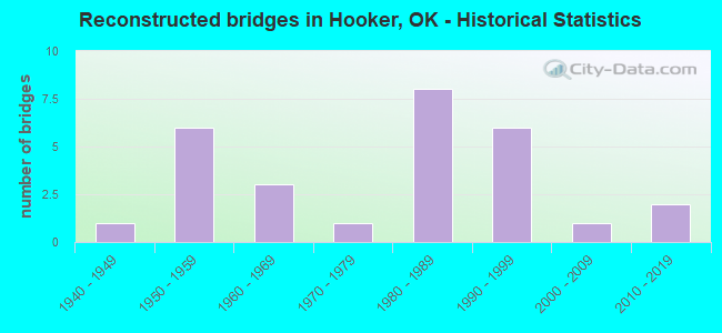
- Reconstructed bridges - Historical Statistics
- 11940-1949
- 61950-1959
- 31960-1969
- 11970-1979
- 81980-1989
- 61990-1999
- 12000-2009
- 22010-2019

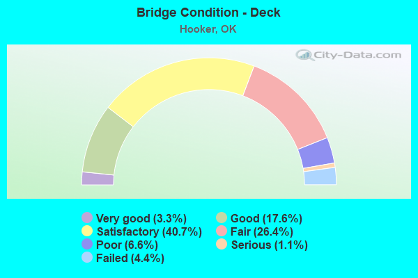
- Bridge Condition - Deck
- 3.3%Very good
- 17.6%Good
- 40.7%Satisfactory
- 26.4%Fair
- 6.6%Poor
- 1.1%Serious
- 4.4%Failed
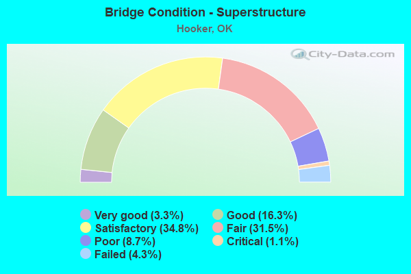
- Bridge Condition - Superstructure
- 3.3%Very good
- 16.3%Good
- 34.8%Satisfactory
- 31.5%Fair
- 8.7%Poor
- 1.1%Critical
- 4.3%Failed
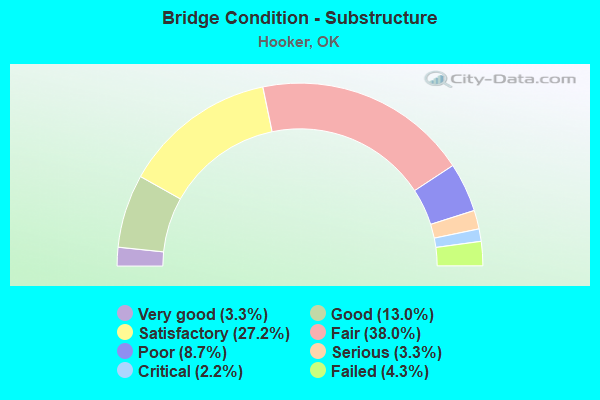
- Bridge Condition - Substructure
- 3.3%Very good
- 13.0%Good
- 27.2%Satisfactory
- 38.0%Fair
- 8.7%Poor
- 3.3%Serious
- 2.2%Critical
- 4.3%Failed
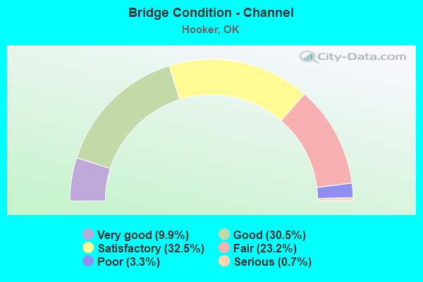
- Bridge Condition - Channel
- 9.9%Very good
- 30.5%Good
- 32.5%Satisfactory
- 23.2%Fair
- 3.3%Poor
- 0.7%Serious
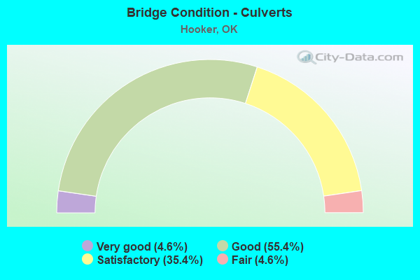
- Bridge Condition - Culverts
- 4.6%Very good
- 55.4%Good
- 35.4%Satisfactory
- 4.6%Fair
Find on map >> Show street view
Structure Number: 3662, Location: 2.5 WEST OF JENNINGS (Lat: 36.181589, Lng: -96.615017), Route carried "on" structure: County highway E0575, Year Built: 1932, Status: Posted for load, Structure Length: 1.37m (4.49ft), Average Daily Traffic: 150 (year 2020), Truck Traffic: 15%, Average Future Daily Traffic: 240 (year 2040), Features Intersected: KENNY CREEK
Minimum Vertical Clearance: 30+ m (98+ ft), Kilometerpoint: 3.138, Lanes on structure: 2, Owner: County Highway Agency, Approaching Roadway Width: 5.5m (18.0ft), Material/Design: Steel, Design/Construction: Stringer/Multi-beam, Number Of Spans In Main Unit: 1, Length of Maximum Span: 12.2m (40.0ft), Curb-To-Curb Width: 5.5m (18.0ft), Out-to-Out Width: 6.3m (20.7ft)
Condition: Deck: Satisfactory, Superstructure: Fair, Substructure: Fair, Channel: Fair, Operating Rating: 41.2 metric tons, Method Used To Determine Operating Rating: Load Factor (LF), Inventory Rating: 24.7 metric tons, Method Used To Determine Inventory Rating: Load Factor (LF), Structural Evaluation: Somewhat better than minimum adequacy, Waterway Adequacy: Equal to present minimum criteria, Approach Roadway Alignment: Equal to present desirable criteria, Bridge Posting: Required (Relationship of Operating Rating to Maximum Legal Load: 0.1 - 9.9% below), Length Of Structure Improvement: 4.08m (13.39ft), Designated Inspection Frequency: Every 24 months, Inspection Date: July 2021, Bridge Improvement Cost: $208,000, Roadway Improvement Cost: $115,000, Total Project Cost: $331,000 ( Estimate for 2015), Deck Structure Type: Concrete Cast-file-Place, Wearing Surface/Protective System: Wearing Surface: Monolithic Concrete
Find on map >> Show street view
Structure Number: 3665, Location: 1.8 E .9 N OF CLOUDY (Lat: 34.314444, Lng: -95.252672), Route carried "on" structure: County highway 6416C, Year Built: 1932, Status: Open, Structure Length: 1.22m (4.00ft), Average Daily Traffic: 100 (year 2020), Truck Traffic: 15%, Average Future Daily Traffic: 160 (year 2040), Design Load: H 10, Features Intersected: CREEK, Facility Carried by Structure: IRR FAS 6416
Minimum Vertical Clearance: 30+ m (98+ ft), Kilometerpoint: 3.058, Lanes on structure: 2, Owner: County Highway Agency, Approaching Roadway Width: 6.1m (20.0ft), Material/Design: Concrete, Design/Construction: Slab, Number Of Spans In Main Unit: 2, Length of Maximum Span: 5.2m (17.1ft), Curb-To-Curb Width: 6.1m (20.0ft), Out-to-Out Width: 6.7m (22.0ft)
Condition: Deck: Satisfactory, Superstructure: Satisfactory, Substructure: Good, Channel: Satisfactory, Operating Rating: 55.3 metric tons, Method Used To Determine Operating Rating: Load Factor (LF), Inventory Rating: 32.7 metric tons, Method Used To Determine Inventory Rating: Load Factor (LF), Structural Evaluation: Equal to present minimum criteria, Deck Geometry: Somewhat better than minimum adequacy, Waterway Adequacy: Equal to present minimum criteria, Approach Roadway Alignment: Equal to present desirable criteria, Length Of Structure Improvement: 3.83m (12.57ft), Designated Inspection Frequency: Every 24 months, Inspection Date: March 2020, Bridge Improvement Cost: $196,000, Roadway Improvement Cost: $108,000, Total Project Cost: $311,000 ( Estimate for 2015), Deck Structure Type: Concrete Cast-file-Place, Wearing Surface/Protective System: Wearing Surface: Bituminous
Find on map >> Show street view
Structure Number: 3667, Location: 1 MI N JCT U.S. 70 (Lat: 34.258467, Lng: -99.065125), Route carried "on" structure: US 183, Year Built: 1932, Year Reconstructed: 1976, Status: Open, Structure Length: 1.34m (4.40ft), Average Daily Traffic: 1,500 (year 2020), Truck Traffic: 16%, Average Future Daily Traffic: 2,400 (year 2040), Design Load: H 20, Features Intersected: CREEK
Minimum Vertical Clearance: 30+ m (98+ ft), Kilometerpoint: 1.529, Lanes on structure: 2, Base Highway Network: Yes, Owner: State Highway Agency, Approaching Roadway Width: 12.2m (40.0ft), Material/Design: Concrete, Design/Construction: Culvert, Number Of Spans In Main Unit: 4, Length of Maximum Span: 3.0m (9.8ft), Curb-To-Curb Width: 26.2m (86.0ft), Out-to-Out Width: 26.8m (87.9ft)
Condition: Channel: Good, Culverts: Good, Operating Rating: 50.3 metric tons, Method Used To Determine Operating Rating: Load Factor (LF), Inventory Rating: 30.2 metric tons, Method Used To Determine Inventory Rating: Load Factor (LF), Structural Evaluation: Better than present minimum criteria, Deck Geometry: Superior to present desirable criteria, Waterway Adequacy: Equal to present desirable criteria, Approach Roadway Alignment: Equal to present desirable criteria, Length Of Structure Improvement: 1.34m (4.40ft), Designated Inspection Frequency: Every 24 months, Inspection Date: April 2020, Bridge Improvement Cost: $230,000, Roadway Improvement Cost: $380,000, Total Project Cost: $644,000 ( Estimate for 2015)
Find on map >> Show street view
Structure Number: 3672, Location: 4.8 MI N JCT S.H. 33 (Lat: 35.910650, Lng: -98.583011), Route carried "on" structure: State highway 58, Year Built: 1932, Status: Open, Structure Length: 1.46m (4.79ft), Average Daily Traffic: 870 (year 2020), Truck Traffic: 15%, Average Future Daily Traffic: 1,392 (year 2040), Design Load: H 20, Features Intersected: CREEK
Minimum Vertical Clearance: 30+ m (98+ ft), Kilometerpoint: 7.707, Lanes on structure: 2, Owner: State Highway Agency, Approaching Roadway Width: 8.5m (27.9ft), Skew: 4 degrees, Material/Design: Concrete, Design/Construction: Culvert, Number Of Spans In Main Unit: 3, Length of Maximum Span: 3.0m (9.8ft), Curb-To-Curb Width: 14.0m (45.9ft), Out-to-Out Width: 14.6m (47.9ft)
Condition: Channel: Good, Culverts: Good, Operating Rating: 61.1 metric tons, Method Used To Determine Operating Rating: Load Factor (LF), Inventory Rating: 36.7 metric tons, Method Used To Determine Inventory Rating: Load Factor (LF), Structural Evaluation: Better than present minimum criteria, Deck Geometry: Superior to present desirable criteria, Waterway Adequacy: Equal to present minimum criteria, Approach Roadway Alignment: Equal to present desirable criteria, Length Of Structure Improvement: 1.46m (4.79ft), Designated Inspection Frequency: Every 24 months, Inspection Date: Febuary 2020, Bridge Improvement Cost: $230,000, Roadway Improvement Cost: $380,000, Total Project Cost: $644,000 ( Estimate for 2015)
Find on map >> Show street view
Structure Number: 3673, Location: 4.92 E JCT US-59 (Lat: 35.507061, Lng: -94.684611), Route carried "on" structure: State highway 101, Year Built: 1932, Status: Open, Structure Length: 1.31m (4.30ft), Average Daily Traffic: 580 (year 2020), Truck Traffic: 15%, Average Future Daily Traffic: 928 (year 2040), Design Load: H 15, Features Intersected: CEDAR CREEK
Minimum Vertical Clearance: 30+ m (98+ ft), Kilometerpoint: 12.740, Lanes on structure: 2, Owner: State Highway Agency, Approaching Roadway Width: 8.5m (27.9ft), Material/Design: Concrete, Design/Construction: Slab, Number Of Spans In Main Unit: 3, Length of Maximum Span: 3.7m (12.1ft), Curb or Sidewalk Widths: Left: 0.2m (0.7ft), Right: 0.2m (0.7ft), Curb-To-Curb Width: 7.4m (24.3ft), Out-to-Out Width: 7.9m (25.9ft)
Condition: Deck: Fair, Superstructure: Fair, Substructure: Fair, Channel: Satisfactory, Operating Rating: 44.5 metric tons, Method Used To Determine Operating Rating: Load Factor (LF), Inventory Rating: 32.7 metric tons, Method Used To Determine Inventory Rating: Load Factor (LF), Structural Evaluation: Somewhat better than minimum adequacy, Deck Geometry: Meets minimum limits, Waterway Adequacy: Better than present minimum criteria, Approach Roadway Alignment: Better than present minimum criteria, Length Of Structure Improvement: 3.98m (13.06ft), Designated Inspection Frequency: Every 24 months, Inspection Date: October 2021, Bridge Improvement Cost: $400,000, Roadway Improvement Cost: $660,000, Total Project Cost: $1,120,000 ( Estimate for 2015), Deck Structure Type: Concrete Cast-file-Place, Wearing Surface/Protective System: Wearing Surface: Bituminous
Find on map >> Show street view
Structure Number: 3674, Location: 4.8 MI NE JCT SH 3 (Lat: 36.722147, Lng: -101.413639), Route carried "on" structure: US 54, Year Built: 1932, Year Reconstructed: 1998, Status: Open, Structure Length: 1.31m (4.30ft), Average Daily Traffic: 7,500 (year 2020), Truck Traffic: 25%, Average Future Daily Traffic: 12,000 (year 2040), Design Load: H 20, Features Intersected: CREEK
Minimum Vertical Clearance: 30+ m (98+ ft), Kilometerpoint: 13.024, Lanes on structure: 4, Base Highway Network: Yes, Owner: State Highway Agency, Approaching Roadway Width: 23.2m (76.1ft), Material/Design: Concrete, Design/Construction: Culvert, Number Of Spans In Main Unit: 4, Length of Maximum Span: 3.0m (9.8ft), Curb-To-Curb Width: 30.5m (100.1ft), Out-to-Out Width: 54.1m (177.5ft)
Condition: Channel: Good, Culverts: Satisfactory, Operating Rating: 70.2 metric tons, Method Used To Determine Operating Rating: Load Factor (LF), Inventory Rating: 42.2 metric tons, Method Used To Determine Inventory Rating: Load Factor (LF), Structural Evaluation: Equal to present minimum criteria, Deck Geometry: Superior to present desirable criteria, Waterway Adequacy: Equal to present desirable criteria, Approach Roadway Alignment: Equal to present desirable criteria, Length Of Structure Improvement: 1.31m (4.30ft), Designated Inspection Frequency: Every 24 months, Inspection Date: October 2020, Bridge Improvement Cost: $391,000, Roadway Improvement Cost: $646,000, Total Project Cost: $1,096,000 ( Estimate for 2015)
Find on map >> Show street view
Structure Number: 3676, Location: 7.4 MI N JCT S.H. 33 E. (Lat: 35.769856, Lng: -98.968925), Route carried "on" structure: US 183, Year Built: 1932, Year Reconstructed: 1993, Status: Open, Structure Length: 1.28m (4.20ft), Average Daily Traffic: 1,900 (year 2020), Truck Traffic: 25%, Average Future Daily Traffic: 3,040 (year 2040), Design Load: H 20, Features Intersected: CREEK
Minimum Vertical Clearance: 30+ m (98+ ft), Kilometerpoint: 11.504, Lanes on structure: 2, Base Highway Network: Yes, Owner: State Highway Agency, Approaching Roadway Width: 12.2m (40.0ft), Material/Design: Concrete, Design/Construction: Culvert, Number Of Spans In Main Unit: 3, Length of Maximum Span: 4.3m (14.1ft), Curb-To-Curb Width: 25.6m (84.0ft), Out-to-Out Width: 26.2m (86.0ft)
Condition: Channel: Good, Culverts: Good, Operating Rating: 69.2 metric tons, Method Used To Determine Operating Rating: Load Factor (LF), Inventory Rating: 41.5 metric tons, Method Used To Determine Inventory Rating: Load Factor (LF), Structural Evaluation: Better than present minimum criteria, Deck Geometry: Superior to present desirable criteria, Waterway Adequacy: Better than present minimum criteria, Approach Roadway Alignment: Equal to present desirable criteria, Length Of Structure Improvement: 1.28m (4.20ft), Designated Inspection Frequency: Every 24 months, Inspection Date: July 2020, Bridge Improvement Cost: $248,000, Roadway Improvement Cost: $409,000, Total Project Cost: $695,000 ( Estimate for 2015)
Find on map >> Show street view
Structure Number: 3677, Location: 3.5 MI E JCT S.H. 30 (Lat: 35.812675, Lng: -99.863586), Route carried "on" structure: State highway 33, Year Built: 1932, Status: Open, Structure Length: 1.37m (4.49ft), Average Daily Traffic: 1,500 (year 2020), Truck Traffic: 15%, Average Future Daily Traffic: 2,400 (year 2040), Design Load: H 20, Features Intersected: CREEK
Minimum Vertical Clearance: 30+ m (98+ ft), Kilometerpoint: 12.340, Lanes on structure: 2, Owner: State Highway Agency, Approaching Roadway Width: 8.8m (28.9ft), Material/Design: Concrete, Design/Construction: Culvert, Number Of Spans In Main Unit: 4, Length of Maximum Span: 3.0m (9.8ft), Curb-To-Curb Width: 10.4m (34.1ft), Out-to-Out Width: 11.0m (36.1ft)
Condition: Channel: Satisfactory, Culverts: Good, Operating Rating: 36.6 metric tons, Method Used To Determine Operating Rating: Load and Resistance Factor (LRFR), Inventory Rating: 28.2 metric tons, Method Used To Determine Inventory Rating: Load and Resistance Factor (LRFR), Structural Evaluation: Better than present minimum criteria, Deck Geometry: Equal to present minimum criteria, Waterway Adequacy: Better than present minimum criteria, Approach Roadway Alignment: Better than present minimum criteria, Length Of Structure Improvement: 1.37m (4.49ft), Designated Inspection Frequency: Every 24 months, Inspection Date: July 2021, Bridge Improvement Cost: $230,000, Roadway Improvement Cost: $380,000, Total Project Cost: $644,000 ( Estimate for 2015)
Find on map >> Show street view
Structure Number: 3678, Location: 8.7 MI N CUSTER C/L (Lat: 35.928131, Lng: -99.311600), Route carried "on" structure: State highway 34, Year Built: 1932, Status: Open, Structure Length: 1.25m (4.10ft), Average Daily Traffic: 970 (year 2020), Truck Traffic: 16%, Average Future Daily Traffic: 1,552 (year 2040), Design Load: H 20, Features Intersected: CREEK
Minimum Vertical Clearance: 30+ m (98+ ft), Kilometerpoint: 14.062, Lanes on structure: 2, Base Highway Network: Yes, Owner: State Highway Agency, Approaching Roadway Width: 8.5m (27.9ft), Skew: 3 degrees, Material/Design: Concrete, Design/Construction: Culvert, Number Of Spans In Main Unit: 3, Length of Maximum Span: 3.7m (12.1ft), Curb-To-Curb Width: 14.9m (48.9ft), Out-to-Out Width: 15.5m (50.9ft)
Condition: Channel: Good, Culverts: Good, Operating Rating: 44.5 metric tons, Method Used To Determine Operating Rating: Allowable Stress (AS), Inventory Rating: 32.7 metric tons, Method Used To Determine Inventory Rating: Allowable Stress (AS), Structural Evaluation: Better than present minimum criteria, Deck Geometry: Superior to present desirable criteria, Waterway Adequacy: Better than present minimum criteria, Approach Roadway Alignment: Better than present minimum criteria, Length Of Structure Improvement: 1.25m (4.10ft), Designated Inspection Frequency: Every 24 months, Inspection Date: October 2020, Bridge Improvement Cost: $230,000, Roadway Improvement Cost: $380,000, Total Project Cost: $644,000 ( Estimate for 2015)
Find on map >> Show street view
Structure Number: 3679, Location: 10.2 MI.E. JCT. SH23 (Lat: 36.616050, Lng: -100.341078), Route carried "on" structure: US 270, Year Built: 1932, Year Reconstructed: 1988, Status: Open, Structure Length: 1.31m (4.30ft), Average Daily Traffic: 2,000 (year 2020), Truck Traffic: 25%, Average Future Daily Traffic: 3,200 (year 2040), Design Load: H 20, Features Intersected: CREEK
Minimum Vertical Clearance: 30+ m (98+ ft), Kilometerpoint: 16.332, Lanes on structure: 2, Base Highway Network: Yes, Owner: State Highway Agency, Approaching Roadway Width: 12.2m (40.0ft), Material/Design: Concrete, Design/Construction: Culvert, Number Of Spans In Main Unit: 4, Length of Maximum Span: 3.0m (9.8ft), Curb-To-Curb Width: 25.6m (84.0ft), Out-to-Out Width: 26.2m (86.0ft)
Condition: Channel: Good, Culverts: Satisfactory, Operating Rating: 42.2 metric tons, Method Used To Determine Operating Rating: Load Factor (LF), Inventory Rating: 25.3 metric tons, Method Used To Determine Inventory Rating: Load Factor (LF), Structural Evaluation: Equal to present minimum criteria, Deck Geometry: Superior to present desirable criteria, Waterway Adequacy: Better than present minimum criteria, Approach Roadway Alignment: Equal to present desirable criteria, Length Of Structure Improvement: 1.31m (4.30ft), Designated Inspection Frequency: Every 24 months, Inspection Date: August 2021, Bridge Improvement Cost: $237,000, Roadway Improvement Cost: $392,000, Total Project Cost: $664,000 ( Estimate for 2015)
Find on map >> Show street view
Structure Number: 3682, Location: 12.5 MI.E. JCT. SH23 (Lat: 36.615975, Lng: -100.300050), Route carried "on" structure: US 270, Year Built: 1932, Year Reconstructed: 1988, Status: Open, Structure Length: 1.31m (4.30ft), Average Daily Traffic: 2,000 (year 2020), Truck Traffic: 25%, Average Future Daily Traffic: 3,200 (year 2040), Design Load: H 20, Features Intersected: CREEK
Minimum Vertical Clearance: 30+ m (98+ ft), Kilometerpoint: 19.999, Lanes on structure: 2, Base Highway Network: Yes, Owner: State Highway Agency, Approaching Roadway Width: 12.2m (40.0ft), Material/Design: Concrete, Design/Construction: Culvert, Number Of Spans In Main Unit: 4, Length of Maximum Span: 3.0m (9.8ft), Curb-To-Curb Width: 24.2m (79.4ft), Out-to-Out Width: 24.2m (79.4ft)
Condition: Channel: Good, Culverts: Satisfactory, Operating Rating: 44.5 metric tons, Method Used To Determine Operating Rating: Load Factor (LF), Inventory Rating: 32.7 metric tons, Method Used To Determine Inventory Rating: Load Factor (LF), Structural Evaluation: Equal to present minimum criteria, Deck Geometry: Superior to present desirable criteria, Waterway Adequacy: Equal to present minimum criteria, Approach Roadway Alignment: Equal to present desirable criteria, Length Of Structure Improvement: 1.31m (4.30ft), Designated Inspection Frequency: Every 24 months, Inspection Date: August 2021, Bridge Improvement Cost: $230,000, Roadway Improvement Cost: $380,000, Total Project Cost: $644,000 ( Estimate for 2015)
Find on map >> Show street view
Structure Number: 3683, Location: .3 MI S JCT SH 5 (Lat: 34.358889, Lng: -98.452500), Route carried "on" structure: US 277, Year Built: 1932, Year Reconstructed: 1994, Status: Open, Structure Length: 1.65m (5.41ft), Average Daily Traffic: 390 (year 2020), Truck Traffic: 15%, Average Future Daily Traffic: 624 (year 2040), Design Load: H 20, Features Intersected: CREEK
Minimum Vertical Clearance: 30+ m (98+ ft), Kilometerpoint: 20.434, Lanes on structure: 2, Owner: State Highway Agency, Approaching Roadway Width: 12.2m (40.0ft), Material/Design: Concrete, Design/Construction: Culvert, Number Of Spans In Main Unit: 5, Length of Maximum Span: 3.0m (9.8ft), Curb-To-Curb Width: 12.2m (40.0ft), Out-to-Out Width: 24.4m (80.1ft)
Condition: Channel: Good, Culverts: Good, Operating Rating: 37.6 metric tons, Method Used To Determine Operating Rating: Load Factor (LF), Inventory Rating: 22.5 metric tons, Method Used To Determine Inventory Rating: Load Factor (LF), Structural Evaluation: Equal to present minimum criteria, Deck Geometry: Superior to present desirable criteria, Waterway Adequacy: Equal to present desirable criteria, Approach Roadway Alignment: Equal to present desirable criteria, Length Of Structure Improvement: 1.65m (5.41ft), Designated Inspection Frequency: Every 24 months, Inspection Date: August 2020, Bridge Improvement Cost: $307,000, Roadway Improvement Cost: $507,000, Total Project Cost: $861,000 ( Estimate for 2015)
Find on map >> Show street view
Structure Number: 3685, Location: 0.6 MI N JCT S.H. 19 (Lat: 34.863058, Lng: -99.027633), Route carried "on" structure: US 183, Year Built: 1932, Status: Open, Structure Length: 1.37m (4.49ft), Average Daily Traffic: 1,200 (year 2020), Truck Traffic: 25%, Average Future Daily Traffic: 1,920 (year 2040), Design Load: H 20, Features Intersected: CREEK
Minimum Vertical Clearance: 30+ m (98+ ft), Kilometerpoint: 28.672, Lanes on structure: 2, Base Highway Network: Yes, Owner: State Highway Agency, Approaching Roadway Width: 11.0m (36.1ft), Material/Design: Concrete, Design/Construction: Culvert, Number Of Spans In Main Unit: 4, Length of Maximum Span: 3.0m (9.8ft), Curb-To-Curb Width: 25.0m (82.0ft), Out-to-Out Width: 25.6m (84.0ft)
Condition: Channel: Good, Culverts: Good, Operating Rating: 45.5 metric tons, Method Used To Determine Operating Rating: Load Factor (LF), Inventory Rating: 27.2 metric tons, Method Used To Determine Inventory Rating: Load Factor (LF), Structural Evaluation: Equal to present minimum criteria, Deck Geometry: Superior to present desirable criteria, Waterway Adequacy: Better than present minimum criteria, Approach Roadway Alignment: Better than present minimum criteria, Length Of Structure Improvement: 1.51m (4.95ft), Designated Inspection Frequency: Every 24 months, Inspection Date: April 2021, Bridge Improvement Cost: $230,000, Roadway Improvement Cost: $380,000, Total Project Cost: $644,000 ( Estimate for 2015)
Find on map >> Show street view
Structure Number: 3686, Location: 20.7 MI E BEAVER CO (Lat: 36.595528, Lng: -99.643444), Route carried "on" structure: US 270, Year Built: 1932, Year Reconstructed: 1988, Status: Open, Structure Length: 1.34m (4.40ft), Average Daily Traffic: 3,100 (year 2020), Truck Traffic: 25%, Average Future Daily Traffic: 4,960 (year 2040), Design Load: H 20, Features Intersected: CREEK
Minimum Vertical Clearance: 30+ m (98+ ft), Kilometerpoint: 33.305, Lanes on structure: 2, Base Highway Network: Yes, Owner: State Highway Agency, Approaching Roadway Width: 12.2m (40.0ft), Material/Design: Concrete, Design/Construction: Culvert, Number Of Spans In Main Unit: 4, Length of Maximum Span: 3.0m (9.8ft), Curb-To-Curb Width: 26.8m (87.9ft), Out-to-Out Width: 27.4m (89.9ft)
Condition: Channel: Good, Culverts: Satisfactory, Operating Rating: 58.5 metric tons, Method Used To Determine Operating Rating: Load Factor (LF), Inventory Rating: 35.1 metric tons, Method Used To Determine Inventory Rating: Load Factor (LF), Structural Evaluation: Equal to present minimum criteria, Deck Geometry: Superior to present desirable criteria, Waterway Adequacy: Better than present minimum criteria, Approach Roadway Alignment: Equal to present desirable criteria, Length Of Structure Improvement: 1.34m (4.40ft), Designated Inspection Frequency: Every 24 months, Inspection Date: August 2020, Bridge Improvement Cost: $230,000, Roadway Improvement Cost: $380,000, Total Project Cost: $644,000 ( Estimate for 2015)
Find on map >> Show street view
Structure Number: 3696, Location: 1.4 MI E JCT S.H. 34 (Lat: 35.638722, Lng: -99.352739), Route carried "on" structure: State highway 33, Year Built: 1932, Year Reconstructed: 1956, Status: Open, Structure Length: 1.55m (5.09ft), Average Daily Traffic: 900 (year 2020), Truck Traffic: 15%, Average Future Daily Traffic: 1,440 (year 2040), Design Load: H 20, Features Intersected: CREEK
Minimum Vertical Clearance: 30+ m (98+ ft), Kilometerpoint: 2.173, Lanes on structure: 2, Owner: State Highway Agency, Approaching Roadway Width: 9.8m (32.2ft), Material/Design: Steel, Design/Construction: Stringer/Multi-beam, Number Of Spans In Main Unit: 1, Length of Maximum Span: 15.2m (49.9ft), Curb or Sidewalk Widths: Left: 0.5m (1.6ft), Right: 0.5m (1.6ft), Curb-To-Curb Width: 8.5m (27.9ft), Out-to-Out Width: 9.4m (30.8ft)
Condition: Deck: Satisfactory, Superstructure: Satisfactory, Substructure: Fair, Channel: Good, Operating Rating: 40.5 metric tons, Method Used To Determine Operating Rating: Load Factor (LF), Inventory Rating: 24.2 metric tons, Method Used To Determine Inventory Rating: Load Factor (LF), Structural Evaluation: Somewhat better than minimum adequacy, Deck Geometry: Somewhat better than minimum adequacy, Waterway Adequacy: Better than present minimum criteria, Approach Roadway Alignment: Equal to present desirable criteria, Length Of Structure Improvement: 4.35m (14.27ft), Designated Inspection Frequency: Every 24 months, Inspection Date: July 2020, Bridge Improvement Cost: $400,000, Roadway Improvement Cost: $660,000, Total Project Cost: $1,120,000 ( Estimate for 2015), Deck Structure Type: Concrete Cast-file-Place, Wearing Surface/Protective System: Wearing Surface: Bituminous
Find on map >> Show street view
Structure Number: 3697, Location: 3.0 MI N CUSTER C/L (Lat: 35.852464, Lng: -99.354614), Route carried "on" structure: State highway 34, Year Built: 1932, Status: Open, Structure Length: 1.71m (5.61ft), Average Daily Traffic: 1,500 (year 2020), Truck Traffic: 16%, Average Future Daily Traffic: 2,400 (year 2040), Design Load: H 20, Features Intersected: CREEK
Minimum Vertical Clearance: 30+ m (98+ ft), Kilometerpoint: 4.603, Lanes on structure: 2, Base Highway Network: Yes, Owner: State Highway Agency, Approaching Roadway Width: 12.2m (40.0ft), Material/Design: Concrete, Design/Construction: Culvert, Number Of Spans In Main Unit: 5, Length of Maximum Span: 3.0m (9.8ft), Curb-To-Curb Width: 13.4m (44.0ft), Out-to-Out Width: 14.0m (45.9ft)
Condition: Channel: Good, Culverts: Satisfactory, Operating Rating: 50.3 metric tons, Method Used To Determine Operating Rating: Load Factor (LF), Inventory Rating: 30.2 metric tons, Method Used To Determine Inventory Rating: Load Factor (LF), Structural Evaluation: Equal to present minimum criteria, Deck Geometry: Equal to present desirable criteria, Waterway Adequacy: Better than present minimum criteria, Approach Roadway Alignment: Equal to present desirable criteria, Length Of Structure Improvement: 1.71m (5.61ft), Designated Inspection Frequency: Every 24 months, Inspection Date: October 2020, Bridge Improvement Cost: $230,000, Roadway Improvement Cost: $380,000, Total Project Cost: $644,000 ( Estimate for 2015)
Find on map >> Show street view
Structure Number: 3705, Location: 1.5 MI W JCT SH48 (Lat: 34.375572, Lng: -96.453369), Route carried "on" structure: State highway 7, Year Built: 1932, Status: Open, Structure Length: 1.80m (5.91ft), Average Daily Traffic: 1,100 (year 2020), Truck Traffic: 15%, Average Future Daily Traffic: 1,760 (year 2040), Design Load: H 20, Features Intersected: SULPHUR BRANCH CREEK
Minimum Vertical Clearance: 30+ m (98+ ft), Kilometerpoint: 18.182, Lanes on structure: 2, Owner: State Highway Agency, Approaching Roadway Width: 9.1m (29.9ft), Skew: 4 degrees, Material/Design: Concrete, Design/Construction: Culvert, Number Of Spans In Main Unit: 3, Length of Maximum Span: 4.3m (14.1ft)
Condition: Channel: Very good, Culverts: Good, Operating Rating: 39.7 metric tons, Method Used To Determine Operating Rating: Load Factor (LF), Inventory Rating: 23.9 metric tons, Method Used To Determine Inventory Rating: Load Factor (LF), Structural Evaluation: Equal to present minimum criteria, Waterway Adequacy: Equal to present minimum criteria, Approach Roadway Alignment: Better than present minimum criteria, Length Of Structure Improvement: 1.80m (5.91ft), Designated Inspection Frequency: Every 24 months, Inspection Date: May 2020, Bridge Improvement Cost: $230,000, Roadway Improvement Cost: $380,000, Total Project Cost: $644,000 ( Estimate for 2015)
Find on map >> Show street view
Structure Number: 3711, Location: 2.6 N & 2.7 E OF KONAWA (Lat: 34.998208, Lng: -96.705225), Route carried "on" structure: County highway N3540, Year Built: 1932, Status: Posted for load, Structure Length: 1.86m (6.10ft), Average Daily Traffic: 100 (year 2020), Truck Traffic: 10%, Average Future Daily Traffic: 160 (year 2040), Features Intersected: SANDY CREEK
Minimum Vertical Clearance: 30+ m (98+ ft), Kilometerpoint: 0.161, Lanes on structure: 1, Owner: County Highway Agency, Approaching Roadway Width: 6.1m (20.0ft), Material/Design: Steel, Design/Construction: Truss - Thru, Number Of Spans In Main Unit: 1, Length of Maximum Span: 17.1m (56.1ft), Curb-To-Curb Width: 4.6m (15.1ft), Out-to-Out Width: 4.9m (16.1ft)
Condition: Deck: Fair, Superstructure: Poor, Substructure: Serious, Channel: Fair, Operating Rating: 4.5 metric tons, Method Used To Determine Operating Rating: Field evaluation and documented engineering judgment, Inventory Rating: 2.7 metric tons, Method Used To Determine Inventory Rating: Field evaluation and documented engineering judgment, Structural Evaluation: High priority of replacement, Deck Geometry: Better than present minimum criteria, Waterway Adequacy: Equal to present minimum criteria, Approach Roadway Alignment: Equal to present minimum criteria, Bridge Posting: Required (Relationship of Operating Rating to Maximum Legal Load: > 39.9% below), Length Of Structure Improvement: 4.84m (15.88ft), Designated Inspection Frequency: Every 24 months, Critical Feature Inspection Frequency: Every 24 months, Other Special Inspection Frequency: Every 6 months, Inspection Date: June 2020, Critical Feature Inspection Date: June 2020, Other Special Inspection Date: November 2021, Bridge Improvement Cost: $123,000, Roadway Improvement Cost: $68,000, Total Project Cost: $225,000 ( Estimate for 2015), Deck Structure Type: Concrete Cast-file-Place, Wearing Surface/Protective System: Wearing Surface: Bituminous
Find on map >> Show street view
Structure Number: 3716, Location: 5S3.2E OF SH48/SH33 (Lat: 35.930519, Lng: -96.330831), Route carried "on" structure: County highway E0750, Year Built: 1932, Status: Posted for load, Structure Length: 1.95m (6.40ft), Average Daily Traffic: 100 (year 2020), Truck Traffic: 10%, Average Future Daily Traffic: 160 (year 2040), Features Intersected: ROWLAND CREEK
Minimum Vertical Clearance: 30+ m (98+ ft), Kilometerpoint: 0.322, Lanes on structure: 1, Owner: County Highway Agency, Approaching Roadway Width: 6.1m (20.0ft), Material/Design: Steel, Design/Construction: Truss - Thru, Number Of Spans In Main Unit: 1, Number Of Approach Spans: 2, Length of Maximum Span: 12.2m (40.0ft), Curb-To-Curb Width: 4.1m (13.5ft), Out-to-Out Width: 4.8m (15.7ft)
Condition: Deck: Good, Superstructure: Poor, Substructure: Fair, Channel: Fair, Operating Rating: 26.4 metric tons, Method Used To Determine Operating Rating: Load Factor (LF), Inventory Rating: 15.9 metric tons, Method Used To Determine Inventory Rating: Load Factor (LF), Structural Evaluation: Meets minimum limits, Deck Geometry: Somewhat better than minimum adequacy, Waterway Adequacy: Somewhat better than minimum adequacy, Approach Roadway Alignment: High priority of corrective action, Bridge Posting: Required (Relationship of Operating Rating to Maximum Legal Load: > 39.9% below), Length Of Structure Improvement: 4.92m (16.14ft), Designated Inspection Frequency: Every 12 months, Critical Feature Inspection Frequency: Every 12 months, Other Special Inspection Frequency: Every 12 months, Inspection Date: March 2021, Critical Feature Inspection Date: March 2021, Other Special Inspection Date: September 2021, Bridge Improvement Cost: $126,000, Roadway Improvement Cost: $69,000, Total Project Cost: $225,000 ( Estimate for 2016), Deck Structure Type: Wood or Timber, Wearing Surface/Protective System: Wearing Surface: Wood or Timber
Find on map >> Show street view
Structure Number: 3891, Location: 14 MI N JCT US 62 (Lat: 35.678903, Lng: -96.662592), Route carried "on" structure: US 377, Year Built: 1933, Status: Open, Structure Length: 0.67m (2.20ft), Average Daily Traffic: 2,700 (year 2020), Truck Traffic: 25%, Average Future Daily Traffic: 4,320 (year 2040), Design Load: H 20, Features Intersected: CREEK
Minimum Vertical Clearance: 30+ m (98+ ft), Kilometerpoint: 22.333, Lanes on structure: 4, Base Highway Network: Yes, Owner: State Highway Agency, Approaching Roadway Width: 11.6m (38.1ft), Material/Design: Concrete, Design/Construction: Culvert, Number Of Spans In Main Unit: 2, Length of Maximum Span: 3.0m (9.8ft)
Condition: Channel: Good, Culverts: Good, Inventory Rating: 61.2 metric tons, Method Used To Determine Inventory Rating: Load Factor (LF), Structural Evaluation: Better than present minimum criteria, Waterway Adequacy: Equal to present minimum criteria, Approach Roadway Alignment: Equal to present desirable criteria, Length Of Structure Improvement: 0.67m (2.20ft), Designated Inspection Frequency: Every 24 months, Inspection Date: September 2020, Bridge Improvement Cost: $230,000, Roadway Improvement Cost: $380,000, Total Project Cost: $644,000 ( Estimate for 2015)
Find on map >> Show street view
Structure Number: 3892, Location: 14.7 MI N CUSTER C/L (Lat: 36.020614, Lng: -98.964208), Route carried "on" structure: US 183, Year Built: 1933, Year Reconstructed: 1995, Status: Open, Structure Length: 0.82m (2.69ft), Average Daily Traffic: 1,400 (year 2020), Truck Traffic: 25%, Average Future Daily Traffic: 2,240 (year 2040), Design Load: H 10, Features Intersected: CREEK
Minimum Vertical Clearance: 30+ m (98+ ft), Kilometerpoint: 23.363, Lanes on structure: 2, Base Highway Network: Yes, Owner: State Highway Agency, Approaching Roadway Width: 12.2m (40.0ft), Material/Design: Concrete, Design/Construction: Culvert, Number Of Spans In Main Unit: 3, Length of Maximum Span: 2.4m (7.9ft), Curb-To-Curb Width: 21.3m (69.9ft), Out-to-Out Width: 21.9m (71.9ft)
Condition: Channel: Very good, Culverts: Good, Operating Rating: 53.7 metric tons, Method Used To Determine Operating Rating: Load Factor (LF), Inventory Rating: 32.2 metric tons, Method Used To Determine Inventory Rating: Load Factor (LF), Structural Evaluation: Better than present minimum criteria, Deck Geometry: Superior to present desirable criteria, Waterway Adequacy: Equal to present minimum criteria, Approach Roadway Alignment: Equal to present desirable criteria, Length Of Structure Improvement: 0.82m (2.69ft), Designated Inspection Frequency: Every 24 months, Inspection Date: October 2020, Bridge Improvement Cost: $230,000, Roadway Improvement Cost: $380,000, Total Project Cost: $644,000 ( Estimate for 2015)
Find on map >> Show street view
Structure Number: 3894, Location: 1 MI S PAOLI (Lat: 34.814061, Lng: -97.254608), Route carried "on" structure: US 77, Year Built: 1933, Year Reconstructed: 1961, Status: Open, Structure Length: 0.67m (2.20ft), Average Daily Traffic: 1,800 (year 2020), Truck Traffic: 15%, Average Future Daily Traffic: 2,880 (year 2040), Design Load: H 20, Features Intersected: CREEK
Minimum Vertical Clearance: 30+ m (98+ ft), Kilometerpoint: 42.855, Lanes on structure: 2, Owner: State Highway Agency, Approaching Roadway Width: 11.6m (38.1ft), Material/Design: Concrete, Design/Construction: Culvert, Number Of Spans In Main Unit: 2, Length of Maximum Span: 3.0m (9.8ft), Curb-To-Curb Width: 13.4m (44.0ft), Out-to-Out Width: 14.0m (45.9ft)
Condition: Channel: Good, Culverts: Good, Operating Rating: 54.9 metric tons, Method Used To Determine Operating Rating: Load Factor (LF), Inventory Rating: 32.9 metric tons, Method Used To Determine Inventory Rating: Load Factor (LF), Structural Evaluation: Better than present minimum criteria, Deck Geometry: Equal to present desirable criteria, Waterway Adequacy: Somewhat better than minimum adequacy, Approach Roadway Alignment: Equal to present desirable criteria, Length Of Structure Improvement: 0.67m (2.20ft), Designated Inspection Frequency: Every 24 months, Inspection Date: January 2021, Bridge Improvement Cost: $230,000, Roadway Improvement Cost: $380,000, Total Project Cost: $644,000 ( Estimate for 2015)
Find on map >> Show street view
Structure Number: 4198, Location: 2.9E 2N SH 33 & 74 (Lat: 35.898744, Lng: -97.533978), Route carried "on" structure: County highway E0770, Year Built: 1934, Status: Closed, Structure Length: 1.98m (6.50ft), Average Daily Traffic: 24 (year 2020), Truck Traffic: 10%, Average Future Daily Traffic: 38 (year 2040), Features Intersected: GAR CREEK
Minimum Vertical Clearance: 30+ m (98+ ft), Kilometerpoint: 1.448, Lanes on structure: 1, Owner: County Highway Agency, Approaching Roadway Width: 3.7m (12.1ft), Material/Design: Steel continuous, Design/Construction: Stringer/Multi-beam, Number Of Spans In Main Unit: 1, Number Of Approach Spans: 2, Length of Maximum Span: 17.1m (56.1ft), Curb-To-Curb Width: 4.3m (14.1ft), Out-to-Out Width: 4.3m (14.1ft)
Condition: Deck: Poor, Superstructure: Fair, Substructure: Fair, Channel: Satisfactory, Deck Geometry: Equal to present minimum criteria, Waterway Adequacy: Equal to present minimum criteria, Approach Roadway Alignment: Equal to present minimum criteria, Bridge Posting: Required (Relationship of Operating Rating to Maximum Legal Load: > 39.9% below), Length Of Structure Improvement: 4.96m (16.27ft), Designated Inspection Frequency: Every 24 months, Inspection Date: July 2020, Bridge Improvement Cost: $127,000, Roadway Improvement Cost: $70,000, Total Project Cost: $225,000 ( Estimate for 2015), Deck Structure Type: Wood or Timber, Wearing Surface/Protective System: Wearing Surface: Wood or Timber
Find on map >> Show street view
Structure Number: 4202, Location: 4 S & E JCT SH 65 (Lat: 34.231667, Lng: -98.206389), Route carried "on" structure: State highway 5, Year Built: 1934, Status: Open, Structure Length: 1.86m (6.10ft), Average Daily Traffic: 540 (year 2020), Truck Traffic: 15%, Average Future Daily Traffic: 864 (year 2040), Design Load: H 20, Features Intersected: CREEK
Minimum Vertical Clearance: 30+ m (98+ ft), Kilometerpoint: 6.468, Lanes on structure: 2, Owner: State Highway Agency, Approaching Roadway Width: 7.9m (25.9ft), Material/Design: Steel, Design/Construction: Stringer/Multi-beam, Number Of Spans In Main Unit: 3, Length of Maximum Span: 6.1m (20.0ft), Curb or Sidewalk Widths: Left: 0.3m (1.0ft), Right: 0.3m (1.0ft), Curb-To-Curb Width: 6.7m (22.0ft), Out-to-Out Width: 7.2m (23.6ft)
Condition: Deck: Satisfactory, Superstructure: Satisfactory, Substructure: Fair, Channel: Good, Operating Rating: 89.8 metric tons, Method Used To Determine Operating Rating: Load Factor (LF), Inventory Rating: 53.5 metric tons, Method Used To Determine Inventory Rating: Load Factor (LF), Structural Evaluation: Somewhat better than minimum adequacy, Deck Geometry: Meets minimum limits, Waterway Adequacy: Equal to present desirable criteria, Approach Roadway Alignment: Equal to present desirable criteria, Length Of Structure Improvement: 4.79m (15.72ft), Designated Inspection Frequency: Every 24 months, Inspection Date: August 2020, Bridge Improvement Cost: $425,000, Roadway Improvement Cost: $702,000, Total Project Cost: $1,191,000 ( Estimate for 2015), Deck Structure Type: Concrete Cast-file-Place, Wearing Surface/Protective System: Wearing Surface: Bituminous
Find on map >> Show street view
Structure Number: 4203, Location: 3.8 MI W JCT SH99 (Lat: 34.349631, Lng: -96.701875), Route carried "on" structure: State highway 7, Year Built: 1934, Status: Open, Structure Length: 1.86m (6.10ft), Average Daily Traffic: 360 (year 2020), Truck Traffic: 15%, Average Future Daily Traffic: 576 (year 2040), Design Load: H 20, Features Intersected: KEEL CREEK
Minimum Vertical Clearance: 30+ m (98+ ft), Kilometerpoint: 18.100, Lanes on structure: 2, Owner: State Highway Agency, Approaching Roadway Width: 9.8m (32.2ft), Material/Design: Steel, Design/Construction: Stringer/Multi-beam, Number Of Spans In Main Unit: 1, Length of Maximum Span: 18.3m (60.0ft), Curb-To-Curb Width: 6.7m (22.0ft), Out-to-Out Width: 7.6m (24.9ft)
Condition: Deck: Good, Superstructure: Good, Substructure: Good, Channel: Good, Operating Rating: 40.8 metric tons, Method Used To Determine Operating Rating: Load Factor (LF), Inventory Rating: 24.5 metric tons, Method Used To Determine Inventory Rating: Load Factor (LF), Structural Evaluation: Equal to present minimum criteria, Deck Geometry: Meets minimum limits, Waterway Adequacy: Equal to present minimum criteria, Approach Roadway Alignment: Better than present minimum criteria, Length Of Structure Improvement: 4.79m (15.72ft), Designated Inspection Frequency: Every 24 months, Inspection Date: May 2020, Bridge Improvement Cost: $425,000, Roadway Improvement Cost: $702,000, Total Project Cost: $1,191,000 ( Estimate for 2015), Deck Structure Type: Concrete Cast-file-Place, Wearing Surface/Protective System: Wearing Surface: Monolithic Concrete
Find on map >> Show street view
Structure Number: 4207, Location: 2.2 MI W JEFFERSON CL (Lat: 34.231667, Lng: -98.178611), Route carried "on" structure: State highway 5, Year Built: 1934, Status: Open, Structure Length: 2.41m (7.91ft), Average Daily Traffic: 540 (year 2020), Truck Traffic: 15%, Average Future Daily Traffic: 864 (year 2040), Design Load: H 20, Features Intersected: CREEK
Minimum Vertical Clearance: 30+ m (98+ ft), Kilometerpoint: 9.025, Lanes on structure: 2, Owner: State Highway Agency, Approaching Roadway Width: 7.9m (25.9ft), Material/Design: Steel, Design/Construction: Stringer/Multi-beam, Number Of Spans In Main Unit: 3, Length of Maximum Span: 7.9m (25.9ft), Curb or Sidewalk Widths: Left: 0.3m (1.0ft), Right: 0.3m (1.0ft), Curb-To-Curb Width: 6.7m (22.0ft), Out-to-Out Width: 7.2m (23.6ft)
Condition: Deck: Satisfactory, Superstructure: Fair, Substructure: Fair, Channel: Satisfactory, Operating Rating: 62.6 metric tons, Method Used To Determine Operating Rating: Load Factor (LF), Inventory Rating: 37.2 metric tons, Method Used To Determine Inventory Rating: Load Factor (LF), Structural Evaluation: Somewhat better than minimum adequacy, Deck Geometry: Meets minimum limits, Waterway Adequacy: Equal to present desirable criteria, Approach Roadway Alignment: Equal to present desirable criteria, Length Of Structure Improvement: 5.50m (18.04ft), Designated Inspection Frequency: Every 24 months, Inspection Date: August 2020, Bridge Improvement Cost: $479,000, Roadway Improvement Cost: $790,000, Total Project Cost: $1,340,000 ( Estimate for 2015), Deck Structure Type: Concrete Cast-file-Place, Wearing Surface/Protective System: Wearing Surface: Bituminous
Find on map >> Show street view
Structure Number: 4208, Location: 2.1 W JEFFERSON C/L (Lat: 34.231667, Lng: -98.176944), Route carried "on" structure: State highway 5, Year Built: 1934, Status: Open, Structure Length: 2.41m (7.91ft), Average Daily Traffic: 540 (year 2020), Truck Traffic: 15%, Average Future Daily Traffic: 864 (year 2040), Design Load: H 20, Features Intersected: CREEK
Minimum Vertical Clearance: 30+ m (98+ ft), Kilometerpoint: 9.188, Lanes on structure: 2, Owner: State Highway Agency, Approaching Roadway Width: 7.9m (25.9ft), Material/Design: Steel, Design/Construction: Stringer/Multi-beam, Number Of Spans In Main Unit: 3, Length of Maximum Span: 7.9m (25.9ft), Curb or Sidewalk Widths: Left: 0.3m (1.0ft), Right: 0.3m (1.0ft), Curb-To-Curb Width: 6.7m (22.0ft), Out-to-Out Width: 7.2m (23.6ft)
Condition: Deck: Satisfactory, Superstructure: Good, Substructure: Fair, Channel: Satisfactory, Operating Rating: 62.6 metric tons, Method Used To Determine Operating Rating: Load Factor (LF), Inventory Rating: 37.2 metric tons, Method Used To Determine Inventory Rating: Load Factor (LF), Structural Evaluation: Somewhat better than minimum adequacy, Deck Geometry: Meets minimum limits, Waterway Adequacy: Equal to present desirable criteria, Approach Roadway Alignment: Equal to present desirable criteria, Length Of Structure Improvement: 5.50m (18.04ft), Designated Inspection Frequency: Every 24 months, Inspection Date: August 2020, Bridge Improvement Cost: $479,000, Roadway Improvement Cost: $790,000, Total Project Cost: $1,340,000 ( Estimate for 2015), Deck Structure Type: Concrete Cast-file-Place, Wearing Surface/Protective System: Wearing Surface: Bituminous
Find on map >> Show street view
Structure Number: 4211, Location: 3.32 N TX S/L (Lat: 33.798653, Lng: -96.205272), Route carried "on" structure: State highway 78, Year Built: 1934, Year Reconstructed: 1955, Status: Open, Structure Length: 2.77m (9.09ft), Average Daily Traffic: 1,400 (year 2020), Truck Traffic: 15%, Average Future Daily Traffic: 2,240 (year 2040), Design Load: H 20, Features Intersected: YARNABY CREEK
Minimum Vertical Clearance: 30+ m (98+ ft), Kilometerpoint: 8.597, Lanes on structure: 2, Owner: State Highway Agency, Approaching Roadway Width: 8.5m (27.9ft), Material/Design: Steel, Design/Construction: Stringer/Multi-beam, Number Of Spans In Main Unit: 3, Length of Maximum Span: 9.1m (29.9ft), Curb or Sidewalk Widths: Left: 0.5m (1.6ft), Right: 0.5m (1.6ft), Curb-To-Curb Width: 8.5m (27.9ft), Out-to-Out Width: 9.4m (30.8ft)
Condition: Deck: Fair, Superstructure: Good, Substructure: Fair, Channel: Good, Operating Rating: 59.9 metric tons, Method Used To Determine Operating Rating: Load Factor (LF), Inventory Rating: 36.3 metric tons, Method Used To Determine Inventory Rating: Load Factor (LF), Structural Evaluation: Somewhat better than minimum adequacy, Deck Geometry: Somewhat better than minimum adequacy, Waterway Adequacy: Better than present minimum criteria, Approach Roadway Alignment: Equal to present desirable criteria, Length Of Structure Improvement: 5.92m (19.42ft), Designated Inspection Frequency: Every 24 months, Inspection Date: April 2020, Bridge Improvement Cost: $510,000, Roadway Improvement Cost: $841,000, Total Project Cost: $1,428,000 ( Estimate for 2015), Deck Structure Type: Concrete Cast-file-Place, Wearing Surface/Protective System: Wearing Surface: Bituminous
Find on map >> Show street view
Structure Number: 4213, Location: 4.1 S & E JCT SH65 (Lat: 34.231667, Lng: -98.204722), Route carried "on" structure: State highway 5, Year Built: 1934, Status: Open, Structure Length: 2.77m (9.09ft), Average Daily Traffic: 540 (year 2020), Truck Traffic: 15%, Average Future Daily Traffic: 864 (year 2040), Design Load: H 20, Features Intersected: CREEK
Minimum Vertical Clearance: 30+ m (98+ ft), Kilometerpoint: 6.613, Lanes on structure: 2, Owner: State Highway Agency, Approaching Roadway Width: 7.9m (25.9ft), Material/Design: Steel, Design/Construction: Stringer/Multi-beam, Number Of Spans In Main Unit: 3, Length of Maximum Span: 9.1m (29.9ft), Curb or Sidewalk Widths: Left: 0.3m (1.0ft), Right: 0.3m (1.0ft), Curb-To-Curb Width: 6.7m (22.0ft), Out-to-Out Width: 7.2m (23.6ft)
Condition: Deck: Satisfactory, Superstructure: Satisfactory, Substructure: Fair, Channel: Satisfactory, Operating Rating: 57.2 metric tons, Method Used To Determine Operating Rating: Load Factor (LF), Inventory Rating: 34.5 metric tons, Method Used To Determine Inventory Rating: Load Factor (LF), Structural Evaluation: Somewhat better than minimum adequacy, Deck Geometry: Meets minimum limits, Waterway Adequacy: Equal to present desirable criteria, Approach Roadway Alignment: Equal to present desirable criteria, Length Of Structure Improvement: 5.92m (19.42ft), Designated Inspection Frequency: Every 24 months, Inspection Date: August 2020, Bridge Improvement Cost: $510,000, Roadway Improvement Cost: $841,000, Total Project Cost: $1,428,000 ( Estimate for 2015), Deck Structure Type: Concrete Cast-file-Place, Wearing Surface/Protective System: Wearing Surface: Bituminous
Find on map >> Show street view
Structure Number: 4215, Location: .1 N & .5 E OF WEWOKA (Lat: 35.166936, Lng: -96.487256), Route carried "on" structure: County highway D3665, Year Built: 1934, Status: Posted for load, Structure Length: 3.16m (10.37ft), Average Daily Traffic: 150 (year 2020), Truck Traffic: 10%, Average Future Daily Traffic: 240 (year 2040), Design Load: HS 20, Features Intersected: TRIBUTARY TO WEWOKA CK
Minimum Vertical Clearance: 30+ m (98+ ft), Kilometerpoint: 2.414, Lanes on structure: 2, Owner: County Highway Agency, Approaching Roadway Width: 7.9m (25.9ft), Material/Design: Steel, Design/Construction: Stringer/Multi-beam, Number Of Spans In Main Unit: 3, Length of Maximum Span: 12.2m (40.0ft), Curb-To-Curb Width: 6.7m (22.0ft), Out-to-Out Width: 7.6m (24.9ft)
Condition: Deck: Fair, Superstructure: Fair, Substructure: Fair, Channel: Fair, Operating Rating: 34.5 metric tons, Method Used To Determine Operating Rating: Load Factor (LF), Inventory Rating: 20.9 metric tons, Method Used To Determine Inventory Rating: Load Factor (LF), Structural Evaluation: Somewhat better than minimum adequacy, Deck Geometry: Meets minimum limits, Waterway Adequacy: Better than present minimum criteria, Approach Roadway Alignment: Equal to present desirable criteria, Bridge Posting: Required (Relationship of Operating Rating to Maximum Legal Load: 10.0 - 19.9% below), Length Of Structure Improvement: 6.30m (20.67ft), Designated Inspection Frequency: Every 24 months, Inspection Date: August 2021, Bridge Improvement Cost: $322,000, Roadway Improvement Cost: $177,000, Total Project Cost: $514,000 ( Estimate for 2015), Deck Structure Type: Concrete Cast-file-Place, Wearing Surface/Protective System: Wearing Surface: Bituminous
Find on map >> Show street view
Structure Number: 4216, Location: .9 S 1.6 E OF US 281 (Lat: 35.295958, Lng: -98.313750), Route carried "on" structure: County highway E1186, Year Built: 1934, Status: Open, Structure Length: 3.20m (10.50ft), Average Daily Traffic: 50 (year 2020), Truck Traffic: 10%, Average Future Daily Traffic: 80 (year 2040), Design Load: HS 20, Features Intersected: MEDICINE CREEK
Minimum Vertical Clearance: 30+ m (98+ ft), Kilometerpoint: 0.966, Lanes on structure: 2, Owner: County Highway Agency, Approaching Roadway Width: 5.5m (18.0ft), Material/Design: Steel, Design/Construction: Stringer/Multi-beam, Number Of Spans In Main Unit: 4, Length of Maximum Span: 7.9m (25.9ft), Curb-To-Curb Width: 6.1m (20.0ft), Out-to-Out Width: 7.0m (23.0ft)
Condition: Deck: Fair, Superstructure: Fair, Substructure: Satisfactory, Channel: Satisfactory, Operating Rating: 36.3 metric tons, Method Used To Determine Operating Rating: Load Factor (LF), Inventory Rating: 21.8 metric tons, Method Used To Determine Inventory Rating: Load Factor (LF), Structural Evaluation: Somewhat better than minimum adequacy, Deck Geometry: Somewhat better than minimum adequacy, Waterway Adequacy: Equal to present desirable criteria, Approach Roadway Alignment: Equal to present desirable criteria, Length Of Structure Improvement: 6.39m (20.96ft), Designated Inspection Frequency: Every 24 months, Inspection Date: January 2020, Bridge Improvement Cost: $326,000, Roadway Improvement Cost: $180,000, Total Project Cost: $521,000 ( Estimate for 2015), Deck Structure Type: Concrete Cast-file-Place, Wearing Surface/Protective System: Wearing Surface: Bituminous
Find on map >> Show street view
Structure Number: 4224, Location: .7 N & .5 E OF WEWOKA (Lat: 35.162939, Lng: -96.489425), Route carried "on" structure: County highway D3665, Year Built: 1934, Status: Open, Structure Length: 4.65m (15.26ft), Average Daily Traffic: 200 (year 2020), Truck Traffic: 10%, Average Future Daily Traffic: 320 (year 2040), Design Load: HS 20, Features Intersected: CREEK
Minimum Vertical Clearance: 30+ m (98+ ft), Kilometerpoint: 0.241, Lanes on structure: 2, Owner: County Highway Agency, Approaching Roadway Width: 7.9m (25.9ft), Material/Design: Steel, Design/Construction: Stringer/Multi-beam, Number Of Spans In Main Unit: 5, Length of Maximum Span: 9.1m (29.9ft), Curb-To-Curb Width: 6.7m (22.0ft), Out-to-Out Width: 7.2m (23.6ft)
Condition: Deck: Fair, Superstructure: Fair, Substructure: Satisfactory, Channel: Good, Operating Rating: 35.4 metric tons, Method Used To Determine Operating Rating: Load Factor (LF), Inventory Rating: 20.9 metric tons, Method Used To Determine Inventory Rating: Load Factor (LF), Structural Evaluation: Somewhat better than minimum adequacy, Deck Geometry: Meets minimum limits, Waterway Adequacy: Better than present minimum criteria, Approach Roadway Alignment: Equal to present desirable criteria, Bridge Posting: Required (Relationship of Operating Rating to Maximum Legal Load: 10.0 - 19.9% below), Length Of Structure Improvement: 7.77m (25.49ft), Designated Inspection Frequency: Every 24 months, Inspection Date: August 2021, Bridge Improvement Cost: $397,000, Roadway Improvement Cost: $218,000, Total Project Cost: $616,000 ( Estimate for 2015), Deck Structure Type: Concrete Cast-file-Place, Wearing Surface/Protective System: Wearing Surface: Bituminous
Find on map >> Show street view
Structure Number: 4225, Location: 2.53 NW JCT US-259 (Lat: 34.749014, Lng: -94.627783), Route carried "on" structure: US 59, Year Built: 1934, Year Reconstructed: 2018, Status: Open, Structure Length: 5.55m (18.21ft), Average Daily Traffic: 1,700 (year 2020), Truck Traffic: 16%, Average Future Daily Traffic: 2,720 (year 2040), Design Load: H 20, Features Intersected: SHAWNEE CREEK
Minimum Vertical Clearance: 30+ m (98+ ft), Kilometerpoint: 28.355, Lanes on structure: 2, Base Highway Network: Yes, Owner: State Highway Agency, Approaching Roadway Width: 12.2m (40.0ft), Skew: 3 degrees, Material/Design: Steel, Design/Construction: Stringer/Multi-beam, Number Of Spans In Main Unit: 3, Length of Maximum Span: 20.7m (67.9ft), Curb or Sidewalk Widths: Left: 0.3m (1.0ft), Right: 0.3m (1.0ft), Curb-To-Curb Width: 12.2m (40.0ft), Out-to-Out Width: 12.2m (40.0ft)
Condition: Deck: Very good, Superstructure: Very good, Substructure: Very good, Channel: Very good, Operating Rating: 60.8 metric tons, Method Used To Determine Operating Rating: Load Factor (LF), Inventory Rating: 36.3 metric tons, Method Used To Determine Inventory Rating: Load Factor (LF), Structural Evaluation: Equal to present desirable criteria, Deck Geometry: Better than present minimum criteria, Waterway Adequacy: Equal to present desirable criteria, Approach Roadway Alignment: Equal to present desirable criteria, Length Of Structure Improvement: 8.56m (28.08ft), Designated Inspection Frequency: Every 24 months, Inspection Date: June 2020, Bridge Improvement Cost: $700,000, Roadway Improvement Cost: $1,155,000, Total Project Cost: $1,960,000 ( Estimate for 2015), Deck Structure Type: Concrete Cast-file-Place, Wearing Surface/Protective System: Wearing Surface: Monolithic Concrete
Find on map >> Show street view
Structure Number: 423, Location: 6.89 E JCT SH-2 (Lat: 34.933600, Lng: -95.205997), Route carried "on" structure: US 270, Year Built: 1934, Status: Open, Structure Length: 7.34m (24.08ft), Average Daily Traffic: 2,400 (year 2020), Truck Traffic: 16%, Average Future Daily Traffic: 3,840 (year 2040), Design Load: H 20, Features Intersected: LITTLE FOURCHE MALINE CR
Minimum Vertical Clearance: 30+ m (98+ ft), Kilometerpoint: 11.087, Lanes on structure: 2, Base Highway Network: Yes, Owner: State Highway Agency, Approaching Roadway Width: 7.9m (25.9ft), Material/Design: Steel continuous, Design/Construction: Stringer/Multi-beam, Number Of Spans In Main Unit: 4, Length of Maximum Span: 20.1m (65.9ft), Curb or Sidewalk Widths: Left: 0.3m (1.0ft), Right: 0.3m (1.0ft), Curb-To-Curb Width: 13.0m (42.7ft), Out-to-Out Width: 13.6m (44.6ft)
Condition: Deck: Good, Superstructure: Good, Substructure: Good, Channel: Good, Operating Rating: 68.9 metric tons, Method Used To Determine Operating Rating: Load Factor (LF), Inventory Rating: 41.7 metric tons, Method Used To Determine Inventory Rating: Load Factor (LF), Structural Evaluation: Better than present minimum criteria, Deck Geometry: Equal to present minimum criteria, Waterway Adequacy: Equal to present desirable criteria, Approach Roadway Alignment: Equal to present desirable criteria, Length Of Structure Improvement: 9.93m (32.58ft), Designated Inspection Frequency: Every 24 months, Inspection Date: Febuary 2021, Bridge Improvement Cost: $796,000, Roadway Improvement Cost: $1,313,000, Total Project Cost: $2,228,000 ( Estimate for 2015), Deck Structure Type: Concrete Cast-file-Place, Wearing Surface/Protective System: Wearing Surface: Monolithic Concrete
Find on map >> Show street view
Structure Number: 4244, Location: 3W 4.S OF MANCHESTER (Lat: 36.938264, Lng: -98.091719), Route carried "on" structure: County highway N2760, Year Built: 1935, Status: Temporarily open, Structure Length: 0.64m (2.10ft), Average Daily Traffic: 24 (year 2020), Truck Traffic: 10%, Average Future Daily Traffic: 38 (year 2040), Features Intersected: CREEK
Minimum Vertical Clearance: 30+ m (98+ ft), Kilometerpoint: 0.483, Lanes on structure: 2, Owner: County Highway Agency, Approaching Roadway Width: 6.7m (22.0ft), Material/Design: Wood or Timber, Design/Construction: Stringer/Multi-beam, Number Of Spans In Main Unit: 1, Length of Maximum Span: 6.4m (21.0ft), Curb-To-Curb Width: 5.5m (18.0ft), Out-to-Out Width: 5.8m (19.0ft)
Condition: Deck: Failed, Superstructure: Failed, Substructure: Failed, Channel: Good, Deck Geometry: Meets minimum limits, Waterway Adequacy: Equal to present minimum criteria, Approach Roadway Alignment: Equal to present desirable criteria, Length Of Structure Improvement: 2.72m (8.92ft), Designated Inspection Frequency: Every 24 months, Inspection Date: March 2021, Bridge Improvement Cost: $139,000, Roadway Improvement Cost: $77,000, Total Project Cost: $225,000 ( Estimate for 2015), Deck Structure Type: Other, Wearing Surface/Protective System: Wearing Surface: Gravel
Find on map >> Show street view
Structure Number: 4245, Location: 7.0 MI SE OF BOULANGERVIL (Lat: 36.859975, Lng: -96.206533), Route carried "on" structure: County highway N3810, Year Built: 1935, Status: Posted for load, Structure Length: 0.79m (2.59ft), Average Daily Traffic: 70 (year 2020), Truck Traffic: 10%, Average Future Daily Traffic: 112 (year 2040), Design Load: H 10, Features Intersected: CREEK
Minimum Vertical Clearance: 30+ m (98+ ft), Kilometerpoint: 0.966, Lanes on structure: 2, Owner: County Highway Agency, Approaching Roadway Width: 11.0m (36.1ft), Material/Design: Steel, Design/Construction: Stringer/Multi-beam, Number Of Spans In Main Unit: 1, Length of Maximum Span: 6.7m (22.0ft), Curb-To-Curb Width: 5.6m (18.4ft), Out-to-Out Width: 6.5m (21.3ft)
Condition: Deck: Poor, Superstructure: Fair, Substructure: Poor, Channel: Fair, Operating Rating: 19.5 metric tons, Method Used To Determine Operating Rating: Load Factor (LF), Inventory Rating: 11.7 metric tons, Method Used To Determine Inventory Rating: Load Factor (LF), Structural Evaluation: Meets minimum limits, Deck Geometry: Meets minimum limits, Waterway Adequacy: Somewhat better than minimum adequacy, Approach Roadway Alignment: Better than present minimum criteria, Bridge Posting: Required (Relationship of Operating Rating to Maximum Legal Load: > 39.9% below), Length Of Structure Improvement: 3.11m (10.20ft), Designated Inspection Frequency: Every 24 months, Inspection Date: April 2020, Bridge Improvement Cost: $159,000, Roadway Improvement Cost: $87,000, Total Project Cost: $251,000 ( Estimate for 2015), Deck Structure Type: Concrete Cast-file-Place, Wearing Surface/Protective System: Wearing Surface: Bituminous
Find on map >> Show street view
Structure Number: 4246, Location: 4.5 MI NE OF CENTRALIA (Lat: 36.826617, Lng: -95.287783), Route carried "on" structure: County highway N4330, Year Built: 1935, Status: Posted for load, Structure Length: 0.73m (2.40ft), Average Daily Traffic: 100 (year 2020), Truck Traffic: 10%, Average Future Daily Traffic: 160 (year 2040), Features Intersected: CREEK
Minimum Vertical Clearance: 30+ m (98+ ft), Kilometerpoint: 0.322, Lanes on structure: 1, Owner: County Highway Agency, Approaching Roadway Width: 5.8m (19.0ft), Material/Design: Steel, Design/Construction: Stringer/Multi-beam, Number Of Spans In Main Unit: 1, Length of Maximum Span: 6.7m (22.0ft), Curb-To-Curb Width: 4.8m (15.7ft), Out-to-Out Width: 5.4m (17.7ft)
Condition: Deck: Satisfactory, Superstructure: Fair, Substructure: Poor, Channel: Very good, Operating Rating: 14.7 metric tons, Method Used To Determine Operating Rating: Load Factor (LF), Inventory Rating: 8.8 metric tons, Method Used To Determine Inventory Rating: Load Factor (LF), Structural Evaluation: High priority of replacement, Deck Geometry: Equal to present desirable criteria, Waterway Adequacy: Better than present minimum criteria, Approach Roadway Alignment: Equal to present minimum criteria, Bridge Posting: Required (Relationship of Operating Rating to Maximum Legal Load: > 39.9% below), Length Of Structure Improvement: 2.92m (9.58ft), Designated Inspection Frequency: Every 24 months, Inspection Date: August 2020, Bridge Improvement Cost: $80,000, Roadway Improvement Cost: $41,000, Total Project Cost: $225,000 ( Estimate for 2015), Deck Structure Type: Concrete Cast-file-Place, Wearing Surface/Protective System: Wearing Surface: Monolithic Concrete
Find on map >> Show street view
Structure Number: 4248, Location: 1.0 E. & 1.4 S. OF AFTON (Lat: 36.673739, Lng: -94.945364), Route carried "on" structure: County highway 5820, Year Built: 1935, Year Reconstructed: 2004, Status: Posted for load, Structure Length: 0.61m (2.00ft), Average Daily Traffic: 125 (year 2020), Truck Traffic: 10%, Average Future Daily Traffic: 200 (year 2040), Design Load: HS 20, Features Intersected: CREEK, Facility Carried by Structure: IRR N4520
Minimum Vertical Clearance: 30+ m (98+ ft), Kilometerpoint: 0.402, Lanes on structure: 2, Owner: County Highway Agency, Approaching Roadway Width: 5.8m (19.0ft), Material/Design: Concrete, Design/Construction: Slab, Number Of Spans In Main Unit: 1, Length of Maximum Span: 6.1m (20.0ft), Curb-To-Curb Width: 8.5m (27.9ft), Out-to-Out Width: 9.0m (29.5ft)
Condition: Deck: Satisfactory, Superstructure: Fair, Substructure: Fair, Channel: Satisfactory, Operating Rating: 18.0 metric tons, Method Used To Determine Operating Rating: Load Factor (LF), Inventory Rating: 10.8 metric tons, Method Used To Determine Inventory Rating: Load Factor (LF), Structural Evaluation: Meets minimum limits, Deck Geometry: Equal to present minimum criteria, Waterway Adequacy: Equal to present minimum criteria, Approach Roadway Alignment: Equal to present minimum criteria, Bridge Posting: Required (Relationship of Operating Rating to Maximum Legal Load: > 39.9% below), Length Of Structure Improvement: 2.86m (9.38ft), Designated Inspection Frequency: Every 24 months, Inspection Date: September 2021, Bridge Improvement Cost: $146,000, Roadway Improvement Cost: $80,000, Total Project Cost: $230,000 ( Estimate for 2015), Deck Structure Type: Concrete Cast-file-Place, Wearing Surface/Protective System: Wearing Surface: Bituminous
Find on map >> Show street view
Structure Number: 4255, Location: 7300 S HARVARD (Lat: 36.057844, Lng: -95.939975), Route carried "on" structure: City street 8341, Year Built: 1935, Status: Open, Structure Length: 0.64m (2.10ft), Average Daily Traffic: 10,150 (year 2020), Truck Traffic: 5%, Average Future Daily Traffic: 16,240 (year 2040), Design Load: HS 20, Features Intersected: FRED CREEK
Minimum Vertical Clearance: 30+ m (98+ ft), Kilometerpoint: 1.368, Lanes on structure: 2, Owner: City or Municipal Highway Agency, Approaching Roadway Width: 9.1m (29.9ft), Material/Design: Concrete, Design/Construction: Culvert, Number Of Spans In Main Unit: 2, Length of Maximum Span: 3.0m (9.8ft), Curb-To-Curb Width: 9.1m (29.9ft), Out-to-Out Width: 9.8m (32.2ft)
Condition: Channel: Satisfactory, Culverts: Satisfactory, Operating Rating: 42.6 metric tons, Method Used To Determine Operating Rating: Load Factor (LF), Inventory Rating: 32.7 metric tons, Method Used To Determine Inventory Rating: Load Factor (LF), Structural Evaluation: Equal to present minimum criteria, Deck Geometry: High priority of corrective action, Waterway Adequacy: Equal to present desirable criteria, Approach Roadway Alignment: Equal to present desirable criteria, Length Of Structure Improvement: 2.72m (8.92ft), Designated Inspection Frequency: Every 24 months, Inspection Date: March 2021, Bridge Improvement Cost: $100,000, Roadway Improvement Cost: $75,000, Total Project Cost: $225,000 ( Estimate for 2015)
Find on map >> Show street view
Structure Number: 4256, Location: .9 E 1.9 N OF TRYON (Lat: 35.898033, Lng: -96.947442), Route carried "on" structure: County highway N3400, Year Built: 1935, Status: Posted for load, Structure Length: 1.22m (4.00ft), Average Daily Traffic: 100 (year 2020), Truck Traffic: 10%, Average Future Daily Traffic: 160 (year 2040), Features Intersected: SAND CREEK
Minimum Vertical Clearance: 30+ m (98+ ft), Kilometerpoint: 0.161, Lanes on structure: 1, Owner: County Highway Agency, Approaching Roadway Width: 4.9m (16.1ft), Material/Design: Steel, Design/Construction: Stringer/Multi-beam, Number Of Spans In Main Unit: 1, Number Of Approach Spans: 1, Length of Maximum Span: 11.0m (36.1ft), Curb-To-Curb Width: 4.6m (15.1ft), Out-to-Out Width: 4.8m (15.7ft)
Condition: Deck: Fair, Superstructure: Fair, Substructure: Fair, Channel: Satisfactory, Operating Rating: 19.1 metric tons, Method Used To Determine Operating Rating: Load Factor (LF), Inventory Rating: 10.9 metric tons, Method Used To Determine Inventory Rating: Load Factor (LF), Structural Evaluation: Meets minimum limits, Deck Geometry: Better than present minimum criteria, Waterway Adequacy: Better than present minimum criteria, Approach Roadway Alignment: Equal to present minimum criteria, Bridge Posting: Required (Relationship of Operating Rating to Maximum Legal Load: 30.0 - 39.9% below), Length Of Structure Improvement: 3.78m (12.40ft), Designated Inspection Frequency: Every 24 months, Inspection Date: Febuary 2020, Bridge Improvement Cost: $97,000, Roadway Improvement Cost: $53,000, Total Project Cost: $225,000 ( Estimate for 2015), Deck Structure Type: Corrugated Steel, Wearing Surface/Protective System: Wearing Surface: Bituminous