Bridge Statistics for Jackson, Mississippi (MS)
Condition, Traffic, Stress, Structural Evaluation, Project Costs
- National Bridge Inventory (NBI) Statistics
- 383Number of bridges
- 8,038ft / 2,450mTotal length
- $35,663,553,000Total costs
- 7,772,271Total average daily traffic
- 638,784Total average daily truck traffic
- National Bridge Inventory (NBI) Registered Bridges for Jackson
- No street view available for this location
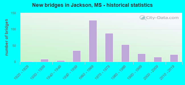
- New bridges - historical statistics
- 11910-1919
- 21920-1929
- 91930-1939
- 41940-1949
- 351950-1959
- 1281960-1969
- 881970-1979
- 531980-1989
- 251990-1999
- 152000-2009
- 232010-2019

- Reconstructed bridges - Historical Statistics
- 11950-1959
- 31960-1969
- 11970-1979
- 11980-1989
- 111990-1999
- 42000-2009
- 02010-2019
- 22020-2022


- Bridge Condition - Deck
- 8.5%Very good
- 27.7%Good
- 25.0%Satisfactory
- 36.2%Fair
- 2.3%Poor
- 0.4%Serious

- Bridge Condition - Superstructure
- 39.6%Very good
- 22.3%Good
- 16.9%Satisfactory
- 18.5%Fair
- 1.9%Poor
- 0.8%Serious

- Bridge Condition - Substructure
- 46.9%Very good
- 29.6%Good
- 6.9%Satisfactory
- 8.8%Fair
- 5.4%Poor
- 0.8%Serious
- 1.5%Critical

- Bridge Condition - Channel
- 0.5%Excellent
- 23.8%Very good
- 37.6%Good
- 18.8%Satisfactory
- 13.9%Fair
- 4.0%Poor
- 1.5%Serious

- Bridge Condition - Culverts
- 23.2%Very good
- 42.9%Good
- 32.1%Satisfactory
- 1.8%Fair
Find on map >> Show street view
Structure Number: SA250000000A264, Location: SEC 34 T 6N R 1E (Lat: 32.326611, Lng: -90.188889), Route carried "on" structure: City street 1605, Year Built: 2016, Status: Open, Structure Length: 0.94m (3.08ft), Average Daily Traffic: 110 (year 2020), Truck Traffic: 80%, Average Future Daily Traffic: 165 (year 2040), Design Load: HL 93, Features Intersected: TRIB TO TOWN CREEK, Facility Carried by Structure: READY MIX STREET
Minimum Vertical Clearance: 30+ m (98+ ft), Kilometerpoint: 0.160, Lanes on structure: 2, Owner: City or Municipal Highway Agency, Approaching Roadway Width: 7.3m (24.0ft), Material/Design: Concrete, Design/Construction: Channel Beam, Number Of Spans In Main Unit: 1, Length of Maximum Span: 9.4m (30.8ft), Curb or Sidewalk Widths: Left: 0.2m (0.7ft), Right: 0.2m (0.7ft), Curb-To-Curb Width: 7.3m (24.0ft), Out-to-Out Width: 7.7m (25.3ft)
Condition: Deck: Very good, Superstructure: Very good, Substructure: Very good, Channel: Good, Operating Rating: 43.7 metric tons, Method Used To Determine Operating Rating: Load and Resistance Factor Rating (LRFR) rating reported by rating factor(RF) method using HL-93 loadings, Inventory Rating: 33.7 metric tons, Method Used To Determine Inventory Rating: Load and Resistance Factor Rating (LRFR) rating reported by rating factor(RF) method using HL-93 loadings, Structural Evaluation: Equal to present desirable criteria, Deck Geometry: Somewhat better than minimum adequacy, Waterway Adequacy: Equal to present desirable criteria, Approach Roadway Alignment: Equal to present desirable criteria, Designated Inspection Frequency: Every 24 months, Inspection Date: May 2021, Deck Structure Type: Concrete Precast Panels, Wearing Surface/Protective System: Wearing Surface: Monolithic Concrete
Find on map >> Show street view
Structure Number: SA250000000A41, Location: SEC 2 T 6N R 1E (Lat: 32.385589, Lng: -90.163711), Route carried "on" structure: City street 82540, Year Built: 2019, Status: Open, Structure Length: 2.10m (6.89ft), Average Daily Traffic: 9,700 (year 2020), Truck Traffic: 8%, Average Future Daily Traffic: 14,550 (year 2040), Design Load: HL 93, Features Intersected: BRANCH HANGING MOSS CK, Facility Carried by Structure: BEASLEY ROAD
Minimum Vertical Clearance: 30+ m (98+ ft), Kilometerpoint: 5.900, Lanes on structure: 2, Owner: City or Municipal Highway Agency, Approaching Roadway Width: 8.1m (26.6ft), Material/Design: Concrete, Design/Construction: Channel Beam, Number Of Spans In Main Unit: 3, Length of Maximum Span: 9.4m (30.8ft), Curb or Sidewalk Widths: Left: 0.5m (1.6ft), Right: 0.5m (1.6ft), Curb-To-Curb Width: 8.5m (27.9ft), Out-to-Out Width: 9.5m (31.2ft)
Condition: Deck: Very good, Superstructure: Very good, Substructure: Very good, Channel: Very good, Operating Rating: 43.7 metric tons, Method Used To Determine Operating Rating: Load and Resistance Factor Rating (LRFR) rating reported by rating factor(RF) method using HL-93 loadings, Inventory Rating: 33.7 metric tons, Method Used To Determine Inventory Rating: Load and Resistance Factor Rating (LRFR) rating reported by rating factor(RF) method using HL-93 loadings, Structural Evaluation: Equal to present desirable criteria, Deck Geometry: High priority of replacement, Waterway Adequacy: Equal to present desirable criteria, Approach Roadway Alignment: Equal to present desirable criteria, Designated Inspection Frequency: Every 24 months, Inspection Date: June 2020, Deck Structure Type: Concrete Precast Panels, Wearing Surface/Protective System: Wearing Surface: Monolithic Concrete
Find on map >> Show street view
Structure Number: 11000200250449A, Location: 3.7 MI E SR 18 (Lat: 32.276592, Lng: -90.208889), Route carried "under" structure: Ramp Interstate 20, Year Built: 1966, Structure Length: 0. m, Average Daily Traffic: 14,000 (year 2017), Truck Traffic: 13%, Features Intersected: I 55 TO TERRY ROAD
Minimum Vertical Clearance: 4.67m (15.32ft), Kilometerpoint: 0.257, Lanes on structure: 4, Lanes under structure: 1, Material/Design: Concrete continuous, Design/Construction: Box Beam or Girders - Single/Spread, Length of Maximum Span: 35.1m (115.2ft)
Find on map >> Show street view
Structure Number: 11000200250456, Location: 0.4 MI E I 55S/I 20W (Lat: 32.276589, Lng: -90.198219), Route carried "under" structure: US 51, Year Built: 2011, Structure Length: 0. m, Average Daily Traffic: 3,100 (year 2019), Truck Traffic: 8%, Features Intersected: US 51, Facility Carried by Structure: I 20 WB LANE
Minimum Vertical Clearance: 5.18m (16.99ft), Kilometerpoint: 1.603, Lanes on structure: 4, Lanes under structure: 3, Material/Design: Steel continuous, Design/Construction: Stringer/Multi-beam, Length of Maximum Span: 44.2m (145.0ft)
Find on map >> Show street view
Structure Number: 11000200250456, Location: 0.4 MI E I 55S/I 20W (Lat: 32.276619, Lng: -90.198511), Route carried "under" structure: US 51, Year Built: 2011, Structure Length: 0. m, Average Daily Traffic: 3,100 (year 2019), Truck Traffic: 8%, Features Intersected: US 51, Facility Carried by Structure: I 20 WB LANE
Minimum Vertical Clearance: 4.96m (16.27ft), Kilometerpoint: 1.862, Lanes on structure: 2, Lanes under structure: 2, Material/Design: Steel continuous, Design/Construction: Stringer/Multi-beam, Length of Maximum Span: 44.2m (145.0ft)
Find on map >> Show street view
Structure Number: 11000550250969, Location: I 55S OVER I 55N TO WW DR (Lat: 32.325781, Lng: -90.161169), Route carried "under" structure: Ramp Interstate 55, Year Built: 1966, Structure Length: 0. m, Average Daily Traffic: 8,700 (year 2017), Truck Traffic: 8%, Features Intersected: I 55 RAMP TO WW DRIVE
Minimum Vertical Clearance: 4.64m (15.22ft), Kilometerpoint: 0.269, Lanes on structure: 1, Lanes under structure: 1, Material/Design: Concrete continuous, Design/Construction: Box Beam or Girders - Single/Spread, Length of Maximum Span: 27.4m (89.9ft)
Find on map >> Show street view
Structure Number: 11000550610931, Location: JCT I 55 & I 20 (Lat: 32.276211, Lng: -90.175850), Route carried "under" structure: Interstate 20, Year Built: 1966, Structure Length: 0. m, Average Daily Traffic: 13,000 (year 2017), Truck Traffic: 8%, Features Intersected: OVER I 20 WB
Minimum Vertical Clearance: 5.18m (16.99ft), Kilometerpoint: 43.525, Lanes on structure: 2, Lanes under structure: 2, Material/Design: Concrete continuous, Design/Construction: Box Beam or Girders - Single/Spread, Length of Maximum Span: 33.5m (109.9ft)
Find on map >> Show street view
Structure Number: 11000550610934A, Location: I 55 OVER US 80 (Lat: 32.280619, Lng: -90.173150), Route carried "under" structure: US 80, Year Built: 1967, Structure Length: 0. m, Average Daily Traffic: 25,000 (year 2017), Truck Traffic: 8%, Features Intersected: US 80/KCS RR, Facility Carried by Structure: I 55
Minimum Vertical Clearance: 5.00m (16.40ft), Kilometerpoint: 0.428, Lanes on structure: 4, Lanes under structure: 4, Material/Design: Prestressed concrete, Design/Construction: Stringer/Multi-beam, Length of Maximum Span: 21.3m (69.9ft)
Find on map >> Show street view
Structure Number: 11000550610934B, Location: I 55 OVER US 80 (Lat: 32.280519, Lng: -90.172611), Route carried "under" structure: US 80, Year Built: 1967, Structure Length: 0. m, Average Daily Traffic: 13,000 (year 2017), Truck Traffic: 8%, Features Intersected: US 80/KCS RR, Facility Carried by Structure: I 55
Minimum Vertical Clearance: 5.05m (16.57ft), Kilometerpoint: 0.481, Lanes on structure: 2, Lanes under structure: 4, Material/Design: Prestressed concrete, Design/Construction: Stringer/Multi-beam, Length of Maximum Span: 21.3m (69.9ft)
Find on map >> Show street view
Structure Number: 11002200250001A, Location: I20E TO I 220N OVER I 20W (Lat: 32.289853, Lng: -90.252000), Route carried "under" structure: Interstate 20, Year Built: 1969, Structure Length: 0. m, Average Daily Traffic: 35,500 (year 2017), Truck Traffic: 8%, Features Intersected: I 20 WEST
Minimum Vertical Clearance: 4.73m (15.52ft), Kilometerpoint: 0.278, Lanes on structure: 2, Lanes under structure: 2, Material/Design: Steel continuous, Design/Construction: Stringer/Multi-beam, Length of Maximum Span: 54.9m (180.1ft)
Find on map >> Show street view
Structure Number: 11002200250001B, Location: I220S TO I 20E OVER I 20W (Lat: 32.289850, Lng: -90.247900), Route carried "under" structure: Interstate 20, Year Built: 1969, Structure Length: 0. m, Average Daily Traffic: 37,000 (year 2017), Truck Traffic: 8%, Features Intersected: I 20 WEST
Minimum Vertical Clearance: 5.19m (17.03ft), Kilometerpoint: 4.645, Lanes on structure: 2, Lanes under structure: 2, Material/Design: Steel continuous, Design/Construction: Stringer/Multi-beam, Length of Maximum Span: 51.8m (169.9ft)
Find on map >> Show street view
Structure Number: 11002200250002, Location: 0.2 MI N I 20 (Lat: 32.292236, Lng: -90.249472), Route carried "under" structure: Ramp Interstate 220, Year Built: 1969, Structure Length: 0. m, Average Daily Traffic: 11,000 (year 2017), Truck Traffic: 8%, Features Intersected: I 220 NORTH
Minimum Vertical Clearance: 4.97m (16.31ft), Kilometerpoint: 0.193, Lanes on structure: 2, Lanes under structure: 1, Material/Design: Steel continuous, Design/Construction: Stringer/Multi-beam, Length of Maximum Span: 36.6m (120.1ft)
Find on map >> Show street view
Structure Number: 11002200250008A, Location: 0.8 MI N I 20 (Lat: 32.300469, Lng: -90.246650), Route carried "under" structure: US 80, Year Built: 1978, Structure Length: 0. m, Average Daily Traffic: 12,000 (year 2017), Truck Traffic: 8%, Features Intersected: US 80, Facility Carried by Structure: I 220
Minimum Vertical Clearance: 4.95m (16.24ft), Kilometerpoint: 9.928, Lanes on structure: 3, Lanes under structure: 6, Material/Design: Concrete continuous, Design/Construction: Box Beam or Girders - Single/Spread, Length of Maximum Span: 39.6m (129.9ft)
Find on map >> Show street view
Structure Number: 11002200250008A, Location: 0.8 MI N I 20 (Lat: 32.300581, Lng: -90.246600), Route carried "under" structure: US 80, Year Built: 1978, Structure Length: 0. m, Average Daily Traffic: 12,000 (year 2017), Truck Traffic: 8%, Features Intersected: US 80, Facility Carried by Structure: I 220
Minimum Vertical Clearance: 4.95m (16.24ft), Kilometerpoint: 1.452, Lanes on structure: 3, Lanes under structure: 6, Material/Design: Concrete continuous, Design/Construction: Box Beam or Girders - Single/Spread, Length of Maximum Span: 39.6m (129.9ft)
Find on map >> Show street view
Structure Number: 11002200250008B, Location: 0.8 MI N I 20 (Lat: 32.300461, Lng: -90.246350), Route carried "under" structure: US 80, Year Built: 1978, Structure Length: 0. m, Average Daily Traffic: 10,000 (year 2017), Truck Traffic: 8%, Features Intersected: US 80, Facility Carried by Structure: I 220
Minimum Vertical Clearance: 5.41m (17.75ft), Kilometerpoint: 1.424, Lanes on structure: 3, Lanes under structure: 6, Material/Design: Concrete continuous, Design/Construction: Box Beam or Girders - Single/Spread, Length of Maximum Span: 39.6m (129.9ft)
Find on map >> Show street view
Structure Number: 11002200250008B, Location: 0.8 MI N I 20 (Lat: 32.300350, Lng: -90.246400), Route carried "under" structure: US 80, Year Built: 1978, Structure Length: 0. m, Average Daily Traffic: 10,000 (year 2017), Truck Traffic: 8%, Features Intersected: US 80, Facility Carried by Structure: I 220
Minimum Vertical Clearance: 5.44m (17.85ft), Kilometerpoint: 9.955, Lanes on structure: 3, Lanes under structure: 6, Material/Design: Concrete continuous, Design/Construction: Box Beam or Girders - Single/Spread, Length of Maximum Span: 39.6m (129.9ft)
Find on map >> Show street view
Structure Number: 11002200250051A, Location: I 220 OVER US 49 (Lat: 32.359481, Lng: -90.235939), Route carried "under" structure: US 49, Year Built: 1976, Structure Length: 0. m, Average Daily Traffic: 11,000 (year 2017), Truck Traffic: 8%, Features Intersected: US 49, Facility Carried by Structure: I 220
Minimum Vertical Clearance: 4.93m (16.17ft), Kilometerpoint: 16.388, Lanes on structure: 3, Lanes under structure: 6, Material/Design: Steel continuous, Design/Construction: Stringer/Multi-beam, Length of Maximum Span: 42.7m (140.1ft)
Find on map >> Show street view
Structure Number: 11002200250051A, Location: I 220 OVER US 49 (Lat: 32.359581, Lng: -90.235789), Route carried "under" structure: US 49, Year Built: 1976, Structure Length: 0. m, Average Daily Traffic: 11,000 (year 2017), Truck Traffic: 8%, Features Intersected: US 49, Facility Carried by Structure: I 220
Minimum Vertical Clearance: 5.09m (16.70ft), Kilometerpoint: 0.072, Lanes on structure: 3, Lanes under structure: 6, Material/Design: Steel continuous, Design/Construction: Stringer/Multi-beam, Length of Maximum Span: 42.7m (140.1ft)
Find on map >> Show street view
Structure Number: 11002200250051B, Location: I 220 OVER US 49 (Lat: 32.359400, Lng: -90.235600), Route carried "under" structure: US 49, Year Built: 1976, Structure Length: 0. m, Average Daily Traffic: 11,000 (year 2017), Truck Traffic: 8%, Features Intersected: US 49, Facility Carried by Structure: I 220
Minimum Vertical Clearance: 4.95m (16.24ft), Kilometerpoint: 0.045, Lanes on structure: 3, Lanes under structure: 6, Material/Design: Steel continuous, Design/Construction: Stringer/Multi-beam, Length of Maximum Span: 42.7m (140.1ft)
Find on map >> Show street view
Structure Number: 11002200250051B, Location: I 220 OVER US 49 (Lat: 32.359300, Lng: -90.235750), Route carried "under" structure: US 49, Year Built: 1976, Structure Length: 0. m, Average Daily Traffic: 11,000 (year 2017), Truck Traffic: 8%, Features Intersected: US 49, Facility Carried by Structure: I 220
Minimum Vertical Clearance: 4.80m (15.75ft), Kilometerpoint: 16.414, Lanes on structure: 3, Lanes under structure: 6, Material/Design: Steel continuous, Design/Construction: Stringer/Multi-beam, Length of Maximum Span: 42.7m (140.1ft)
Find on map >> Show street view
Structure Number: 17000200250448, Location: 3.6 MI E SR 18 (Lat: 32.277261, Lng: -90.211550), Route carried "under" structure: Ramp Interstate 20, Year Built: 1966, Structure Length: 0. m, Average Daily Traffic: 5,000 (year 2017), Truck Traffic: 8%, Features Intersected: RAMP I 20E TO I 55S
Minimum Vertical Clearance: 4.90m (16.08ft), Kilometerpoint: 0.727, Lanes on structure: 1, Lanes under structure: 1, Material/Design: Concrete continuous, Design/Construction: Box Beam or Girders - Single/Spread, Length of Maximum Span: 24.4m (80.1ft)
Find on map >> Show street view
Structure Number: 17000550250912, Location: 0.4 MI N MCDOWELL RD (Lat: 32.274300, Lng: -90.209119), Route carried "under" structure: Interstate 55, Year Built: 1966, Structure Length: 0. m, Average Daily Traffic: 19,000 (year 2017), Truck Traffic: 8%, Features Intersected: I20 WB TO I55SB AND US51
Minimum Vertical Clearance: 4.84m (15.88ft), Kilometerpoint: 16.098, Lanes on structure: 1, Lanes under structure: 3, Material/Design: Concrete continuous, Design/Construction: Box Beam or Girders - Single/Spread, Length of Maximum Span: 30.5m (100.1ft)
Find on map >> Show street view
Structure Number: 17000550250912, Location: 0.4 MI N MCDOWELL RD (Lat: 32.274050, Lng: -90.209081), Route carried "under" structure: US 51, Year Built: 1966, Structure Length: 0. m, Average Daily Traffic: 3,500 (year 2017), Truck Traffic: 8%, Features Intersected: I20 WB TO I55SB AND US51, Facility Carried by Structure: I55 NB TO I20WB
Minimum Vertical Clearance: 6.30m (20.67ft), Kilometerpoint: 0.521, Lanes on structure: 1, Lanes under structure: 2, Material/Design: Concrete continuous, Design/Construction: Box Beam or Girders - Single/Spread, Length of Maximum Span: 30.5m (100.1ft)
Find on map >> Show street view
Structure Number: 17000550250949, Location: 1.8 MI N INT I 55 I 20 (Lat: 32.299961, Lng: -90.167739), Route carried "under" structure: Ramp Interstate 55, Year Built: 1967, Structure Length: 0. m, Average Daily Traffic: 6,500 (year 2017), Truck Traffic: 8%, Features Intersected: RAMP B AT HIGH ST
Minimum Vertical Clearance: 4.90m (16.08ft), Kilometerpoint: 0.274, Lanes on structure: 1, Lanes under structure: 1, Material/Design: Concrete continuous, Design/Construction: Box Beam or Girders - Single/Spread, Length of Maximum Span: 26.8m (87.9ft)
Find on map >> Show street view
Structure Number: 1700055025097, Location: I 55N RAMP OVER WW DR (Lat: 32.325781, Lng: -90.161181), Route carried "under" structure: Ramp Interstate 55, Year Built: 1966, Structure Length: 0. m, Average Daily Traffic: 8,600 (year 2017), Truck Traffic: 8%, Features Intersected: WW DR TO I 55N RAMP
Minimum Vertical Clearance: 4.62m (15.16ft), Kilometerpoint: 0.230, Lanes on structure: 1, Lanes under structure: 2, Material/Design: Concrete continuous, Design/Construction: Box Beam or Girders - Single/Spread, Length of Maximum Span: 27.4m (89.9ft)
Find on map >> Show street view
Structure Number: 17002200450114, Location: JCT I 220 AND I 55 (Lat: 32.411161, Lng: -90.147314), Route carried "under" structure: Interstate 55, Year Built: 1979, Structure Length: 0. m, Average Daily Traffic: 50,500 (year 2017), Truck Traffic: 8%, Features Intersected: I 55
Minimum Vertical Clearance: 5.43m (17.81ft), Kilometerpoint: 0.299, Lanes on structure: 1, Lanes under structure: 4, Material/Design: Concrete continuous, Design/Construction: Box Beam or Girders - Single/Spread, Length of Maximum Span: 33.5m (109.9ft)
Find on map >> Show street view
Structure Number: 17002200450114, Location: JCT I 220 AND I 55 (Lat: 32.411161, Lng: -90.147314), Route carried "under" structure: Interstate 55, Year Built: 1979, Structure Length: 0. m, Average Daily Traffic: 50,500 (year 2017), Truck Traffic: 8%, Features Intersected: I 55
Minimum Vertical Clearance: 6.09m (19.98ft), Kilometerpoint: 0.299, Lanes on structure: 1, Lanes under structure: 4, Material/Design: Concrete continuous, Design/Construction: Box Beam or Girders - Single/Spread, Length of Maximum Span: 33.5m (109.9ft)
Find on map >> Show street view
Structure Number: 18000550250986, Location: 1.2 MI N SR 25 (Lat: 32.350189, Lng: -90.153669), Route carried "under" structure: Interstate 55, Year Built: 1989, Structure Length: 0. m, Average Daily Traffic: 58,000 (year 2017), Truck Traffic: 8%, Features Intersected: I 55, Facility Carried by Structure: CANTON FLYOVER
Minimum Vertical Clearance: 5.63m (18.47ft), Kilometerpoint: 5.570, Lanes on structure: 2, Lanes under structure: 11, Material/Design: Concrete continuous, Design/Construction: Box Beam or Girders - Single/Spread, Length of Maximum Span: 42.7m (140.1ft)
Find on map >> Show street view
Structure Number: 18000550250986, Location: 1.2 MI N SR 25 (Lat: 32.350311, Lng: -90.153369), Route carried "under" structure: Interstate 55, Year Built: 1989, Structure Length: 0. m, Average Daily Traffic: 58,000 (year 2017), Truck Traffic: 8%, Features Intersected: I 55, Facility Carried by Structure: CANTON FLYOVER
Minimum Vertical Clearance: 5.19m (17.03ft), Kilometerpoint: 38.508, Lanes on structure: 2, Lanes under structure: 11, Material/Design: Concrete continuous, Design/Construction: Box Beam or Girders - Single/Spread, Length of Maximum Span: 42.7m (140.1ft)
Find on map >> Show street view
Structure Number: 18000550250986, Location: 1.2 MI N SR 25 (Lat: 32.350489, Lng: -90.153031), Route carried "under" structure: Ramp Interstate 55, Year Built: 1989, Structure Length: 0. m, Average Daily Traffic: 10,000 (year 2017), Truck Traffic: 8%, Features Intersected: I 55, Facility Carried by Structure: CANTON FLYOVER
Minimum Vertical Clearance: 5.69m (18.67ft), Kilometerpoint: 0.967, Lanes on structure: 2, Lanes under structure: 11, Material/Design: Concrete continuous, Design/Construction: Box Beam or Girders - Single/Spread, Length of Maximum Span: 42.7m (140.1ft)
Find on map >> Show street view
Structure Number: 18000550251007, Location: 3.7 MI N OF SR 25 (Lat: 32.379989, Lng: -90.147289), Route carried "under" structure: Interstate 55, Year Built: 1987, Structure Length: 0. m, Average Daily Traffic: 45,000 (year 2017), Truck Traffic: 8%, Features Intersected: I 55, Facility Carried by Structure: BRIARWOOD LOOP
Minimum Vertical Clearance: 4.95m (16.24ft), Kilometerpoint: 2.208, Lanes on structure: 1, Lanes under structure: 9, Material/Design: Concrete continuous, Design/Construction: Box Beam or Girders - Single/Spread, Length of Maximum Span: 39.3m (128.9ft)
Find on map >> Show street view
Structure Number: 18000550251007, Location: 3.7 MI N OF SR 25 (Lat: 32.379939, Lng: -90.147089), Route carried "under" structure: Interstate 55, Year Built: 1987, Structure Length: 0. m, Average Daily Traffic: 45,000 (year 2017), Truck Traffic: 8%, Features Intersected: I 55, Facility Carried by Structure: BRIARWOOD LOOP
Minimum Vertical Clearance: 5.15m (16.90ft), Kilometerpoint: 41.849, Lanes on structure: 1, Lanes under structure: 9, Material/Design: Concrete continuous, Design/Construction: Box Beam or Girders - Single/Spread, Length of Maximum Span: 39.3m (128.9ft)
Find on map >> Show street view
Structure Number: 21000490251667, Location: 2.0 MI N I-220 (Lat: 32.381489, Lng: -90.259850), Route carried "under" structure: US 49, Year Built: 2000, Structure Length: 0. m, Average Daily Traffic: 7,000 (year 2017), Truck Traffic: 10%, Features Intersected: US 49, Facility Carried by Structure: NATCHEZ TRACE
Minimum Vertical Clearance: 5.08m (16.67ft), Kilometerpoint: 13.068, Lanes on structure: 2, Lanes under structure: 4, Material/Design: Prestressed concrete continuous, Design/Construction: Box Beam or Girders - Single/Spread, Length of Maximum Span: 16.8m (55.1ft)
Find on map >> Show street view
Structure Number: 21000490251667, Location: 2.0 MI N I-220 (Lat: 32.381611, Lng: -90.259700), Route carried "under" structure: US 49, Year Built: 2000, Structure Length: 0. m, Average Daily Traffic: 7,000 (year 2017), Truck Traffic: 10%, Features Intersected: US 49, Facility Carried by Structure: NATCHEZ TRACE
Minimum Vertical Clearance: 5.11m (16.77ft), Kilometerpoint: 3.392, Lanes on structure: 2, Lanes under structure: 4, Material/Design: Prestressed concrete continuous, Design/Construction: Box Beam or Girders - Single/Spread, Length of Maximum Span: 16.8m (55.1ft)
Find on map >> Show street view
Structure Number: 21000800250456, Location: 0.7 MI W US 51 (Lat: 32.284581, Lng: -90.195900), Route carried "under" structure: US 80, Year Built: 1941, Structure Length: 0. m, Average Daily Traffic: 13,000 (year 2017), Truck Traffic: 8%, Features Intersected: US 80, Facility Carried by Structure: CNIC RR
Minimum Vertical Clearance: 4.37m (14.34ft), Kilometerpoint: 15.099, Lanes under structure: 4, Material/Design: Steel, Design/Construction: Stringer/Multi-beam, Length of Maximum Span: 14.3m (46.9ft)
Find on map >> Show street view
Structure Number: 21000800250463, Location: US 80 OVER US 51 (Lat: 32.282539, Lng: -90.184181), Route carried "under" structure: US 51, Year Built: 1938, Structure Length: 0. m, Average Daily Traffic: 3,200 (year 2017), Truck Traffic: 8%, Features Intersected: US 51, ABANDONDED RR, Facility Carried by Structure: US 80
Minimum Vertical Clearance: 5.91m (19.39ft), Kilometerpoint: 0.241, Lanes on structure: 4, Lanes under structure: 4, Material/Design: Steel, Design/Construction: Stringer/Multi-beam, Length of Maximum Span: 19.8m (65.0ft)
Find on map >> Show street view
Structure Number: 21000800250463, Location: US 80 OVER US 51 (Lat: 32.282519, Lng: -90.184061), Route carried "under" structure: US 51, Year Built: 1938, Structure Length: 0. m, Average Daily Traffic: 3,200 (year 2017), Truck Traffic: 8%, Features Intersected: US 51, ABANDONDED RR, Facility Carried by Structure: US 80
Minimum Vertical Clearance: 6.14m (20.14ft), Kilometerpoint: 3.214, Lanes on structure: 4, Lanes under structure: 4, Material/Design: Steel, Design/Construction: Stringer/Multi-beam, Length of Maximum Span: 19.8m (65.0ft)
Find on map >> Show street view
Structure Number: 31000180250556A, Location: SR 18 OVER I 20 (Lat: 32.293111, Lng: -90.266661), Route carried "under" structure: Interstate 20, Year Built: 1969, Structure Length: 0. m, Average Daily Traffic: 35,500 (year 2017), Truck Traffic: 8%, Features Intersected: I 20, Facility Carried by Structure: SR 18
Minimum Vertical Clearance: 4.80m (15.75ft), Kilometerpoint: 6.474, Lanes on structure: 3, Lanes under structure: 6, Material/Design: Concrete continuous, Design/Construction: Box Beam or Girders - Single/Spread, Length of Maximum Span: 31.1m (102.0ft)
Find on map >> Show street view
Structure Number: 31000180250556A, Location: SR 18 OVER I 20 (Lat: 32.292931, Lng: -90.266861), Route carried "under" structure: Interstate 20, Year Built: 1969, Structure Length: 0. m, Average Daily Traffic: 35,500 (year 2017), Truck Traffic: 8%, Features Intersected: I 20, Facility Carried by Structure: SR 18
Minimum Vertical Clearance: 4.85m (15.91ft), Kilometerpoint: 36.846, Lanes on structure: 3, Lanes under structure: 6, Material/Design: Concrete continuous, Design/Construction: Box Beam or Girders - Single/Spread, Length of Maximum Span: 31.1m (102.0ft)
Find on map >> Show street view
Structure Number: 31000180250556B, Location: SR 18 OVER I 20 (Lat: 32.293011, Lng: -90.266481), Route carried "under" structure: Interstate 20, Year Built: 1969, Structure Length: 0. m, Average Daily Traffic: 35,500 (year 2017), Truck Traffic: 8%, Features Intersected: I 20, Facility Carried by Structure: SR 18
Minimum Vertical Clearance: 5.28m (17.32ft), Kilometerpoint: 6.455, Lanes on structure: 2, Lanes under structure: 6, Material/Design: Concrete continuous, Design/Construction: Box Beam or Girders - Single/Spread, Length of Maximum Span: 31.1m (102.0ft)
Find on map >> Show street view
Structure Number: 31000180250556B, Location: SR 18 OVER I 20 (Lat: 32.292839, Lng: -90.266681), Route carried "under" structure: Interstate 20, Year Built: 1969, Structure Length: 0. m, Average Daily Traffic: 35,500 (year 2017), Truck Traffic: 8%, Features Intersected: I 20, Facility Carried by Structure: SR 18
Minimum Vertical Clearance: 5.22m (17.13ft), Kilometerpoint: 36.865, Lanes on structure: 2, Lanes under structure: 6, Material/Design: Concrete continuous, Design/Construction: Box Beam or Girders - Single/Spread, Length of Maximum Span: 31.1m (102.0ft)
Find on map >> Show street view
Structure Number: 31000250250000A, Location: SR 25 OVER I 55 (Lat: 32.333661, Lng: -90.162989), Route carried "under" structure: Interstate 55, Year Built: 1970, Structure Length: 0. m, Average Daily Traffic: 64,500 (year 2017), Truck Traffic: 8%, Features Intersected: I 55, Facility Carried by Structure: SR 25
Minimum Vertical Clearance: 4.82m (15.81ft), Kilometerpoint: 7.617, Lanes on structure: 8, Lanes under structure: 4, Material/Design: Steel continuous, Design/Construction: Stringer/Multi-beam, Length of Maximum Span: 23.8m (78.1ft)
Find on map >> Show street view
Structure Number: 31000250250000A, Location: SR 25 OVER I 55 (Lat: 32.333661, Lng: -90.162469), Route carried "under" structure: Interstate 55, Year Built: 1970, Structure Length: 0. m, Average Daily Traffic: 64,500 (year 2017), Truck Traffic: 8%, Features Intersected: I 55, Facility Carried by Structure: SR 25
Minimum Vertical Clearance: 4.90m (16.08ft), Kilometerpoint: 36.456, Lanes on structure: 8, Lanes under structure: 4, Material/Design: Steel continuous, Design/Construction: Stringer/Multi-beam, Length of Maximum Span: 23.8m (78.1ft)
Find on map >> Show street view
Structure Number: 51000200250414, Location: 0.3 MI E SR 18 (Lat: 32.291061, Lng: -90.261619), Route carried "under" structure: Interstate 20, Year Built: 1966, Structure Length: 0. m, Average Daily Traffic: 35,500 (year 2017), Truck Traffic: 8%, Features Intersected: I 20, Facility Carried by Structure: ROBINSON ROAD EXT
Minimum Vertical Clearance: 5.08m (16.67ft), Kilometerpoint: 5.943, Lanes on structure: 2, Lanes under structure: 4, Material/Design: Prestressed concrete, Design/Construction: Stringer/Multi-beam, Length of Maximum Span: 21.3m (69.9ft)
Find on map >> Show street view
Structure Number: 51000200250414, Location: 0.3 MI E SR 18 (Lat: 32.290650, Lng: -90.261631), Route carried "under" structure: Interstate 20, Year Built: 1966, Structure Length: 0. m, Average Daily Traffic: 35,500 (year 2017), Truck Traffic: 8%, Features Intersected: I 20, Facility Carried by Structure: ROBINSON ROAD EXT
Minimum Vertical Clearance: 5.07m (16.63ft), Kilometerpoint: 37.403, Lanes on structure: 2, Lanes under structure: 4, Material/Design: Prestressed concrete, Design/Construction: Stringer/Multi-beam, Length of Maximum Span: 21.3m (69.9ft)
Find on map >> Show street view
Structure Number: 51000550250873, Location: ELTON RD INTERSECTION (Lat: 32.221331, Lng: -90.226119), Route carried "under" structure: Interstate 55, Year Built: 1959, Structure Length: 0. m, Average Daily Traffic: 24,500 (year 2017), Truck Traffic: 8%, Features Intersected: I 55, Facility Carried by Structure: ELTON ROAD
Minimum Vertical Clearance: 5.32m (17.45ft), Kilometerpoint: 22.299, Lanes on structure: 2, Lanes under structure: 6, Material/Design: Concrete continuous, Design/Construction: Box Beam or Girders - Single/Spread, Length of Maximum Span: 20.4m (66.9ft)
Find on map >> Show street view
Structure Number: 51000550250873, Location: ELTON RD INTERSECTION (Lat: 32.221300, Lng: -90.225981), Route carried "under" structure: Interstate 55, Year Built: 1959, Structure Length: 0. m, Average Daily Traffic: 24,500 (year 2017), Truck Traffic: 8%, Features Intersected: I 55, Facility Carried by Structure: ELTON ROAD
Minimum Vertical Clearance: 4.98m (16.34ft), Kilometerpoint: 21.971, Lanes on structure: 2, Lanes under structure: 6, Material/Design: Concrete continuous, Design/Construction: Box Beam or Girders - Single/Spread, Length of Maximum Span: 20.4m (66.9ft)
Find on map >> Show street view
Structure Number: 51000550250889, Location: 2.4 MI S I55S/I20W (Lat: 32.242231, Lng: -90.215181), Route carried "under" structure: Interstate 55, Year Built: 1959, Structure Length: 0. m, Average Daily Traffic: 24,500 (year 2017), Truck Traffic: 8%, Features Intersected: I 55, Facility Carried by Structure: SAVANNA STREET
Minimum Vertical Clearance: 5.69m (18.67ft), Kilometerpoint: 19.763, Lanes on structure: 2, Lanes under structure: 6, Material/Design: Concrete continuous, Design/Construction: Box Beam or Girders - Single/Spread, Length of Maximum Span: 21.3m (69.9ft)
Find on map >> Show street view
Structure Number: 51000550250889, Location: 2.4 MI S I55S/I20W (Lat: 32.242250, Lng: -90.215031), Route carried "under" structure: Interstate 55, Year Built: 1959, Structure Length: 0. m, Average Daily Traffic: 24,500 (year 2017), Truck Traffic: 8%, Features Intersected: I 55, Facility Carried by Structure: SAVANNA STREET
Minimum Vertical Clearance: 4.92m (16.14ft), Kilometerpoint: 24.515, Lanes on structure: 2, Lanes under structure: 6, Material/Design: Concrete continuous, Design/Construction: Box Beam or Girders - Single/Spread, Length of Maximum Span: 21.3m (69.9ft)
Find on map >> Show street view
Structure Number: 51000550250897, Location: 1.6 MI S I55S/I20W (Lat: 32.252361, Lng: -90.211939), Route carried "under" structure: Interstate 55, Year Built: 1962, Structure Length: 0. m, Average Daily Traffic: 24,500 (year 2017), Truck Traffic: 8%, Features Intersected: I 55, Facility Carried by Structure: DANIEL LAKE ROAD
Minimum Vertical Clearance: 4.98m (16.34ft), Kilometerpoint: 18.594, Lanes on structure: 1, Lanes under structure: 6, Material/Design: Concrete continuous, Design/Construction: Box Beam or Girders - Single/Spread, Length of Maximum Span: 21.3m (69.9ft)
Find on map >> Show street view
Structure Number: 51000550250897, Location: 1.6 MI S I55S/I20W (Lat: 32.252400, Lng: -90.211781), Route carried "under" structure: Interstate 55, Year Built: 1962, Structure Length: 0. m, Average Daily Traffic: 24,500 (year 2017), Truck Traffic: 8%, Features Intersected: I 55, Facility Carried by Structure: DANIEL LAKE ROAD
Minimum Vertical Clearance: 4.90m (16.08ft), Kilometerpoint: 25.685, Lanes on structure: 1, Lanes under structure: 6, Material/Design: Concrete continuous, Design/Construction: Box Beam or Girders - Single/Spread, Length of Maximum Span: 21.3m (69.9ft)
Find on map >> Show street view
Structure Number: 51000550250957A, Location: 2.6 MI N I 20 (Lat: 32.310100, Lng: -90.163569), Route carried "under" structure: Interstate 55, Year Built: 1967, Structure Length: 0. m, Average Daily Traffic: 66,500 (year 2017), Truck Traffic: 8%, Features Intersected: I 55, Facility Carried by Structure: FORTIFICATION ST
Minimum Vertical Clearance: 5.02m (16.47ft), Kilometerpoint: 10.509, Lanes on structure: 2, Lanes under structure: 7, Material/Design: Concrete continuous, Design/Construction: Box Beam or Girders - Single/Spread, Length of Maximum Span: 27.7m (90.9ft)
Find on map >> Show street view
Structure Number: 51000550250957A, Location: 2.6 MI N I 20 (Lat: 32.309961, Lng: -90.163289), Route carried "under" structure: Interstate 55, Year Built: 1967, Structure Length: 0. m, Average Daily Traffic: 66,500 (year 2017), Truck Traffic: 8%, Features Intersected: I 55, Facility Carried by Structure: FORTIFICATION ST
Minimum Vertical Clearance: 5.46m (17.91ft), Kilometerpoint: 33.592, Lanes on structure: 2, Lanes under structure: 7, Material/Design: Concrete continuous, Design/Construction: Box Beam or Girders - Single/Spread, Length of Maximum Span: 27.7m (90.9ft)
Find on map >> Show street view
Structure Number: 51000550250957B, Location: 2.6 MI N I 20 (Lat: 32.309989, Lng: -90.163639), Route carried "under" structure: Interstate 55, Year Built: 1967, Structure Length: 0. m, Average Daily Traffic: 66,500 (year 2017), Truck Traffic: 8%, Features Intersected: I 55, Facility Carried by Structure: FORTIFICATION ST
Minimum Vertical Clearance: 5.04m (16.54ft), Kilometerpoint: 10.524, Lanes on structure: 2, Lanes under structure: 7, Material/Design: Concrete continuous, Design/Construction: Box Beam or Girders - Single/Spread, Length of Maximum Span: 27.7m (90.9ft)
Find on map >> Show street view
Structure Number: 51000550250957B, Location: 2.6 MI N I 20 (Lat: 32.309850, Lng: -90.163361), Route carried "under" structure: Interstate 55, Year Built: 1967, Structure Length: 0. m, Average Daily Traffic: 66,500 (year 2017), Truck Traffic: 8%, Features Intersected: I 55, Facility Carried by Structure: FORTIFICATION ST
Minimum Vertical Clearance: 5.47m (17.95ft), Kilometerpoint: 33.577, Lanes on structure: 2, Lanes under structure: 7, Material/Design: Concrete continuous, Design/Construction: Box Beam or Girders - Single/Spread, Length of Maximum Span: 27.7m (90.9ft)
Find on map >> Show street view
Structure Number: 51000550250967A, Location: 0.6 MI S SR 25 (Lat: 32.323450, Lng: -90.159050), Route carried "under" structure: Interstate 55, Year Built: 1966, Structure Length: 0. m, Average Daily Traffic: 62,500 (year 2017), Truck Traffic: 8%, Features Intersected: I 55, Facility Carried by Structure: RIVERSIDE DRIVE
Minimum Vertical Clearance: 5.07m (16.63ft), Kilometerpoint: 8.847, Lanes on structure: 2, Lanes under structure: 7, Material/Design: Steel continuous, Design/Construction: Stringer/Multi-beam, Length of Maximum Span: 26.5m (86.9ft)
Find on map >> Show street view
Structure Number: 51000550250967A, Location: 0.6 MI S SR 25 (Lat: 32.323531, Lng: -90.158819), Route carried "under" structure: Interstate 55, Year Built: 1966, Structure Length: 0. m, Average Daily Traffic: 62,500 (year 2017), Truck Traffic: 8%, Features Intersected: I 55, Facility Carried by Structure: RIVERSIDE DRIVE
Minimum Vertical Clearance: 5.17m (16.96ft), Kilometerpoint: 35.277, Lanes on structure: 2, Lanes under structure: 7, Material/Design: Steel continuous, Design/Construction: Stringer/Multi-beam, Length of Maximum Span: 26.5m (86.9ft)
Find on map >> Show street view
Structure Number: 51000550250967B, Location: 0.6 MI S SR 25 (Lat: 32.323331, Lng: -90.158981), Route carried "under" structure: Interstate 55, Year Built: 1966, Structure Length: 0. m, Average Daily Traffic: 64,500 (year 2017), Truck Traffic: 8%, Features Intersected: I 55, Facility Carried by Structure: RIVERSIDE DRIVE
Minimum Vertical Clearance: 5.15m (16.90ft), Kilometerpoint: 8.863, Lanes on structure: 2, Lanes under structure: 7, Material/Design: Steel continuous, Design/Construction: Stringer/Multi-beam, Length of Maximum Span: 26.5m (86.9ft)
Find on map >> Show street view
Structure Number: 51000550250967B, Location: 0.6 MI S SR 25 (Lat: 32.323400, Lng: -90.158761), Route carried "under" structure: Interstate 55, Year Built: 1966, Structure Length: 0. m, Average Daily Traffic: 64,500 (year 2017), Truck Traffic: 8%, Features Intersected: I 55, Facility Carried by Structure: RIVERSIDE DRIVE
Minimum Vertical Clearance: 4.92m (16.14ft), Kilometerpoint: 35.261, Lanes on structure: 2, Lanes under structure: 7, Material/Design: Steel continuous, Design/Construction: Stringer/Multi-beam, Length of Maximum Span: 26.5m (86.9ft)
Find on map >> Show street view
Structure Number: 51000550250985, Location: 1.1 MI N SR 25 (Lat: 32.348319, Lng: -90.154611), Route carried "under" structure: Interstate 55, Year Built: 1989, Structure Length: 0. m, Average Daily Traffic: 58,000 (year 2017), Truck Traffic: 8%, Features Intersected: I 55, Facility Carried by Structure: MEADOWBROOK ROAD
Minimum Vertical Clearance: 5.89m (19.32ft), Kilometerpoint: 5.797, Lanes on structure: 7, Lanes under structure: 8, Material/Design: Prestressed concrete, Design/Construction: Stringer/Multi-beam, Length of Maximum Span: 34.1m (111.9ft)
Find on map >> Show street view
Structure Number: 51000550250985, Location: 1.1 MI N SR 25 (Lat: 32.348281, Lng: -90.154400), Route carried "under" structure: Interstate 55, Year Built: 1989, Structure Length: 0. m, Average Daily Traffic: 58,000 (year 2017), Truck Traffic: 8%, Features Intersected: I 55, Facility Carried by Structure: MEADOWBROOK ROAD
Minimum Vertical Clearance: 5.02m (16.47ft), Kilometerpoint: 38.264, Lanes on structure: 7, Lanes under structure: 8, Material/Design: Prestressed concrete, Design/Construction: Stringer/Multi-beam, Length of Maximum Span: 34.1m (111.9ft)
Find on map >> Show street view
Structure Number: 51000550251008, Location: 3.7 MI N SR 25 (Lat: 32.380339, Lng: -90.147219), Route carried "under" structure: Interstate 55, Year Built: 1982, Structure Length: 0. m, Average Daily Traffic: 44,500 (year 2017), Truck Traffic: 8%, Features Intersected: I 55, Facility Carried by Structure: BRIARWOOD DRIVE
Minimum Vertical Clearance: 5.21m (17.09ft), Kilometerpoint: 2.168, Lanes on structure: 6, Lanes under structure: 9, Material/Design: Prestressed concrete continuous, Design/Construction: Stringer/Multi-beam, Length of Maximum Span: 33.5m (109.9ft)
Find on map >> Show street view
Structure Number: 51000550251008, Location: 3.7 MI N SR 25 (Lat: 32.380339, Lng: -90.147011), Route carried "under" structure: Interstate 55, Year Built: 1982, Structure Length: 0. m, Average Daily Traffic: 44,500 (year 2017), Truck Traffic: 8%, Features Intersected: I 55, Facility Carried by Structure: BRIARWOOD DRIVE
Minimum Vertical Clearance: 5.17m (16.96ft), Kilometerpoint: 41.894, Lanes on structure: 6, Lanes under structure: 9, Material/Design: Prestressed concrete continuous, Design/Construction: Stringer/Multi-beam, Length of Maximum Span: 33.5m (109.9ft)
Find on map >> Show street view
Structure Number: 51002200250017, Location: 0.9 MI N US 80 (Lat: 32.312911, Lng: -90.246739), Route carried "under" structure: Interstate 220, Year Built: 1978, Structure Length: 0. m, Average Daily Traffic: 25,000 (year 2017), Truck Traffic: 8%, Features Intersected: I 220, Facility Carried by Structure: ST. CHARLES STREET
Minimum Vertical Clearance: 4.84m (15.88ft), Kilometerpoint: 12.772, Lanes on structure: 2, Lanes under structure: 4, Material/Design: Prestressed concrete continuous, Design/Construction: Stringer/Multi-beam, Length of Maximum Span: 27.4m (89.9ft)
Find on map >> Show street view
Structure Number: 51002200250017, Location: 0.9 MI N US 80 (Lat: 32.312911, Lng: -90.246450), Route carried "under" structure: Interstate 220, Year Built: 1978, Structure Length: 0. m, Average Daily Traffic: 25,000 (year 2017), Truck Traffic: 8%, Features Intersected: I 220, Facility Carried by Structure: ST. CHARLES STREET
Minimum Vertical Clearance: 5.51m (18.08ft), Kilometerpoint: 2.103, Lanes on structure: 2, Lanes under structure: 4, Material/Design: Prestressed concrete continuous, Design/Construction: Stringer/Multi-beam, Length of Maximum Span: 27.4m (89.9ft)
Find on map >> Show street view
Structure Number: 51002200250022, Location: 2.2 MI N I 20 (Lat: 32.319750, Lng: -90.247831), Route carried "under" structure: Interstate 220, Year Built: 1978, Structure Length: 0. m, Average Daily Traffic: 29,500 (year 2017), Truck Traffic: 8%, Features Intersected: I 220, Facility Carried by Structure: SOUTH DRIVE
Minimum Vertical Clearance: 4.91m (16.11ft), Kilometerpoint: 12.006, Lanes on structure: 4, Lanes under structure: 4, Material/Design: Prestressed concrete continuous, Design/Construction: Stringer/Multi-beam, Length of Maximum Span: 27.4m (89.9ft)
Find on map >> Show street view
Structure Number: 51002200250022, Location: 2.2 MI N I 20 (Lat: 32.319739, Lng: -90.247539), Route carried "under" structure: Interstate 220, Year Built: 1978, Structure Length: 0. m, Average Daily Traffic: 29,500 (year 2017), Truck Traffic: 8%, Features Intersected: I 220, Facility Carried by Structure: SOUTH DRIVE
Minimum Vertical Clearance: 4.98m (16.34ft), Kilometerpoint: 2.868, Lanes on structure: 4, Lanes under structure: 4, Material/Design: Prestressed concrete continuous, Design/Construction: Stringer/Multi-beam, Length of Maximum Span: 27.4m (89.9ft)
Find on map >> Show street view
Structure Number: 51002200250093, Location: 4.2 MI N US 49 (Lat: 32.397731, Lng: -90.180689), Route carried "under" structure: Interstate 220, Year Built: 1978, Structure Length: 0. m, Average Daily Traffic: 25,500 (year 2017), Truck Traffic: 8%, Features Intersected: I 220, Facility Carried by Structure: HANGING MOSS ROAD
Minimum Vertical Clearance: 4.91m (16.11ft), Kilometerpoint: 0.486, Lanes on structure: 4, Lanes under structure: 4, Material/Design: Steel continuous, Design/Construction: Stringer/Multi-beam, Length of Maximum Span: 44.2m (145.0ft)
Find on map >> Show street view
Structure Number: 51002200250093, Location: 4.2 MI N US 49 (Lat: 32.397519, Lng: -90.180531), Route carried "under" structure: Interstate 220, Year Built: 1978, Structure Length: 0. m, Average Daily Traffic: 25,500 (year 2017), Truck Traffic: 8%, Features Intersected: I 220, Facility Carried by Structure: HANGING MOSS ROAD
Minimum Vertical Clearance: 4.92m (16.14ft), Kilometerpoint: 14.359, Lanes on structure: 4, Lanes under structure: 4, Material/Design: Steel continuous, Design/Construction: Stringer/Multi-beam, Length of Maximum Span: 44.2m (145.0ft)