Bridge Statistics for Jenkintown, Pennsylvania (PA)
Condition, Traffic, Stress, Structural Evaluation, Project Costs
- National Bridge Inventory (NBI) Statistics
- 214Number of bridges
- 2,297ft / 700mTotal length
- $92,010,000Total costs
- 1,219,812Total average daily traffic
- 149,700Total average daily truck traffic
- 1,402,844Total future (year 2013) average daily traffic
- National Bridge Inventory (NBI) Registered Bridges for Jenkintown
- No street view available for this location
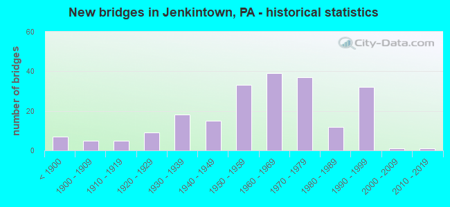
- New bridges - historical statistics
- 7Before 1900
- 51900-1909
- 51910-1919
- 91920-1929
- 181930-1939
- 151940-1949
- 331950-1959
- 391960-1969
- 371970-1979
- 121980-1989
- 321990-1999
- 12000-2009
- 12010-2019

- Reconstructed bridges - Historical Statistics
- 21920-1929
- 01930-1939
- 11940-1949
- 21950-1959
- 51960-1969
- 51970-1979
- 61980-1989
- 131990-1999
- 262000-2009
- 212010-2019
- 22020-2022


- Bridge Condition - Deck
- 10.3%Excellent
- 35.3%Very good
- 25.0%Good
- 22.8%Satisfactory
- 5.4%Fair
- 1.1%Poor
- 0.5%Serious

- Bridge Condition - Superstructure
- 13.5%Very good
- 26.0%Good
- 25.0%Satisfactory
- 28.6%Fair
- 4.7%Poor
- 2.1%Serious

- Bridge Condition - Substructure
- 0.5%Excellent
- 2.1%Very good
- 30.2%Good
- 30.2%Satisfactory
- 29.2%Fair
- 7.8%Poor

- Bridge Condition - Channel
- 3.6%Very good
- 17.0%Good
- 29.1%Satisfactory
- 32.7%Fair
- 17.6%Poor

- Bridge Condition - Culverts
- 45.5%Good
- 27.3%Satisfactory
- 18.2%Fair
- 9.1%Poor
Find on map >> Show street view
Structure Number: 29151, Location: 3 MI N OF TURBOTVILLE (Lat: 41.129250, Lng: -76.762539), Route carried "on" structure: State highway , Year Built: 1957, Status: Open, Structure Length: 0.76m (2.49ft), Average Daily Traffic: 138 (year 2022), Truck Traffic: 6%, Average Future Daily Traffic: 371 (year 2032), Features Intersected: WARIOR RUN CREEK, Facility Carried by Structure: SR 1010
Minimum Vertical Clearance: 30+ m (98+ ft), Kilometerpoint: 0.444, Lanes on structure: 2, Owner: State Highway Agency, Approaching Roadway Width: 6.1m (20.0ft), Skew: 3 degrees, Material/Design: Concrete, Design/Construction: Tee Beam, Number Of Spans In Main Unit: 1, Length of Maximum Span: 6.4m (21.0ft), Curb or Sidewalk Widths: Left: 0.2m (0.7ft), Right: 0.2m (0.7ft), Curb-To-Curb Width: 7.7m (25.3ft), Out-to-Out Width: 8.0m (26.2ft)
Condition: Deck: Good, Superstructure: Good, Substructure: Good, Channel: Fair, Operating Rating: 55.3 metric tons, Method Used To Determine Operating Rating: Load Factor (LF), Inventory Rating: 32.7 metric tons, Method Used To Determine Inventory Rating: Load Factor (LF), Structural Evaluation: Better than present minimum criteria, Deck Geometry: Somewhat better than minimum adequacy, Waterway Adequacy: Better than present minimum criteria, Approach Roadway Alignment: Equal to present desirable criteria, Length Of Structure Improvement: 0.80m (2.62ft), Designated Inspection Frequency: Every 24 months, Inspection Date: December 2019, Deck Structure Type: Concrete Cast-file-Place, Wearing Surface/Protective System: Wearing Surface: Bituminous, Membrane: Preformed Fabric
Find on map >> Show street view
Structure Number: 29155, Location: 1 MI N OF TURBOTVILLE (Lat: 41.116275, Lng: -76.770739), Route carried "on" structure: State highway , Year Built: 1921, Year Reconstructed: 2017, Status: Open, Structure Length: 0.94m (3.08ft), Average Daily Traffic: 374 (year 2020), Truck Traffic: 8%, Average Future Daily Traffic: 592 (year 2032), Design Load: HS 25 or greater, Features Intersected: WARRIOR RUN, Facility Carried by Structure: SR 1011
Minimum Vertical Clearance: 30+ m (98+ ft), Kilometerpoint: 1.202, Lanes on structure: 2, Owner: State Highway Agency, Approaching Roadway Width: 5.5m (18.0ft), Material/Design: Concrete, Design/Construction: Channel Beam, Number Of Spans In Main Unit: 1, Length of Maximum Span: 9.1m (29.9ft), Curb or Sidewalk Widths: Left: 0.2m (0.7ft), Right: 0.2m (0.7ft), Curb-To-Curb Width: 7.1m (23.3ft), Out-to-Out Width: 8.5m (27.9ft)
Condition: Deck: Very good, Superstructure: Very good, Substructure: Satisfactory, Channel: Satisfactory, Inventory Rating: 81.6 metric tons, Method Used To Determine Inventory Rating: Assigned rating based on Load Factor Design (LFD) reported in metric tons, Structural Evaluation: Equal to present minimum criteria, Deck Geometry: Meets minimum limits, Waterway Adequacy: Better than present minimum criteria, Approach Roadway Alignment: Equal to present desirable criteria, Length Of Structure Improvement: 0.90m (2.95ft), Designated Inspection Frequency: Every 24 months, Inspection Date: December 2019, Bridge Improvement Cost: $15,000, Roadway Improvement Cost: $50,000, Total Project Cost: $198,000, Deck Structure Type: Concrete Cast-file-Place, Wearing Surface/Protective System: Wearing Surface: Epoxy Overlay, Deck Protection: Epoxy Coated Reinforcing
Find on map >> Show street view
Structure Number: 29156, Location: 2.0 MI N OF TURBOTVILLE (Lat: 41.122942, Lng: -76.772456), Route carried "on" structure: State highway , Year Built: 1949, Status: Open, Structure Length: 0.64m (2.10ft), Average Daily Traffic: 374 (year 2020), Truck Traffic: 8%, Average Future Daily Traffic: 592 (year 2032), Design Load: HS 20, Features Intersected: OVER WARRIOR RUN, Facility Carried by Structure: SR 1011
Minimum Vertical Clearance: 30+ m (98+ ft), Kilometerpoint: 1.811, Lanes on structure: 2, Owner: State Highway Agency, Approaching Roadway Width: 6.1m (20.0ft), Material/Design: Concrete, Design/Construction: Slab, Number Of Spans In Main Unit: 1, Length of Maximum Span: 5.5m (18.0ft), Curb or Sidewalk Widths: Left: 0.2m (0.7ft), Right: 0.2m (0.7ft), Curb-To-Curb Width: 7.3m (24.0ft), Out-to-Out Width: 8.4m (27.6ft)
Condition: Deck: Good, Superstructure: Satisfactory, Substructure: Satisfactory, Channel: Satisfactory, Operating Rating: 54.4 metric tons, Method Used To Determine Operating Rating: Field evaluation and documented engineering judgment, Inventory Rating: 32.7 metric tons, Method Used To Determine Inventory Rating: Field evaluation and documented engineering judgment, Structural Evaluation: Equal to present minimum criteria, Deck Geometry: Somewhat better than minimum adequacy, Waterway Adequacy: Superior to present desirable criteria, Approach Roadway Alignment: Equal to present desirable criteria, Length Of Structure Improvement: 0.60m (1.97ft), Designated Inspection Frequency: Every 24 months, Inspection Date: December 2019, Wearing Surface/Protective System: Wearing Surface: Bituminous, Membrane: Preformed Fabric
Find on map >> Show street view
Structure Number: 29164, Location: 1.5 MI SE OF MILTON (Lat: 40.983581, Lng: -76.838481), Route carried "on" structure: State highway , Year Built: 1971, Year Reconstructed: 2003, Status: Open, Structure Length: 7.16m (23.49ft), Average Daily Traffic: 4,370 (year 2021), Truck Traffic: 39%, Average Future Daily Traffic: 4,431 (year 2032), Design Load: HS 20, Features Intersected: OVER SR 147, Facility Carried by Structure: SR 1022
Minimum Vertical Clearance: 30+ m (98+ ft), Kilometerpoint: 1.542, Lanes on structure: 4, Lanes under structure: 4, Owner: State Highway Agency, Approaching Roadway Width: 14.0m (45.9ft), Skew: 1 degrees, Material/Design: Prestressed concrete, Design/Construction: Stringer/Multi-beam, Number Of Spans In Main Unit: 4, Length of Maximum Span: 24.1m (79.1ft), Curb or Sidewalk Widths: Left: 0.2m (0.7ft), Right: 0.2m (0.7ft), Curb-To-Curb Width: 14.0m (45.9ft), Out-to-Out Width: 14.3m (46.9ft)
Condition: Deck: Good, Superstructure: Satisfactory, Substructure: Good, Operating Rating: 83.5 metric tons, Method Used To Determine Operating Rating: Load Factor (LF), Inventory Rating: 40.8 metric tons, Method Used To Determine Inventory Rating: Load Factor (LF), Structural Evaluation: Equal to present minimum criteria, Deck Geometry: High priority of replacement, Underclear: Superior to present desirable criteria, Approach Roadway Alignment: Equal to present desirable criteria, Length Of Structure Improvement: 7.20m (23.62ft), Designated Inspection Frequency: Every 24 months, Inspection Date: April 2020, Deck Structure Type: Concrete Cast-file-Place, Wearing Surface/Protective System: Wearing Surface: Monolithic Concrete, Deck Protection: Epoxy Coated Reinforcing
Find on map >> Show street view
Structure Number: 29247, Location: 0.5 MI N OF MANDATA (Lat: 40.686203, Lng: -76.828147), Route carried "on" structure: State highway , Year Built: 1995, Status: Open, Structure Length: 0.94m (3.08ft), Average Daily Traffic: 4,757 (year 2022), Truck Traffic: 9%, Average Future Daily Traffic: 5,811 (year 2032), Features Intersected: OVER FIDDLERS RUN, Facility Carried by Structure: S.R. 3012
Minimum Vertical Clearance: 30+ m (98+ ft), Kilometerpoint: 0.000, Lanes on structure: 2, Base Highway Network: Yes, Owner: State Highway Agency, Approaching Roadway Width: 10.1m (33.1ft), Material/Design: Prestressed concrete, Design/Construction: Box Beam or Girders - Single/Spread, Number Of Spans In Main Unit: 1, Length of Maximum Span: 9.1m (29.9ft), Curb or Sidewalk Widths: Left: 0.2m (0.7ft), Right: 0.2m (0.7ft), Curb-To-Curb Width: 10.4m (34.1ft), Out-to-Out Width: 11.5m (37.7ft)
Condition: Deck: Very good, Superstructure: Very good, Substructure: Good, Channel: Satisfactory, Operating Rating: 79.8 metric tons, Method Used To Determine Operating Rating: Load Factor (LF), Inventory Rating: 47.2 metric tons, Method Used To Determine Inventory Rating: Load Factor (LF), Structural Evaluation: Better than present minimum criteria, Deck Geometry: Somewhat better than minimum adequacy, Waterway Adequacy: Equal to present desirable criteria, Approach Roadway Alignment: Equal to present desirable criteria, Length Of Structure Improvement: 0.90m (2.95ft), Designated Inspection Frequency: Every 24 months, Inspection Date: November 2020, Bridge Improvement Cost: $30,000, Total Project Cost: $407,000, Deck Structure Type: Concrete Cast-file-Place, Wearing Surface/Protective System: Wearing Surface: Epoxy Overlay, Deck Protection: Epoxy Coated Reinforcing
Find on map >> Show street view
Structure Number: 29655, Location: 1 MI SOUTH OF BLAIN (Lat: 40.331717, Lng: -77.503431), Route carried "on" structure: State highway , Year Built: 1959, Status: Open, Structure Length: 5.30m (17.39ft), Average Daily Traffic: 331 (year 2022), Truck Traffic: 21%, Average Future Daily Traffic: 418 (year 2032), Design Load: HS 20, Features Intersected: SHERMANS CREEK, Facility Carried by Structure: SR 3006
Minimum Vertical Clearance: 30+ m (98+ ft), Kilometerpoint: 5.148, Lanes on structure: 2, Owner: State Highway Agency, Approaching Roadway Width: 5.5m (18.0ft), Skew: 2 degrees, Material/Design: Steel continuous, Design/Construction: Stringer/Multi-beam, Number Of Spans In Main Unit: 3, Length of Maximum Span: 19.5m (64.0ft), Curb or Sidewalk Widths: Left: 0.5m (1.6ft), Right: 0.5m (1.6ft), Curb-To-Curb Width: 8.6m (28.2ft), Out-to-Out Width: 10.3m (33.8ft)
Condition: Deck: Fair, Superstructure: Satisfactory, Substructure: Satisfactory, Channel: Satisfactory, Operating Rating: 64.4 metric tons, Method Used To Determine Operating Rating: Load Factor (LF), Inventory Rating: 39.0 metric tons, Method Used To Determine Inventory Rating: Load Factor (LF), Structural Evaluation: Equal to present minimum criteria, Deck Geometry: Equal to present minimum criteria, Waterway Adequacy: Better than present minimum criteria, Approach Roadway Alignment: Equal to present desirable criteria, Length Of Structure Improvement: 6.30m (20.67ft), Designated Inspection Frequency: Every 24 months, Underwater Inspection Frequency: Every 60 months, Inspection Date: December 2020, Underwater Inspection Date: August 2020, Bridge Improvement Cost: $15,000, Roadway Improvement Cost: $45,000, Total Project Cost: $206,000, Deck Structure Type: Concrete Cast-file-Place, Wearing Surface/Protective System: Wearing Surface: Monolithic Concrete
Find on map >> Show street view
Structure Number: 29825, Location: PALMYRA TWP .6 M W TR 390 (Lat: 41.359986, Lng: -75.215289), Route carried "on" structure: Interstate 84, Year Built: 1968, Status: Open, Structure Length: 2.93m (9.61ft), Average Daily Traffic: 9,322 (year 2021), Truck Traffic: 29%, Average Future Daily Traffic: 12,559 (year 2032), Design Load: HS 20+Mod, Features Intersected: TWP ROAD 390 (SHINY MT)
Minimum Vertical Clearance: 30+ m (98+ ft), Kilometerpoint: 10.493, Lanes on structure: 2, Lanes under structure: 2, Base Highway Network: Yes, Owner: State Highway Agency, Approaching Roadway Width: 11.6m (38.1ft), Skew: 11 degrees, Material/Design: Prestressed concrete, Design/Construction: Box Beam or Girders - Single/Spread, Number Of Spans In Main Unit: 3, Length of Maximum Span: 11.3m (37.1ft), Curb or Sidewalk Widths: Left: 0.2m (0.7ft), Right: 0.2m (0.7ft), Curb-To-Curb Width: 12.0m (39.4ft), Out-to-Out Width: 13.2m (43.3ft)
Condition: Deck: Satisfactory, Superstructure: Fair, Substructure: Satisfactory, Operating Rating: 45.4 metric tons, Method Used To Determine Operating Rating: Load Factor (LF), Inventory Rating: 26.3 metric tons, Method Used To Determine Inventory Rating: Load Factor (LF), Structural Evaluation: Somewhat better than minimum adequacy, Deck Geometry: Equal to present minimum criteria, Underclear: Meets minimum limits, Approach Roadway Alignment: Equal to present desirable criteria, Length Of Structure Improvement: 2.90m (9.51ft), Designated Inspection Frequency: Every 24 months, Inspection Date: Febuary 2021, Bridge Improvement Cost: $26,000, Roadway Improvement Cost: $100,000, Total Project Cost: $351,000, Deck Structure Type: Concrete Cast-file-Place, Wearing Surface/Protective System: Wearing Surface: Latex Concrete
Find on map >> Show street view
Structure Number: 29826, Location: PALMYRA TWP OVER TR 390 (Lat: 41.360533, Lng: -75.202764), Route carried "on" structure: Interstate 84, Year Built: 1968, Status: Open, Structure Length: 3.51m (11.52ft), Average Daily Traffic: 10,732 (year 2021), Truck Traffic: 24%, Average Future Daily Traffic: 11,872 (year 2032), Design Load: HS 20+Mod, Features Intersected: SR 0390 TR 390
Minimum Vertical Clearance: 30+ m (98+ ft), Kilometerpoint: 11.376, Lanes on structure: 2, Lanes under structure: 2, Base Highway Network: Yes, Owner: State Highway Agency, Approaching Roadway Width: 11.6m (38.1ft), Skew: 12 degrees, Material/Design: Prestressed concrete, Design/Construction: Box Beam or Girders - Single/Spread, Number Of Spans In Main Unit: 3, Length of Maximum Span: 15.2m (49.9ft), Curb or Sidewalk Widths: Left: 0.2m (0.7ft), Right: 0.2m (0.7ft), Curb-To-Curb Width: 12.0m (39.4ft), Out-to-Out Width: 13.2m (43.3ft)
Condition: Deck: Satisfactory, Superstructure: Fair, Substructure: Satisfactory, Operating Rating: 49.9 metric tons, Method Used To Determine Operating Rating: Load Factor (LF), Inventory Rating: 29.9 metric tons, Method Used To Determine Inventory Rating: Load Factor (LF), Structural Evaluation: Somewhat better than minimum adequacy, Deck Geometry: Equal to present minimum criteria, Underclear: Meets minimum limits, Approach Roadway Alignment: Equal to present desirable criteria, Length Of Structure Improvement: 3.50m (11.48ft), Designated Inspection Frequency: Every 24 months, Inspection Date: Febuary 2021, Bridge Improvement Cost: $39,000, Roadway Improvement Cost: $115,000, Total Project Cost: $528,000, Deck Structure Type: Concrete Cast-file-Place, Wearing Surface/Protective System: Wearing Surface: Latex Concrete
Find on map >> Show street view
Structure Number: 30754, Location: 1 MI.NORTH OF DELANO (Lat: 40.845992, Lng: -76.056594), Route carried "on" structure: State highway , Year Built: 1966, Year Reconstructed: 1987, Status: Open, Structure Length: 9.45m (31.00ft), Average Daily Traffic: 403 (year 2021), Truck Traffic: 5%, Average Future Daily Traffic: 526 (year 2032), Design Load: HL 93, Features Intersected: I-81 (LR1005), Facility Carried by Structure: SR 1012 (LR 53041)
Minimum Vertical Clearance: 30+ m (98+ ft), Kilometerpoint: 7.406, Lanes on structure: 2, Lanes under structure: 8, Owner: State Highway Agency, Approaching Roadway Width: 8.5m (27.9ft), Skew: 3 degrees, Material/Design: Steel continuous, Design/Construction: Stringer/Multi-beam, Number Of Spans In Main Unit: 2, Number Of Approach Spans: 2, Length of Maximum Span: 33.5m (109.9ft), Curb-To-Curb Width: 8.5m (27.9ft), Out-to-Out Width: 9.6m (31.5ft)
Condition: Deck: Satisfactory, Superstructure: Satisfactory, Substructure: Satisfactory, Operating Rating: 51.7 metric tons, Method Used To Determine Operating Rating: Load and Resistance Factor (LRFR), Inventory Rating: 39.9 metric tons, Method Used To Determine Inventory Rating: Load and Resistance Factor (LRFR), Structural Evaluation: Equal to present minimum criteria, Deck Geometry: Somewhat better than minimum adequacy, Underclear: Meets minimum limits, Approach Roadway Alignment: Better than present minimum criteria, Length Of Structure Improvement: 10.50m (34.45ft), Designated Inspection Frequency: Every 48 months, Inspection Date: October 2019, Bridge Improvement Cost: $50,000, Roadway Improvement Cost: $147,000, Total Project Cost: $675,000, Deck Structure Type: Concrete Cast-file-Place, Wearing Surface/Protective System: Wearing Surface: Monolithic Concrete, Deck Protection: Epoxy Coated Reinforcing
Find on map >> Show street view
Structure Number: 30894, Location: NE OF HEGINS (Lat: 40.668914, Lng: -76.488242), Route carried "on" structure: Spur City street , Year Built: 1940, Year Reconstructed: 1996, Status: Posted for load, Structure Length: 1.31m (4.30ft), Average Daily Traffic: 150 (year 2003), Truck Traffic: 10%, Average Future Daily Traffic: 165 (year 2023), Features Intersected: DEEP CREEK, Facility Carried by Structure: WOOD LANE
Minimum Vertical Clearance: 30+ m (98+ ft), Kilometerpoint: 0.000, Lanes on structure: 2, Owner: Town or Township Highway Agency, Approaching Roadway Width: 5.5m (18.0ft), Material/Design: Steel continuous, Design/Construction: Stringer/Multi-beam, Number Of Spans In Main Unit: 2, Length of Maximum Span: 5.8m (19.0ft), Curb-To-Curb Width: 5.6m (18.4ft), Out-to-Out Width: 6.1m (20.0ft)
Condition: Deck: Serious, Superstructure: Poor, Substructure: Poor, Channel: Fair, Operating Rating: 13.6 metric tons, Method Used To Determine Operating Rating: Field evaluation and documented engineering judgment, Inventory Rating: 9.1 metric tons, Method Used To Determine Inventory Rating: Field evaluation and documented engineering judgment, Structural Evaluation: High priority of replacement, Deck Geometry: High priority of corrective action, Waterway Adequacy: Meets minimum limits, Approach Roadway Alignment: Better than present minimum criteria, Bridge Posting: Required (Relationship of Operating Rating to Maximum Legal Load: > 39.9% below), Length Of Structure Improvement: 2.90m (9.51ft), Designated Inspection Frequency: Every 24 months, Other Special Inspection Frequency: Every 6 months, Inspection Date: September 2020, Other Special Inspection Date: September 2021, Bridge Improvement Cost: $43,000, Roadway Improvement Cost: $126,000, Total Project Cost: $520,000, Deck Structure Type: Open Grating
Find on map >> Show street view
Structure Number: 31082, Location: 2 MI W OF SELINSGROVE (Lat: 40.775689, Lng: -76.903367), Route carried "on" structure: State highway 35, Year Built: 1956, Year Reconstructed: 2010, Status: Open, Structure Length: 2.93m (9.61ft), Average Daily Traffic: 4,880 (year 2020), Truck Traffic: 9%, Average Future Daily Traffic: 5,896 (year 2032), Design Load: HL 93, Features Intersected: TRIB TO MIDDLE CREEK
Minimum Vertical Clearance: 30+ m (98+ ft), Kilometerpoint: 20.234, Lanes on structure: 2, Base Highway Network: Yes, Owner: State Highway Agency, Approaching Roadway Width: 8.8m (28.9ft), Material/Design: Prestressed concrete continuous, Design/Construction: Box Beam or Girders - Single/Spread, Number Of Spans In Main Unit: 2, Length of Maximum Span: 14.3m (46.9ft), Curb or Sidewalk Widths: Left: 0.2m (0.7ft), Right: 0.2m (0.7ft), Curb-To-Curb Width: 9.9m (32.5ft), Out-to-Out Width: 11.0m (36.1ft)
Condition: Deck: Very good, Superstructure: Very good, Substructure: Good, Channel: Fair, Operating Rating: 60.8 metric tons, Method Used To Determine Operating Rating: Load and Resistance Factor (LRFR), Inventory Rating: 46.3 metric tons, Method Used To Determine Inventory Rating: Load and Resistance Factor (LRFR), Structural Evaluation: Better than present minimum criteria, Deck Geometry: Meets minimum limits, Waterway Adequacy: Equal to present minimum criteria, Approach Roadway Alignment: Equal to present desirable criteria, Length Of Structure Improvement: 2.70m (8.86ft), Designated Inspection Frequency: Every 48 months, Inspection Date: March 2019, Bridge Improvement Cost: $104,000, Roadway Improvement Cost: $307,000, Total Project Cost: $1,407,000, Deck Structure Type: Concrete Cast-file-Place, Wearing Surface/Protective System: Wearing Surface: Epoxy Overlay, Deck Protection: Epoxy Coated Reinforcing
Find on map >> Show street view
Structure Number: 31385, Location: 1.5 MI.N.OF BERLIN (Lat: 39.934408, Lng: -78.978892), Route carried "on" structure: State highway , Year Built: 1951, Year Reconstructed: 2021, Status: Open, Structure Length: 1.04m (3.41ft), Average Daily Traffic: 4,051 (year 2020), Truck Traffic: 5%, Average Future Daily Traffic: 5,977 (year 2032), Design Load: H 20, Features Intersected: MILLER RUN, Facility Carried by Structure: SR 2047
Minimum Vertical Clearance: 30+ m (98+ ft), Kilometerpoint: 23.511, Lanes on structure: 2, Owner: State Highway Agency, Approaching Roadway Width: 12.2m (40.0ft), Skew: 3 degrees, Material/Design: Concrete, Design/Construction: Tee Beam, Number Of Spans In Main Unit: 1, Length of Maximum Span: 9.8m (32.2ft), Curb or Sidewalk Widths: Left: 0.2m (0.7ft), Right: 0.2m (0.7ft), Curb-To-Curb Width: 12.2m (40.0ft), Out-to-Out Width: 13.2m (43.3ft)
Condition: Deck: Satisfactory, Superstructure: Satisfactory, Substructure: Satisfactory, Channel: Fair, Operating Rating: 58.1 metric tons, Method Used To Determine Operating Rating: Load Factor (LF), Inventory Rating: 34.5 metric tons, Method Used To Determine Inventory Rating: Load Factor (LF), Structural Evaluation: Equal to present minimum criteria, Deck Geometry: Equal to present minimum criteria, Waterway Adequacy: Equal to present minimum criteria, Approach Roadway Alignment: Equal to present desirable criteria, Length Of Structure Improvement: 1.30m (4.27ft), Designated Inspection Frequency: Every 24 months, Inspection Date: September 2020, Bridge Improvement Cost: $49,000, Roadway Improvement Cost: $264,000, Total Project Cost: $660,000, Deck Structure Type: Concrete Cast-file-Place, Wearing Surface/Protective System: Wearing Surface: Monolithic Concrete, Deck Protection: Epoxy Coated Reinforcing
Find on map >> Show street view
Structure Number: 31388, Location: SOMERSET-BERLIN INTERCHAN (Lat: 39.982839, Lng: -79.040908), Route carried "on" structure: State highway , Year Built: 1973, Year Reconstructed: 2006, Status: Open, Structure Length: 0.79m (2.59ft), Average Daily Traffic: 4,052 (year 2020), Truck Traffic: 5%, Average Future Daily Traffic: 11,374 (year 2032), Design Load: HS 20, Features Intersected: KIMBERLY RUN, Facility Carried by Structure: SR 2047
Minimum Vertical Clearance: 30+ m (98+ ft), Kilometerpoint: 30.907, Lanes on structure: 2, Owner: State Highway Agency, Approaching Roadway Width: 18.3m (60.0ft), Skew: 1 degrees, Material/Design: Concrete, Design/Construction: Culvert, Number Of Spans In Main Unit: 1, Length of Maximum Span: 7.9m (25.9ft)
Condition: Channel: Good, Culverts: Good, Inventory Rating: 99.8 metric tons, Method Used To Determine Inventory Rating: Allowable Stress (AS), Structural Evaluation: Better than present minimum criteria, Waterway Adequacy: Superior to present desirable criteria, Approach Roadway Alignment: Equal to present desirable criteria, Length Of Structure Improvement: 1.60m (5.25ft), Designated Inspection Frequency: Every 48 months, Inspection Date: August 2019, Bridge Improvement Cost: $35,000, Roadway Improvement Cost: $104,000, Total Project Cost: $476,000
Find on map >> Show street view
Structure Number: 31389, Location: BERLIN-SOMERSET INTERCHNG (Lat: 39.983083, Lng: -79.041461), Route carried "on" structure: State highway , Year Built: 1973, Year Reconstructed: 2006, Status: Open, Structure Length: 12.07m (39.60ft), Average Daily Traffic: 4,052 (year 2020), Truck Traffic: 5%, Average Future Daily Traffic: 11,374 (year 2032), Design Load: HS 20, Features Intersected: US 219 (0520 & 0521), Facility Carried by Structure: SR 2047(0510&0511)
Minimum Vertical Clearance: 30+ m (98+ ft), Kilometerpoint: 31.271, Lanes on structure: 2, Lanes under structure: 4, Owner: State Highway Agency, Approaching Roadway Width: 18.3m (60.0ft), Skew: 24 degrees, Material/Design: Steel continuous, Design/Construction: Stringer/Multi-beam, Number Of Spans In Main Unit: 2, Number Of Approach Spans: 2, Length of Maximum Span: 40.2m (131.9ft), Curb or Sidewalk Widths: Left: 0.2m (0.7ft), Right: 0.2m (0.7ft), Curb-To-Curb Width: 18.5m (60.7ft), Out-to-Out Width: 19.5m (64.0ft)
Condition: Deck: Good, Superstructure: Satisfactory, Substructure: Satisfactory, Operating Rating: 78.9 metric tons, Method Used To Determine Operating Rating: Load Factor (LF), Inventory Rating: 47.2 metric tons, Method Used To Determine Inventory Rating: Load Factor (LF), Structural Evaluation: Equal to present minimum criteria, Deck Geometry: Superior to present desirable criteria, Underclear: Superior to present desirable criteria, Approach Roadway Alignment: Equal to present desirable criteria, Length Of Structure Improvement: 14.80m (48.56ft), Designated Inspection Frequency: Every 48 months, Inspection Date: August 2019, Bridge Improvement Cost: $708,000, Roadway Improvement Cost: $2,086,000, Total Project Cost: $8,885,000, Deck Structure Type: Concrete Cast-file-Place, Wearing Surface/Protective System: Wearing Surface: Monolithic Concrete, Deck Protection: Epoxy Coated Reinforcing
Find on map >> Show street view
Structure Number: 3139, Location: BERLIN-SOMERSET INTERCHNG (Lat: 39.983253, Lng: -79.041756), Route carried "on" structure: US 219, Year Built: 1973, Year Reconstructed: 2006, Status: Open, Structure Length: 0.98m (3.22ft), Average Daily Traffic: 5,096 (year 2022), Truck Traffic: 10%, Average Future Daily Traffic: 5,633 (year 2032), Design Load: HS 20, Features Intersected: KIMBERLY RUN
Minimum Vertical Clearance: 30+ m (98+ ft), Kilometerpoint: 32.592, Lanes on structure: 3, Base Highway Network: Yes, Owner: State Highway Agency, Approaching Roadway Width: 26.8m (87.9ft), Skew: 21 degrees, Material/Design: Concrete, Design/Construction: Culvert, Number Of Spans In Main Unit: 1, Length of Maximum Span: 9.8m (32.2ft)
Condition: Channel: Good, Culverts: Satisfactory, Inventory Rating: 76.2 metric tons, Method Used To Determine Inventory Rating: Allowable Stress (AS), Structural Evaluation: Equal to present minimum criteria, Waterway Adequacy: Superior to present desirable criteria, Approach Roadway Alignment: Equal to present desirable criteria, Length Of Structure Improvement: 1.60m (5.25ft), Designated Inspection Frequency: Every 48 months, Inspection Date: August 2019, Bridge Improvement Cost: $37,000, Roadway Improvement Cost: $108,000, Total Project Cost: $497,000
Find on map >> Show street view
Structure Number: 31391, Location: OVER PA TURNPIKE (Lat: 39.997592, Lng: -79.038317), Route carried "on" structure: US 219, Year Built: 1973, Year Reconstructed: 2006, Status: Open, Structure Length: 6.34m (20.80ft), Average Daily Traffic: 2,306 (year 2022), Truck Traffic: 12%, Average Future Daily Traffic: 2,731 (year 2032), Design Load: HS 20, Features Intersected: PENNSYLVANIA TURNPIKE
Minimum Vertical Clearance: 30+ m (98+ ft), Kilometerpoint: 34.831, Lanes on structure: 2, Lanes under structure: 4, Base Highway Network: Yes, Owner: State Highway Agency, Approaching Roadway Width: 11.0m (36.1ft), Skew: 10 degrees, Material/Design: Steel, Design/Construction: Stringer/Multi-beam, Number Of Spans In Main Unit: 1, Number Of Approach Spans: 2, Length of Maximum Span: 36.9m (121.1ft), Curb or Sidewalk Widths: Left: 0.2m (0.7ft), Right: 0.2m (0.7ft), Curb-To-Curb Width: 11.9m (39.0ft), Out-to-Out Width: 13.2m (43.3ft)
Condition: Deck: Good, Superstructure: Fair, Substructure: Fair, Operating Rating: 57.2 metric tons, Method Used To Determine Operating Rating: Load Factor (LF), Inventory Rating: 34.5 metric tons, Method Used To Determine Inventory Rating: Load Factor (LF), Structural Evaluation: Somewhat better than minimum adequacy, Deck Geometry: Better than present minimum criteria, Underclear: Somewhat better than minimum adequacy, Approach Roadway Alignment: Equal to present desirable criteria, Length Of Structure Improvement: 7.89m (25.89ft), Designated Inspection Frequency: Every 24 months, Inspection Date: April 2020, Bridge Improvement Cost: $115,000, Roadway Improvement Cost: $339,000, Total Project Cost: $1,554,000, Deck Structure Type: Concrete Cast-file-Place, Wearing Surface/Protective System: Wearing Surface: Monolithic Concrete, Deck Protection: Epoxy Coated Reinforcing
Find on map >> Show street view
Structure Number: 31392, Location: OVER PA TURNPIKE (Lat: 39.997703, Lng: -79.038669), Route carried "on" structure: US 219, Year Built: 1973, Year Reconstructed: 2006, Status: Open, Structure Length: 6.34m (20.80ft), Average Daily Traffic: 2,759 (year 2022), Truck Traffic: 9%, Average Future Daily Traffic: 2,856 (year 2032), Design Load: HS 20, Features Intersected: PENNSYLVANIA TURNPIKE
Minimum Vertical Clearance: 30+ m (98+ ft), Kilometerpoint: 34.863, Lanes on structure: 2, Lanes under structure: 4, Base Highway Network: Yes, Owner: State Highway Agency, Approaching Roadway Width: 12.8m (42.0ft), Skew: 10 degrees, Material/Design: Steel, Design/Construction: Stringer/Multi-beam, Number Of Spans In Main Unit: 1, Number Of Approach Spans: 2, Length of Maximum Span: 36.9m (121.1ft), Curb or Sidewalk Widths: Left: 0.2m (0.7ft), Right: 0.2m (0.7ft), Curb-To-Curb Width: 12.3m (40.4ft), Out-to-Out Width: 13.3m (43.6ft)
Condition: Deck: Good, Superstructure: Fair, Substructure: Fair, Operating Rating: 57.2 metric tons, Method Used To Determine Operating Rating: Load Factor (LF), Inventory Rating: 34.5 metric tons, Method Used To Determine Inventory Rating: Load Factor (LF), Structural Evaluation: Somewhat better than minimum adequacy, Deck Geometry: Better than present minimum criteria, Underclear: Better than present minimum criteria, Approach Roadway Alignment: Equal to present desirable criteria, Length Of Structure Improvement: 7.89m (25.89ft), Designated Inspection Frequency: Every 24 months, Inspection Date: April 2020, Bridge Improvement Cost: $262,000, Roadway Improvement Cost: $770,000, Total Project Cost: $3,286,000, Deck Structure Type: Concrete Cast-file-Place, Wearing Surface/Protective System: Wearing Surface: Monolithic Concrete, Deck Protection: Epoxy Coated Reinforcing
Find on map >> Show street view
Structure Number: 31393, Location: 2 MI. NE OF SOMERSET (Lat: 40.027961, Lng: -79.047867), Route carried "on" structure: US 219, Year Built: 1973, Year Reconstructed: 2006, Status: Open, Structure Length: 5.58m (18.31ft), Average Daily Traffic: 4,445 (year 2020), Truck Traffic: 11%, Average Future Daily Traffic: 4,826 (year 2032), Design Load: HL 93, Features Intersected: PA 281
Minimum Vertical Clearance: 30+ m (98+ ft), Kilometerpoint: 38.676, Lanes on structure: 3, Lanes under structure: 3, Base Highway Network: Yes, Owner: State Highway Agency, Approaching Roadway Width: 15.2m (49.9ft), Skew: 10 degrees, Material/Design: Steel, Design/Construction: Stringer/Multi-beam, Number Of Spans In Main Unit: 1, Number Of Approach Spans: 2, Length of Maximum Span: 31.7m (104.0ft), Curb or Sidewalk Widths: Left: 0.2m (0.7ft), Right: 0.2m (0.7ft), Curb-To-Curb Width: 15.2m (49.9ft), Out-to-Out Width: 16.2m (53.1ft)
Condition: Deck: Good, Superstructure: Fair, Substructure: Fair, Operating Rating: 73.5 metric tons, Method Used To Determine Operating Rating: Load and Resistance Factor (LRFR), Inventory Rating: 56.2 metric tons, Method Used To Determine Inventory Rating: Load and Resistance Factor (LRFR), Structural Evaluation: Somewhat better than minimum adequacy, Deck Geometry: Meets minimum limits, Underclear: Equal to present desirable criteria, Approach Roadway Alignment: Equal to present desirable criteria, Length Of Structure Improvement: 7.00m (22.97ft), Designated Inspection Frequency: Every 24 months, Inspection Date: May 2021, Bridge Improvement Cost: $295,000, Roadway Improvement Cost: $870,000, Total Project Cost: $3,711,000, Deck Structure Type: Concrete Cast-file-Place, Wearing Surface/Protective System: Wearing Surface: Monolithic Concrete, Deck Protection: Epoxy Coated Reinforcing
Find on map >> Show street view
Structure Number: 31394, Location: 0.2 MILE NORTH OF TR 281 (Lat: 40.030467, Lng: -79.050244), Route carried "on" structure: US 219, Year Built: 1973, Year Reconstructed: 2006, Status: Open, Structure Length: 4.48m (14.70ft), Average Daily Traffic: 4,445 (year 2020), Truck Traffic: 11%, Average Future Daily Traffic: 4,826 (year 2032), Design Load: HS 20, Features Intersected: CSX RAILROAD
Minimum Vertical Clearance: 30+ m (98+ ft), Kilometerpoint: 38.676, Lanes on structure: 2, Base Highway Network: Yes, Owner: State Highway Agency, Approaching Roadway Width: 12.8m (42.0ft), Skew: 10 degrees, Material/Design: Prestressed concrete, Design/Construction: Box Beam or Girders - Single/Spread, Number Of Spans In Main Unit: 3, Length of Maximum Span: 16.5m (54.1ft), Curb or Sidewalk Widths: Left: 0.2m (0.7ft), Right: 0.2m (0.7ft), Curb-To-Curb Width: 12.3m (40.4ft), Out-to-Out Width: 13.3m (43.6ft)
Condition: Deck: Good, Superstructure: Fair, Substructure: Fair, Operating Rating: 69.9 metric tons, Method Used To Determine Operating Rating: Load Factor (LF), Inventory Rating: 29.0 metric tons, Method Used To Determine Inventory Rating: Load Factor (LF), Structural Evaluation: Somewhat better than minimum adequacy, Deck Geometry: Better than present minimum criteria, Underclear: High priority of corrective action, Approach Roadway Alignment: Equal to present desirable criteria, Length Of Structure Improvement: 5.61m (18.41ft), Designated Inspection Frequency: Every 24 months, Inspection Date: December 2021, Bridge Improvement Cost: $136,000, Roadway Improvement Cost: $400,000, Total Project Cost: $1,835,000, Deck Structure Type: Concrete Cast-file-Place, Wearing Surface/Protective System: Wearing Surface: Monolithic Concrete, Deck Protection: Epoxy Coated Reinforcing
Find on map >> Show street view
Structure Number: 31512, Location: FRIEDENS (Lat: 40.050519, Lng: -78.990606), Route carried "on" structure: State highway , Year Built: 1949, Year Reconstructed: 2008, Status: Open, Structure Length: 2.38m (7.81ft), Average Daily Traffic: 246 (year 2022), Truck Traffic: 10%, Average Future Daily Traffic: 424 (year 2032), Design Load: HL 93, Features Intersected: WELLS CREEK, Facility Carried by Structure: SR 1002
Minimum Vertical Clearance: 30+ m (98+ ft), Kilometerpoint: 0.000, Lanes on structure: 2, Owner: State Highway Agency, Approaching Roadway Width: 6.4m (21.0ft), Material/Design: Steel continuous, Design/Construction: Stringer/Multi-beam, Number Of Spans In Main Unit: 2, Length of Maximum Span: 11.6m (38.1ft), Curb or Sidewalk Widths: Left: 0.1m (0.3ft), Right: 0.1m (0.3ft), Curb-To-Curb Width: 8.5m (27.9ft), Out-to-Out Width: 9.6m (31.5ft)
Condition: Deck: Good, Superstructure: Very good, Substructure: Good, Channel: Good, Operating Rating: 68.9 metric tons, Method Used To Determine Operating Rating: Assigned ratings based on Load and Resistance Factor Design (LRFD) reported in metric tons, Inventory Rating: 53.5 metric tons, Method Used To Determine Inventory Rating: Assigned ratings based on Load and Resistance Factor Design (LRFD) reported in metric tons, Structural Evaluation: Better than present minimum criteria, Deck Geometry: Equal to present minimum criteria, Waterway Adequacy: Better than present minimum criteria, Approach Roadway Alignment: Equal to present desirable criteria, Length Of Structure Improvement: 3.00m (9.84ft), Designated Inspection Frequency: Every 24 months, Inspection Date: May 2021, Bridge Improvement Cost: $78,000, Roadway Improvement Cost: $264,000, Total Project Cost: $1,047,000, Deck Structure Type: Concrete Cast-file-Place, Wearing Surface/Protective System: Wearing Surface: Monolithic Concrete, Deck Protection: Epoxy Coated Reinforcing
Find on map >> Show street view
Structure Number: 31513, Location: 3 MI.S.OF FRIEDENS (Lat: 40.030422, Lng: -78.945025), Route carried "on" structure: State highway , Year Built: 1961, Year Reconstructed: 2018, Status: Open, Structure Length: 0.88m (2.89ft), Average Daily Traffic: 246 (year 2022), Truck Traffic: 10%, Average Future Daily Traffic: 424 (year 2032), Design Load: H 20, Features Intersected: BUCK RUN, Facility Carried by Structure: SR 1002
Minimum Vertical Clearance: 30+ m (98+ ft), Kilometerpoint: 5.045, Lanes on structure: 2, Owner: State Highway Agency, Approaching Roadway Width: 5.5m (18.0ft), Skew: 1 degrees, Material/Design: Prestressed concrete, Design/Construction: Box Beam or Girders - Multiple, Number Of Spans In Main Unit: 1, Length of Maximum Span: 7.9m (25.9ft), Curb-To-Curb Width: 9.1m (29.9ft), Out-to-Out Width: 10.8m (35.4ft)
Condition: Deck: Very good, Superstructure: Satisfactory, Substructure: Good, Channel: Fair, Operating Rating: 98.9 metric tons, Method Used To Determine Operating Rating: Load Factor (LF), Inventory Rating: 57.2 metric tons, Method Used To Determine Inventory Rating: Load Factor (LF), Structural Evaluation: Equal to present minimum criteria, Deck Geometry: Equal to present minimum criteria, Waterway Adequacy: Better than present minimum criteria, Approach Roadway Alignment: Equal to present desirable criteria, Length Of Structure Improvement: 1.60m (5.25ft), Designated Inspection Frequency: Every 24 months, Inspection Date: May 2021, Deck Structure Type: Concrete Cast-file-Place, Wearing Surface/Protective System: Wearing Surface: Integral Concrete, Deck Protection: Epoxy Coated Reinforcing
Find on map >> Show street view
Structure Number: 32495, Location: BRIDGEWATR TP .1M E TR167 (Lat: 41.819797, Lng: -75.804150), Route carried "on" structure: State highway , Year Built: 1959, Year Reconstructed: 1998, Status: Open, Structure Length: 0.64m (2.10ft), Average Daily Traffic: 107 (year 2022), Truck Traffic: 23%, Average Future Daily Traffic: 107 (year 2032), Design Load: HS 20, Features Intersected: HOP BOTTOM CREEK, Facility Carried by Structure: SR 2015
Minimum Vertical Clearance: 30+ m (98+ ft), Kilometerpoint: 17.373, Lanes on structure: 2, Owner: State Highway Agency, Approaching Roadway Width: 4.9m (16.1ft), Skew: 1 degrees, Material/Design: Concrete, Design/Construction: Culvert, Number Of Spans In Main Unit: 1, Length of Maximum Span: 6.4m (21.0ft)
Condition: Channel: Poor, Culverts: Fair, Operating Rating: 49.0 metric tons, Method Used To Determine Operating Rating: Field evaluation and documented engineering judgment, Inventory Rating: 32.7 metric tons, Method Used To Determine Inventory Rating: Field evaluation and documented engineering judgment, Structural Evaluation: Somewhat better than minimum adequacy, Waterway Adequacy: Equal to present desirable criteria, Approach Roadway Alignment: Equal to present desirable criteria, Length Of Structure Improvement: 0.60m (1.97ft), Designated Inspection Frequency: Every 24 months, Inspection Date: January 2020, Bridge Improvement Cost: $15,000, Roadway Improvement Cost: $100,000, Total Project Cost: $198,000
Find on map >> Show street view
Structure Number: 32753, Location: 8 MI W OF WELLSBORO (Lat: 41.771167, Lng: -77.384061), Route carried "on" structure: US 6, Year Built: 1959, Status: Open, Structure Length: 1.10m (3.61ft), Average Daily Traffic: 2,222 (year 2021), Truck Traffic: 11%, Average Future Daily Traffic: 3,732 (year 2032), Design Load: HS 20, Features Intersected: OVER DANTZ RUN
Minimum Vertical Clearance: 30+ m (98+ ft), Kilometerpoint: 20.952, Lanes on structure: 2, Base Highway Network: Yes, Owner: State Highway Agency, Approaching Roadway Width: 11.0m (36.1ft), Skew: 2 degrees, Material/Design: Prestressed concrete, Design/Construction: Box Beam or Girders - Multiple, Number Of Spans In Main Unit: 1, Length of Maximum Span: 10.4m (34.1ft), Curb or Sidewalk Widths: Left: 0.2m (0.7ft), Right: 0.2m (0.7ft), Curb-To-Curb Width: 11.6m (38.1ft), Out-to-Out Width: 13.0m (42.7ft)
Condition: Deck: Fair, Superstructure: Fair, Substructure: Good, Channel: Fair, Operating Rating: 68.0 metric tons, Method Used To Determine Operating Rating: Load Factor (LF), Inventory Rating: 40.8 metric tons, Method Used To Determine Inventory Rating: Load Factor (LF), Structural Evaluation: Somewhat better than minimum adequacy, Deck Geometry: Somewhat better than minimum adequacy, Waterway Adequacy: Equal to present minimum criteria, Approach Roadway Alignment: Equal to present desirable criteria, Length Of Structure Improvement: 1.10m (3.61ft), Designated Inspection Frequency: Every 24 months, Inspection Date: September 2020, Deck Structure Type: Other, Wearing Surface/Protective System: Wearing Surface: Bituminous, Membrane: Preformed Fabric
Find on map >> Show street view
Structure Number: 32756, Location: 3.3 MI W OF WELSBORO JUCT (Lat: 41.769578, Lng: -77.353483), Route carried "on" structure: US 6, Year Built: 1956, Status: Open, Structure Length: 0.79m (2.59ft), Average Daily Traffic: 2,222 (year 2021), Truck Traffic: 11%, Average Future Daily Traffic: 3,732 (year 2032), Design Load: HS 20, Features Intersected: HEISE RUN
Minimum Vertical Clearance: 30+ m (98+ ft), Kilometerpoint: 23.418, Lanes on structure: 2, Base Highway Network: Yes, Owner: State Highway Agency, Approaching Roadway Width: 9.8m (32.2ft), Material/Design: Prestressed concrete, Design/Construction: Box Beam or Girders - Multiple, Number Of Spans In Main Unit: 1, Length of Maximum Span: 7.6m (24.9ft), Curb-To-Curb Width: 11.5m (37.7ft), Out-to-Out Width: 12.2m (40.0ft)
Condition: Deck: Good, Superstructure: Fair, Substructure: Good, Channel: Good, Operating Rating: 92.5 metric tons, Method Used To Determine Operating Rating: Load Factor (LF), Inventory Rating: 54.4 metric tons, Method Used To Determine Inventory Rating: Load Factor (LF), Structural Evaluation: Somewhat better than minimum adequacy, Deck Geometry: Somewhat better than minimum adequacy, Waterway Adequacy: Equal to present minimum criteria, Approach Roadway Alignment: Equal to present desirable criteria, Length Of Structure Improvement: 0.80m (2.62ft), Designated Inspection Frequency: Every 24 months, Inspection Date: September 2020, Deck Structure Type: Other, Wearing Surface/Protective System: Wearing Surface: Bituminous, Membrane: Preformed Fabric
Find on map >> Show street view
Structure Number: 32894, Location: 0.75 MI W OF MILLERTON (Lat: 41.973819, Lng: -76.948947), Route carried "on" structure: State highway 328, Year Built: 1994, Status: Open, Structure Length: 2.13m (6.99ft), Average Daily Traffic: 1,945 (year 2022), Truck Traffic: 7%, Average Future Daily Traffic: 3,005 (year 2032), Design Load: HS 25 or greater, Features Intersected: OVER HAMMOND CREEK
Minimum Vertical Clearance: 30+ m (98+ ft), Kilometerpoint: 15.545, Lanes on structure: 2, Base Highway Network: Yes, Owner: State Highway Agency, Approaching Roadway Width: 11.6m (38.1ft), Skew: 4 degrees, Material/Design: Prestressed concrete, Design/Construction: Box Beam or Girders - Single/Spread, Number Of Spans In Main Unit: 1, Length of Maximum Span: 20.1m (65.9ft), Curb-To-Curb Width: 12.2m (40.0ft), Out-to-Out Width: 13.3m (43.6ft)
Condition: Deck: Good, Superstructure: Good, Substructure: Good, Channel: Satisfactory, Operating Rating: 85.3 metric tons, Method Used To Determine Operating Rating: Load Factor (LF), Inventory Rating: 20.9 metric tons, Method Used To Determine Inventory Rating: Load Factor (LF), Structural Evaluation: Somewhat better than minimum adequacy, Deck Geometry: Better than present minimum criteria, Waterway Adequacy: Equal to present minimum criteria, Approach Roadway Alignment: Equal to present desirable criteria, Length Of Structure Improvement: 2.10m (6.89ft), Designated Inspection Frequency: Every 24 months, Inspection Date: June 2021, Deck Structure Type: Concrete Cast-file-Place, Wearing Surface/Protective System: Wearing Surface: Bituminous, Membrane: Preformed Fabric
Find on map >> Show street view
Structure Number: 3332, Location: 2.7 MI W OF ROSEVILLE (Lat: 41.867097, Lng: -77.009319), Route carried "on" structure: City street , Year Built: 1935, Status: Open, Structure Length: 1.10m (3.61ft), Average Daily Traffic: 15 (year 2021), Average Future Daily Traffic: 22 (year 2043), Design Load: HS 20, Features Intersected: BAILEY CREEK, Facility Carried by Structure: T-894 RUTLAND TWP.
Minimum Vertical Clearance: 30+ m (98+ ft), Kilometerpoint: 0.000, Lanes on structure: 1, Owner: Town or Township Highway Agency, Approaching Roadway Width: 4.0m (13.1ft), Skew: 4 degrees, Material/Design: Steel, Design/Construction: Stringer/Multi-beam, Number Of Spans In Main Unit: 1, Length of Maximum Span: 9.8m (32.2ft), Curb-To-Curb Width: 4.8m (15.7ft), Out-to-Out Width: 5.0m (16.4ft)
Condition: Deck: Poor, Superstructure: Fair, Substructure: Poor, Channel: Poor, Operating Rating: 56.2 metric tons, Method Used To Determine Operating Rating: Load Factor (LF), Inventory Rating: 33.6 metric tons, Method Used To Determine Inventory Rating: Load Factor (LF), Structural Evaluation: Meets minimum limits, Deck Geometry: Equal to present desirable criteria, Waterway Adequacy: Equal to present minimum criteria, Approach Roadway Alignment: Equal to present minimum criteria, Length Of Structure Improvement: 1.10m (3.61ft), Designated Inspection Frequency: Every 24 months, Other Special Inspection Frequency: Every 12 months, Inspection Date: June 2021, Other Special Inspection Date: June 2021, Bridge Improvement Cost: $11,000, Roadway Improvement Cost: $50,000, Total Project Cost: $144,000, Wearing Surface/Protective System: Wearing Surface: Gravel
Find on map >> Show street view
Structure Number: 33647, Location: IRWIN TOWNSHIP (Lat: 41.266694, Lng: -79.924783), Route carried "on" structure: State highway 8, Year Built: 1975, Year Reconstructed: 2020, Status: Open, Structure Length: 5.64m (18.50ft), Average Daily Traffic: 4,677 (year 2022), Truck Traffic: 10%, Average Future Daily Traffic: 4,207 (year 2032), Design Load: HS 20+Mod, Features Intersected: OVER PA 308
Minimum Vertical Clearance: 30+ m (98+ ft), Kilometerpoint: 12.149, Lanes on structure: 2, Lanes under structure: 2, Base Highway Network: Yes, Owner: State Highway Agency, Approaching Roadway Width: 11.6m (38.1ft), Skew: 12 degrees, Material/Design: Prestressed concrete, Design/Construction: Stringer/Multi-beam, Number Of Spans In Main Unit: 3, Length of Maximum Span: 28.7m (94.2ft), Curb or Sidewalk Widths: Left: 0.2m (0.7ft), Right: 0.2m (0.7ft), Curb-To-Curb Width: 11.9m (39.0ft), Out-to-Out Width: 13.2m (43.3ft)
Condition: Deck: Satisfactory, Superstructure: Satisfactory, Substructure: Satisfactory, Operating Rating: 72.6 metric tons, Method Used To Determine Operating Rating: Load Factor (LF), Inventory Rating: 26.3 metric tons, Method Used To Determine Inventory Rating: Load Factor (LF), Structural Evaluation: Equal to present minimum criteria, Deck Geometry: Better than present minimum criteria, Underclear: Superior to present desirable criteria, Approach Roadway Alignment: Equal to present desirable criteria, Length Of Structure Improvement: 6.60m (21.65ft), Designated Inspection Frequency: Every 24 months, Inspection Date: May 2020, Bridge Improvement Cost: $27,000, Roadway Improvement Cost: $80,000, Total Project Cost: $367,000, Deck Structure Type: Concrete Cast-file-Place, Wearing Surface/Protective System: Wearing Surface: Monolithic Concrete
Find on map >> Show street view
Structure Number: 3377, Location: CORNPLANTER TOWNSHIP (Lat: 41.516806, Lng: -79.682750), Route carried "on" structure: State highway , Year Built: 1884, Year Reconstructed: 1984, Status: Posted for load, Structure Length: 7.28m (23.88ft), Average Daily Traffic: 69 (year 2021), Truck Traffic: 3%, Average Future Daily Traffic: 181 (year 2032), Design Load: H 15, Features Intersected: OVER OIL CREEK, Facility Carried by Structure: SR 1004,PTRLM.CNTR
Minimum Vertical Clearance: 5.18m (16.99ft), Kilometerpoint: 0.000, Lanes on structure: 1, Owner: State Highway Agency, Approaching Roadway Width: 4.0m (13.1ft), Material/Design: Steel, Design/Construction: Truss - Thru, Number Of Spans In Main Unit: 2, Length of Maximum Span: 35.7m (117.1ft), Curb-To-Curb Width: 4.7m (15.4ft), Out-to-Out Width: 4.9m (16.1ft)
Condition: Deck: Fair, Superstructure: Serious, Substructure: Fair, Channel: Fair, Operating Rating: 44.5 metric tons, Method Used To Determine Operating Rating: Load Factor (LF), Inventory Rating: 32.7 metric tons, Method Used To Determine Inventory Rating: Load Factor (LF), Structural Evaluation: High priority of corrective action, Deck Geometry: Better than present minimum criteria, Waterway Adequacy: Equal to present desirable criteria, Approach Roadway Alignment: Meets minimum limits, Bridge Posting: Required (Relationship of Operating Rating to Maximum Legal Load: 0.1 - 9.9% below), Length Of Structure Improvement: 7.30m (23.95ft), Designated Inspection Frequency: Every 24 months, Critical Feature Inspection Frequency: Every 6 months, Other Special Inspection Frequency: Every 6 months, Inspection Date: September 2021, Critical Feature Inspection Date: September 2021, Other Special Inspection Date: September 2021, Bridge Improvement Cost: $112,000, Roadway Improvement Cost: $331,000, Total Project Cost: $1,517,000, Deck Structure Type: Open Grating
Find on map >> Show street view
Structure Number: 33855, Location: JACKSON TOWNSHIP (Lat: 41.476417, Lng: -79.892906), Route carried "on" structure: State highway , Year Built: 1992, Status: Open, Structure Length: 0.82m (2.69ft), Average Daily Traffic: 112 (year 2020), Truck Traffic: 13%, Average Future Daily Traffic: 131 (year 2032), Design Load: HS 25 or greater, Features Intersected: OVER BEATTY RUN, Facility Carried by Structure: SR 4016,BEATTY RD.
Minimum Vertical Clearance: 30+ m (98+ ft), Kilometerpoint: 5.673, Lanes on structure: 2, Owner: State Highway Agency, Approaching Roadway Width: 5.5m (18.0ft), Material/Design: Concrete, Design/Construction: Channel Beam, Number Of Spans In Main Unit: 1, Length of Maximum Span: 7.9m (25.9ft), Curb-To-Curb Width: 7.9m (25.9ft), Out-to-Out Width: 8.4m (27.6ft)
Condition: Deck: Good, Superstructure: Satisfactory, Substructure: Good, Channel: Good, Operating Rating: 89.8 metric tons, Method Used To Determine Operating Rating: Load Factor (LF), Inventory Rating: 82.6 metric tons, Method Used To Determine Inventory Rating: Load Factor (LF), Structural Evaluation: Equal to present minimum criteria, Deck Geometry: Somewhat better than minimum adequacy, Waterway Adequacy: Better than present minimum criteria, Approach Roadway Alignment: Equal to present desirable criteria, Length Of Structure Improvement: 1.40m (4.59ft), Designated Inspection Frequency: Every 48 months, Inspection Date: December 2020, Wearing Surface/Protective System: Wearing Surface: Bituminous, Membrane: Preformed Fabric, Deck Protection: Epoxy Coated Reinforcing
Find on map >> Show street view
Structure Number: 3386, Location: PLUM TOWNSHIP (Lat: 41.562339, Lng: -79.801969), Route carried "on" structure: State highway , Year Built: 1950, Status: Open, Structure Length: 1.31m (4.30ft), Average Daily Traffic: 175 (year 2021), Truck Traffic: 5%, Average Future Daily Traffic: 225 (year 2032), Design Load: H 20, Features Intersected: OVER SUGAR CREEK TRIB, Facility Carried by Structure: SR 4022,BUXTON RD.
Minimum Vertical Clearance: 30+ m (98+ ft), Kilometerpoint: 5.934, Lanes on structure: 2, Owner: State Highway Agency, Approaching Roadway Width: 5.5m (18.0ft), Skew: 4 degrees, Material/Design: Steel, Design/Construction: Stringer/Multi-beam, Number Of Spans In Main Unit: 1, Length of Maximum Span: 12.5m (41.0ft), Curb or Sidewalk Widths: Left: 0.2m (0.7ft), Right: 0.2m (0.7ft), Curb-To-Curb Width: 6.7m (22.0ft), Out-to-Out Width: 7.5m (24.6ft)
Condition: Deck: Satisfactory, Superstructure: Fair, Substructure: Fair, Channel: Satisfactory, Operating Rating: 50.8 metric tons, Method Used To Determine Operating Rating: Load Factor (LF), Inventory Rating: 29.9 metric tons, Method Used To Determine Inventory Rating: Load Factor (LF), Structural Evaluation: Somewhat better than minimum adequacy, Deck Geometry: Meets minimum limits, Waterway Adequacy: Better than present minimum criteria, Approach Roadway Alignment: Equal to present desirable criteria, Length Of Structure Improvement: 2.00m (6.56ft), Designated Inspection Frequency: Every 24 months, Inspection Date: November 2021, Bridge Improvement Cost: $2,000, Roadway Improvement Cost: $5,000, Total Project Cost: $22,000, Deck Structure Type: Closed Grating, Wearing Surface/Protective System: Wearing Surface: Bituminous
Find on map >> Show street view
Structure Number: 33891, Location: JACKSON TOWNSHIP (Lat: 41.513044, Lng: -79.854325), Route carried "on" structure: City street 7209, Year Built: 1950, Status: Posted for load, Structure Length: 2.32m (7.61ft), Average Daily Traffic: 100 (year 2015), Truck Traffic: 5%, Average Future Daily Traffic: 140 (year 2035), Design Load: H 20, Features Intersected: EAST BR. SUGAR CREEK, Facility Carried by Structure: T-593, BOALS ROAD
Minimum Vertical Clearance: 30+ m (98+ ft), Kilometerpoint: 0.000, Lanes on structure: 2, Owner: County Highway Agency, Approaching Roadway Width: 4.9m (16.1ft), Material/Design: Steel, Design/Construction: Stringer/Multi-beam, Number Of Spans In Main Unit: 1, Length of Maximum Span: 22.6m (74.1ft), Curb or Sidewalk Widths: Left: 0.2m (0.7ft), Right: 0.2m (0.7ft), Curb-To-Curb Width: 6.7m (22.0ft), Out-to-Out Width: 7.0m (23.0ft)
Condition: Deck: Fair, Superstructure: Fair, Substructure: Fair, Channel: Satisfactory, Operating Rating: 37.2 metric tons, Method Used To Determine Operating Rating: Load Factor (LF), Inventory Rating: 21.8 metric tons, Method Used To Determine Inventory Rating: Load Factor (LF), Structural Evaluation: Somewhat better than minimum adequacy, Deck Geometry: Somewhat better than minimum adequacy, Waterway Adequacy: Superior to present desirable criteria, Approach Roadway Alignment: Somewhat better than minimum adequacy, Bridge Posting: Required (Relationship of Operating Rating to Maximum Legal Load: 0.1 - 9.9% below), Length Of Structure Improvement: 2.30m (7.55ft), Designated Inspection Frequency: Every 24 months, Other Special Inspection Frequency: Every 12 months, Inspection Date: May 2020, Other Special Inspection Date: May 2021, Bridge Improvement Cost: $16,000, Roadway Improvement Cost: $112,000, Total Project Cost: $216,000, Deck Structure Type: Closed Grating
Find on map >> Show street view
Structure Number: 33892, Location: JACKSON TOWNSHIP (Lat: 41.513747, Lng: -79.864378), Route carried "on" structure: City street 7209, Year Built: 1982, Status: Open, Structure Length: 3.26m (10.70ft), Average Daily Traffic: 150 (year 2014), Truck Traffic: 4%, Average Future Daily Traffic: 210 (year 2034), Design Load: HS 20, Features Intersected: OVER MIDDLE BR.SUGAR CK., Facility Carried by Structure: T-595,CREEK ROAD
Minimum Vertical Clearance: 30+ m (98+ ft), Kilometerpoint: 0.000, Lanes on structure: 2, Owner: County Highway Agency, Approaching Roadway Width: 4.3m (14.1ft), Material/Design: Prestressed concrete, Design/Construction: Box Beam or Girders - Multiple, Number Of Spans In Main Unit: 1, Length of Maximum Span: 32.0m (105.0ft), Curb-To-Curb Width: 6.4m (21.0ft), Out-to-Out Width: 7.4m (24.3ft)
Condition: Deck: Fair, Superstructure: Fair, Substructure: Fair, Channel: Fair, Operating Rating: 86.2 metric tons, Method Used To Determine Operating Rating: Load Factor (LF), Inventory Rating: 30.8 metric tons, Method Used To Determine Inventory Rating: Load Factor (LF), Structural Evaluation: Somewhat better than minimum adequacy, Deck Geometry: Meets minimum limits, Waterway Adequacy: Equal to present desirable criteria, Approach Roadway Alignment: Equal to present desirable criteria, Length Of Structure Improvement: 3.40m (11.15ft), Designated Inspection Frequency: Every 23 months, Inspection Date: April 2020, Deck Structure Type: Other, Wearing Surface/Protective System: Wearing Surface: Bituminous, Membrane: Other
Find on map >> Show street view
Structure Number: 33893, Location: JACKSON TOWNSHIP (Lat: 41.537092, Lng: -79.889339), Route carried "on" structure: City street 7209, Year Built: 1930, Year Reconstructed: 1989, Status: Open, Structure Length: 1.77m (5.81ft), Average Daily Traffic: 50 (year 2014), Average Future Daily Traffic: 70 (year 2034), Design Load: HS 25 or greater, Features Intersected: OVER LAKE CREEK, Facility Carried by Structure: SMALLS ROAD
Minimum Vertical Clearance: 30+ m (98+ ft), Kilometerpoint: 0.000, Lanes on structure: 1, Owner: Town or Township Highway Agency, Approaching Roadway Width: 2.7m (8.9ft), Material/Design: Steel, Design/Construction: Stringer/Multi-beam, Number Of Spans In Main Unit: 1, Length of Maximum Span: 16.8m (55.1ft), Curb or Sidewalk Widths: Left: 0.2m (0.7ft), Right: 0.2m (0.7ft), Curb-To-Curb Width: 4.1m (13.5ft), Out-to-Out Width: 4.3m (14.1ft)
Condition: Deck: Satisfactory, Superstructure: Fair, Substructure: Fair, Channel: Fair, Operating Rating: 49.9 metric tons, Method Used To Determine Operating Rating: Load Factor (LF), Inventory Rating: 29.9 metric tons, Method Used To Determine Inventory Rating: Load Factor (LF), Structural Evaluation: Somewhat better than minimum adequacy, Deck Geometry: Somewhat better than minimum adequacy, Waterway Adequacy: Better than present minimum criteria, Approach Roadway Alignment: Equal to present minimum criteria, Length Of Structure Improvement: 2.20m (7.22ft), Designated Inspection Frequency: Every 23 months, Inspection Date: April 2020, Deck Structure Type: Wood or Timber
Find on map >> Show street view
Structure Number: 33895, Location: JACKSON TOWNSHIP (Lat: 41.547792, Lng: -79.898703), Route carried "on" structure: City street 7209, Year Built: 1993, Status: Open, Structure Length: 1.98m (6.50ft), Average Daily Traffic: 100 (year 2015), Truck Traffic: 5%, Average Future Daily Traffic: 140 (year 2035), Design Load: HS 25 or greater, Features Intersected: LAKE CREEK, Facility Carried by Structure: JACKSON PLUM ROAD
Minimum Vertical Clearance: 30+ m (98+ ft), Kilometerpoint: 0.000, Lanes on structure: 2, Owner: County Highway Agency, Approaching Roadway Width: 4.6m (15.1ft), Material/Design: Prestressed concrete, Design/Construction: Box Beam or Girders - Multiple, Number Of Spans In Main Unit: 1, Length of Maximum Span: 19.2m (63.0ft), Curb-To-Curb Width: 7.6m (24.9ft), Out-to-Out Width: 8.6m (28.2ft)
Condition: Deck: Fair, Superstructure: Fair, Substructure: Good, Channel: Satisfactory, Operating Rating: 82.6 metric tons, Method Used To Determine Operating Rating: Load Factor (LF), Inventory Rating: 34.5 metric tons, Method Used To Determine Inventory Rating: Load Factor (LF), Structural Evaluation: Somewhat better than minimum adequacy, Deck Geometry: Equal to present minimum criteria, Waterway Adequacy: Equal to present desirable criteria, Approach Roadway Alignment: Equal to present desirable criteria, Length Of Structure Improvement: 2.20m (7.22ft), Designated Inspection Frequency: Every 23 months, Inspection Date: April 2020, Deck Structure Type: Other, Wearing Surface/Protective System: Wearing Surface: Bituminous
Find on map >> Show street view
Structure Number: 339, Location: SCRUBGRASS TOWNSHIP (Lat: 41.184644, Lng: -79.815669), Route carried "on" structure: City street , Year Built: 1959, Status: Posted for load, Structure Length: 1.37m (4.49ft), Average Daily Traffic: 100 (year 2015), Average Future Daily Traffic: 140 (year 2035), Design Load: H 20, Features Intersected: LITTLE SCRUBGRASS CREEK, Facility Carried by Structure: T-400,WILLIAMS RD.
Minimum Vertical Clearance: 30+ m (98+ ft), Kilometerpoint: 0.000, Lanes on structure: 2, Owner: County Highway Agency, Approaching Roadway Width: 4.3m (14.1ft), Material/Design: Steel, Design/Construction: Stringer/Multi-beam, Number Of Spans In Main Unit: 1, Length of Maximum Span: 12.8m (42.0ft), Curb or Sidewalk Widths: Left: 0.3m (1.0ft), Right: 0.3m (1.0ft), Curb-To-Curb Width: 6.7m (22.0ft), Out-to-Out Width: 7.7m (25.3ft)
Condition: Deck: Fair, Superstructure: Satisfactory, Substructure: Satisfactory, Channel: Poor, Operating Rating: 39.9 metric tons, Method Used To Determine Operating Rating: Load Factor (LF), Inventory Rating: 23.6 metric tons, Method Used To Determine Inventory Rating: Load Factor (LF), Structural Evaluation: Equal to present minimum criteria, Deck Geometry: Somewhat better than minimum adequacy, Waterway Adequacy: Equal to present minimum criteria, Approach Roadway Alignment: Somewhat better than minimum adequacy, Bridge Posting: Required (Relationship of Operating Rating to Maximum Legal Load: 0.1 - 9.9% below), Length Of Structure Improvement: 1.40m (4.59ft), Designated Inspection Frequency: Every 24 months, Other Special Inspection Frequency: Every 12 months, Inspection Date: June 2020, Other Special Inspection Date: June 2021, Deck Structure Type: Closed Grating, Wearing Surface/Protective System: Wearing Surface: Monolithic Concrete
Find on map >> Show street view
Structure Number: 34107, Location: GLADE TOWNSHIP (Lat: 41.894069, Lng: -79.131389), Route carried "on" structure: State highway , Year Built: 1972, Status: Open, Structure Length: 1.68m (5.51ft), Average Daily Traffic: 776 (year 2020), Truck Traffic: 5%, Average Future Daily Traffic: 987 (year 2032), Design Load: HS 20, Features Intersected: OVER HATCH RUN, Facility Carried by Structure: SR 1008,HATCH RUN
Minimum Vertical Clearance: 30+ m (98+ ft), Kilometerpoint: 0.875, Lanes on structure: 2, Owner: State Highway Agency, Approaching Roadway Width: 7.3m (24.0ft), Skew: 5 degrees, Material/Design: Prestressed concrete, Design/Construction: Stringer/Multi-beam, Number Of Spans In Main Unit: 1, Length of Maximum Span: 15.8m (51.8ft), Curb or Sidewalk Widths: Left: 0.2m (0.7ft), Right: 0.2m (0.7ft), Curb-To-Curb Width: 11.2m (36.7ft), Out-to-Out Width: 12.4m (40.7ft)
Condition: Deck: Good, Superstructure: Good, Substructure: Fair, Channel: Fair, Operating Rating: 54.4 metric tons, Method Used To Determine Operating Rating: Load Factor (LF), Inventory Rating: 26.3 metric tons, Method Used To Determine Inventory Rating: Load Factor (LF), Structural Evaluation: Somewhat better than minimum adequacy, Deck Geometry: Better than present minimum criteria, Waterway Adequacy: Better than present minimum criteria, Approach Roadway Alignment: Better than present minimum criteria, Length Of Structure Improvement: 2.40m (7.87ft), Designated Inspection Frequency: Every 24 months, Inspection Date: April 2020, Bridge Improvement Cost: $5,000, Roadway Improvement Cost: $14,000, Total Project Cost: $64,000, Deck Structure Type: Concrete Cast-file-Place, Wearing Surface/Protective System: Wearing Surface: Bituminous, Membrane: Preformed Fabric
Find on map >> Show street view
Structure Number: 34115, Location: GLADE TOWNSHIP (Lat: 41.892967, Lng: -79.138225), Route carried "on" structure: State highway , Year Built: 1953, Status: Posted for load, Structure Length: 1.58m (5.18ft), Average Daily Traffic: 3,424 (year 2020), Truck Traffic: 4%, Average Future Daily Traffic: 4,619 (year 2032), Design Load: H 20, Features Intersected: OVER HATCH RUN, Facility Carried by Structure: SR 1011,CONEWANGO
Minimum Vertical Clearance: 30+ m (98+ ft), Kilometerpoint: 5.784, Lanes on structure: 2, Owner: State Highway Agency, Approaching Roadway Width: 6.1m (20.0ft), Skew: 4 degrees, Material/Design: Steel, Design/Construction: Stringer/Multi-beam, Number Of Spans In Main Unit: 1, Length of Maximum Span: 15.2m (49.9ft), Curb-To-Curb Width: 7.2m (23.6ft), Out-to-Out Width: 8.2m (26.9ft)
Condition: Deck: Fair, Superstructure: Poor, Substructure: Fair, Channel: Fair, Operating Rating: 30.8 metric tons, Method Used To Determine Operating Rating: Load Factor (LF), Inventory Rating: 18.1 metric tons, Method Used To Determine Inventory Rating: Load Factor (LF), Structural Evaluation: Meets minimum limits, Deck Geometry: High priority of replacement, Waterway Adequacy: Equal to present desirable criteria, Approach Roadway Alignment: Equal to present desirable criteria, Bridge Posting: Required (Relationship of Operating Rating to Maximum Legal Load: 20.0 - 29.9% below), Length Of Structure Improvement: 2.30m (7.55ft), Designated Inspection Frequency: Every 24 months, Other Special Inspection Frequency: Every 12 months, Inspection Date: August 2021, Other Special Inspection Date: August 2021, Bridge Improvement Cost: $14,000, Roadway Improvement Cost: $42,000, Total Project Cost: $192,000, Deck Structure Type: Closed Grating, Wearing Surface/Protective System: Wearing Surface: Bituminous, Membrane: Preformed Fabric